-
Paper Information
- Next Paper
- Previous Paper
- Paper Submission
-
Journal Information
- About This Journal
- Editorial Board
- Current Issue
- Archive
- Author Guidelines
- Contact Us
International Journal of Plant Research
p-ISSN: 2163-2596 e-ISSN: 2163-260X
2014; 4(4A): 8-13
doi:10.5923/s.plant.201401.02
Causes of Salinity Intrusion in Coastal Belt of Bangladesh
 Abstract
 Reference
 Full-Text PDF
 Full-text HTML
Md. Mahmuduzzaman, Zahir Uddin Ahmed, A. K. M. Nuruzzaman, Fazle Rabbi Sadeque Ahmed
Community Climate Change Project, Palli Karma-Sahayak Foundation (PKSF), Agargaon, Dhaka, Bangladesh
Correspondence to: Md. Mahmuduzzaman, Community Climate Change Project, Palli Karma-Sahayak Foundation (PKSF), Agargaon, Dhaka, Bangladesh.
| Email: |  |
Copyright © 2014 Scientific & Academic Publishing. All Rights Reserved.
As Bangladesh belongs to one of the seaside countries, the adverse impact of saltwater intrusion is significant here. Salinity mainly affects land and water in the coastal areas. With the consequence of climate change, it gradually extends towards inland water and soil. This scenario of gradual salinity intrusion in the coastal area of Bangladesh is very threatening to the primary production system, coastal biodiversity and human health. The total amount of salinity affected land in Bangladesh was 83.3 million hectares in 1973, which had been increased up to 102 million hectares in 2000 and the amount has raised to 105.6 million hectares in 2009 and continuing to increase (Soil Resources Development Institute (SRDI), 2010) [1]. In the last 35 years, salinity had been increased around 26 percent in this country. Salinity intrusion is spreading into the non-coastal areas as well. Recently, International Rice Research Institute (IRRI)’s Seed Study, funded by USAID, has identified 12 districts of Bangladesh as salinity affected area through GIS mapping [2]. This paper analyzes the cause of salinity intrusion in the coastal belt of Bangladesh such as: critical geographical location of the country, low flow condition of the river by a barrage in the upstream neighboring country, faulty management of coastal polders, sea level rise, cyclone and storm surge, back water effect, precipitation and shrimp culture. This paper also helps the decision makers and planners in sustainable social, agricultural, environmental and other water resources management plan for the coastal region of Bangladesh.
Keywords: Salinity, Intrusion, Coastal belt etc
Cite this paper: Md. Mahmuduzzaman, Zahir Uddin Ahmed, A. K. M. Nuruzzaman, Fazle Rabbi Sadeque Ahmed, Causes of Salinity Intrusion in Coastal Belt of Bangladesh, International Journal of Plant Research, Vol. 4 No. 4A, 2014, pp. 8-13. doi: 10.5923/s.plant.201401.02.
Article Outline
1. Introduction
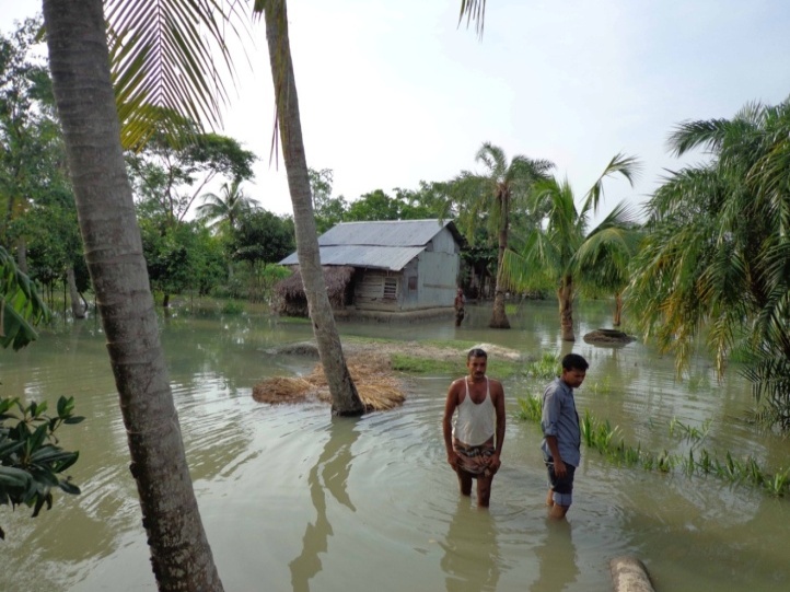
- The coast of Bangladesh consists of 19 districts, covers 32% of the country and accommodates more than 35 million people [3]. Increasing salinity is a crucial issue to the people of the coastal region of Bangladesh. Due to increasing salinity in the water and soil, the people of the region are suffering from scarcity of safe drinking water, irrigation, agriculture and other uses. Ecology of the coastal region especially in the southwest region is greatly concerned with salinity. A recent study indicates that the salinity affected area has increased from 8330 square km in 1973 to 10560 square km in 2009 (Soil Resource Development Institute, 2010) [1]. But it has been observed that all the coastal cultivable lands are not being utilized for crop production, mostly due to soil salinity. Increased soil salinity limits growth of standing crops and affects overall crop production, and also makes the soil unsuitable for many potential crops. Soil salinity has been considered a major constraint to food grain production in coastal areas of the country [4]. Increase the level of water salinity is impacting on the livelihood operation in several ways. First, it is making the whole coastal belt’s water availability unsecure and pushing poor people’s lives to a more vulnerable position than before (Fig. 1). Second, water salinity also causes an increase in soil salinity which further decreases the agricultural productivity and brings enormous pressure on food security [5]. In this situation management of salinity intrusion is the vital issue for Bangladesh. With the mission of saline water proofing by structural management, such as coastal embankment projects, dam, sluices etc. and coastal area zoning as non-structural management to change the land use and other activities can be the vision of sustainable livelihood and environment of Bangladesh. Hence diagnosis of the causes of saline intrusion is required.
 | Figure 1. Coastal zone of Bangladesh (Source: Islam, 2004) |
2. Materials and Methods
- This paper is based on available secondary sources on the cause of salinity intrusion on the coastal belt of Bangladesh. The study included the collection of information on various factors of salinity intrusion, particularly in the coastal region of Bangladesh. The resources are collected from online publication, books, government reports, international reports, scientific journals, and news articles, socioeconomic and statistical data used from the Bangladesh Bureau of Statistic (BBS).
3. Causes of Salinity Intrusion
- There are multiple reasons of salinity intrusion in the coastal area of Bangladesh. It includes natural, socioeconomic and political systems. All these systems are interlinked to each other. This section describes how these systems play a role in increasing salinity intrusion in the inland part of the country.
3.1. Natural Systems
- The natural systems include geographical location, sedimentation, sea level rise, cyclone, storm surge and tidal surge.
3.1.1. Critical Geographical Location of the Country
- Alluvial and deltaic sediments of the Ganga, Brahmaputra and Meghna rivers build the Bengal Basin, the eastern part, which is known as Bengal Flood Plain [6], the territory of Bangladesh. The country lies between the Himalayas in the north and the Bay of Bengal in the south. The basin of three river systems with an area of 1.6 million square kilometers passing through India, China, Nepal, Bhutan and Bangladesh, drains to Bay of Bengal through Meghna estuary. Water salinity in the coastal zone highly depends on the ice melting of the Himalayas and the discharge of these mighty rivers. The annual average discharge of these three rivers is 1.5 million cases which are generally characterized by seasonal variation. The peak flow occurs in the monsoon which is 80% and lean flow occurs in winter/dry season which is 20 % [7]. Hence the salinity also varies with the onset and recession of the monsoon. Decreasing in ice melting reduces river water discharge and consequently enhances the salinity in the coastal zone of the country.
3.1.2. Sedimentation
- The two Himalayan rivers, the Ganges and Brahmaputra, are among the most sediment-laden rivers in the world [8]. The GBM system carries 2.4 billion tons of sediment to the Bay of Bengal through the country. Part of the sediment goes to the Bay of Bengal and part of its deposits on the river beds and builds char lands. This fluvio-morphological activity reduces fresh water discharge to the estuary which leads to increased salinity in the tidal rivers and canals. Sedimentation in the tidal rivers of the southwestern area of Bangladesh is the main reason of the problem of water logging. These troublesome sediments have blocked the rivers, canals and caused upstream drainage congestion and flooding with saline water.
3.1.3. Sea Level Rise
- Due to various human activities, carbon dioxide and other greenhouse gases (GHG) are accumulating in the earth’s atmosphere, resulting in climate change. Rising temperature expand the ocean volume in two ways. Firstly, it melts mass volume of ice of the polar region and secondly, it causes thermal expansion of water of the ocean. Wigley and Raper (1987) commented that the relative contributions of thermal expansion and ice melting to this sea level rise are uncertain and estimates vary widely, from a small expansion effect through roughly equal roles for expansion and ice melting to a dominant expansion effect. These two factors increase volume of ocean water of the earth and rise in the sea level. And sea level rise is one of the major causes for salinity intrusion in the coastal belt of Bangladesh [9]. Bangladesh is highly vulnerable to saline water inundation due to sea level rise. World Bank (2000) showed 10 cm, 25cm and a 1.0 m rise in sea level by 2020, 2050 and 2100; affecting 2%, 4% and 17.5% of total land mass respectively [10]. Milliman et al. (1989; cited in Frihy, 2003) reported 1.0 cm per year sea level rise in Bangladesh [11]. UNEP (1989) showed 1.5 m sea level rise in Bangladesh coast by 2030, affecting 22,000 Sq. km (16% of total land mass) area with a population of 17 million (15% of total population) [12]. World Bank (2000) showed 10 cm, 25cm and 1 meter rise in sea level by 2020, 2050 and 2100 [13]. In a recent study, IWM (2006) predicted that flooding of coastal lands may increase by 21% by the year 2001 while it is 10.3% for the year 2050 with respect to the ordinary flooding condition when approximately 50% lands go under flood.
3.1.4. Cyclone and Storm Surge
- According to IPCC Third Assessment report, frequencies of tropical cyclone in Bangladesh will be intensified. The peak intensity and precipitation may increase to worsen the situation of the inland and riverine flooding. Moreover, the higher mean sea level will intensify the storm surges (Ali, 2010). Hence the highly growing population is becoming more vulnerable to tropical Cyclones [14]. Bangladesh experienced the deadliest cyclones in 1970, 1990, and 1992 and in 2007 [15]. The coastal zone of the country is still carrying salinity which intruded during Sidr and Aila Agriculture land and fresh water of ponds, canals and rivers are still saline contaminated and increase the sufferings of the coastal population.
3.1.5. Tidal Flooding
- Bangladesh faces semi diurnal tide i.e., two flood tide and two ebb tides in a day in a 6 hour consecutive time interval. Coincidence of heavy rainfall and flood tide occurred during monsoon urban area located in the coastal part of our country faces flooding due to water logging. During the monsoon period it make high tide and overflow saline water surrounding the coastal region (Fig. 2).
 | Figure 2. Tidal flood cause of salinity intrusion in coastal belt of Bangladesh |
3.1.6. Back Water Effect
- Backwater effect is a special type of saline water movement which takes place at the mouth of the river when fresh water is not sufficient enough for counterpart tide water moving towards river from sea. [16] identified different causes of backwater effect, among them i) South west monsoon wind ii) astronomical tides iii) storm surge are responsible for backwater effect in the mouth of the Meghna estuary. He further argued that sea level rise is the non-dynamic and long term cause of backwater effect. Back water effect (BWE is commonly pronounced in Bangladesh, particularly in the Meghna River estuary, through which about 90% of the river water in the country discharges into the Bay of Bengal. It is particularly important during flood seasons. As a consequence, floodwater inside the country continues to accumulate, bringing more areas under inundation and increasing the length and depth of inundation in areas already inundated, thus further aggravating the flood situation that already exists.
3.1.7. Changes in Ground Water Flow
- When groundwater levels in aquifers are depleted faster than they can recharge this is directly related to the position of the interface and determines the amount of saltwater that can intrude into the freshwater aquifer system. Since saltwater intrusion is directly related to the recharge rate of the groundwater, this allows for the other factor that may contribute to the encroachment of seawater into the freshwater aquifers.
3.2. Socioeconomic Systems
- Socioeconomic systems include anthropogenic activities such as shrimp farming, weak infrastructure and their poor maintenance, increased GHG emission, temperature rise and so on.
3.2.1. Continuous Shrimp Cultivation in Agricultural Land
- Shrimp aquaculture has raised serious concern about the impact of saltwater intrusion into the surrounding agricultural lands [17]. The spectacular rise of the demand of brackish water shrimp (Penaeus monodon) in the international market has stimulated the merest of its production. Presently its culture has taken a massive horizontal expansion and engulfed almost the entire coastal belt of the country [18]. Shrimp culture reduced the availability of cropping land by increasing soil salinity (Fig. 3). The practice of shrimp culture needs saline water as an input to the shrimp pond as a result salinity intrusion increase with expansion of shrimp culture. The extent of salinity in groundwater is also increasing because of continuous shrimp cultivation in the fresh agricultural land. Use of tube wells in coastal areas is not common, and most people use pond water or rainwater during the monsoon season. But in the dry season, it is difficult to procure potable water and they need to walk considerable distances to use water from a river or canal and expand saline water.
 | Figure 3. Saline water interns into Shrimp Gher and make salinity intrusion |
3.2.2. Weak Structure and Poor Maintenance
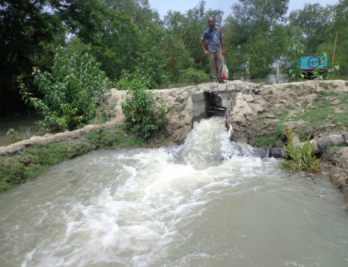
- Bangladesh government introduced polders to its coastal zones with the aid of the Netherlands in 1960s (Choudhury, n.d.). Bangladesh has 5,017 km embankment protecting the polders in coastal areas of the Bay of Bengal. The primary goal of launching polderization in Bangladesh was to protect the coastal inhabitant from regular natural disasters and to boost the agricultural production [19]. Bangladesh Water Development Board (BWDB) formerly known as Water and Power Development Authority (WAPDA) is in charge of maintaining and conducting the rehabilitation project of the polders [20]. But due to the poor maintenance, coastal polders in many places have started creating salinity intrusion to the agricultural fields. The BWDB has categorized 51 polders as "most vulnerable" and another 55 polders as "medium vulnerable". To cope with vulnerability, it is necessary to rehabilitate damaged infrastructure of the polders. Most of the sluice gates have been damaged through which saline water continuously inters into the inland. In addition, shrimp farmers cut the embankment to get saline water in their shrimp fields which also make the embankment weak. This weak embankment is easily damaged due to tidal pressure, particularly during full moon and the saline water enters in the polders (Fig. 4).
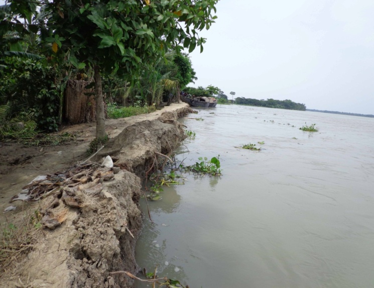 | Figure 4. Faulty management of embankment and river erosion is favorable to salinity intrusion |
3.2.3. Anthropogenic Climate Change Induced Factors
- Climate variables, such as precipitation, surface runoff, and temperature can play a big role in affecting saltwater intrusion. With lower precipitation amount and warmer temperature, the recharge rate will be much less due to lack of groundwater present and increase evaporation [21].
3.3. Political Systems
- And the political systems include weak water governance systems at local level, cross-boundary river policy, construction of barrages by the neighboring countries, etc.
3.3.1. Weak Water Governance Systems at Local Level
- Weak water governance systems at local level are another cause of salinity increase. Because salinity intrusion is not only natural phenomenon; it's also a human one. Numerous human activities—such as untimely water use, unplanned shrimp culture, insufficient or poorly maintained infrastructure, and inadequate management systems—can result in salinity intrusion.
3.3.2. Cross Boundary River Policy
- A total of 57 major rivers of Bangladesh have entered the country, of which 54 rivers are from India and 3 rivers are from Myanmar [22]. But among the 54 rivers coming from India more than twenty five rivers face one or more upstream diversion basically in dry months. For this reason, water scarcity during non-monsoon months cause of salinity increase in soil and water of coastal belt off Bangladesh. During the post-Farakka period, salinity in the south-west region of Bangladesh increased significantly. For example, at the Khulna station, the average monthly maximum salinity for April in the pre-Farakka period was 1626 μmho/cm. During 1976, when the Gorai discharge dropped to 0.5 m3/sec from its pre-Farakka average of 190m3/sec, maximum salinity in April increased to 13,000 μmho/cm. Recall that the Farakka Barrage was commissioned in April 1975. In recent years, extreme low flow in the Gorai River in the dry months has appeared to exacerbate the intrusion of saline water to the most inland parts of the southwest part of Bangladesh [23].
3.3.3. Lack of Capacity of Local Government
- Local government reforms in Bangladesh evolved very distinctly according to the needs of the ruling elites [24]. With the change of government, the policy of local government also kept changing. As a consequence, LGIs have not had any opportunity to act as effective tiers of governments with mandates and funds to carry out their roles and responsibilities. Independent reviews observed that Bangladesh has not been successful in establishing a decentralized system of governance and accountability. A World Bank review of the decentralization process in 19 countries ranks Bangladesh lowest in the decentralization scale [25]. Due to lack of capacity of LGIs, cannot take initiative to protect coastal polder, embankment, road and any kind of infrastructure as well as unplanned shrimp culture.
3.3.4. Structural Intervention in Upstream Neighboring Country
- The magnitude of salinity intrusion in coastal areas depends on a sensible balance between upstream freshwater flow and salt water from the sea. The water withdrawal system of human intervention in terms of the barrage and dam in the upstream neighboring country, have already affected upstream fresh water flow. The interface between freshwater and saline water is influenced by geology, hydrogeology, ground water heads and groundwater well pumping rates. But fresh water is important issue to counterbalance salinity intrusion at the upstream water intake. Due to geographical situation Bangladesh is most vulnerable to water withdrawal system by the upstream neighboring country. Farakka barrage is one of the worst factors for the decreasing water flow condition for internal river system of Bangladesh. Different types of anthropogenic interventions in the form of dam, barrage, and water diversion channel were undertaken in this river basin during the last century. This kind of intervention withdraws or diverts a substantial amount of river water from the upstream catchments of the GBM river basin and creates a low flow condition in the downstream rivers during the dry season. The water flow of the Ganges River in Bangladesh is largely influenced by the Farakka barrage. The water flow in the Ganges River in Bangladesh has been dropped a minimum 150m3/s at Hardinge bridge in 1995 from 2,0000 m3/s, which was the average minimum flow of the Ganges during post Farakka period [26]. It observed a notable change in the hydrology of the Ganges River at post Farakka period. He argued that the discharge during monsoon (July-October) increased during the dry season, (November-May) the discharge decreased significantly. Increased flow in the monsoon exacerbated the flooding condition and decreased flow aggravated salinity intrusion in the interior coast considerably [27].
4. Conclusions
- Salinity is one of the most severe environmental factors limiting the productivity of agricultural crops. Most crops are sensitive to salinity caused by high concentration of salts in the soil. As yield of crop production had been reduced due to salinity, the cost of production had gradually increased. In addition to this enormous financial cost of production, there are other serious impacts of salinity on infrastructure, water supplies, on soil structure and stability of communities. It is more disastrous for a low lying country like Bangladesh. But none can ignore the causes and effects of salinity which may occur in any country and any time. So it is high time to pay attention on it locally and globally to bring sustainability. In Bangladesh salinity intrusion is a time varying event and minimum during the monsoon (June-October) by push back of the rivers discharge at the salinity front in estuarine and floodplains. Maximum salinity levels occur during March-April. The increase of salinity intrusion and decrease of arability will be prevailing due to climate change effectively and reducing of flood plain. In this situation management of salinity intrusion is the vital issue for Bangladesh. With the mission of saline water proofing by structural management like coastal embankment projects, dam, sluices and coastal area zoning as non-structural management to change the land use and other activities can be the vision of sustainable livelihood and environment of Bangladesh. Further study to formulate the optimistic model for proper management by different option scenarios is essentially needed.
5. Recommendations
- Policy level:i) Develop Regional Policy and Strategy regarding Trans Boundary River. ii) Established Regional court for conflict Regulation and SAARC.iii) Develop strategic direction for Joint River Commission (JRC) to monitor River discharge.Practice level:i) Proper application of interventional Rules and acts of Trans boundary river.ii) Equipped JRC with necessary technology and manpower.iii) Built capacity of local government department and institutions on IWRM.iv) Advocacy with intergovernmental on structural interventions across Trans Boundary River.v) Massive awareness at the local level regarding water resource, its use and management.