American Journal of Geographic Information System

p-ISSN: 2163-1131    e-ISSN: 2163-114X

2017;  6(1A): 14-22

doi:10.5923/s.ajgis.201701.02


Producing a Landslide Susceptibility Map through the Use of Analytic Hierarchical Process in Finikas Watershed, North Peloponnese, Greece

Michalis Papadakis, Antonis Karimalis

Tunnel Construction Engineer, J&P AVAX S.A., Athens, Greece

Correspondence to: Michalis Papadakis, Tunnel Construction Engineer, J&P AVAX S.A., Athens, Greece.

Email:

Copyright © 2017 Scientific & Academic Publishing. All Rights Reserved.

This work is licensed under the Creative Commons Attribution International License (CC BY).
http://creativecommons.org/licenses/by/4.0/

Abstract

The main goal of the present study was to produce a landslide susceptibility map for the Finikas watershed that is located in the Achaia County, North Peloponnese, Greece, following the Analytic Hierarchical Process. Six parameters were analyzed, namely: lithological units, elevation, slope angle, slope aspect, distance from faults and distance from river network. Each parameter was classified into different classes and weighted according to their susceptibility to slide by implementing the Analytical Hierarchical Process. The landslide susceptibility map was reclassified into five classes of varying landslide susceptibility. The high and very high susceptibility class was estimated to cover the 8.18% and 19.55% of the research area, respectively. The relative landslide density for the high and very high landslide susceptibility class was estimated to be 69.45%. The developed model could be considered as a useful tool for the national and local authorities as it could assist in managing landslide related variables in a much easier and automated manner, maximizing the functionality of GIS environment and producing quite accurate landslide susceptibility maps.

Keywords: Landslide susceptibility mapping, Analytical hierarchical process, Finikas River, Greece

Cite this paper: Michalis Papadakis, Antonis Karimalis, Producing a Landslide Susceptibility Map through the Use of Analytic Hierarchical Process in Finikas Watershed, North Peloponnese, Greece, American Journal of Geographic Information System, Vol. 6 No. 1A, 2017, pp. 14-22. doi: 10.5923/s.ajgis.201701.02.

1. Introduction

Landslides are considered as geophysical and hydrological disasters that occur as unexpected and unpredictable movements, usually on unstable ground surface due to the force of gravity and the action of water [1]. They appear as one of the most frequent natural hazards with significant consequences to human life and the social - economic structure of a society [2].
As reviewed through the scientific literature, there is no agreement on the methods that one should use for landslide assessments [1-5]. However, according to [6], a landslide susceptibility analysis, an analysis that involves the determination of the spatial distribution of landslides, involves four processes: (a) the construction of a landslide inventory map, (b) the assessment of parameters that influence landslides, (c) the implementation of appropriate methods for determining the weights of each parameter and (d) the compilation of the landslide susceptibility map within a Geographic Information System (GIS) environment.
Several researchers have utilized multi criteria decision analysis (MCDA) techniques for landslide susceptibility and hazard assessments, since in most cases a mixture of qualitative and quantitative data are available [7]. In this context, data are processed using GIS and MCDA techniques to obtain information for making decisions. The most common approach involves obtaining expert opinion, through appropriate methods such as Analytical Hierarchical Process (AHP) to assigning weights to the landslide related parameters and then combining weights additively by weighted linear combination technique (WLC) to produce landslide susceptibility maps [8, 9].
Several studies have utilized AHP for landslide susceptibility mapping [10-12]. As referred by numerous researchers the main advantage of applying AHP as an expert based method in landslide susceptibility analysis are [9, 12]: all types of data concerning landslides can be included in the decision making process, expert’s judgment is formulated so that all information is taken into account, decision rules are based on expert’s knowledge and experiences, and finally inconsistencies in the decision process can be detected using consistency index values (Table 3). However, the main disadvantage of AHP is that subjective preference in the ranking of factors may differ from one expert to another [12].
The present study utilizes the Analytical Hierarchical Process (AHP) to produce a landslide susceptibility map, in Finikas watershed at North Peloponnesus, Greece.

2. Methodology

2.1. Analytic Hierarchical Process

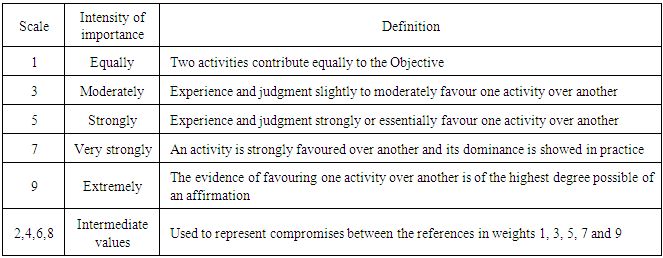
The AHP method was used in order to assign preferences among landslide related variables based on Saaty’s proposal [13, 14]. When applying AHP a reduction in the complexity of a decision problem can be achieved. In particular, a complicated problem can be simplified into a sequence of pair-wise comparisons. The AHP method involves the construction of decision criteria, that are compared following a two-part query that investigates which criterion is more important, and how much more important, using a numerical relational scale [14] (Table 1). By this the relative importance of each criterion can be calculated.
Table 1. Scale of importance between two parameters in AHP
     
By applying AHP, it is possible to evaluate pair-wise rating inconsistency. The calculated eigenvalues are a consistency measure that is an indicator of the inconsistencies or intransitivities in a set of pair-wise ratings. According to [14] the largest eigenvalue λmax is equal to the number of n comparisons. A measure of consistency, called consistency index CI, is defined as follows (Equation 1):
(1)
Saaty [14] randomly generated reciprocal matrixes using scales 1/9, 1/7, 1/5, 1/3, 1, 3, 5, 7, 9 to evaluate a so called random consistency index RI. Saaty [13] also introduced a consistency ratio CR, which is a comparison between the consistency index and the random consistency index. Since human judgments can violate the transitivity rule and thus cause an inconsistency, the consistency ratio (CR) is calculated to check the consistency of the performed comparisons (Equation 2).
(2)
If the value of the consistency ratio is smaller or equal to 10%, the inconsistency is acceptable, otherwise if the consistency ratio is greater than 10%, the subjective judgment needs to be revised [13].

2.2. Landslide Susceptibility Mapping

The next phase of the analysis was to combine all the weighted parameters by using the WLC method [15]. By applying the WLC method, the weighted values assigned for each parameter was numerically added resulting in the production of a landslide susceptibility map (Equation 3):
(3)
where Vwj the weight of the jth variable and cvj the standardized ratings of class kth of the jth variable.
To provide an easily to interpret map the produced landslide susceptibility map was classified into five categories of susceptibility, namely; very high susceptibility, high susceptibility, moderate susceptibility, low susceptibility and very low susceptibility [16]. ArcGIS 10.3 was used for compiling and analysing the data and also for producing the landslide susceptibility maps.

2.3. Validation

The final phase of the analysis is to validate the outcome of the AHP methodology. The approach followed in the present study was the one introduced by [17, 18]. The authors report that an ideal landslide susceptibility map must have an increasing landslide density ratio when moving from low susceptible classes to high susceptible classes and the high susceptibility class to cover small extent areas.

3. Study Area and Data

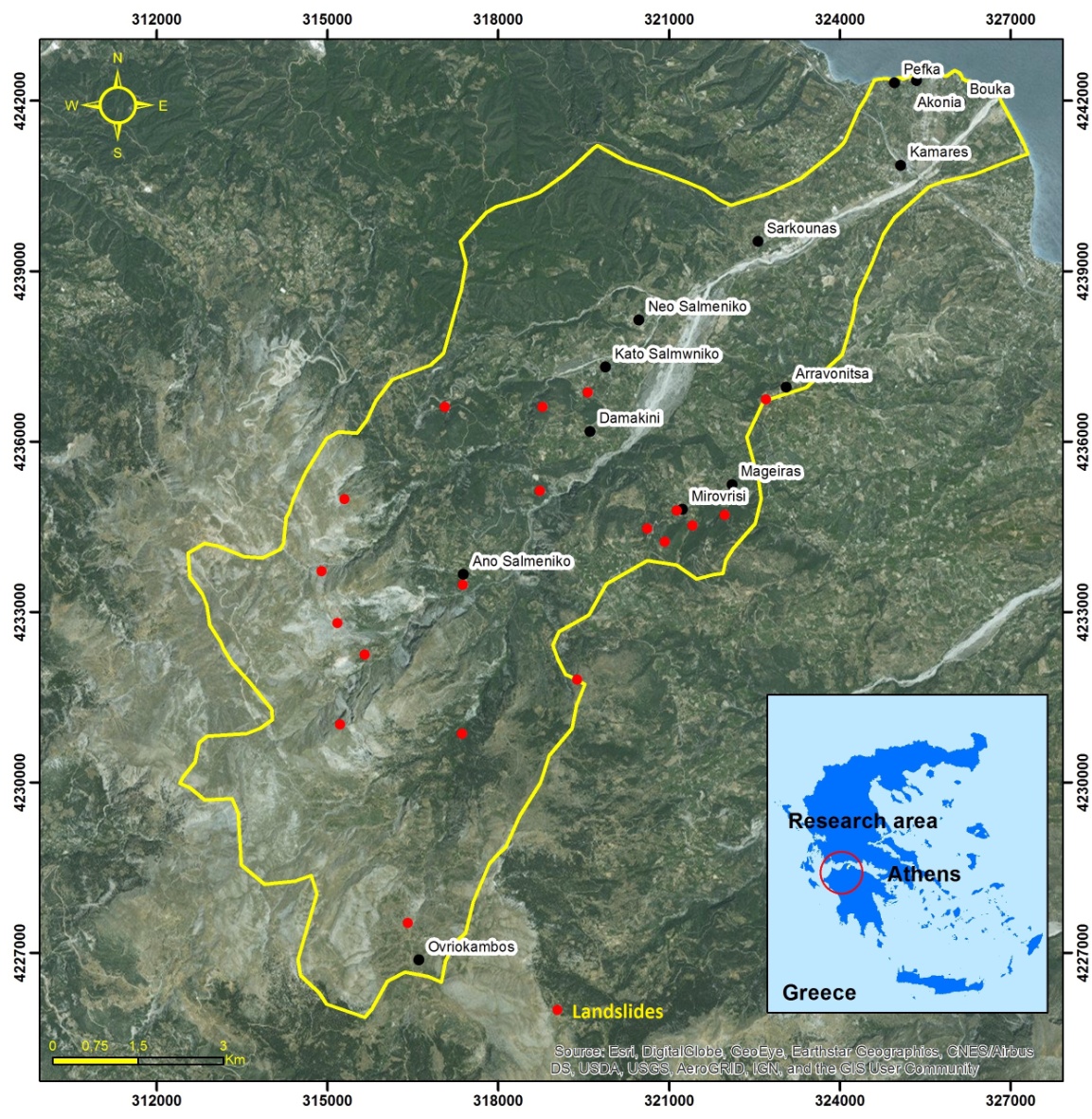
The study area is located at the northern part of Peloponnesus, Greece, covering an area of approximately 92 km2. The area lays between longitudes 312,000 and 327,000 and latitudes 4,224,000 and 4,242,000 (coordinates based on the Greek Coordinate system, EGSA’87). It involves the Finikas water sub-basin, with altitude ranging between 0 to 1900 m above sea level (Figure 1). A strong influence in shaping the terrain of the wider research area had the presence of Finikas River, the length of which reaches 22.5 km. The climate of the area is characterized as Mediterranean type (Csa) with mild winters and dry and hot summers. December appears to be the rainiest month, with mean precipitation reaching 128.9 mm followed by November (124.7 mm), while the driest month appears to be August (7.0 mm) followed by July (8.8 mm).
Figure 1. Study area
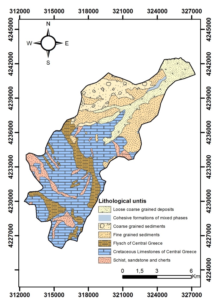
The geological formations that cover the wider area of research belong to the Olonos - Pindos tectonic zone, in which Upper Cretaceous – Eocene sedimentary sequences outcrop [19, 20]. According to the geological maps compiled by the Greek Institute of Geological and Mineral Exploration the geological formations that are present and cover the wider area are [21, 22]: Quaternary formations, Plio-Pleistocene deposits, flysch formations, limestones and dolomites and shale and cherts formations (Figure 2).
Figure 2. Lithological units
Landslide phenomena that have been recorded in the area are mainly caused due to the physical conditions and the general geotechnical behavior of the geological formation that cover the area. According to several researchers that have studied landslide phenomena in the wider area of research, in most cases, the main triggering variables were the combined action of intense rainfall events, seismic activity, while human activity played a much less important role [23-25]. Within the Finikas watershed most of the reported landslides were located along the road network and within the residential complexes, classified according to the Varnes Classification System [26], as rotational and translational slides, creep and also rockfalls (Figure 1).
Six landslide related variables were analyzed: lithological units, elevation, slope angle, slope aspect, distance from faults and distance from river network. In the following paragraphs a brief description, of the landslide related variables would be presented.
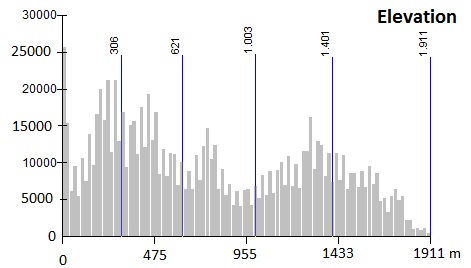
The elevation plays an important role in landslide susceptibility assessments [4, 27]. The mean elevation of the basin is 780 m, with the quarter of the study area (approximately 24%) showing elevation values less than 300 m (Figure 3).
Figure 3. Classification statistics of elevation
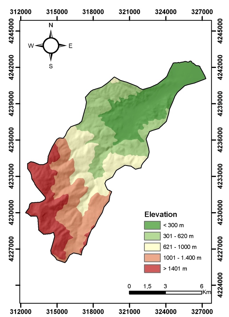
The elevation was classified into five classes (< 300 m, 301 – 620 m, 621 – 1000 m, 1001 – 1400 m, > 1401 m) (Figure 4).
Figure 4. Elevation
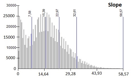
Slope is also considered as one of the most influencing factors to landslide occurrences [4]. In most cases, gentle slopes usually have a low frequency of landslide occurrences than steep slopes [4]. The mean slope within the basin is 16°. About 21% of the area has slope angle less than 7° and at least 6% slope angle higher than 33° (Figure 5).
Figure 5. Classification statistics of slope
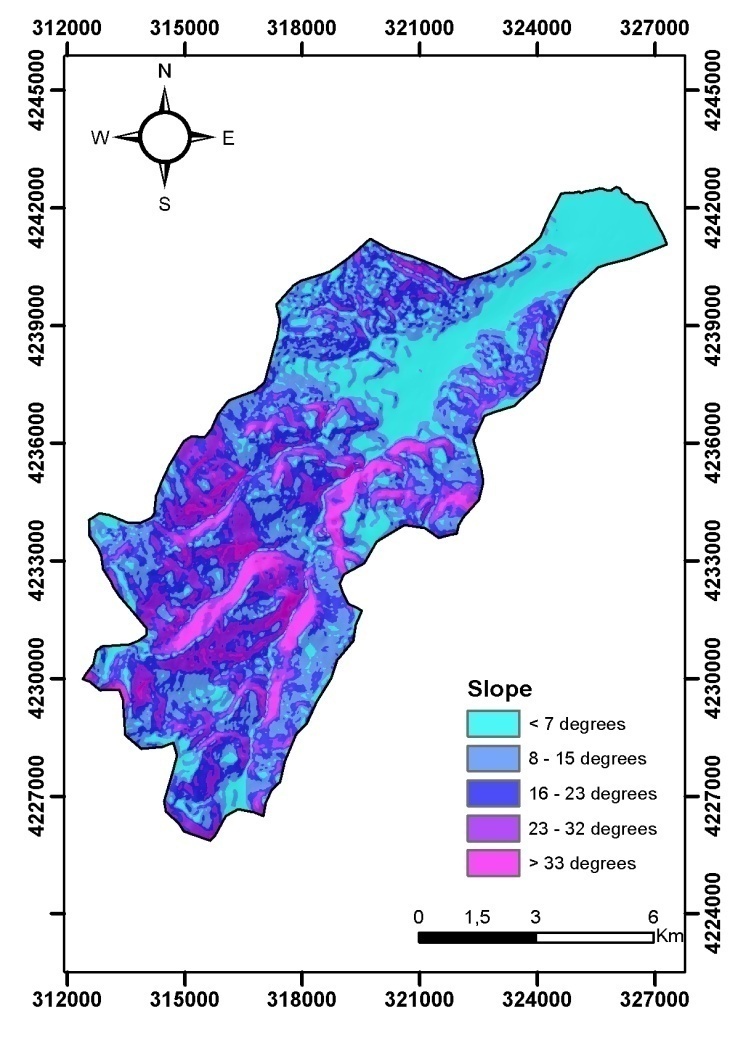
As for the slope layer it was classified into five classes according to the local geological and geotechnical conditions (<7°, 8°-15°, 16°-23°, 24°-32°, >33°) (Figure 6).
Figure 6. Slope
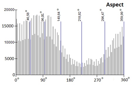
Concerning aspect the mean orientation of slope was estimate to be 147°, with approximately half of the study area showing orientation from NW to NE (Figure 7).
Figure 7. Classification statistics of aspect
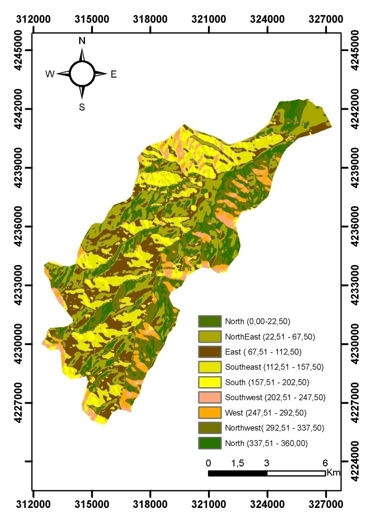
The aspect layer was classified into eight classes, namely: North (337.5-22.5), Northeast (22.5-67.5), East (67.5-112.5), Southeast (112.5-157.5), South (157.5-202.5), Southwest (202.5-247.5), West (247.5-292.5), Northwest (292.5-337.5) (Figure 8).
Figure 8. Aspect
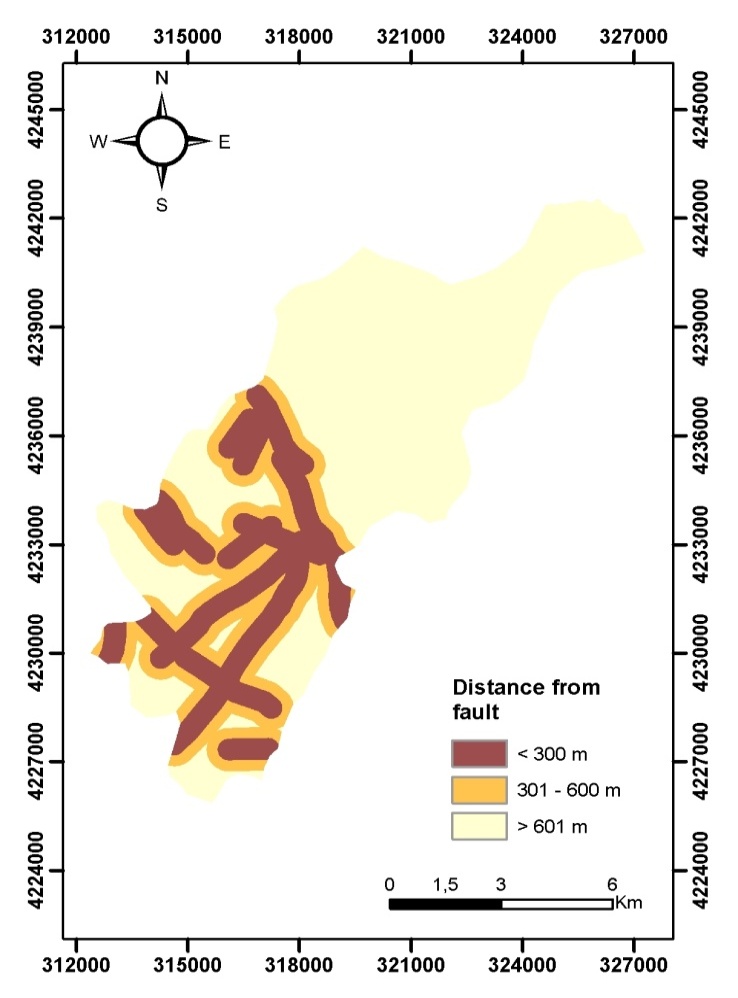
The tectonic characteristics, mainly faults were digitized from existing geological map, scale 1:50.000 [21, 22]. The research area was classified into a three class layer, areas that cover zones that have distance less than 300 m from faults, areas that cover zones that have distance between 301 and 600 m, and areas with distance greater than 601 m (Figure 9).
Figure 9. Distance from faults
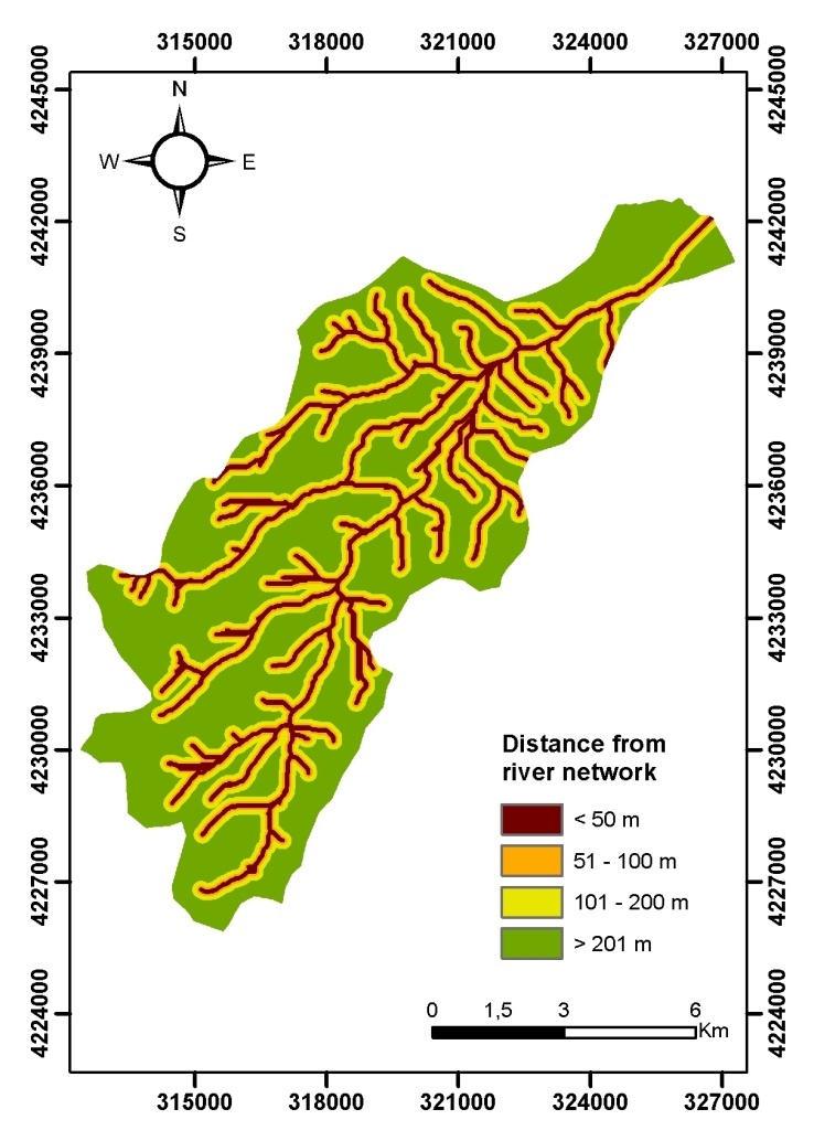
Finally, the distance to the river network was classified into a four class layer (< 50 m, 51 – 100 m, 101 - 200 m, > 201 m) (Figure 10).
Figure 10. Distance from river network

4. Results and Discussion

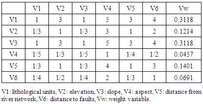
The outcomes of the implementation of AHP concerning the weighting of the landslide related variables and each variables class are presented in Tables 2, 3, 4, 5, 6, 7 and 8. As it can be seen the most important variables according to the performed weighing process are lithological units and slope, (both having values of 0.3118), followed by distance from river network (0.1401) and elevation (0.1214). The least important appears to be aspect (0.0457) followed by distance from faults (0.0691). The consistency index was estimated to be 0.021 a value that indicates that no inconsistency in the decision process has been detected.
Table 2. Weight coefficient of each landslide related variable
     
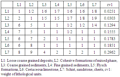
Table 3. Weight coefficient of lithological unit
     
The outcomes are persistent with related studies that impose the significance of lithology and slope in landslide susceptibility assessments [28, 29].
Table 3 illustrates the results of the implementation of AHP concerning the lithological unit variable. The 7th class, schist, sand and chert formations showed the highest coefficient (0.2962), followed by limestone (0.1851), flysch formations (0.1783) and fine grained sediments (0.1555). The consistency index for the lithological unit variable was estimated 0.028 indicating none inconsistency.
High percentage of landslide occurrence has been observed in Plio-Pleistocene sediments, flysch formations, and Cretaceous limestone, findings that are in agreement with previous studies [23, 23]. According to [24] the Plio-Pleistocene sediments are more susceptible in rotational slides, movements that are influenced by the heterogeneous structure and the degree of looseness. In areas covered by flysch formations, rotational and translational slides, is attributed to the anisotropic geotechnical behavior of the formation. Finally, the Cretaceous limestone, appear susceptible to rockfalls, that are influenced by the degree of weathering and fragmentation, the orientation of the discontinuities surfaces and the intense morphological relief.
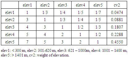
Table 4 illustrates the results of the implementation of AHP concerning the elevation variable. The 5th class (>1401 m) showed the highest coefficient (0.4550). The consistency index for the variable was estimated 0.046 indicating none inconsistency.
The elevation could be considered as a variable that indirectly contributes to the slope failure. The descriptive analysis performed in the study showed that, areas with elevations higher than 600 m, experience considerable higher chance of landslide occurrence.
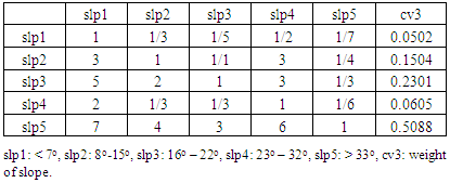
Table 5 illustrates the results of the implementation of AHP concerning the slope variable. The 5th class (> 33°) showed the highest coefficient (0.5088), followed by the 3rd class (0.2301). The consistency index for the slope variable was estimated 0.008 indicating none inconsistency.
Table 4. Weight coefficient of elevation
     
Table 5. Weight coefficient of slope
     
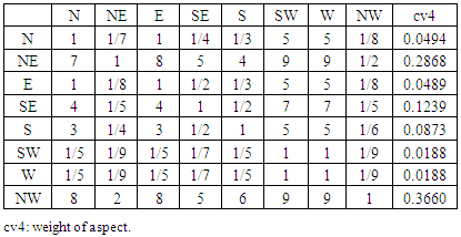
Table 6 illustrates the results of the implementation of AHP concerning the aspect variable. The 8th class (Northwest) showed the highest coefficient (0.3660), followed by the 2nd class (Northeast), with coefficient value 0.2868. The consistency index for the variable was estimated 0.077 indicating none inconsistency.
Table 6. Weight coefficient of aspect
     
In Greece certain slope orientations are associated with increased snow concentrations and consequently longer periods of freeze and thaw action processes. These slopes can favor higher erosion and weathering processes as the climatic conditions facilitate the cyclic alternation of dry and wet periods. The SE–SW (135°– 225°) oriented slopes are mostly affected by rainfalls and the NW–NE (315° – 45°) oriented slopes are mostly sunless, affected by the increased snow concentrations [28-30].
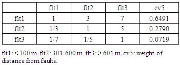
Table 7 illustrates the results of the implementation of AHP concerning the distance from faults variable. The 1st class (< 300 m) illustrated the highest coefficient (0.6491), whereas the consistency index for the variable was estimated 0.077, indicating none inconsistency.
Table 7. Weight coefficient of distance from faults
     
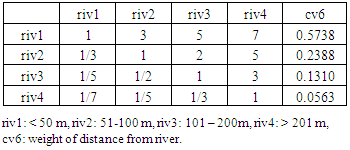
Finally, table 8 illustrates the results of the implementation of AHP concerning the distance from river variable. The 1st class (> 50 m) has been assigned with the highest coefficient (0.5783), with the calculated consistency index equal to 0.028, indicating also none inconsistency.
Table 8. Weight coefficient of distance from river
     
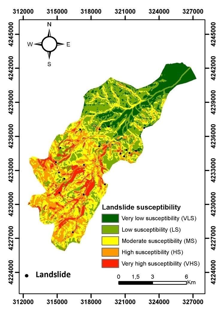
Based on the weighting coefficients estimated by the AHP the landslide susceptibility values were obtained and produced the landslide susceptibility map (Figure 11). The high and very high susceptible zones are located at the southern region of the research area, in areas with altitude higher than 600 m, following the spatial distribution of the river network.
Figure 11. Landslide susceptibility map
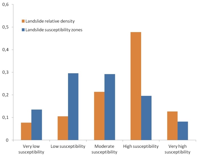
Concerning the produced landslide susceptibility map, the very high and high susceptibility class was estimated to cover 8.18% and 19.55% respectively. The relative landslide density for the high and very high landslide susceptibility class was estimated to be 69.45% (Figure 12). The findings of the analysis were partly persistent with the notion that an ideal landslide susceptibility map should have an increasing landslide density ratio when moving from low susceptible classes to high susceptible classes and that the higher susceptibility class cover small extent areas. Although the very high susceptibility area covers small extent, it also exhibits relative low landslide density. This may be justified by the fact that the very high susceptibility area covers mainly areas that are remote and difficult to reach and thus several landslide incidences that may have occurred have not been documented.
Figure 12. Validation

5. Conclusions

The presented study applied Analytical Hierarchical Process in order to produce a landslide susceptibility map in Finikas watershed basin, North Peloponnesus, Greece. Six landslide variables were analysed and included in the study, namely lithological units, elevation, slope, aspect, distance from faults and distance from river network.
According to the findings of the AHP implementation, lithological unit and slope were among the most significant variables that contribute to landslide susceptibility. The predictive power of the AHP model was estimated to be relative good since 69.45% of the recorded landslides fall in the high and very high landslide susceptibility zone.
Because of its simplicity and robustness in obtaining weights and integrating heterogeneous data, the AHP can be considered as an ideal tool for assisting in managing landslide related variables in a much easier and automated manner, maximizing the functionality of GIS environment and producing quite accurate landslide susceptibility maps.

References

[1]  Carrara, A., Guzzetti, F., Cardinali, M., Reichenbach, P., 1999. Use of GIS Technology in the Prediction and Monitoring of Landslide Hazard. Natural Hazards, vol. 20 (2-3), pp. 117-135.
[2]  Aleotti. P., Chowdhury, R., 1999. Landslide hazard assessment: Summary review and new perspectives. Bulletin of Engineering Geology and the Environment, 58(1), 21-44.
[3]  Guzzetti, F., Carrara, A., Cardinali, M., Reichenbach, P., 1999. Landslide hazard evaluation: a review of current techniques and their application in a multi-scale study, Central Italy. Geomorphology, 31, 181–216.
[4]  Dai, FC., Lee, CF., Ngai, YY., 2002. Landslide risk assessment and management: an overview. Engineering Geology, 64(1): 65–87.
[5]  Glade, T., Anderson, M., and Crozier, M.J., 2005. Landslide Hazard and Risk. John Wiley & Sons, Ltd., Chichester, England, 802pp.
[6]  van Westen, C., 1997. Statistical landslide hazard analysis. ILWIS 2.1 for windows application guide. Enshede, The Netherlands, ITC Publication N. 15: 73-84.
[7]  Ayalew, L., Yamagishi, H., 2005. The application of GIS-based logistic regression for landslide susceptibility mapping in the Kakuda-Yahiko Mountains, Central Japan. Geomorphology, 65: 15–31.
[8]  Park, N.W., Chi, K.H., and Kwon, B.D., 2004. Application of fuzzy set theory for spatial prediction of landslide hazard. In Proceedings of the Symposium on Geoscience and Remote Sensing, vol. 5, pp. 2988–2990.
[9]  Komac, M., 2006. A landslide susceptibility model using the analytical hierarchy process method and multivariate statistics in penialpine Slovenia. Geomorphology, 74(1–4), 17–28.
[10]  Castellanos Abella, E.A., 2008. Multi-scale Landslide Risk Assessment in Cuba. ITC dissertation 154 Thesis, Utrecht University, Utrecht, 273 pp.
[11]  Akgun, A., Dag, S., Bulut, F., 2008. Landslide susceptibility mapping for a landslide-prone area (Findikli, NE of Turkey) by likelihood frequency ratio and weighted linear combination models. Environ Geol 54(6):1127–1143
[12]  Thanh, LN., De Smedt, F., 2012. Application of an analytical hierarchical process approach for landslide susceptibility mapping in A Luoi district, Thua Thien Hue Province, Vietnam. Environmental Earth Sciences. v66 i7. 1739-1752.
[13]  Saaty T.L., 1977. A scaling method for priorities in hierarchical structures. J Math Psychol, 15, 234–281.
[14]  Saaty, T.L., 2000. Fundamentals of Decision Making and Priority Theory with the Analytic Hierarchy Process. 2nd Edn., RWS Publications, Pittsburgh, USA
[15]  Malczewski, J., 1999. GIS and Multicriteria Decision Analysis. (John Wiley and Sons, New York, 1999).
[16]  Feizizadeh, B., Blaschke, T., 2013. GIS-multicriteria decision analysis for landslide susceptibility mapping: comparing three methods for the Urmia lake basin, Iran. Natural Hazards, 65(3): 2105-2128.
[17]  Can, T., Nefeslioglu, HA., Gokceoglu, C., Sonmez, H., Duman, TY., 2005. Susceptibility assessments of shallow earthflows triggered by heavy rainfall at three catchments by logistic regression analysis. Geomorphology, 72(1–4), 250–271.
[18]  Pradhan, B., Lee, S., 2010. Delineation of landslide hazard areas on Penang Island, Malaysia, by using frequency ratio, logistic regression, and artificial neural network models. Environmental Earth Sciences, 60, 1037–1054.
[19]  Brunn, JH., 1956. Contribution à l'étude géologique du Pinde septentrional et d'une partie de la Macédoine occidentale. Annales géol. pays hellén.,1re série, t. 7, 358 p., 20 pl.
[20]  Aubouin, J., 1959. Contribution a l’ etude geologique de la Grece septentrionale: les confins de l’ Epire et de la Thessalie. Ann. Geol. Pays Hellen. Vol. 10, p. 1-483.
[21]  IGME, 1971. Geological map of Greece, at a scale of 1:50,000, Nafpaktos sheet, Athens.
[22]  IGME, 1984. Geological map of Greece, at a scale of 1:50,000, Chalandritsa sheet, Athens.
[23]  Koukis, G., Rozos, D., 1982. Geotechnical conditions and landslide phenomena in Greek territory, in relation with geological structure and geotectonic evolution. Mineral Wealth 16:53–69, (in Greek, with summary in English).
[24]  Rozos, D., 1989. Engineering-geological conditions in the Achaia County. Geomechanical characteristics of the Plio-pleistocene sediments. PhD thesis, University of Patras, Patras, pp 453 (in Greek, with extensive summary in English).
[25]  Koukouvelas IK, Doutsos, T., 1997. The effects of active faults on the generation of landslides in NW Peloponnese, Greece.In: Proc of international symposium of IAEG in engineering geology and the environment, Balkema, Rotterdam, vol 1, pp 799–804.
[26]  Varnes, DJ., 1984. International association of engineering geology commission on landslides and other mass movements on slopes: landslide hazard zonation: a review of principles and practice. UNESCO, Paris 63 pp.
[27]  Pachauri, A.k., Pant, M., 1992. Landslide hazard mapping based on geological attributes. Engineering Geology, 32, 81–100.
[28]  Koukis, G., Ziourkas, C., 1991. Slope instability phenomena in Greece: a statistical analysis. Bulletin of the International Association of Engineering Geology 43(1): 47–60.
[29]  Koukis, G., Sabatakakis, N., Nikolaou, N., Loupasakis, C., 2005. Landslides hazard zonation in Greece. Proc of open symp. on landslides risk analysis and sustainable disaster management by International Consortium on Landslides, Washington USA, Chapter 37, pp 291-296.
[30]  Rozos, D., Pyrgiotis, L., Skias, S., Tsangaratos, P., 2008. An implementation of rock engineering system for ranking the instability potential of natural slopes in Greek territory: an application in Karditsa County. Landslides, 5(3), 261–270.