-
Paper Information
- Paper Submission
-
Journal Information
- About This Journal
- Editorial Board
- Current Issue
- Archive
- Author Guidelines
- Contact Us
Science and Technology
p-ISSN: 2163-2669 e-ISSN: 2163-2677
2021; 11(1): 30-39
doi:10.5923/j.scit.20211101.03
Received: Nov. 21, 2021; Accepted: Dec. 10, 2021; Published: Dec. 24, 2021

Flood Mitigation of Goro Catchment in Dire Dawa, Ethiopia
 Abstract
 Reference
 Full-Text PDF
 Full-text HTML
Wahaj Ahmad Khan, Mikiya Demissie
Department of Civil Engineering, School of Civil Engineering & Architecture, Dire Dawa University, Institute of Technology, Dire-Dawa, Ethiopia
Correspondence to: Wahaj Ahmad Khan, Department of Civil Engineering, School of Civil Engineering & Architecture, Dire Dawa University, Institute of Technology, Dire-Dawa, Ethiopia.
| Email: |  |
Copyright © 2021 The Author(s). Published by Scientific & Academic Publishing.
This work is licensed under the Creative Commons Attribution International License (CC BY).
http://creativecommons.org/licenses/by/4.0/

Flood hazard has long history in Dire Dawa which is surrounded by the catchment of highland as well as low land. The city has been repeatedly devastated by flood disasters in the past. The main objective of the project is to estimate the peak Runoff and to assess flood mitigation measure. To achieve this objective, different prevention methods are used by using structural and non-structural approaches. Arc GIS 9.2 software is used to get soil type and land use, SCS curve number to get maximum run off, sieve analyses to know the grading characteristics of soil. It is concluded that the majority of soil particle are well graded, however there is also an indication of poorly graded soil. There is an effect of erosion and scouring. The monthly rainfall data analysis shows that, during the last 66 years from 1952 to 2017, the maximum values of monthly rainfall is calculated as 271.9 mm and the mean average value as 92.1mm. An increase in rainfall intensity, in association with other factors such as land-use change, increased population settlement along the river bank in the downstream area have contributed to raise the risk level of flash floods. The peak flood runoff as well average runoff has been estimated using soil conservation curve number method. The average value and peak value of runoff are 9.94 mm and 33.9 mm respectively. In addition to this, the maximum runoff is found in Cambisol soil. The mitigation has done by selecting appropriate structural and nonstructural approaches. The design and analysis of Groyne and retaining wall is done and selected for controlling and regulating the river bed configuration for effective and safe movement of floods and river sediments.
Keywords: Soil Conservation Service, Curve Number, Antecedent Moisture Condition, Coefficient of curvature
Cite this paper: Wahaj Ahmad Khan, Mikiya Demissie, Flood Mitigation of Goro Catchment in Dire Dawa, Ethiopia, Science and Technology, Vol. 11 No. 1, 2021, pp. 30-39. doi: 10.5923/j.scit.20211101.03.
Article Outline
1. Introduction
- Nowadays, extraordinary floods are common to many parts of Ethiopia every year causing a lot of losses to human lives as well as damage to property. Dire Dawa is one of the towns facing such problem. The flood at Dire Dawa is as a result of flash flood from rainfall on the southern highlands.Historical documents suggest that Dire Dawa has been facing flood problems since 1953; Goro River is one of the major areas that experience a flash flood, this flood arises from the highlands of Oromiya region (mainly Dengego and Kersa). There are different factors that trigger flooding in this area. Many people have been associating floods and flash flood Dire Dawa with torrential rainfall occurring in the main rainy season (mid-March to April). Due to degradation, the forests of the highlands had been cleared. As a result, the soil has been washed out and deposited in the river banks, in which the water holding capacity of the river is decreasing. Dire Dawa, one of the major cities of Ethiopia, was repeatedly hit by catastrophic floods. The city has worst history of flood disasters. Major severe flooding submerged the city in 1981, 1990, 2000 and 2005. The Dachatu, Goro and Butteji rivers flood seasonally as rain falls from the highlands of eastern Hararghe (OCHA, 2006).
2. Literature Review
- The nature is beyond the control of human being. Heavy rainfall, tornado, cyclone etc cannot be controlled and natural calamities keep occurring. The problem of flood damage is universal. Every country faces the calamity due to flood. The causes of flood should be ascertained by different investigations and precautionary measures should be taken to reduce the destructive effect of the flood even though it is beyond the control of human being. Flood risks can only be mitigated but not removed. Floods usually result from a combination of meteorological and hydrological extremes, such as extreme precipitation and flows. However they can also occur as a result of human activities: flooding of property and land can be a result of unplanned growth and development in floodplains, or from the breach of a dam or the overtopping of an embankment that fails to protect planned developments.Descriptions and categorizations of floods vary and are based on a combination of sources, causes and impacts. Based on such combinations, floods can be generally characterized into river (or fluvial) floods, pluvial (or overland) floods, coastal floods, groundwater floods or the failure of artificial water systems. Based on the speed of onset of flooding, floods are often described as flash floods, urban floods, semi-permanent floods, and slow rise floods.A representative number of floods in different parts of the world are highlighted below (Donald W. Knight, et.el. (2006))1. Bangladesh May 1997Tropical cyclone with winds up to 200 km/hr occurred. The storm surge hit at low tide, which reduced the damage. Many lives saved by use of cyclone shelters. Estimated damage of 95 killed, 2 million affected and 500,000 houses ruined.2. Mozambique, January–February 1997Heavy rain from mid-January caused severe floods in central and North-Western Mozambique, causing deaths and affecting 400,000 people. Appeal for food, medicine, seeds and funds for transport of emergency items and rehabilitation of roads and bridges.3. USA, Mississippi, 1993Once in 500 year flood event. Floods inundated 75 towns, causing 47 deaths, $11 billion worth of damage, 20 million acres of agricultural land damaged, 45,000 homes damaged or destroyed and 74,000 people evacuated. Whole towns are now being relocated – but not major cities like St Louis.4. Dire Dawa, Ethiopia, August 5/6 2006 (Tesema Habte, April2009).On the night of 5/6 August 2006, the most severe and recent flood to date swept through Dire Dawa, resulting in over 256 fatalities, rendering nearly 10,000 homeless and significant damage to the flood defenses, public infrastructure, housing and livelihoods. The high death toll was largely due to the fact that the flood peak occurred at night when people were asleep.Various studies have been conducted in Dire Dawa regarding flooding by Tsegaye (2006); Dechasa (2006); Daniel etal. (2006); Bezuayehu (2006); Yalemtsega (2006). All of these studies discusses on the causes of flooding in Dire Dawa. Tsegaye focused on hydro metrological characteristics; Dechasa on improving the existing farming system in the upper catchment; Daniel et al. focused on the rapid growing of population pressure aggravated flood disaster in Dire Dawa; Yalemtsega concerned on how absence of storm water management exposes flood hazards. Still there are no studies have done on Goro River especially on mitigation.In the town of Dire Dawa, until recently due attention has not been given to mitigate the challenges of flooding and the disaster it causes. This is mainly due to lack of sufficient studies that provide adequate information of the impacts of flood disasters on the economic, social and infrastructural aspects of the town, insufficient documents on the causes of the problem and mitigating strategies in the future, and/or less attention paid by policy makers.
3. Methodology
- This study was conducted in Dire Dawa city, Ethiopia which is located in the eastern part of Ethiopia. It is located between 9°28.1` to 9°49.1` North Latitude and 41°38.1` to 42°19.1` Longitudinal lines. Dire Dawa City is located in the Ethiopian rift valley with an altitude of 1000–1200 m above sea level and surrounded by mountainous districts of Oromia Regional States. The city is dissected by five large and small rivers Dechatu, Goro, Melka Jabdu, Laga Hare and Butuji rivers.The Goro watershed is an elongated shaped with relatively wider areal coverage in the headwater region, but narrows downstream after the confluence, from which the main trunk of the stream starts. The river is sinuous and narrower in its middle reach. Soil Conservation Service (SCS) has been applied in the present study for the estimation of flood discharge. This method involves various types of information related to land-use, soil type, initial abstraction and Hydrologic Soil Group. Arc GIS 9.2 (Arc CN tool) software is used in the study.In the present study Goro watershed is taken as case study for estimation of runoff by Soil conservation Service Curve Number (SCS CN) method. The SCS-CN method is used to estimate surface runoff depth, when adequate hydrological information is not available for un-gauged catchment.
4. Data Analysis
4.1. Rainfall Analysis
- The monthly rainfall data analysis shows that, during the last 66 years from 1952 to 2017, the maximum values of monthly rainfall is 271.9 mm and the mean average 92.1mm. An increase in rainfall intensity, in association with other factors such as land-use change, increased population settlement along the river bank in the downstream area have contributed to raise the risk level of flash floods in the town of Dire Dawa to the point that floods caused severe socio-economic impacts in the town and rural kebeles of DireDawa. This result is considered as one main factor responsible for the increase in the frequency of high flash floods in the town of Dire Dawa. The study of flood is carried out with the help of ARC–GIS and SCS-CN (Soil conservation service curve number. The Soil Conservation Service Curve Number (SCS-CN) approach is widely used for predicting direct runoff volume for a given rainfall event. The behavior of the soil is studied to recognize the behavior of the soil in order to differentiate poorly graded oil and well graded soil.
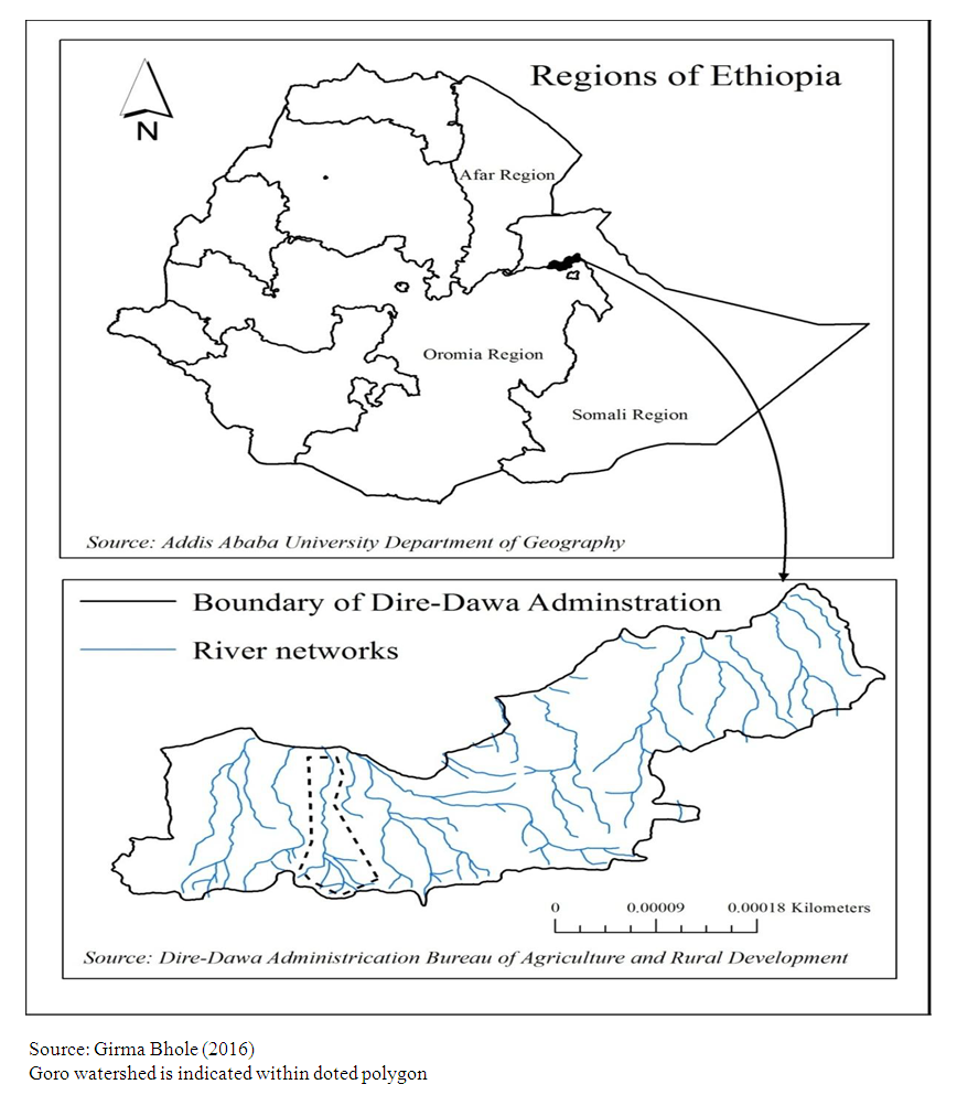 | Figure 1. Location of Study Area |
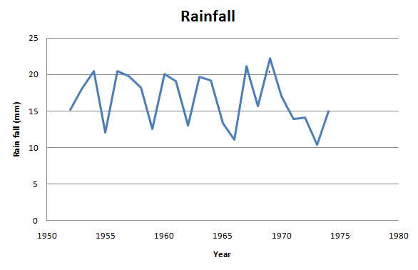 | Figure 2. Yearly average rainfall from 1952-1974 |
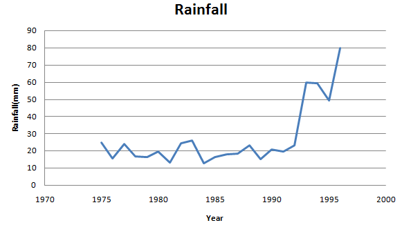 | Figure 3. Yearly average rainfall from 1975-2017 |
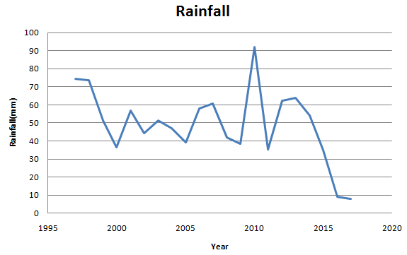 | Figure 4. Yearly average rainfall from 1996-2017 |
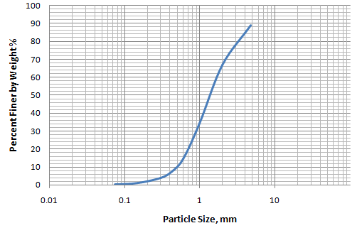 | Figure 5. Particle size Distribution curve |
4.2. Grain Size Analysis
- A number of samples were collected from various locations and Sieve Analysis was carried out in the laboratory. Based upon the coefficient of uniformity and coefficient of curvature result, it is found that the soil has uniformly graded soil which shows moderate erosion.
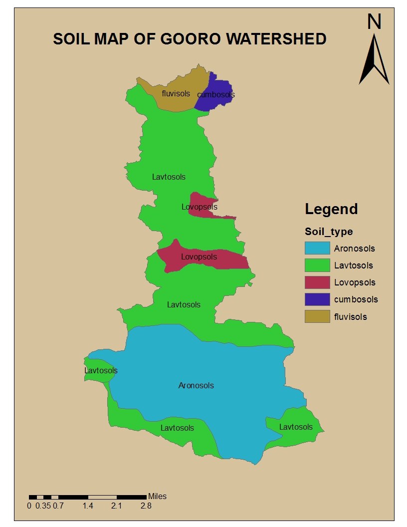
4.3. Land Use/Cover Map of Goro Catchment
- According to Moussa et al., (2003) the main hydrological processes are affected by the spatial variability of soils, topography, land use/cover, climate, and human-induced changes and management. Land use/cover change is one of the most prominent component in the hydrological processes of a given area, it is important to evaluate the changes that undergone in a given catchment so as to understand the hydrological behavior of the catchment. Accordingly, the major land use/cover changes that observed in Goro catchment was studied based on the thematic land use/cover map.In this study land use/cover map was developed using Arch-GIS and depicted in figures 6 and 7.
|
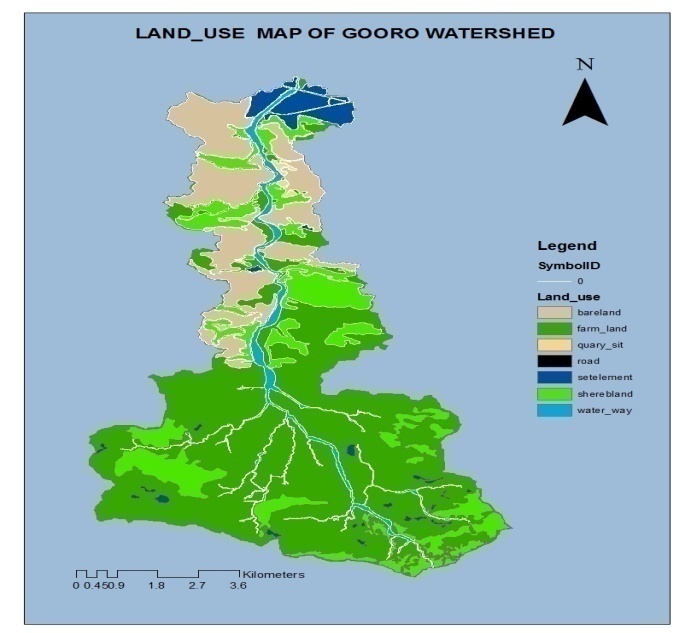 | Figure 6. Land use/cover map Goro catchment |
 | Figure 7. Soil Data in the Required Range |
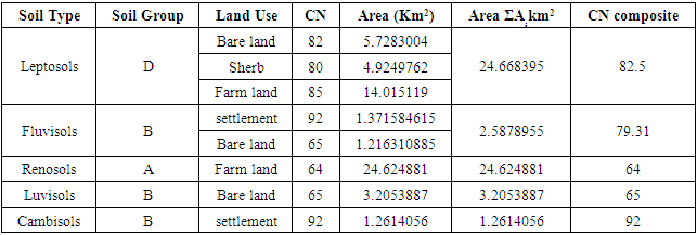
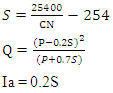 Monthly Average rainfall data, collected for a period of 1952 to 2017 was used as input. Weighted CN for each sub area in the study area is worked out using the following equation.
 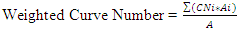 The average value and peak value of runoff are 9.94 mm and 33.9 mm respectively.
4.4. Structural Approach
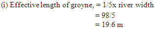
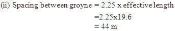
4.4.1. Design of Groyne
- In the Goro River, no Groynes were constructed. This type of structures is very necessary especially near to the bridge because it minimizes the velocity as well it controls the degradation and scouring effect near to the bridge. Many bridges are failed due to the scouring effect.
 (iii) Top width provided = 4.5m (iv) Free board provided = 1.5m (v) Side slope provided = 2:1(vi) Size of stone for pitching:-Weight of stone,
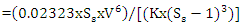 Where
Where 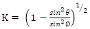 Angle of repose of material of protection
  Angle of sloping bank,
 (vii) V= 0.065d 0.5Where V is the mean velocity of flow (m/s) and d is the maximum diameter of boulder in mm.
 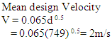 (vii) Weight of Stone/Boulder in Kg (W)
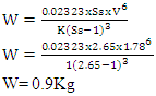 (viii) Thickness of pitching,
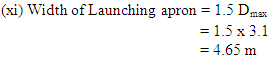
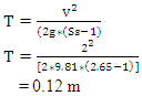 (ix) Launching apron V = 4.893 S0.5S = (2/4.893)2S = 0.17 m(x) Scour depth D= 0.473 (Q/f) (1/3)Silt factor (f) =
  where d= mean diameter of river bed material in mm.
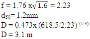
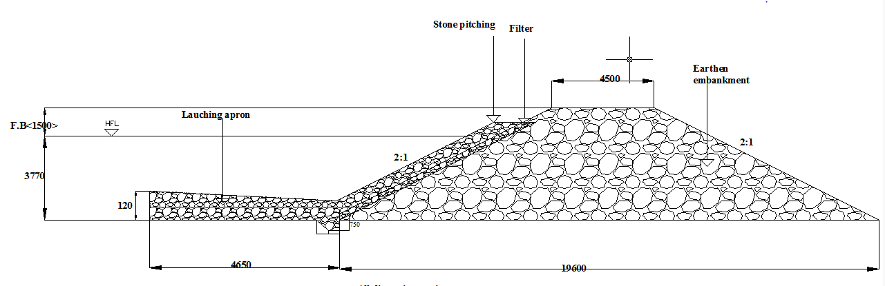 | Figure 8. Groyne |
4.4.2. Design of Cantilever Retaining Wall
- The previous constructed retaining wall was failed due to improper fixation as well as the insufficient depth of footing, so it is an urgent need to redesign these structures so that there should not be any kind of failures and the people living near the surrounding should be safe against the flooding. The proposed gravity retaining wall height is 8m.According to EBCS-7 the gravity retaining wall height should be less than or equal to 6m. So, there is a need to change gravity retaining wall to cantilever wall.As per the soil data report, the unit weight of the soil is very low. Due this result the bearing capacity still is not adequate to bear the load. So it requires proper stabilization of the soil beneath the retaining wall.At the face of the retaining wall there is scouring effect, so it is necessary to increase the depth of footing.Provide reinforcement bar for retaining wall pad parallel to the width of retaining wall.
 c/c 350 mm is used for parallel to length of retaining wall.Provide Reinforcement Bar for retaining wall pad Perpendicular to the width of retaining wall
 c/c 350 mm is used, for parallel to width of retaining wall. Reinforcement bar is provided to the face of retaining wall to resist water pressure.
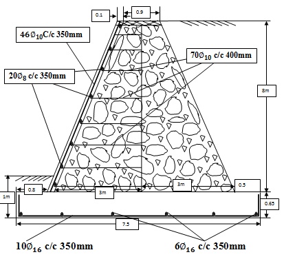 | Figure 9. Cantilever Retaining wall |
4.4.3. Non- Structural Approaches
- There are many soil conservation measures but the most outstanding of these is the use of vegetative soil and moisture conservation measures that are cheap, replicable, sustainable and fully effective in stopping erosive degradation.Vegetation cover:• prevents splash erosion by intercepting the direct impact of rain drops• reduces sheet erosion• slows runoff• anchors and reinforces the soil• improves soil quality by organic material • improves infiltration capacity • enhances the soil fauna Plantation of Vetiver grass Researchers all over the world have found that Vetiver as a hedge is the ideal plant to conserve soil and rehabilitate eroded land. This grass has been used for soil and water conservation in agricultural lands for many years but its related impact on land stabilization, soil erosion and sediment control only started in the late 1980s following its promotion by the World Bank. Vetiver grass has unbelievable adaptations. It is known to grow in areas with average annual rainfall between 200 and 6000 millimeters and with temperatures ranging from 1 to 45 degrees Centigrade. It will grow in all types of soil regardless of fertility, pH or salinity and over an extremely wide range of soils and climate. It is a perennial grass and can with stand drought, flood and long period of water logging. It is highly tolerant to toxic levels of Aluminum, Manganese, Arsenic, Cadmium, Chromium, Nickel, Copper, Mercury, Lead, Selenium and Zinc. It is highly resistant to pests, diseases, fire and other adversity.The Vetiver Grass Technology is simply the establishment of a narrow (less than 1 meter wide) live stiff grass barrier, in the form of a hedge, across the slope of the land. Vetiver grows quickly and forms a dense, permanent hedge which will slow down rainfall runoff, diverts and spreads it evenly, forming a very effective filter. It will trap runoff sediments to create natural terraces. Vetiver is considered as a very deep-rooted penetrating grass variety which develops a fibrous profusely grown root system. The root penetration is mainly vertical and sometimes up to 3.6 m deep depending on the soil conditions. The strong fibrous root system binds the soil and can withstand the effects of tunneling and cracking. Also, its sharp leaves and aromatic roots repel rodents, snakes and similar pests. The technology is effective on slopes from less than 1 to over 100%. The technology is very user friendly and is possible without the use of complex hydrological data and design, and without the aid of high cost consultants and surveyors.
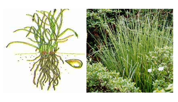 | Figure 10. Vetiver grass |
5. Conclusions & Recommendations
- The principal source of flooding is a result of flash flood originating from rainfall. It is formed as a result of intensive showers, sparse vegetation cover and steep slope of the area. Based on the sieve analysis test it is concluded that the majority of soil particle are well graded, however there is also an indication of poorly graded soil. Due to this reason, the use of vegetation as a bio-engineering tool for erosion control and slope stabilization is of utmost important. In our context, specially, Vetiver grass is very effective to control the effect of degradation effect due to its unique characteristics. The peak flood discharge is estimated using soil conservation curve number method (SCS-CN) and the average value and peak value of runoff are 9.94 mm and 33.9 mm respectively. In addition to this, the maximum runoff is found on Cambisol soils. Finally out of different types of river training structures, construction of Groyne and retaining wall are selected for controlling and regulating the river bed configuration for effective and safe movement of floods and river sediments.
5.1. Recommendations
- 1. Provisions must be made on the land-use policies of allocating the land for settlers because every year large amount of property has been damaged by floods.2. Case studies on the structural approaches of river training works must be made; because flood is a serious obstacle of the socio-economic development of the city of Dire Dawa. 3. River gauge observers must be assigned especially in flood prone areas to provide high risk real time information on river levels and possible flooding threats.4. The early warning information should be equipped with placement at essential corner of the city so as to alert the people from the flood.5. Integrated flood risk management strategies such as establishing trans-boundary flood management institution and integrated watershed management should be adopted in Dire Dawa city and its watershed to manage flood risks in sustainable manner.
ACKNOWLEDGEMENTS
- The Authors would like to acknowledge Dire Dawa University for providing fund for this research. We are also thankful to all the organizations who directly and indirectly helped us for the completion of this research.