-
Paper Information
- Paper Submission
-
Journal Information
- About This Journal
- Editorial Board
- Current Issue
- Archive
- Author Guidelines
- Contact Us
Science and Technology
p-ISSN: 2163-2669 e-ISSN: 2163-2677
2016; 6(1): 15-23
doi:10.5923/j.scit.20160601.03

Aquifer Vulnerability Assessment in Some Towns of Yenagoa, South-South Nigeria
 Abstract
 Reference
 Full-Text PDF
 Full-text HTML
Akana T. S.1, George G. C.2, Oki O. A.1
1Department of Geology, Niger Delta University, Nigeria
2Department of Physics, Niger Delta University, Nigeria
Correspondence to: Akana T. S., Department of Geology, Niger Delta University, Nigeria.
| Email: |  |
Copyright © 2016 Scientific & Academic Publishing. All Rights Reserved.
This work is licensed under the Creative Commons Attribution International License (CC BY).
http://creativecommons.org/licenses/by/4.0/

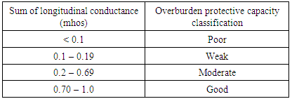
An assessment of aquifer protective capacity was investigated in some towns of Yenagoa. Fifteen (15) Vertical Electrical Soundings (VES) stations were occupied using the Schlumberger electrode configuration. The VES data interpretation involved quantitative modelling and the curve types obtained were HA, KHK, HK, AK, HKQ and KH. The modelled geoelectric parameters (layer resistivity and layer thickness) at each station were used to compute the Dar-zarrouk parameter (i.e. longitudinal conductance LC). Longitudinal conductance values showed areas with poor (less than 0.1 mho), weak (0.1 mho – 0.19 mho), moderate (0.2 mho – 0.69 mho) and good protective capacity (0.7 mho– 4.9 mho). Results showed that 53.3% of the area had a weak aquifer protective capacity, 33.3% had poor protective capacity and 13.3% had good and moderate aquifer protective capacity. The longitudinal unit conductance indicated that the Southern Yenagoa had good to moderate aquifer protective capacity rating, while the Northern area had poor to weak aquifer protective capacity.
Keywords: Aquifer Vulnerability, Resistivity, Dar-zarrouk parameters, Yenagoa
Cite this paper: Akana T. S., George G. C., Oki O. A., Aquifer Vulnerability Assessment in Some Towns of Yenagoa, South-South Nigeria, Science and Technology, Vol. 6 No. 1, 2016, pp. 15-23. doi: 10.5923/j.scit.20160601.03.
Article Outline
1. Introduction
- The rapid increase in population in Yenagoa owing to urbanization has led to an increased pressure on underground water which is the major water resource in the area. Groundwater quality has been affected by a number of factors such as over abstraction, movement of leachate to the aquifer from dumpsites, leakage of surface and underground storage and septic facilities e.t.c. The importance of potable water supply to human health cannot be over-emphasized, as such; one must take into consideration the quality of the geologic material overlying the aquifer. Henrit (1976) showed that the combination of layer resistivity and thickness can be used to compute the Dar Zarrouk parameters LC (longitudinal conductance) and RT (transverse resistance), which may be of direct use in aquifer protection studies and evaluation of hydrologic properties of aquifers. The protective capacity is considered to be proportional to the longitudinal unit conductance in mhos (Olorunfemi et al., 1998; Oladapo et al., 2004). A detailed geoelectric survey covering parts of Yenagoa was carried out to determine the geoelectric parameters of subsurface layers and their hydrogeological properties for the evaluation of the protective capacity of the aquifer overburden materials in the area.
2. Physiography and Geology of Study Area
- The study area is Yenagoa the capital of Bayelsa state. It lies within latitude 04° 4N and 05° 02N and longitude 006° 15E and 006° 24E (fig 1) and situated in southern part of the Niger Delta of Nigeria. The city lies within the tropical Equitorial climate with an annual mean rainfall of 3000 mm (Amajor and Ofoegbu, 1988). It is accessible by a good road network and tributaries of the river Nun. The average elevation of the study area is 10m above sea level. The area under study falls within the Niger Delta which is characterized by nearly flat topography sloping slightly seawards (Etu-Efeotor and Akpokodje, 1990). This area lies in the sedimentary basin of the Niger Delta and is devoid of any outcrop. During the rainy season, the area is flooded while it is dry during the dry season.
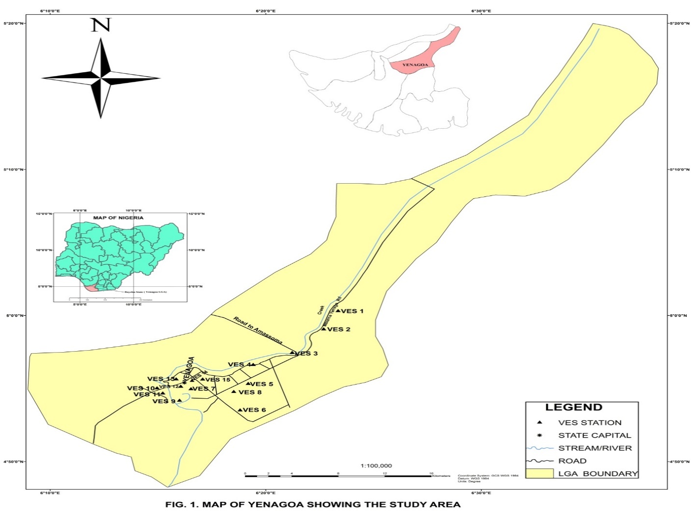 | Figure 1. Map of Yenagoa LGA showing the location of VES stations |
3. Materials and Method
- Investigation was done using the Vertical Electrical Sounding method (Schlumberger configuration) with a maximum current electrode (AB) spread of 200m – 266m. A total of Fifteen (15) VES stations were occupied (Fig 1). The ABEM terrameter SAS 1000 was used for data acquisition. The field procedure was carried out by applying current to the ground through two electrodes (A and B) and then measuring the resultant potential difference (ΔV) between the potential electrodes (M and N). The centre point of the electrode array remained fixed but the spacing of the electrodes was increased so as to obtain information about the stratification of the ground (Koefoed, 1977). The interpretation was computer assisted; some of these soundings were done at the sites of existing boreholes. Lithology and thickness of layers from these boreholes were used to constrain models. The combination of the resistivity and layer thickness was used to compute the Longitudinal conductance of layers (Golam et al., 2014; Oborie and Udom, 2014). High longitudinal conductance indicated relatively high protective capacity. The total longitudinal conductance (S) for each of geoelectric sounding (VES) stations was computed from the relation:
 | (1) |
|
4. Results and Discussion
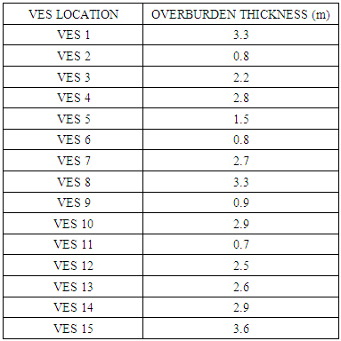
- The geoelectrical curves obtained (fig 2) vary considerably throughout the study area. Data analysis showed that the area under investigation was a four to five layered. Typical forms of the curves obtained are HA, HK, KH, AK, KHK and HKQ (Fig. 2). The top layer thickness and resistivity ranged between 0.42 m - 1.5 m and 15 Ωm – 48.8 Ωm respectively and consisted of weathered/dry organic rich peaty clay. The second layer thickness and resistivity ranged between 0.9 m - 15.0 m and 2.4 Ωm – 615 Ωm respectively. It consisted mainly of silty clay but on VES’s 6, 9 and 11 this layer consisted of medium-coarse grained sands. The third layer was chiefly medium - coarse grained sands with few clay lenses. This layer was observed to be the main water-bearing layer, resistivity ranged between 77 Ωm - 1960 Ωm with an average of 460 Ωm, its thickness ranged between 23.9 m – 48.7 m. The fourth layer in this study is mainly the half-space, it had an average resistivity of 3000 Ωm. VES 2 and 13 were five layer cases, they had a thickness that ranged between 32 m – 48 m, with resistivity range of 13 Ωm – 51 Ωm, typical of a clay/ silty clay formation.
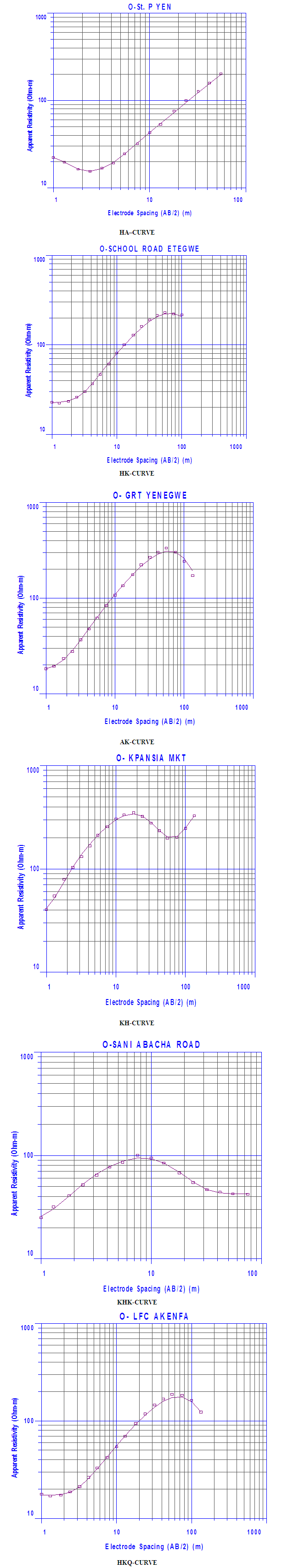 | Figure 2. showing Predominant VES curves |
|
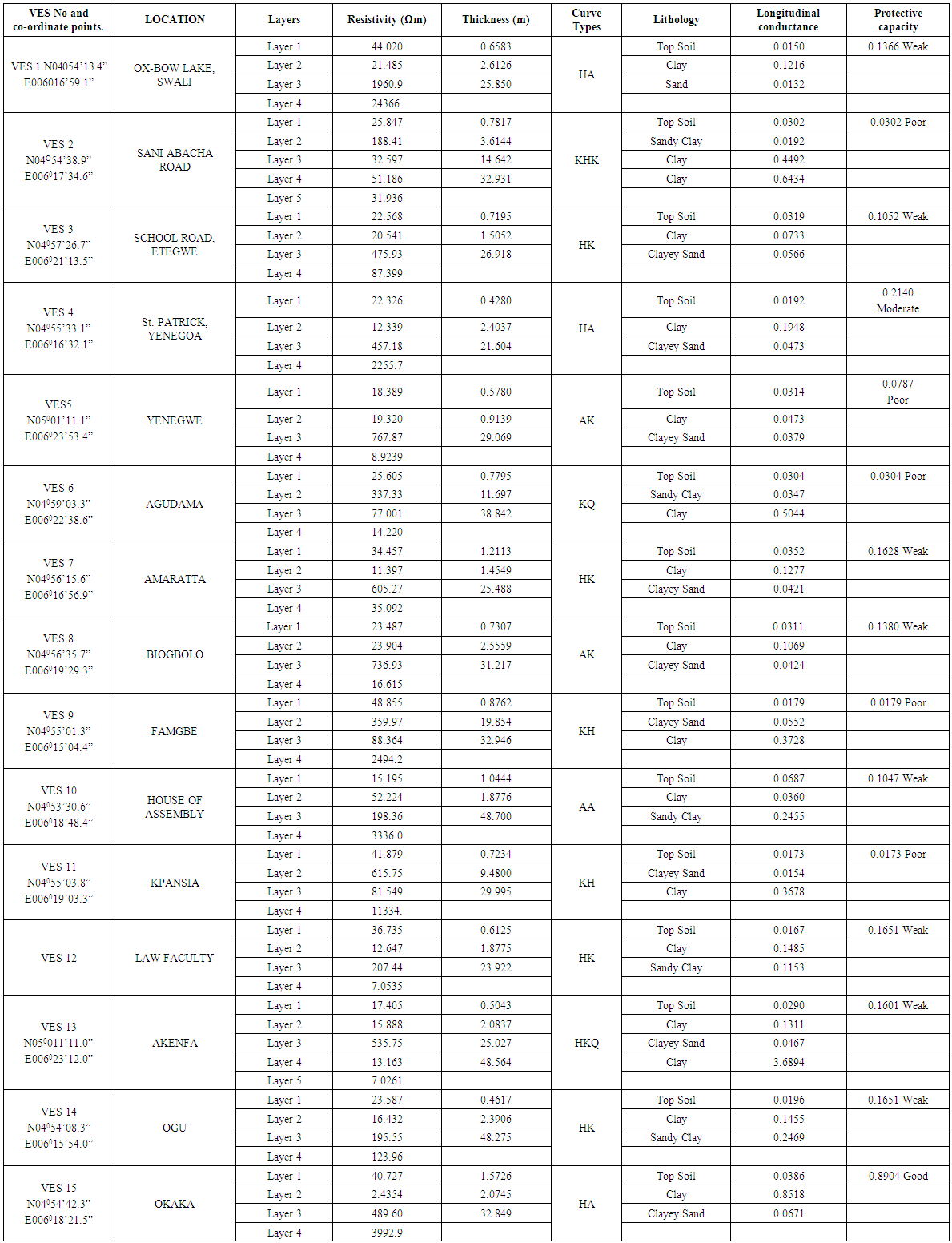 | Table 3. VES Coordinates Points, Geoelectric Parameters, Lithological Delineation and Protective Capacity |
5. Conclusions
- About 53.3% of the area showed weak aquifer protective capacity, 33.3% had poor protective capacity and 13.3% possessed moderate to good aquifer protective capacity. Geoelectric investigation by the analysis of the longitudinal unit conductance suggested that sections of the aquifer underlying the Northern parts of the area studied had poor to weak protective capacity, while, good to moderate protective capacity was observed in the Southern parts of the study area. It is thus recommended that sanitary landfill sites, underground storage and septic facilities be sited on the Southern parts of Yenagoa with better aquifer protective capacity, taking the direction of underground water flow into consideration.