Idowu Innocent Abbas
Department of Geography, Ahmadu Bello University, Zaria, 80001, Nigeria
Correspondence to: Idowu Innocent Abbas , Department of Geography, Ahmadu Bello University, Zaria, 80001, Nigeria.
| Email: |  |
Copyright © 2012 Scientific & Academic Publishing. All Rights Reserved.
Abstract
The learning conditions in schools are alarming with lack of teaching materials, overcrowded classrooms and generally run-down condition of many of the school buildings. In spite of the relative availability of data, educational data in Nigeria still suffers from the following issues relating to the quality and completeness: erroneously recorded and reported data, inconsistent coding systems for information on schools and teachers, prolonged periods between data collection and data release, poor school record keeping. The aim of this research was to develop a GIS database for private and public secondary schools in the study area so as to enable effective and efficient planning and management of these schools. The aim of the research was achieved through identification of private and public secondary schools in the study area, mapping the secondary schools in the study area, with some basic facilities, generating the attribute data of the public and private secondary schools and finally, creation of GIS database for schools. The attribute data was obtained through the administration of questionnaires to the schools. A satellite image of the study area was obtained using Google earth to derive the base map through the digitizing process. The coordinates of each school were obtained using a hand-held GPS receiver to geo code the schools on the base map. Finally, a GIS database was therefore created and the spatial and attribute data encoded and analysis carried out using Arc GIS 9.2 software. The result of the database provides the users with a working environment for data management and also allows efficiency query of information needed for school management.
Keywords:
GIS, Data Base, Facilities, Management
1. Introduction
Education is one of the most important factors in Nigeria’s quest to become one of the largest economies by the year 2020. However, with the recent state of education in Nigeria, measures need to be taken to overhaul the system in order for it to serve as a reliable and efficient vehicle for the attainment of the vision. Secondary education is a program of public education immediately following elementary schooling. It begins generally at the age of 12 to 14 and continues for four to six years. Some secondary education, such as vocational schooling, is terminal and prepares the student for employment upon graduation. Others lead to advanced training in colleges, universities, or technical schools (Encarta, 2009).According to Encarta (2009) public school is an elementary or secondary school controlled and maintained by civil authority, acting through official board expending public money, and open to all local children. Public schools include grade or grammar schools, junior and senior high school, and vocational schools. Private school is program of instruction that is created and controlled, operated, and principally financed by private individuals and groups rather than by government. Unlike public elementary and secondary schools, which are free, nearly all private schools charge some form of tuition.Geographic information system (GIS) is a system of hardware, software, and procedures to facilitate the management, manipulation, analysis, modeling, planning and management of resources (NCGIA, 1991). It is also a “system for management, analysis, and display of geographic knowledge, which is represented using a series of information set such as maps and globes, geographic data sets, processing and work flow models, data models, and meta data” (ESRI, 2004). In terms of economic, an implementation of GIS will enhance the outcome for school analysis as well as application development (Hoxby, 2000).A GIS database for private and public secondary schools in Zaria and environs will be of great importance to the state government as well as the cooperation of all Nigerians, non- governmental organization and private sector in achieving objectives of education.It is extremely important to access the facilities through the use of a GIS database. With this database there is a potential to improve efficiency of schools through the planning and management of resources and the display of geographic knowledge. Analysis from the database can be carried out in several significant ways.A GIS database created can assist the present government in proper distribution of schools, improve the existing infrastructure and provide additional infrastructure for planning and management of educational resources. The research will enable us to know the spatial and temporal distribution of private and public Secondary schools in the study areaThe aim of this research is to map and develop a GIS database for private and public secondary schools in Zaria and Sabon Gari local government areas of Kaduna state.The above aim was achieved through the following objectives:Identification of private and public Secondary Schools in Zaria and Sabon Gari Loal Government Areas.Mapping the private and public Secondary Schools in the study area.Mapping the private and public secondary schools in the study area with some basic facilities.Generate the attribute data of the private and public Secondary Schools.Creation of GIS database for private and public Secondary Schools.The scope of this research covers Zaria and Sabon Gari Local Government areas of Kaduna State. The spatial extent of the research covers Zaria City, Gelesu, Sabon Gari, Samaru, Palladan, Basawa, Gaskiya and Tudun Wada. The temporal extent of the study covers private and public schools as at 2011. The knowledge extent of the research covers identification, mapping, and generating of database about the private and public secondary schools in the study area.This study makes available a comprehensive database for efficient management of private and public Secondary Schools in Zaria and Sabon Gari Local Government Areas. A digital map of the study area will also be produced which presents the picture of the Schools at a glance and ensure updating.The study area is located between latitude 11° 15/ N and 11° 3/ N of the equator and longitude 7° 30/ E and 7° 45/ E of the Greenwich meridian. It is situated in Kaduna state of Nigeria. The area is bounded to the North by Funtua Local Government of Katsina State, to the West by Birnin Gwari Local Government Area, while to the East and South-East by Ikara and Lere Local Government areas of Kaduna State respectively The region transverse about 70Km from the West to East and roughly covers 8,950 square kilometer. The area include; Samaru, Palladan, School of Aviation, Basawa, A.B.U, Kubani Dam and around Kubani, River Galma, Sabon Gari, Zaria city and Kongo This study was restricted to Urban Zaria and Sabon Gari Local Government areas as defined by Mortimore (1970).The settled population in Zaria and Sabon Gari was predominantly Hausa and Fulani. According to the 1991 population census, the population of Zaria and Sabon Gari were 248,318 people. The density of population ranges from 50-200 persons per square kilometer, the heaviest population concentration was found in Sabon Gari and Samaru (NPC, 2006).
2. Data and Methodology
A trip was made to schools in the study area and coordinates of each school were obtained using the Germin 75S Handheld GPS Receiver. A trip was also made to the schools for the administration of questionnaires. The questionnaires contain data such as school name, year of establishment, number of teaching and non teaching staff, number of students in each class (JSS 1 to SSS 3), number of classrooms in each class (JSS 1 to SSS 3). These data are useful for various types of analysis which will greatly assist in the efficient and effective planning and management of school resources.The digital base map was obtained by digitizing Google Pro 2008 satellite image. A list showing the private and public secondary schools in the study area was obtained from the state Ministry of Education.In digitizing the feature classes, the Google satellite image was used to map the features classes. First, it was downloaded from the internet so that the satellite image could be seen for accurate mapping. The digitizing exercise then started by adding the layers that were created in Arc Catalog. The start editing was activated in the editor tool and features classes were digitized by selecting the “create New Features” in the Task drop-down menu. The pencil icon was clicked and the pointer becomes a small crosshair symbol. A homogeneous area was picked and the vertices of the polygon were created by “tracing” the boundary and clicking at each vertex.
2.1. Database Creation
The following data were collected and used in the development of the database. They are: i. Satellite image showing the study area ii. Schools control points. iii. List showing school names and addressesiv. Questionnaires administered to schools in the study areaAll the necessary information for each school was entered into its layer’s attribute table and stored for analysis. This was done by adding required number of fields (columns) to the table and entering the data for all the schools in their corresponding records (rows).
2.2. Plotting the Coordinates
The coordinates of the schools were copied in notepad and saved as a .txt (plain text) file format. The coordinate used is shown in table 1.The following steps were taken to import the files into Arc Map: ● In the main bar “tools” was right – clicked, a dialog box appeared and the “Add XY Data” was selected.● The “Add XY Data” window appeared and the browse to folder button was clicked. The folder in which the school coordinates file was saved was browsed and added.● The filed for the X and Y coordinates (i.e. easting and northing) were specified and the coordinate system of the input coordinate was selected, applied and ok.● The locations of the schools were automatically added to the map as points.| Table 1. Coordinates used to Geo-reference the Satellite Image |
| | Land Mark | Easting | Northing | | M1 | 357041.4 | 1247358.54 | | M2 | 374016.48 | 1220834.28 | | M3 | 356832.56 | 1236460.43 | | M4 | 339768.44 | 1236460.43 | | M5 | 357716.06 | 1231358.04 |
|
|
3. Results and Discussion
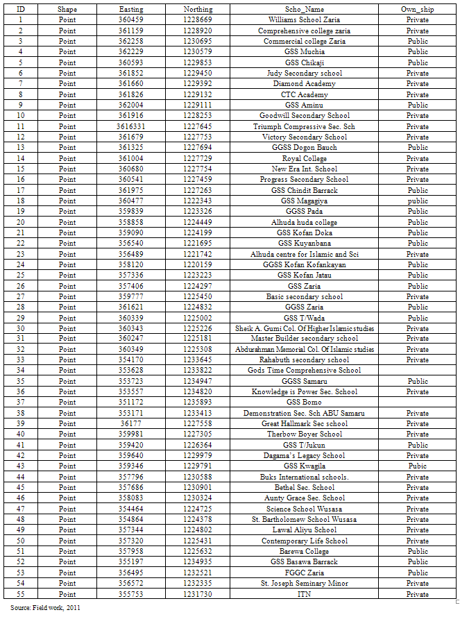
To achieve the objective of Identifying and mapping the private and public secondary schools in the study area, table 2 and figure 1 were produced.Table 2 shows the list of private and public secondary schools in the study area. From the table, it can be seen that a total of 55 secondary schools were in the study area with a total of 31 being private while the remaining 24 were public schools. The table also contains the names of the schools and their geographical locations. The geographical distribution of the schools is also shown in figure 1.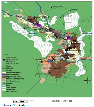 | Figure 1. Spatial distribution of the secondary schools in the study area |
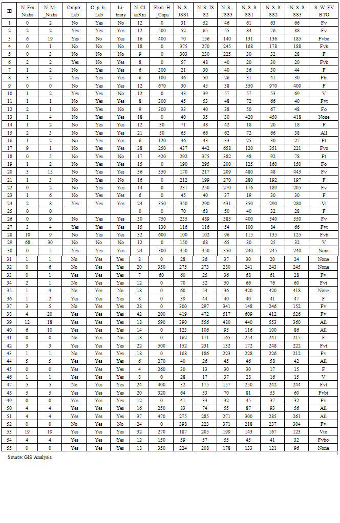
A GIS Database for the Secondary Schools in Zaria and Sabon-Gari LGAs was created as shown in table 3 after the information collected through the use of questionnaire were incorporated with the information in table 2. Queries of some basic facilities from the database created were done and the resultant results are shown in figures 2 to 5.Query operations were performed on the database created and the results show that 20 (36%) schools out of 55 schools had library, computer, chemistry, physics, and biology laboratories while the remaining 35 (64%) schools did not have all the facilities as shown in figure 2; out of 55 schools, 25 schools which represent about 45% of the total number of schools had examination hall with capacity ≥250, while 53.36% had <250 or none from table 3 and figure 3; that there were 41 schools which represent 73.21% of the total number of schools in the study area that had the total number of classes > 12, while about 25% had as shown in table 3 and figure 4 less than 12 classes; the buffer of 2km was performed which shows that most of the schools were within a distance of 2km from residential areas as shown in figure 5 and table 3 except for Unguwan Abashi and Zabi Zaria that did not have schools close to them so the students had to travel more than 2km to the nearest school to them. Table 3 also shows the number of students in JSS1, JSS2, JSS3, SSS1, SSS2 and SSS3 in each of the schools. More so, it indicates the schools with some basic facilities such as football, volley ball, basket ball and tennis.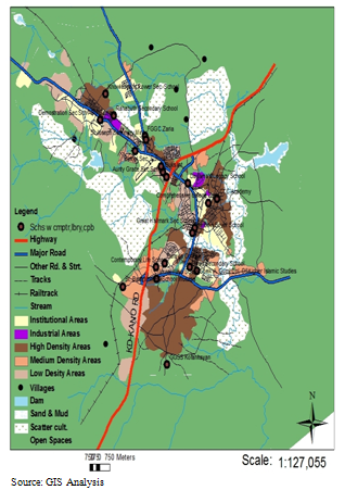 | Figure 2. Distribution of Schools having library, Computer, Chemistry, Physics and Biology Laboratories |
Table 2. List of Private and Public Secondary Schools in the Study Area
 |
| |
|
Table 3. A GIS Database for Private and Public Secondary Schools in the Study area
 |
| |
|
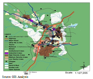 | Figure 3. Schools with examination hall of capacity ≥ 250 students |
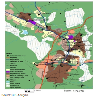 | Figure 4. Distribution of Schools Having Number of Classes ≥ 12 |
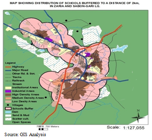 | Figure 5. Distribution of Schools Buffered to a walking distance of 2km |
4. Conclusions
The learning conditions of most schools in the study area has shown that governments, non-governmental organizations, private sectors and the communities should support the educational sector through the provision of learning facilities most especially in those schools that lack facilities in order to assist the nation to attain its educational objective. The use of GIS in school data handling should be encouraged especially as it assists in carrying out various analyses which can indicate where these facilities are inadequate, lacking or not properly distributed. This makes decision making easier and also enhance the proper distribution of these facilities.The aim of this project has been achieved by mapping and creating a GIS database of public and private secondary schools in Zaria and Sabon Gari Local Government areas has been developed using Arc GIS 9.2 software. The database provides the users with a working environment for data management. It also allows efficient query of information needed for school processing. The result of the research carried out has shown that most of the schools are concentrated in Sabon Gari areas while Kuregu and Ungwan Abashi did not have Secondary Schools at all. This research goes to strengthen the importance of GIS in mapping and data base creation.Abbreviations Used in Database1. Sch_Name: School Name2. Sch_Addres: School Address3. Sch_Cat: School Category4. Own_Ship: Ownership5. Yr_of_Estb: Year of Establishment 6. N-M_Tchr: Number of Female Teachers 7. N_Fm_Tchr: Number of Male Teachers8. N_M_Ntchs: Number of Male Non_teaching Staffs9. N-Fm_Ntchs: Number of female non teaching staffs 10. N_MS_JSS1: Number of Male Students in JSS111. N_Fms_JSS1: Number Of Femlae Students in JSS212. N_MS_JSS2: Number of Male Students in JSS213. N_FmS_JSS2: Number of Female Students in JSS214. N_MS_JSS3: Number of Male Students in JSS315. N_fmS_JSS3: Number of Female Students in JSS316. N_MS_JSS1: Number of Male Students in SSS117. N_FmS_JSS1: Number of Male Students in SSS118. N_MS_JSS2: Number of Male Students in SSS219. N_FmS_JSS2: Number of Female Students in SSS220. N_M_SSS3: Number of Male Students in JSS321. N_FmS_JSS3: Number of Female Students in SSS322. Cmptr_Lab: School with Computer Lab23. C_P_B_Lab: School with Chemistry , physic, and Biology Lab24. Library: School with Library25. N_ClasRm: Total Number of classroom 26. S_W_Fvtb: School with Football, Volleyball, Tennis, Basketball, and other Sport Facilities27. N_MS_LJSCE: Number of Male Students that sit for the last JSCE28. N_FS_LJSCe: Number of Female Students that Sit for the last JSCE29. JSCE_4c_M: Male Students that passed JSCE with 4C and above30. JSCE_4C_FM: Female Students that passed JSCE with 4C and above31. N_MS_LSSCE: Number of Male Students that sit for the last SSCE 32. N_FmS_LSSC: N_MS_LESSCE: Number OF Female Students that sit for the last SSCE33. N_MS_LSSCE: Number Of Male Students That Sat For The Last SSCE34. N SSCE_5C_M: Male Students That passed SSCE with 5C above35. SSCE_5C_F: Female Students that passed SSCE with 5C and above
References
| [1] | Amazon (2009). Garmin GPS Map 76S Handheld GPS. [Online] Available at www.Amazon.com, Accessed on, 27th December, 2009. |
| [2] | Encarta (2009). Private/Public School. USA: Microsoft Incorporation. |
| [3] | ESRI (2004), GIS Getting Started. [Online] Available at http://www.esri.com/getting_started/inDe.html, Accessed on, 12 May, 2009. |
| [4] | Hoxby, (2000), Geographical Information Systems in Britain: In Wrigley, N. and Bennett, R. J.(eds) Quantitative Geography. |
| [5] | Mortimore, M. J (1970), “Zaria and its Region” Department of Geography, Ahmadu Bello University, Zaria. Vol. 4 |
| [6] | National Population Commission (2006), Nigerian Demorgraphic and Health Survey 2006, Clalverton Marryland, NPC. |
| [7] | NCGIA (1991), What is GIS: Definition of GIS. [Online] Available at http://www.geomaics /GIStheory.htm, Accessed on, 4th Match, 2009 |
| [8] | Norman, D.W (1970), Rural Economy with special Reference to Agriculture in Mortimore, M. J (eds), Zaria and its Region, Department of Geography, ABU, Zaria. |


 Abstract
 Reference
 Full-Text PDF
 Full-Text HTML
