-
Paper Information
- Paper Submission
-
Journal Information
- About This Journal
- Editorial Board
- Current Issue
- Archive
- Author Guidelines
- Contact Us
Resources and Environment
p-ISSN: 2163-2618 e-ISSN: 2163-2634
2019; 9(1): 1-8
doi:10.5923/j.re.20190901.01

The Erosion Hazard Risk on Several Land Uses in the Rassasisi Sub-watershed of the Rongkong Watershed, North Luwu Regency, Indonesia
 Abstract
 Reference
 Full-Text PDF
 Full-text HTML
Annas Boceng1, Soemarno2, Sukoso3, Amir Tjoneng4
1Study Program of Environmental Sciences, Brawijaya University, Malang, Indonesia
2Faculty of Agriculture, Universitas Brawijaya, Malang, Indonesia
3Faculty of Fisheries and Marine Science, Universitas Brawijaya, Malang, Indonesia
4Faculty of Agriculture, University of Muslim Indonesia, Makassar, Indonesia
Correspondence to: Annas Boceng, Study Program of Environmental Sciences, Brawijaya University, Malang, Indonesia.
| Email: |  |
Copyright © 2019 The Author(s). Published by Scientific & Academic Publishing.
This work is licensed under the Creative Commons Attribution International License (CC BY).
http://creativecommons.org/licenses/by/4.0/

The Rongkong watershed is an area in which most of the local community works as farmers in North Luwu Regency Indonesia. The use of the surrounding land by the local community is as agricultural land. This usage may give benefits to the local community. However, it is necessary to avoid the risk of land damage due to erosion. An intensive land use potentially increases the erosion of value if it does not heed to the conservation measures, so that the risks of land damage due to erosion, such as environmental pollution, floods, landslides and many more are likely to be occurred, therefore it is needed to know the value of erosion, a study was conducted on the index analysis of erosion hazard in the sub-watershed of the Rassasisi in the upstream of the Rongkong watershed. This study aims to analyze the tolerable soil loss (TSL) and to find out the Erosion Hazard Index (EHI) in various of land use types in the Rassasisi sub-watershed. This research was conducted in Rassasisi sub-watershed in the upstream of the Rongkong watershed in North Luwu Regency, Indonesia from July to September 2017. To determine the land units in the research location, several maps were used, they were: soil map, slope map and land use map. The data were overlaid by using the Arc GIS 9.3 program to obtain 54 units of land. The results showed that the tolerable soil loss (TSL) varies between the land use types. The highest tolerance value was found in primary forest with the score was 57.04 tons / ha / year, followed by mixed garden land (55.2 tons / ha / year), the shrub (49.68 tons / ha / year), and secondary forest was 49.68 tons / ha / year. The erosion hazard index was also varied among the land use types. The lowest value was found in primary forest with the score was 0.01 followed by secondary forest (0.33), mixed garden land (11.30), the shrub (36.43). Therefore, this study suggests that the land use type of mixed garden land was recommended for the local community because it have had a lower risk than the shrub.
Keywords: Erosion, the tolerable soil loss, the Erosion Hazard Index, Sub-watershed, Land use, Land units
Cite this paper: Annas Boceng, Soemarno, Sukoso, Amir Tjoneng, The Erosion Hazard Risk on Several Land Uses in the Rassasisi Sub-watershed of the Rongkong Watershed, North Luwu Regency, Indonesia, Resources and Environment, Vol. 9 No. 1, 2019, pp. 1-8. doi: 10.5923/j.re.20190901.01.
Article Outline
1. Introduction
- The Rongkong Watershed is a watershed located in North Luwu Regency. This watershed is used for irrigation and other needs of the local community. The Rongkong watershed consists of primary forests that was 40.96%, secondary forests 10.88%, and mixed gardens 23.99% of the Rongkong watershed area. Agricultural land consisting of dryland and wetland (agriculture) was 10.25% (19,463.26 ha), mixed gardens covering 45,764.18 ha (23.99%), the inundated condition of Rongkong watershed reaches 11,695, 33 ha (6.13% of the area of Rongkong watershed). Other closures of the Rongkong watershed area were settlements, shrubs and open land [1].If the intensive land use does not pay attention to conservations and its management, it will potentially cause the erosion hazard such as: environmental pollution, floods, landslides and siltation in the downstream area. An alternative that can be done to reduce the occurrence of erosion is the regulation of the land maintenance pattern by intercropping certain plants with mounds given organic fertilizer [2]. The treatment is significantly able to reduce the amount of erosion and surface runoff to be smaller than the other land maintenance techniques and be the most demanded technique by farmers.The results of a study showed that the physical properties of soil were the dominant factors that determined the level of erosion in coffee-based farming land in Sumberjaya. Soils with the average porosity of >65% with macro pores >24% and soil permeability >9 cm-1 hour, the erosion that has occurred for 3 months reaches 37 t ha-1 [3]. In addition, disaster management efforts can also be carried out in a non-structural manner, meaning in the form of non-physical development, yet in the form of non-physical actions, for instance, making erosion hazard maps, demonstrating the early warning systems, public information and counseling, and spatial planning [4]. In line with that, it was suggested that watershed management can be viewed from a physical and institutional perspective, so that watershed management and policies are not only based on physical indicators, yet their success is strongly supported by the existence of coordination, integration, synchronization and synergy [5].Therefore, it is important to know the level of erosion. Regarding to this issue, a study of erosion hazard analysis was carried out in the upstream of the Rassasisi sub - watershed of Rongkong watershed.In Rongkong watershed, several problems were identified, namely critical land, erosion, sedimentation, land use outside the status of the area or outside its functions (land conversion), social problems, and institutions. Critical land reaches 34,206.39 ha with critical conditions covering the area of 30,424.52 ha and very critical conditions covering the area of 3,781.87 ha; and rather critical conditions covering the area of 74,294.21 ha and a critical potential conditions covering the area of 69,953.22 ha. Meanwhile, the conversion of land was 16,218.70 ha. [6].The most visible phenomenon in Rongkong watershed is the frequent overflow of water in the central areas of human activity, which often has a negative impact on humans both directly and indirectly. Erosion brings a surface layer of soil that is generally most fertile, rich in organic material and nutrients, thus it causes the loss of nutrients for plants [7]. Regarding to this reason, in the context of development in Rongkong watershed, data and information is needed regarding the amount of total erosion, average erosion or the rate of erosion increase and the magnitude of the Erosion Hazard Index. This study aims to analyze the tolerable soil loss (TSL) and to find out the Erosion Hazard Index (EHI) in various of land use types in the Rassasisi sub-watershed.
2. Research Methods
2.1. Place and Time
- This research was conducted in Rassasisi sub-watershed in the upstream of the Rongkong watershed in North Luwu Regency, which runs from July to September 2017.
2.2. Materials and Tools
- The materials used in this study were watershed, soil, land use, and slope maps of each with a scale of 1: 100,000 obtained from the Watershed Management Center and rainfall data from the Meteorology and Geophysics Agency of South Sulawesi Province.
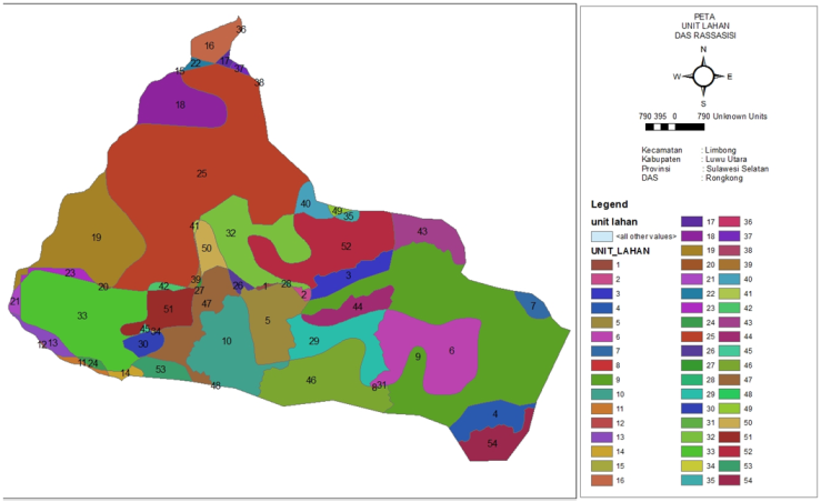 | Figure 1. Land unit map of the Rassasisi watershed as the research location |
2.2. Research Methods
2.2.1. Land Unit Determination
- To determine the land units in the research location, several maps were used, they were: soil map, slope map and land use map. The data were overlaid by using the Arc GIS 9.3 program to obtain 54 units of land.
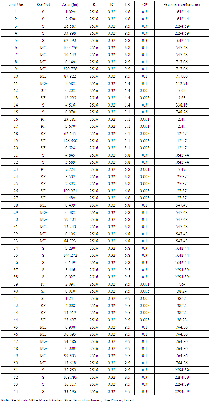
2.2.2. Determining Erosion Rate
- The general equation that was used in this study to estimate the magnitude of erosion was the general equation of soil loss using Wichmeier Method (1978) or USLE [8].A = R K L S C P
2.2.3. Rain Erosivity
- Factors of Rainy Erosivity are obtained from the Lenvain equation [9]. These obtains a relationship between all 30 and annual rainfall (R) as follows:
 | (1) |
2.2.4. Soil Erodibility
- Soil erodibility factors, determination of soil erodibility value developed by [8] Wischmeier and Smith (1978) by using homographs which are based on soil properties influencing it, include the texture, soil structure, organic material content and soil permeability [10].
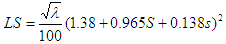
2.2.5. Topographic Conditions
- Factors of length and slope, the determination of slope factors, namely the length of slope (L) and slope (S), were calculated together. The LS value of a land can be calculated by the following equation [11]:
 | (2) |
2.2.6. Land Management
- Land or Plant Management Factors. This factor is determined by the value of plant factors and the management or pattern of plants in a year of planting.
2.2.7. Conservation Action
- Soil Conservation Measures were based on P factor values for a variety of special soil conservation [11].
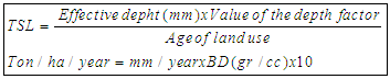
2.2.8. Tolerable Erosion
- Tolerable Soil Loss (TSL) model or erosion that can be tolerated was determined by using the equation as follows [12].
 | (3) |
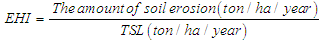
2.2.9. Erosion Hazard Index
- Calculating the magnitude of the Erosion Hazard Index used the equation as follows [13].
 | (4) |
3. Results and Discussion
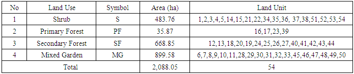
3.1. Land Unit Analysis
- Based on the overly results of land use map, slope map and soil map in Rassasisi sub-watershed in the upstream of Rongkong watershed, there were 54 units of land as in Figure 1. The classification of land units based on land use is presented in Table 1, while erosion value of each land unit is presented in Table 2.
|
|
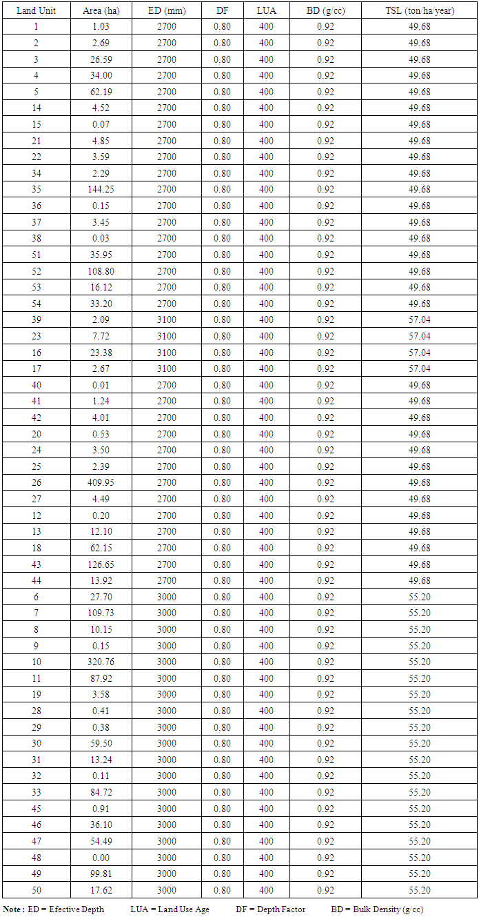
3.2. Tolerable Erosion
- The value of Tolerable Soil Loss (TSL) or the tolerable erosion rate was calculated according to the Hammer method [14]. This value was traced based on the effective depth (mm) of the soil suborder, the value of the depth factor and the age of land use. Tolerable erosion rate values and various land uses are presented in Table 3.
|
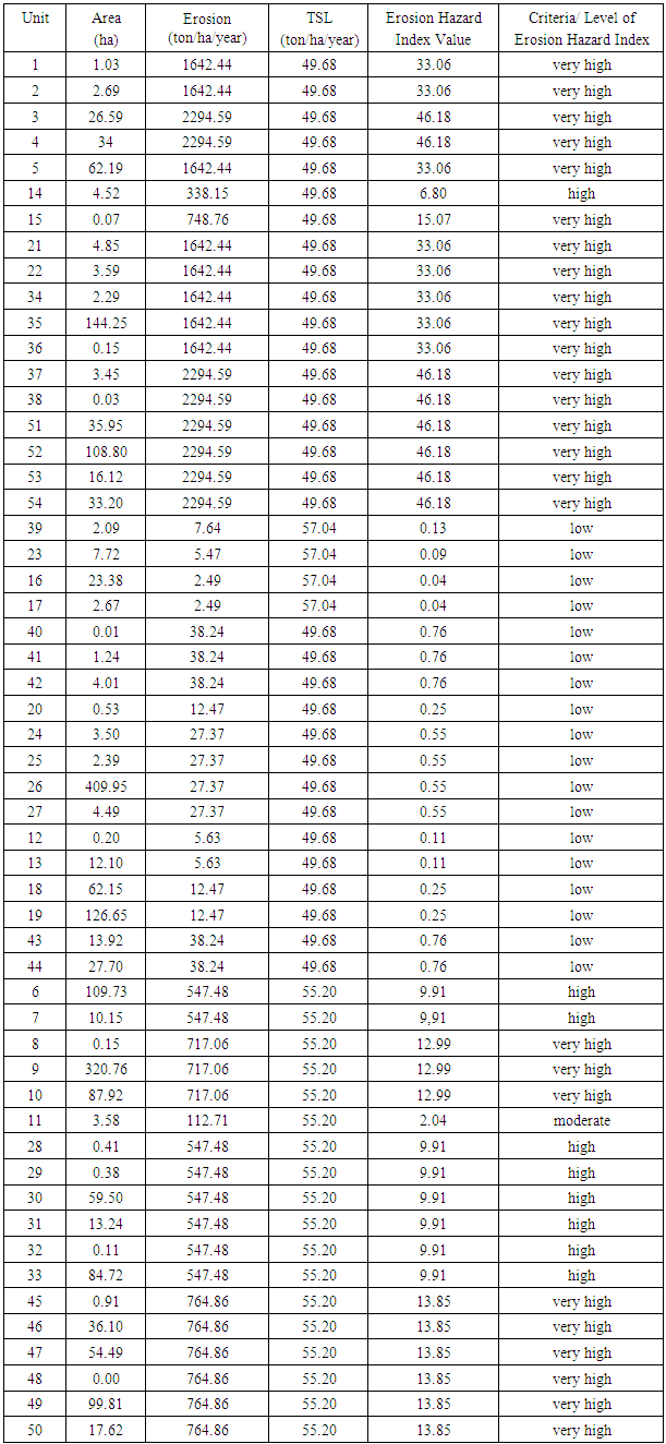
3.3. Erosion Hazard Index
- Based on tolerable erosion and erosion values, the erosion hazard index criteria were calculated according to the Hammer method [12]. The criteria were traced based on the tolerable erosion and erosion values of various land uses in Rassasisi watershed, the criteria for the average of the erosion hazard index and the calculations are presented in Table 4, and the erosion hazard index map is presented in Figure 2.
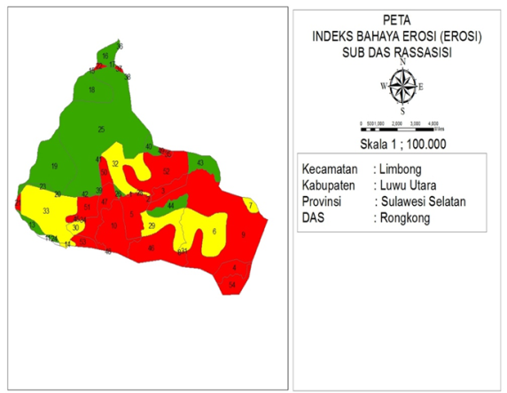 | Figure 2. Erosion hazard index map of in rassasisi sub-watershed |
|
4. Conclusions
- The highest tolerance value was found in primary forest with the score was 57.04 tons / ha / year, followed by mixed garden land (55.2 tons / ha / year), the shrub (49.68 tons / ha / year), and secondary forest was 49.68 tons / ha / year. The erosion hazard index was also varied among the land use types. The lowest value was found in primary forest with the score was 0.01 followed by secondary forest (0.33), mixed garden land (11.30), the shrub (36.43).
5. Suggestion
- The management of mixed garden should practice the soil conservation techniques such as planting crops, according to contour directions and making terraces or replacing them with forest plants such as sengon (Albizia chinensis) and teak. Shrub land management is used as reforestation land, while protecting secondary and primary forests should be a conservation priority.