Resources and Environment

p-ISSN: 2163-2618    e-ISSN: 2163-2634

2018;  8(3): 164-173

doi:10.5923/j.re.20180803.08


Towards Sustainability of Carpathian Urban Heritage in Spatial Planning– Cases of Slovak, Polish and Czech Historic Towns

Wiktor Głowacki, František Imrich

National Institute for Spatial Policy and Housing, Kraków, Poland

Correspondence to: Wiktor Głowacki, National Institute for Spatial Policy and Housing, Kraków, Poland.

Email:

Copyright © 2018 The Author(s). Published by Scientific & Academic Publishing.

This work is licensed under the Creative Commons Attribution International License (CC BY).
http://creativecommons.org/licenses/by/4.0/

Abstract

In the following paper we analyse heritage related regulations of local spatial plans of Štramberk in Czechia, Bardejov in Slovakia and Dukla in Poland and we compare them to relevant Carpathian Convention documents with particular emphasis on the concept of Carpathian Heritage Inventory. We conclude that there is a high level of convergence between the contents of urban plans and recommendations of the Convention. Therefore, if implemented, the Carpathian Heritage Inventory should be made carefully with respect to existing inventories of different levels in order to use them rather than duplicate.

Keywords: Urban planning, Carpathians, Cultural heritage

Cite this paper: Wiktor Głowacki, František Imrich, Towards Sustainability of Carpathian Urban Heritage in Spatial Planning– Cases of Slovak, Polish and Czech Historic Towns, Resources and Environment, Vol. 8 No. 3, 2018, pp. 164-173. doi: 10.5923/j.re.20180803.08.

1. Introduction

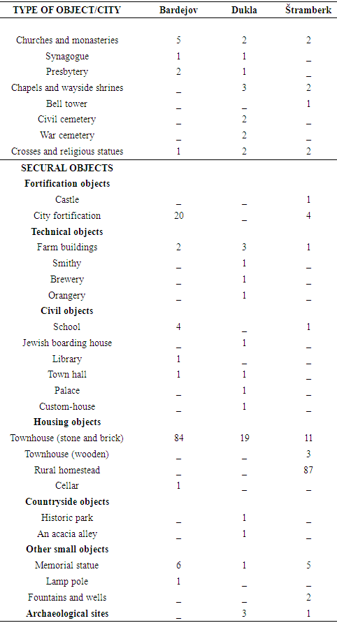
Planning systems of Czechia, Slovakia and Poland are usually considered a part of the Eastern European legal family [Knieling, Othengrafen 2009] mainly due to their common communist past until 1989. After 1989 problems related to political and economic transformation from socialist to market economy dominated urban development in Central Europe [Sjöberg 2014]. Terms “post-communist” or “post-socialist” became a sort of “label” of cities in the region.
Simultaneously efforts have been made on local regional and national levels to safeguard by means of spatial planning those environmental and cultural values that exist regardless of communist legacy. International efforts in this field have led to the signing of Carpathian Convention [Conference of Plenipotentiaries for Adoption and Signature of the Framework Convention on The Protection and Sustainable Development of the Carpathians 2003] subsequently countries–parties prepared a few more specific documents in order to outline common policies. As regards cultural heritage Recommendations on creating of the Carpathian Heritage Inventory [The Northern Alliance for Sustainability 2011] were elaborated in years 2007-2011 on the basis of research carried out in Czechia and in Ukraine. They were intended to help to protect and develop cultural heritage in the whole Carpathian region. Five principles of the inventory were formulated in the end of recommendations: diversity; non-elite selection; balance between tangible and intangible heritage; authenticity and appropriateness; objectivity. Simultaneously local authorities have made their local spatial plans according to planning and heritage legislation of each country [Ustawa z dnia 27 marca 2003 r. o planowaniu i zagospodarowaniu przestrzennym 2003] [Ustawa z dnia 23 lipca 2003 r. o ochronie zabytków i opiece nad zabytkami 2003] [Zákon z 27. apríla 1976 o územnom plánovaní a stavebnom poriadku 1976] [Zákon z 19 decembra 2001 čís. 49/2002 Z.z. o ochrane pamiatkového fondu 2002] [Zákon ze dne 14. března 2006 o územním plánování a stavebním řádu 2006] [Zákon České národní rady ze dne 30. března 1987, o státní památkové péči 1987]. In this paper we compare the contents of local spatial plans in three Carpathian towns to the above principles.
Case Towns and their heritage in Settlement Structures of Czechia, Poland and Slovakia
Three Carpathian towns have been selected for the purpose of the research: Bardejov, Dukla and Štramberk. Bardejov with 33 296 inhabitants in 2014 is the biggest in the group. It is a centre of a district level administrative unit called okres which corresponds to NUTS4 level. Dukla with 2128 inhabitants in 2014 and Štramberk with 3418 inhabitants in 2014 represent both the municipal level which corresponds to NUTS5 level. The geographical location of case towns is shown on the map below.
Figure 1. The location of case towns (source: map by F. Imrich)
Significant internationally known cultural heritage resources were main reasons for the selection of case towns. The importance of the heritage of each town is reflected in its position on international and national heritage lists. The historic centre of Bardejov is listed among UNESCO World Heritage Sites since 2000. Urban Monument Reserve has been established in the centre of Štramberk in 1951. The old town of Dukla in Poland as a whole has not been formally declared a monument. However its 10 historic buildings on Polish national list of monuments and 33 items on municipal list provides the evidence of rich heritage resources of this small town. All three towns have one common characteristic in their urban history. They had developed for ages as trade cities on trade routes between southern and northern slopes of Carpathians. Simultaneously each of town has in its history different unique events that made them internationally known regardless of their previous past. Bardejov due to mineral springs in its vicinity became a famous spa centre in the 18th century. The discovery of bones of pre-historic Neanderthal child in Šipka cave in 1880 had brought an international fame to Štramberk. Dukla with its surroundings was a scene of a heavy battle in September and October 1944 between Soviet and Czechoslovak armies on one side and German and Hungarian armies on the other. The death-tool of the battle reached about 200 000 people.
Research on case towns started long ago. Janota (1862) published the first urban monograph of Bardejov in 1861. More recently the protection and management of the heritage of Bardejov has been a subject of detailed plans [Škrovina 2012], case studies [Harčar 2012] [Soročinová, Soročin 2012] and professional papers [Šarišský 2001], [Dvořáková 2012], [Ličkova 2012].
The monograph of Dukla was published in 1903 [Swieykowski 1903]. WWII heritage dominates in recent publications about this town [Wróblewski et al. 2004].
Geologists had known Štramberk quite well [Ogilvie 1897] when Bělohlav [1913] wrote its monograph. Recent research concerns the attitude of inhabitants and local authorities [Walterová 2011] as well as visitors [Kittlerová 2015] to the urban regeneration.
Now case towns face similar developmental problems related to the protection and management of outstanding heritage resources. All case towns have recently adopted local spatial plans [Fusková et al. 2013], [Szlenk-Dziubek et al. 2005], [Žiaran et al. 2007] in accordance with their national legislations [Ustawa z dnia 27 marca 2003 r. o planowaniu i zagospodarowaniu przestrzennym 2003], [Ustawa z dnia 23 lipca 2003 r. o ochronie zabytków i opiece nad zabytkami 2003], [Zákon z 27. apríla 1976 o územnom plánovaní a stavebnom poriadku 1976], [Zákon z 19 decembra 2001 čís. 49/2002 Z.z. o ochrane pamiatkového fondu 2002], [Zákon ze dne 14. března 2006 o územním plánování a stavebním řádu 2006], [Zákon České národní rady ze dne 30. března 1987, o státní památkové péči 1987] policies and guidelines [Glos et al. 2006].
Bardejov is best known internationally among case towns due to its inscription on UNESCO World Heritage List. Municipality of Bardejov prepared Management Plan of the World Heritage Site 2013 2020, Historic Center of the Town of Bardejov in 2013 in order to protect and to make accessible unique values of this town [Gembešová et al. 2013]. Town authorities realized the importance of the social perception of the heritage protection issues. Therefore two surveys were carried out in July and August 2012 as a contributions to this plan. The survey of public attitudes to the cultural heritage was carried among 362 inhabitants and visitors whereas 254 owners and users of buildings responded to the second survey on the opinion about World Heritage Site Bardejov. [Kilián, Vol’anská 2013]. The owners and users survey revealed that about half of them do not have sufficient knowledge about the type of protection of historic buildings they own and use. Generally owners and users reported monument protection as a problematic issue related to the real estate. Simultaneously more than a half of owners and users declared that their buildings have no deficiencies. The rest of them complained about bad structural and technical conditions of the building about inadequate size setup and design as well as about a location of the building that does not allow for the desired use of building. Owners and users reported scarcity of financial resources as a major problem of restoration. About 88% of them did not receive any financial support from The Ministry of Culture or from other sources. They complained also about complicated administrative procedures and conditions imposed by the Ministry. As regards other than financial assistance owners and users expressed the need for regular maintenance and for the platform of discussion and exchange of experience as well as for regular contacts with local authorities. They need also more information on specific conditions of building restoration in terms of monument protection.
Respondents of both surveys like their town. They identify themselves mostly with the very centre of the historic core i.e. the Town Hall Square or with particular historic monuments. No wonder than that they pay particular attention to the aesthetic of these places and they are critical about the current appearance of the pavement on the Town Hall Square. Simultaneously they criticize limitations imposed by the Monuments board which do not allow owners and users to use their property according to their plans.
Residents responding to the public opinion survey pointed to the unemployment and exodus of young people from the town as a main problem. Other identified problems were cleanliness and traffic situation. Residents and visitors request the development of cultural facilities (theatre, renovation of the old cinema) as well as outdoor recreational facilities – parks with walking and jogging trails. [Kilián, Vol’anská 2013]

2. Case Study Analysis

Bardejov
Spatial Plan of the City of Bardejov (Uzemny Plan Mesta Bardejov) [Žiaran et al. 2007] was approved in 2007. It consists of nine maps and legally binding planning regulations as well as explanations to them. As far as cultural heritage is concerned only one map is important for the further analysis i.e. the comprehensive urban plan (komplexný urbanistický návrh). Remaining maps illustrate other issues.
Rules of the protection of historic and cultural values are summarized in 9 points in chapter 9 of legally binding regulations. Points 1-3 refer to historic core of the city which since 1950 is protected as an urban historic reserve and since 2000 is included in the UNESCO World Heritage List. Borders of the protected area and its buffer-zone are drawn on the map of the plan. Point 4 says what is subject of protection. It is: the layout of the historic urban complex with its streets, old fortifications and its spatial composition; characteristic features of construction in designated urban units and in quarters; dominating spatial positions of the church of St. Egidius, the old city hall and the market square; the spatial composition of the historic core of the city with its height structure and with links to surrounding urban and open space; the Jewish suburb with its objects and layout; objects listed in monument register of Slovak Republics well as local monuments and other objects that supplement the space of the historic reserve and its neighbourhood.
Point 5 refers to the separate document entitled “Rules of protection of the Historic Reserve” which contains lists of historic buildings and provides the background for detailed planning documentation.
Points 6 to 9 refer to the protection of the old spa quarter Bardejovske Kupele, to the position of regional monument authority in Prešov in planned urban architectural and construction works in the historic reserve and to the protection of archaeological sites.
The explanatory part of the plan refers to cultural heritage three times. The first is an introduction to the presentation of the general concept of the planned urban development. The second is the characteristic of the historic core of Bardejov as a separate unit of urban structure. The third is a concept and rules of the protection of historic values. This concept has three main components: the reconstruction of historic fortifications including green walking circle around the historic core; revitalization of streets; calming traffic with gradual exclusion of cars for the sake of pedestrians; revalorization of the former Jewish suburb and of the spa quarter Bardejovske Kupele.
Protected areas are described shortly. The existing urban historic reserve with its buffer zone and borders of the World Heritage area are listed in the beginning of the chapter. The planned historic zone in the spa quarter is in the second place.
Maps are integral parts of the plan. Scale of maps is different. Wider territorial context is presented in the scale 1:50000. The plan of spatial order and functional use of the territory is drawn in the scale 1:10000 similarly to the plan of nature protection and landscape shaping. Moreover there are 6 maps in the scale 1:5000. The first is a comprehensive map of the urban plan and 5 others are dedicated to specific planning topics: public transport, water management, electric power supply, publicly beneficial constructions arrangements and improvements as well as to perspective of the use of soil resources for non-agricultural purposes. The following cultural heritage items are on the comprehensive map: boundary of the urban historic reserve and boundary if its buffer zone; boundary of the planned historic zone in spa quarter; boundary of the protected complex of historic buildings; protected historic objects and pedestrian zone in the historic core of the city.
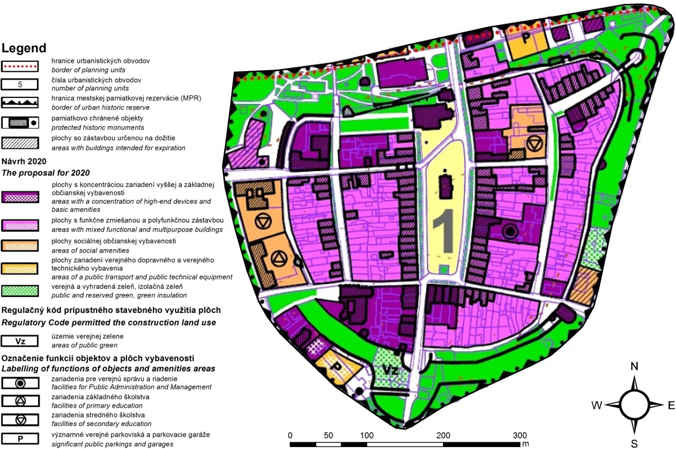
Figure 2. Spatial plan of the historic core of Bardejov (source: map by F. Imrich)
Štramberk
The town council of Štramberk approved the local spatial plan of the town (Územní Plán Štramberka) in 2013 [Fusková et al. 2013]. It consists of the legally binding regulations explanations and of maps. Six maps in the scale 1: 5000 are integral parts of binding regulations i.e. the main map of the plan and five other maps presenting: basic spatial structure of the plan; transport; water management; electricity and communications; publicly important undertakings. Three maps are attached to explanations: the co-ordination map (scale 1:5000); the map of the planned conversion of agricultural land into non-agricultural uses (scale 1:5000) and the map presenting wider spatial context of the town in the scale 1:25000.
The legally binding part refers to the cultural heritage in the very beginning when the protection of urban and architectural as well as natural values and townscape are declared as main aims of the concept of spatial development. Detailed rules of the heritage protection focused on the territory of urban historic reserve and on real estates of cultural value are in the point 2.4 of the concept. Any new construction or reconstruction of existing buildings within the historic reserve has to respect historic plot boundaries. Three conditions are imposed on any construction within the historic reserve. The height of the building cannot exceed the height of existing buildings. Static transport facilities cannot exceed the capacity of 5 places. The construction of row-garages is not allowed. Two rules binding in the whole area of the town refer to cultural heritage. The first says that any construction of new buildings or alteration to existing building in areas spatially linked to areas with historic buildings must be made with respect to the character and structure of historic buildings. In case of the construction in other areas view horizons and visibility has to be taken into account. The second regulation concerns photovoltaic facilities. In places that appear in view perspectives from the urban historic reserve or in distant views to the reserve such facilities will be allowed only exceptionally on the basis of individual assessment provided that the view would be disturbed only minimally. Detailed regulations for each of 7 types of land use (chapter F) within the urban historic reserve contain regulations concerning the heritage protection. The most detailed regulations have been formulated for mixed housing – urban centre (SMC) area that covers the majority of the reserve. The construction in this area is allowed only within historic locations and volume. Historic land division and location of the building on a plot are protected. It means that the construction is allowed only in historic locations. The same regulations have been applied to land not allocated to development (farmland, forest and mixed open space) where the construction of utilities may be exceptionally allowed.
Transport regulations take into account the unique character of the historic reserve. Therefore minimal widths of streets, sidewalks, bike-paths and some other regulations are not applicable to urban centre (SMC area) which covers the majority of the urban historic reserve.
The explanatory part of the plan contains three paragraphs related to cultural heritage of the town. The first is a short description of the most valuable part of the urban area with the unique complex of wooden urban houses on slopes of Kotouč hill. The rule adopted in the legally binding part of the plan is repeated in the same chapter of explanations. It says that within the urban historic reserve and within areas of particular historic protection any construction proposal on plots with historic monuments or on neighbouring plots or other plots where the construction is likely to affect the visibility of the monument should be considered individually with particular attention paid not only to the protection of the very monument but also to preservation of values of the surrounding area. The third paragraph refers to landscape harmonizing. As an outstanding value of the natural and cultural space landscape is protected against destruction. For this reason in the vicinity of cultural or historic landmarks no new “competitive” landmarks should be built. The subsequent description of landscape structure is to a large extent based on historical and cultural criteria. Landscape region is defined as a landscape unit with similar cultural and historic characteristics that differs clearly from other unit in terms of all characteristics or only in terms of some of them. Three types of landscape with important cultural heritage components are distinguished in the area. The built-up landscape is the urban landscape of the town around the 13th century castle. The landscape of forested limestone hills is called “harmonized” due to the balance between natural and man-made components. The limestone quarry is considered a “man-made” landscape.
As regards maps the “co-ordination map” presents the following cultural heritage items: areas of particular historic protection; immobile cultural monuments – single objects or groups of objects of historic importance; buildings of particular architectural values and historic monuments of local importance. The area of historic urban reserve is shown on other maps as well (transport, water management, electricity and communications). The map of basic division of the planning area presents the area where the elaboration of more detailed regulatory plan is necessary due to the vicinity of the historic urban reserve.
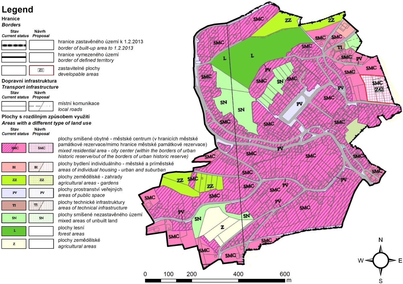
Figure 3. Spatial plan of Štramberk (source: map by F. Imrich)
Dukla
Municipality of Dukla approved its local spatial development plan in 2005 [Szlenk-Dziubek et al. 2005]. The plan consists of the text of binding planning regulations and of the comprehensive map in the scale 1:2000. We analyze the plan that covers the town of Dukla. Other 9 plans cover 25 villages of the municipality. Planning regulations concerning the protection of cultural heritage, historic monuments, contemporary objects of significant cultural value and cultural landscape are gathered in a separate subchapter. It starts from monument protection rules. The list of monuments inscribed in the national register of monuments is placed in the beginning of the subchapter. All these monuments are protected together with their immediate surroundings within designated “conservation zones”. According to the plan monuments from the national register should be kept in the existing use. Alterations to other objects within “conservation zones” are allowed only if they are harmonized with the architecture of existing protected buildings. New electricity lines within the zone should be made in the earth. All earth works in the zone should be supervised by archaeologists. Slightly different regulations apply to monuments from the municipal register. They are not listed in the plan and not surrounded with conservation zones. Alterations to these buildings are allowed provided that basic characteristics of a building are preserved i.e. the size, the form of a roof and historic architectural details. For historic part of the town the zone of cultural landscape protection has been designated. Within this zone historic groups of buildings together with the street network and greenery are protected. Any new construction within the zone must be harmonized with historic buildings in terms of size and architectural style. New electricity lines should be made as cables in the earth. No new “competitive” landmarks are allowed and views to historic buildings are protected. In addition to historic monuments from national or municipal inventories several objects important for the contemporary cultural landscape of the municipality are protected by means of planning regulation. Thirteen such objects have been identified in the whole municipality. Three of them are in the town. These are: the Jewish student house, the “Reconciliation Cross” and the war cemetery from both World Wars. Archaeological sites identified are divided into two categories according to Polish legislation. The archaeological site of a higher historic value is listed in national register. The protection zone is designated around it. Any change of land use is allowed there only under archaeological supervision. Two other archaeological sites without any zones are on a separate list. Any earth works on these sites must be approved by the regional monument authority and the archaeological supervision of works is obligatory.
The map of the plan presents planned land allocations in the first place. Moreover information about protected areas and objects is provided. The following cultural heritage items are among them: monuments from national register with their protective zones; archaeological sites with the zone of archaeological protection; the zone of cultural landscape protection; objects important for the cultural landscape. Moreover the planned historic park is presented as a separate planning allocation.
Contents of Urban Plans and Proposed Principles of the Carpathian Heritage Inventory
All analyzed spatial plans were prepared in specific local conditions of each case-town with respect to national planning and heritage legislations of each country. Each plan contains protective regulations concerning heritage objects. Some objects are listed in national inventories of monuments whereas other are protected locally on the basis of local inventories or directly by planning regulations. The diversity of heritage objects protected in each plan is shown in the following table 1.
Table 1. Protected heritage objects in spatial plans of case-towns
     
The contents of the table can be attributed in the first place to the history of each town i.e. to past events that brought particular objects to existence and to subsequent circumstances that preserved them until now. With this reservation only one can consider to what extent heritage lists from each plan comply or not with the proposed principles of Carpathian Heritage Inventory.
Diversity understood as various forms of heritage is evident in each plan. Townhouses dominate in each town due to the urban character of settlements considered. However objects from all main groups distinguished in the table appear in each plan. Except from fortifications that do not exist in Dukla and except from archaeological sites that certainly exist in Bardejov but they are not shown on the map of the plan and they are not listed in the study on rules of heritage protection.
As far as non-elite selection is concerned the contents of plans comply fully with this principle. Štramberk with the numerous wooden homesteads, castle and townhouses on the market square is the best example. Similarly townhouses in Bardejov built of brick or stone and farm buildings are also protected regardless of their prestige. The plan of Dukla contains protective regulations that refer to palace and historic park, to town hall and to small wayside shrines. Another question that remains outside the competence of local planners is the prestige of objects that rise due to the recognition of the heritage objects. It refers mainly to Bardejov and its position on UNESCO World Heritage List. However surveys carried out in 2012 [Kilián, Vol’anská 2013] revealed strong identification of ordinary residents with historic sites and monuments. In the same survey residents declared that they did not notice neither positive nor negative changes resulting from the inscription of their town into UNESCO list. So the position on the World Heritage List did not affect the contents of the plan in terms of non–elite selection.
Local spatial development plans are by definition biased towards tangible heritage. Their contents refer primarily to physical objects and areas that can be identified and designated precisely in the space. Therefore it is impossible to maintain full balance between tangible and intangible heritage in planning regulations. It is worthy to know that however that in addition to the protection of tangible heritage objects all plans investigated refer indirectly to intangible heritage. The protection of war cemeteries in Dukla refers indirectly to the intangible heritage of battle of Dukla in 1944. Memorial statues and plaques in Bardejov and Štramberk are other examples of this indirect link.
The principle of authenticity and appropriateness seems little relevant to local spatial plans of investigated towns. The principle has been formulated due to the risk posed to the heritage by mass tourism and commercial promotion. All three towns are significant tourist destinations regardless of planning regulations. Spatial plans as acts of local low have their specific purpose as land use and spatial development regulatory instruments. They have very limited influence on touristic attractiveness. The best example is here Bardejov whose attractiveness has arouse much more due to putting its historic core on UNESCO list. Nevertheless the strong identification of residents with historic sites and monuments expressed in the public opinion survey in 2012 [Kilián, Vol’anská 2013] confirmed the authenticity of heritage items protected according to national legislation and according to local planning regulations. The whole principle seems more relevant to intangible heritage like local customs, and traditional events that are more sensitive to the influence of mass tourism.
All plans investigated are made in accordance with the principle of objectivity. In all three towns planning regulations concerning cultural heritage refer to existing objects and urban areas. Spatial planning systems together with heritage protection systems being in place in all three countries assure the high level of objectivity. Planning regulations are formulated on the basis of studies made before the beginning of planning processes. The majority of objects shown in the table above are registered in national monuments lists. Moreover the outstanding values of Bardejov have been recognized internationally (UNESCO list). Relatively few objects have been added to heritage lists by local authorities (Dukla).
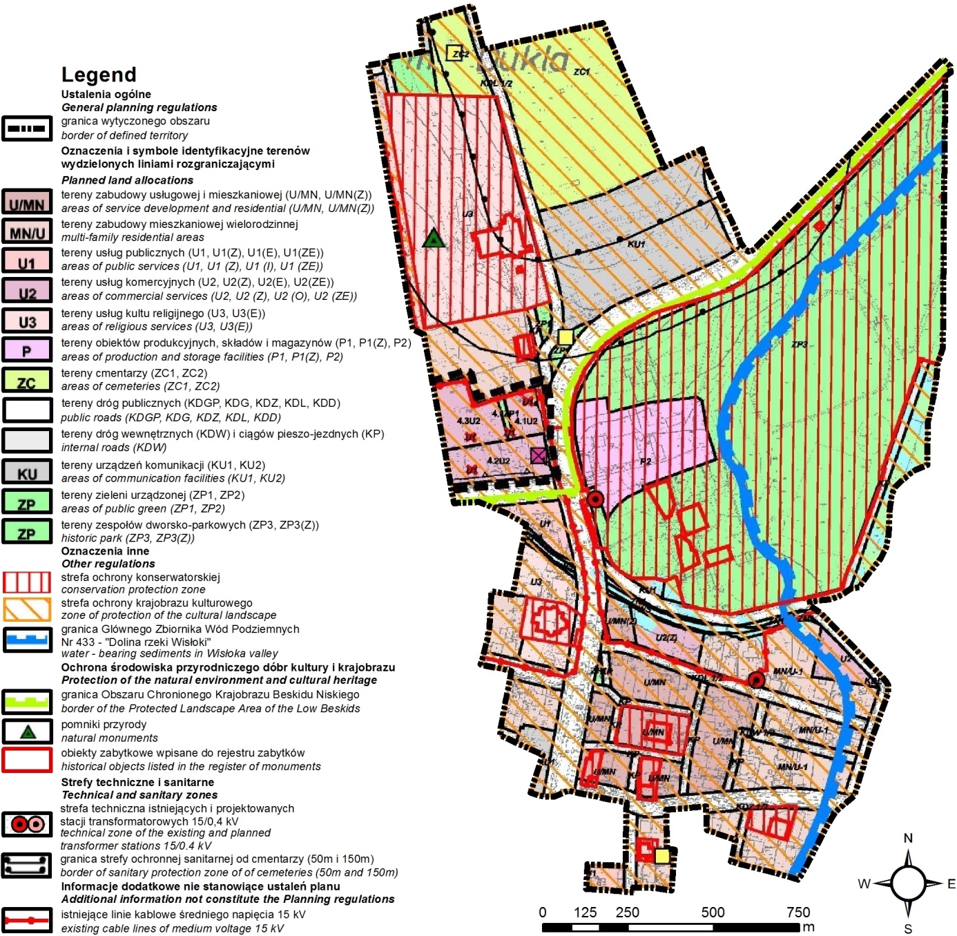
Figure 4. Spatial plan of the centre of Dukla (source: map by F. Imrich)

3. Conclusions

The above paper has been written on the basis of the analysis of three spatial plans of three historic Carpathian towns Bardejov (Slovakia) Dukla (Poland) and Štramberk (Czechia). Therefore the following conclusions concerning the concept of heritage inventory for the whole Carpathians should be considered preliminary rather than final and may be verified and supplemented on the basis of further studies covering wider Carpathian area.
As far as the main research question is concerned one can conclude that there is a high level of convergence between the contents of investigated spatial plans and the proposed Carpathian Heritage Inventory as regards principles of diversity, non-elite selection and the principle of objectivity. As regards the principle of the balance between tangible and intangible heritage only indirect links can be found via tangible objects dedicated to intangible heritage. Opinion surveys have shown [Kilián, Vol’anská 2013] that the inscription of Bardejov into UNESCO World Heritage List did not affect the authenticity of heritage items included in the plan. However it is impossible to formulate general conclusion neither about the convergence nor about the divergence between the contents of all plans investigated and the principle of authenticity and appropriateness due to the lack of direct influence of heritage related planning regulations on touristic attractiveness. This issue requires further research.
The second conclusion is that the very concept of Carpathian Heritage Inventory [ANPED 2011] requires careful consideration if it is going to be implemented. Its relation to existing national, regional and local heritage or monuments inventories should be defined more precisely. Furthermore the range of potential objects to be put in the Carpathian Inventory should be designed avoiding unnecessary overlapping existing inventories. The above presented analysis indicates that the concept of Carpathian Inventory is more relevant to intangible heritage than to tangible one.

References

[1]  Bělohlav, J. (1913). Štramberk. Vlastivědný sborník. 50 č. 15 s. 1-20 [in Czech].
[2]  Conference of Plenipotentiaries for Adoption and Signature of The Framework Convention On The Protection And Sustainable Development Of The Carpathians [CPA] (2003). Framework Convention on the Protection and Sustainable Development of the Carpathians, Kyiv. Available from: http://www.carpathianconvention.org/text-of-the-convention.html [accessed: 25.10.2016].
[3]  Dvořáková, V. (2012). Ochrana pamiatkových území – beh na dlhé trate. Urbanita, 24, č.2, s. 11-15 [in Slovak].
[4]  Fusková, V. Mičková, I. Šiřina, P., Veselá, Z. (2013). Územní Plán Štramberka, Urbanistické Středisko Ostrava, Ostrava. Available from: http://www.stramberk.cz/cs/mesto/uzemni-plan.html [accessed: 17.03.2016] [in Czech].
[5]  Gembešová, L. Horanská E., Kilián, J., Škrovina, M., Urland, A., (2013). Management Plan of the World Heritage Site 2013 – 2020, Historic Center of the Town of Bardejov. AINova, Bardejov. Available from: https://www.bardejov.sk/images/stories/mestsky.../management%20plan_en.pdf [accessed: 06.06.2018].
[6]  Glos, P. et al. (2006-2009). Pamiatková rezervácia Bardejov: Zásady ochrany pamiatkového územia (Aktualizácia). Krajský pamiatkový úrad Prešov, Prešov. 122. [in Slovak].
[7]  Harčar, P. (2012). Mestské opevnenie v Bardejove – vývoj, obnova, prezentácia. In: BARDKONTAKT 2012: “Problematika mestských pamiatkových centier”: Zborník prednášok. Bardejov. 239-242. [in Slovak].
[8]  Janota, E. (1862). Bardyjów. Historyczno-topograficzny opis miasta i okolicy, Druk C.K. Uniwersytetu Jagiellońskiego Kraków 221 s. [in Polish].
[9]  Kilián, J., Vol’anská, L. (2013). Public Opinion Survey and Owners and Users Opinion Survey Conducted in the World Heritage Site – The Town of Bardejov. In: Management Plan of the World Heritage Site 2013 2020, Historic Center of the Town of Bardejov, AINova, Bardejov. Available from: https://www.bardejov.sk/images/stories/mestsky.../management%20plan_en.pdf [accessed: 06.06.2018].
[10]  Kittlerová, K. (2015). Městská památková rezervace a její regenerace –Štramberk –postoje návštěvníků a turistů, bachelor’s thesis Vysoká Škola Polytechnická Jihlava, Jihlava 2015 s 51 [in Czech].
[11]  Ličková, J. (2012). Obnova národných kultúrnych pamiatok v lokalite SKD – UNESCO –Historické jadro mesta Bardejov. In: BARDKONTAKT 2012: “Problematika mestských pamiatkových center”: Zborník prednášok. Bardejov. s 233-238. [in Slovak]
[12]  Ogilvie, M. M. (1897). Die Korallen der Stramberger Schichten. Palaeontographica 7A suppl. 2, s 73-282 [in German].
[13]  Šarišský, M. (2001). Preservation of Cultural Heritage in Urban Areas. ARCCHIP Workshop A03, Prague/Liblice. 4.
[14]  Sjöberg, Ö. (2014). Cases onto themselves? Theory and research on ex-socialist urban environments. Geografie, 119, 4, 299-319.
[15]  Soročinova, A. Soročin, J. (2012). Historické chronogramy versus novodobé reklamy w centrách miest In: BARDKONTAKT 2012: “Problematika mestských pamiatkových centier”: Zborník prednášok. Bardejov. s. 96 – 104. [in Slovak]
[16]  Swieykowski, E. (1903). Monografia Dukli. In: Studya do historyi sztuki i kultury wieku XVIII w Polsce. AU, Kraków, 209 s.
[17]  Szlenk-Dziubek, D. Komenda, J. & Głowacki, W., (2005). Miejscowy Plan Zagospodarowania Przestrzennego Miasta Dukla, Institute of Urban Development, Kraków. Available from: http://dukla.e-mpzp.pl/ [accessed: 20.05.2016] [in Polish].
[18]  Škrovina, M. (2012). Spracovanie plánu manažmentu pre lokalitu svetového dedičstva.
[19]  Bardejov. Plán manažmentu lokality svetového dedičstva ako nástroj ochrany In: BARDKONTAKT 2012: “Problematika mestských pamiatkových center”: Zborník prednášok. Bardejov. s. 56-58 [in Slovak].
[20]  The Northern Alliance for Sustainability [ANPED] (2011). Recommendations on creating of the Carpathian Heritage Inventory. Available from http://www.carpathianconvention.org/documents-thematic-areas.html.
[21]  Ustawa z dnia 23 lipca 2003 r. o ochronie zabytków i opiece nad zabytkami, Dz.U. 162/1568 2003 [in Polish].
[22]  Ustawa z dnia 27 marca 2003 r. o planowaniu i zagospodarowaniu przestrzennym, Dz. U. 80/717 2003 [in Polish].
[23]  Walterová, K. (2011). Městská památková rezervace Štramberk-postoje občanů a veřejné správy k regeneraci a významu pro cestovní ruch, bachelor’s thesis Vysoká Škola Polytechnická Jihlava, Jihlava 2011 s 70 [in Czech].
[24]  Wróblewski, W. et al. (2004). Tędy szli...: operacja Karpacko-Dukielska - retrospekcja 60 lat później, Ruthenus, Krosno 2004, 127 s [in Polish].
[25]  Zákon České národní rady ze dne 30. března 1987, o státní památkové péči, 20/1987 Sb. (1987) [in Czech].
[26]  Zákon z 19 decembra 2001 o ochrane pamiatkového fondu, 49/2002 Coll. (2002) [in Slovak].
[27]  Zákon z 27. apríla 1976 o územnom plánovaní a stavebnom, 50/1976 Zb. (1976) [in Slovak].
[28]  Zákon ze dne 14. března 2006 o územním plánování a stavebním řádu, 183/2006 Sb (2006) [in Czech].
[29]  Žiaran, J. Marek, D. Kovács, D. & Lakata, M. (2007) Územný Plán Mesta Bardejov, Architektonická Kancelária ARKA, spol. s r.o., Košice. [in Slovak] Available from: http://www.bardejov.sk/mestsky-urad/uzemny-plan/schvalene-upd [accessed: 17.12.2015].