-
Paper Information
- Next Paper
- Previous Paper
- Paper Submission
-
Journal Information
- About This Journal
- Editorial Board
- Current Issue
- Archive
- Author Guidelines
- Contact Us
Resources and Environment
p-ISSN: 2163-2618 e-ISSN: 2163-2634
2018; 8(3): 155-163
doi:10.5923/j.re.20180803.07

Community-Based Adaptation to Climate Change: A Case of Soc Trang, Vietnam
 Abstract
 Reference
 Full-Text PDF
 Full-text HTML
Phu Le Vo1, Kim-Nhung Pham-Thi1, Bang Quoc Ho2
1Faculty of Environment and Resources, Ho Chi Minh City University of Technology – VNU HCM, Vietnam
2Institute for Environment and Resources, VNU HCM, Vietnam
Correspondence to: Bang Quoc Ho, Institute for Environment and Resources, VNU HCM, Vietnam.
| Email: |  |
Copyright © 2018 The Author(s). Published by Scientific & Academic Publishing.
This work is licensed under the Creative Commons Attribution International License (CC BY).
http://creativecommons.org/licenses/by/4.0/

Cu Lao Dung, a coastal district in the Soc Trang Province, is surrounded by Hau River and the East Sea. With that characteristic location, the district is deemed to be instantly susceptible to natural processes and calamities, including saline intrusion, alluvial, sedimentation, storm surges, inundation, soil degradation and especially coastal erosion. Those impacts have remarkably affected the society and economy of Cu Lao Dung. According to climate change scenarios for Vietnam released in 2012, more than 95% of Cu Lao Dung area will be inundated due to the rising sea level by 2050. Climate change modeling and assessment with past conditions indicate that climate change might significantly result in loss of agricultural land and increase of saline intrusion, inundated land, and soil degradation, etc. The purpose of this article is to analyze and assess thoroughly the vulnerability of Cu Lao Dung communities, in perspective of climate change impacts along with representing vulnerability commune-detailed levels through setting up a vulnerability map. Vulnerability and Capacity Assessment (VCA) and Rapid Integrated & Ecosystem-Based Assessment of Climate Change Vulnerability & Adaptation (RIVAA) are two principal methods of the study. The proposed solutions to enhance adaptive capacities to climate change based on existing sources of this area are also well discussed. The only remainder of this study is that information gathered lack synchronizing; therefore, vulnerability indexes of interference areas between communes are not appropriately demonstrated.
Keywords: Cu Lao Dung, Soc Trang, Climate Change, Vulnerability, Adaptation
Cite this paper: Phu Le Vo, Kim-Nhung Pham-Thi, Bang Quoc Ho, Community-Based Adaptation to Climate Change: A Case of Soc Trang, Vietnam, Resources and Environment, Vol. 8 No. 3, 2018, pp. 155-163. doi: 10.5923/j.re.20180803.07.
Article Outline
1. Introduction
- Of Vietnam’s regions, the Mekong Delta is generally regarded as the most severe influenced by climate change [1]. This is a quite low-elevation region, situating at the lower basin of Mekong River and confronting a significant number of hazards while the sea level is rising with consequences of the disappearance of lowland, the loss of cultivation land, the decline in biodiversity and the fall in freshwater availability.Cu Lao Dung, a coastal district of the Soc Trang Province, is a territory located in a quite remarkable area, facing East Sea and Hau River to the West. In Soc Trang, this southeast district is well believed as the most vulnerable to climate change impacts like droughts, sea level rise, typhoons, tropical depressions, saline intrusion and other extreme events. Besides, main livelihoods of local community are sugarcane, produce and fruit tree cultivation as well as shrimp farming and fishery. Notwithstanding, such activities are highly depended on geomorphology, climate conditions and extant water resources [2-8]. Meanwhile, coastal areas in Vietnam are prone to be vulnerable under climate change impacts and extreme events [9]; thus, Cu Lao Dung’s community can be affected considerably by these.This article is established to assess thoroughly the vulnerability of typical ecosystems in Cu Lao Dung and main livelihoods of locals under climate change impacts. Simultaneously, adaptive capacity to climate change of local communities are examined to enhance resilience to climate change in accordance with community-based approach.
2. Study Location and Methods
- Cu Lao Dung is geographically located from latitude 9°29’ to 9°45’ and from longitude 106°04’ to 106°17’, with Hau River across and formed by many cays (Figure 1). This is the largest island of Hau River, nearby East Sea, water-surrounded and having a vitally important position in terms of economy, society and national security of the Soc Trang Province. The district has 8 separate administrative units, namely An Thanh Nhat, An Thanh Tay, An Thanh Dong, Dai An 1, An Thanh Nhi, An Thanh 3, An Thanh Nam communes and Cu Lao Dung town.
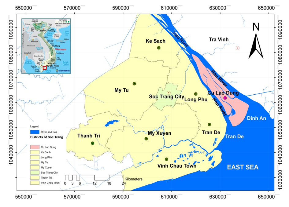 | Figure 1. The position of the Cu Lao Dung District, Soc Trang Province |
|
 | (1) |
 | (2) |
 | (3) |
 | (4) |
3. Levels of Damage by Impacts of Climate Change in Cu Lao Dung
3.1. Characteristic Ecosystems and Contingent Livelihoods
- Interview and survey consequences in Cu Lao Dung District indicates that main livelihoods in local area comprise: (i) Sugarcane cultivation; (ii) Fruit trees production (mango, coconut, longan, jack fruit, langsat, guava); (iii) Vegetable and upland crops (pumpkin, watermelon, indian taro); (iv) Aquaculture (extensive shrimp farming, extensive shrimp farming, extensive elongated goby, intensive elongated goby, Pseudapocryptes elongates breed and several other aquatic products at industrial scale); (v) Service: hired clam harvesting (or being a member of clam cooperative); hired sugarcane collecting; fishery; gathering shrimp, grab, fish and small-sized commerce (Figure 2).
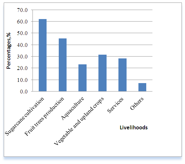 | Figure 2. The main livelihoods of Cu Lao Dung’s communities |
|
3.2. Impacts of Climate Change on characteristic Ecosystems and main Livelihoods
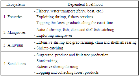
- Climatic factors contribute to changes upon characteristic ecosystems and main livelihoods of locals, including:1) Erratic rains: counter-seasonal rain in dry seasons and heavy precipitation in rainy seasons;2) Long-lasting heat waves;3) Inundation associated with sea level rise;4) Landslide due to the combination of waves, counterwinds and inundation;5) Tropical depressions and typhoons.Climate-related events and risks, which have resulted in both positive and negative effects on characteristic ecosystems, are represented in Table 3 and main livelihoods in Cu Lao Dung District are abstracted in Table 4.
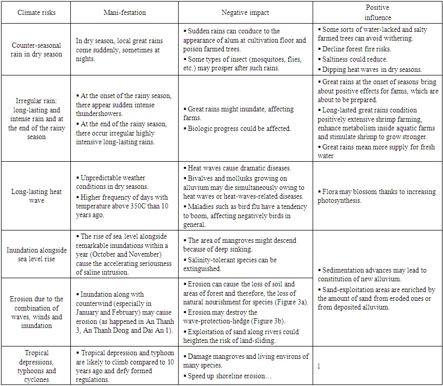 | Table 3. Impacts of Climate Change on Habitat and Ecosystems |
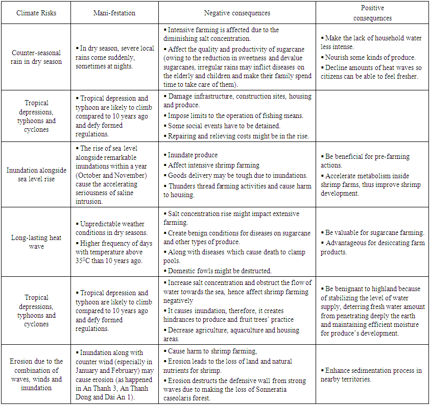 | Table 4. Impacts of Climate Change on Community’ Main Livelihoods |
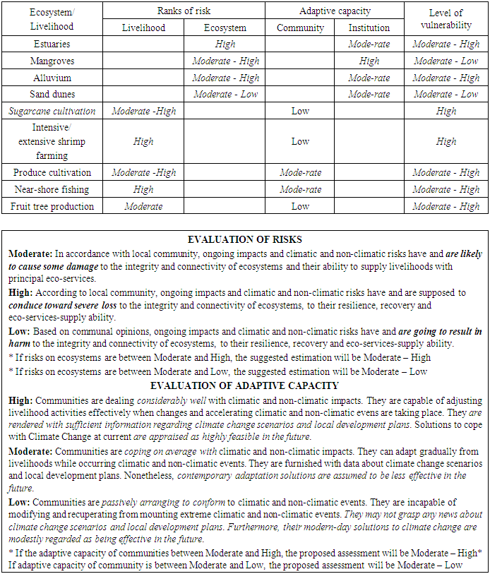
3.3. Levels of Vulnerability of Characteristic Ecosystems and Main Livelihoods
- Vulnerability is estimated through a three-step process: (i) rate risks of ecosystems and livelihoods; (ii) rate adaptive capacity of communities regarding climate change; (iii) rate synthetically vulnerability identified from vulnerability matrixes compiled between risks and adaptive capacity of ecosystems and communities. Synthetic estimation results from vulnerability of communities are abstracted in Table 5.
|
3.4. Vulnerability Map
- The result of calculating vulnerability indexes for each commune based on the abovementioned equations indicate differences between each commune’s figure. The correlation between 3 factors [19]: (i) exposure to natural impacts; (ii) sensitivity of community; (iii) adaptive capacity of community at each commune and correlation in regard to levels of vulnerability of alternative communes is presented in Figure 3. In accordance with this calculation, communes which have higher levels of vulnerability will be more likely to be vulnerable.Results of calculation represent levels of vulnerability in Cu Lao Dung. With the assistance of ARCGIS, vulnerability map is constructed as shown in Figure 4.From the vulnerability map, it can be pointed out that:- Dai An 1 is the most vulnerableCu Lao Dung town is the least vulnerable
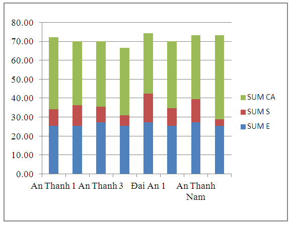 | Figure 3. Factors of vulnerability indexes |
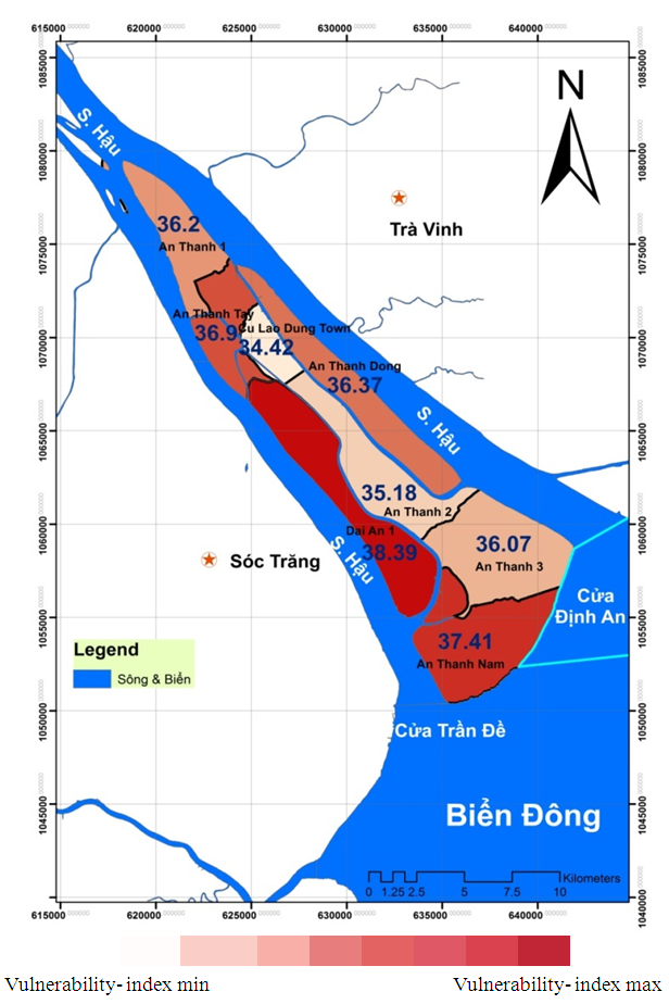 | Figure 4. Vulnerability map for Cu Lao Dung |
4. Community-Based Adaptive Solutions
- From the assessment of the climate change impacts and risks to ecosystems and livelihoods in Cu Lao Dung due to weather, several groups decent community-based measures are proposed to adapt to climate change [20-25] as follows:Group 1: Community-based adaptation to inundation and seal level rise such as enhancing forestry and improving irrigation worksAnnually, particularly in July, August and September, under impacts of inundation and sea level rise, almost farm land is degraded severely, consequently affecting local livelihoods. The break of the ditch and the overflow of seawater contribute to landslide and therefore, interrupting agricultural activities beyond this range of ditch. Several measures listed hereafter can be applied to work the situation out:(i) Local authorities may try to exert local capacities, especially in areas where impacts are most intense, to fortify the ditch. Community contributes their workforce to reinforcement dyke while local government looks for and supplies capital to civilians with what they need.(ii) Planting forest on soil-sand interface. There may be some pilot projects on 1-ha area alongside the dyke, surrounding farm land. The most appropriate suggested species is nipa-palm.(iii) Local government improves propagandistic campaigns to raise people’s awareness of: role and value of mangroves, better irrigation, seasonal calendar adjustment and applying water-saving flora…Workshops can be organized involving raising environment-protection awareness conducted by local Women Union. (iv) Effectively strengthen forest-management model being carried on by Deutsche Gesellschaft für Internationale Zusammenarbeit organization (GIZ). If people involve themselves in forestry, this activity will benefit them currently as well as their descendants in the foreseeable future.Group 2: Approaching sustainable fishery in order to preserve aquatic lineageNear-shore aquatic resources are becoming scarcer than previous times due to over-exploitive methods. One of the reasons is the blossoming number of fishermen and the employment of exploratory gadgets. Ordinary fishing means are nets, fishing rods, frames, rakes, rear-open nets, electric sticks, fish traps. Fishing by “frames” leads to vast death of fish because the size of the mesh is very small. This tool is used along with taking advantage of the flow and even small-sized fish can never avoid. The increasing usage of the tool is minimizing aquatic resources and not recommended by the government. Accordingly, to preserve natural beneficial aquatic products, suggestions are made as follows:(i) Alter from destructive fishing appliances to more sustainable ones.(ii) Conduct cooperative fishery model by establishing fishing team to enhance the effectiveness of balancing between exploitation and preservation of typical aquatic species.Group 3: Improve adaptive capacity to climate change for vulnerable targets through livelihood support and constituting freshwater, hygienic and environmental programmeThe most vulnerable ones are the poverty-stricken and minority ethnic groups, who are less-educated and earn indecent income, as well as the unemployed, women and young children. Cu Lao Dung’s people live primarily on existing resources, hardly find other alternatives. In this situation, local communities exploit natural resources all the way (involving destructive fishing and deforestation, etc.), thus making these resources exhausted. Furthermore, freshwater resource for daily activities is going to be rare as saline intrusion is booming. Aiming to tackle those issues, several adaptive actions are concerned:(i) The government should support training courses for women to resolve occupation problems.(ii) They should also constitute hygienic freshwater –supplying stations and provide indigent households with water tanks used in dry seasons.(iii) The government needs to take care of building toilets for locals associated with propagandizing to raise awareness of protecting the environment so as to reduce contamination in rivers.(iv) Improving livelihoods of the destitute by experimenting highly productive and well adaptable plant species in the mangrove, for example high-yield sugarcane.(v) Learning lessons of climate change adaptive livelihood models and those yielding highly effective benefits in South East Asia.Group 4: Raising local awareness in terms of impacts and adaptation to climate changeAt shown in the survey results on the education, the amount of local inhabitants, who did not attend primary school, were over 35% and those were a mere 5% for people graduating from high school. Owing to the low level of people’s literacy, environment-related skills and knowledge are still restrained. In daily livelihood activities, they are still lacking perception of protecting natural resources. More specifically, local inhabitants are still employing over-exploitation fishing apparatuses, demonstrating low awareness of conserving the environment and lacking teamwork ability to do so. Thence, following measures are proposed: (i) Disseminating and encouraging to applying widely skills, knowledge in regard to environmental protection, climate change adaptation.(ii) Setting up a core-force in propagandist actions, stimulating the participation of Women Union, Farmer Group, Young Communist Party, etc.
5. Conclusions
- Cu Lao Dung is a sharply sensitive area to impacts of climate change due to geographic features and coastal location. Analysis and assessment illustrate that: (i) primary livelihoods are hugely contingent upon natural and climatic factors (husbandry with mainly sugarcane, fishing and shrimp farming); (ii) estuarial and alluvial ecosystems are damaged at Moderate-High level under economic pressure and probable climatic impacts. Sand-dune and mangrove one are at Moderate-low level of vulnerability; (iii) Two dominant livelihoods, sugarcane cultivation and shrimp farming, possess a High level of vulnerability to climatic risks; (iv) Vulnerability map suggests that for levels of vulnerability caused by climate change in different areas are different. From vulnerability map, each area may have the chance to employ congruous measures under current circumstances, aiming at developing livelihoods along with improving the resilience of endemic ecosystems.Proposed adaptive solutions to climate change in Cu Lao Dung are chiefly community-based, which are generally estimated as ‘soft’ measures (or unconstructive), concentrating on livelihoods relating to the most likely vulnerable ecosystems.
ACKNOWLEDGEMENTS
- The authors would like to sincerely thank you IUCN Vietnam, Soc Trang People’s Committee, Soc Trang Department of Natural Resources and Environment, Soc Trang Irrigation Department and Cu Lao Dung People’s Committee for their helpful and willingness to provide the authors with necessary information and relevant data enabling this research. Any errors or shortcomings remain the responsibility of the authors. The authors also would like to appreciate the reviewers those provided knowledgeable comments and suggestions which have largely contributed to the improvement of our works’ quality.