-
Paper Information
- Previous Paper
- Paper Submission
-
Journal Information
- About This Journal
- Editorial Board
- Current Issue
- Archive
- Author Guidelines
- Contact Us
Resources and Environment
p-ISSN: 2163-2618 e-ISSN: 2163-2634
2017; 7(3): 69-80
doi:10.5923/j.re.20170703.02

Nature and Trend of Urban Growth in Saudi Arabia: The Case of Al-Ahsa Province – Eastern Region
 Abstract
 Reference
 Full-Text PDF
 Full-text HTML
Hillo Abdelatti, Yasin Elhadary, Abbas Altayeb Babiker
Faculty of Geographical and Environmental Science, University of Khartoum, Sudan
Correspondence to: Hillo Abdelatti, Faculty of Geographical and Environmental Science, University of Khartoum, Sudan.
| Email: |  |
Copyright © 2017 Scientific & Academic Publishing. All Rights Reserved.
This work is licensed under the Creative Commons Attribution International License (CC BY).
http://creativecommons.org/licenses/by/4.0/

This paper focuses predominantly on the current urban growth in Saudi Arabia taking Al-Ahsa Province of the eastern region as a case study. The main objective of this study is to highlight the trend and causes behind the unprecedented growth that has taken place during the last few decades. To achieve such objective, the paper based mainly on the desk review of the current literature written on urban growth worldwide in general and on Arab Gulf States in particular. This likewise has been enhanced by the observation of the authors. Like other Arab Gulf States, Saudi Arabia has witnessed extraordinary urban growth due to the shift to an oil based economy system. This shift has improved the socio-economic life of the entire population of the Kingdom. Al-Ahsa Province in the eastern region, where oil was found, has witnessed massive urban development. The paper has come out with that, improving of the economy, easy access to fund and availability of the good infrastructure network are the main drivers behind such growth. Unlike the trend of urban growth worldwide, in Al-Ahsa Province some rural areas are creeping to urban and not the vice versa. Without sound planning, urban growth will continue causing negative implications on the environment and social life. Planners have to formulate rational policy aiming to control such growth and at the same time ensure land use sustainability. The paper contributes to the ongoing debate on urban growth and open rooms for further studies to uncover the especial nature of urban growth in the Arab Gulf States.
Keywords: Urban growth, Urbanization, Saudi Arabia, Al-Ahsa Province
Cite this paper: Hillo Abdelatti, Yasin Elhadary, Abbas Altayeb Babiker, Nature and Trend of Urban Growth in Saudi Arabia: The Case of Al-Ahsa Province – Eastern Region, Resources and Environment, Vol. 7 No. 3, 2017, pp. 69-80. doi: 10.5923/j.re.20170703.02.
Article Outline
1. Introduction
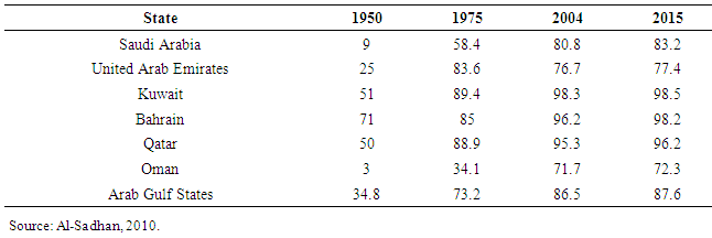
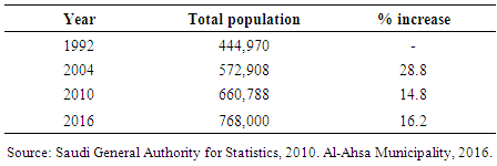
- Currently, urban growth has become an issue of concern among policy makers, planners, as well as researchers. This is due to the fact that more than half of the populations in the world are now living in an urban environment. Moreover, this phenomenon has occurred in both developed and underdeveloped countries with a bit faster in developing countries (Elhadary et al., 2013). Since 1950, the proportion of developing countries' population living in cities has roughly more than doubled from its initial 16 percent (Gilbert & Gugler, 1984). According to (UN, 2001), the urban population in developing countries has increased from 304 million in 1950 to 2 billion in 2001, and expected to double itself in 2030. This growth has impacted negatively on the structural morphology of cities, and effects socio-economic aspects.According to the United Nations Human Settlements Program (UNHSP), 2001, in 1800, only 3% of the world populations were urban. By 1900, this had risen to approximately 10%, and reaching 47% in 2000; and is expected to reach 60% in the year 2030 (Foryth, 2011). Regarding world urban built-up areas, it consumed 400000 km² in 2000 (0.3%).The built-up area of cities in developing countries will increase to more than 600,000 km² in the year 2030 (Angle et-al, 2005). The land taken up by cities amounted to 3% of arable land, estimated at 14 million km² in 2000. Cities are now expected to grow 2.5 times by 2030, consuming some 1million km², or 1.1 of the total land area of countries (Angle et al, 2005).Several factors have been blamed behind the massive urban growth and unorganized expansion in developing countries. These include unequal development and regional disparities, unorganized migration from rural to urban and pre-urban areas, and irrational economic policies. In Sudan, for example, the rural mass exodus to urban centers is attributed mainly to geographically and socially uneven development, the long civil war and armed conflict, natural disasters like drought and famine, and the failure of economic policies (Eltayeb, 2003). In Malaysia, urban growth was owing to the rapid socio-economic development of the country (Elhadary and Samat, 2012). In Arab Gulf States like Qatar, where the urbanization reached 95.3% in 2004 (Al-Sadhan, 2010), the high growth rates are essentially due to massive foreign migration into the region and to extremely high natural increase rate — an abnormal condition in an urban process approaching saturation point (El-Arifi, 1986). In Kuwait, and due to successive migration from inside and outside, the urbanization rates have increased from 51% in 1950 to 98.3% in 2004 (Al-Sadhan, 2010). Whatever, rapid growth in urban areas is imposing high pressures to land and their resources. Also the deep and fast transformations that have been and are being made in different sectors, make evident the difficulties experienced by decision-makers in their management and control structures to detect and effectively quantify urban distortions (Discoli and Martini, 2012).Saudi Arabia was not an exception, during the last few decades, and due to socio-economic development that prevailed throughout the Kingdom, many urban and pre-urban centers have seen a rapid population growth. According to United Nations Development Program (UNDP), 2003, the proportion of the population living in urban areas in Saudi Arabia was 58.4 % in 1975, reached 86.6 % in 2001 and 91% in 2016. This rapid growth has increased the size of built-up areas and made a change in land use, especially in pre-urban areas. Despite this rapid urbanization, still the real causes are not clear and not well addressed. This paper examines the trend and causes behind the rapid urban growth in Al-Ahsa Province. To have a clear idea the paper focuses on the major cities namely Hofuf & Mubarraz (the capital of the province). This is due to the fact that, around 91% of Al-Ahsa populations are living in such cities. Moreover, these centers have witnessed significant changes in its morphological structure due to the early discovery of oil in the eastern region. Since 1970, Hofuf & Mubarraz have seen rapid population growth due to socio-economic development and the significant expansion in the productive sectors. According to Al-Ahsa Municipality (2016), the population grew from 444,970 in 1992 to 768,000 in 2016. It is necessary to mention that, this growth has led to increase in built-up areas and caused many problems such as the problem of solid waste disposal, water supply, sewage, industrial pollution. More importantly, urban growth was the expense of agricultural lands. All of this has led to changes in the morphological structure of the area. The main objective of this paper is to trace the trend and mechanisms of urban growth and its implication on socio-economic aspects. To achieve such objective, the paper based mainly on the desk review of the current literature written on urban growth worldwide in general and on Arab Gulf States in particular. This also has been enhanced by the observation of the authors. The significance of this paper is its contribution to the ongoing debate regarding urban studies and opens the door for more researches. The paper is organized into five sections: the first is an introduction and the geographical setup of the study area, followed by conceptual framework and methodology. The third section is about the urban growth in Saudi Arabia. The fourth Section deals with the urban growth in the study area. Section five is about discussion and conclusion.
2. Al-Ahsa Province: Geographical Setup
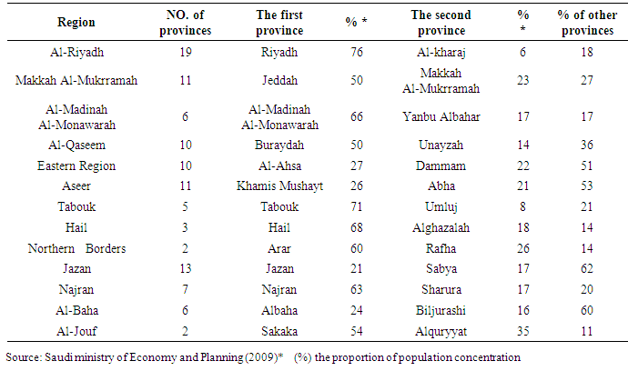
- Administratively, Saudi Arabia has been divided into 13 regions, and each region has several provinces. Al-Ahsa province is a part of the eastern region. It covered an area of about 530,000 km², 24% of the total area of Saudi Arabia, and 68% of the Eastern Region. The big major cities of the province are (Hofuf & Mubarraz) covering an area of about 22,898 km² (Al-Ahsa Municipality, 2016). The other small urban centers include Al-Oyoun, Al-Jafar, Al-Omran, and Juatha. Geologically, the sediments of the province are Quaternary (gravel and sand dunes), Neogene (conglomerates, sand stone, sandy limestone, marls and chale), and Eocene (marine, limestone, cherts, and chale). Hydrologically, there are three aquifers namely: Neogene, Dammam, and Umm- Er Radhma, which are the main source of ground water in the area. Topographically, the province lies in Saharan zone and it is surrounded by sand dunes. Climatically, the area is situated within the sub tropic arid zones, which characterized by very hot, dry summer and cool and relatively dry winter (Al-Jabr, 1984). The main soils are generally variants of sandy loams or clayey sandy loams together with windblown sands. The total population was 1,300,000 in 2012, about 91% settled in urban areas, and 9 % leave rural areas. The majority of the populations (27%) in the region are living in Al-Ahsa province (Saudi Ministry of Economy and Planning, 2009). Historically, the area is the oldest human settlements in the Arabian Peninsula, and contains many historical and archeological sites dating back to different periods of civilizations. Economically, the area is considered as a one of the main important agricultural areas in the Kingdoms. Several economic activities are found such as agriculture, commercial, tourist, and industry. The province location between Dammam (the capital of Eastern Region) and Riyadh (the capital of the kingdom), and between Riyadh and Arab Gulf States adds an extra value to the area in term of growth and development. During the last few decades, the area has witnessed rapid economic development. Recently, it is considered as a one of functional and reliable growth center in the eastern region on which the regional development based on.
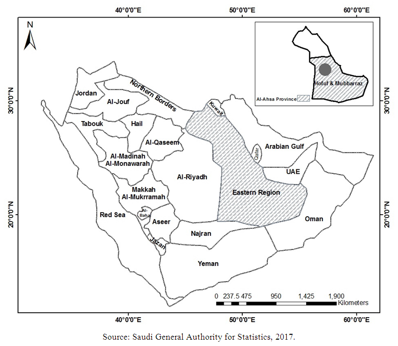 | Figure 1. The location of Al-Ahsa Province |
3. Conceptual Framework
- Several concepts like urban growth, urban expansion, and urbanization have been widely used in the urban literature. Each concept has its own definition in term of urban centers' growth. Urban expansion or urban sprawl is a process of large real estate development resulting in low density, scattered, discontinuous car-dependent construction, usually on the periphery of declining order suburbs and shrinking city centers (Bani, 2014). Urban growth is the rate of growth of an urban population, or the increase in the number of people who live in towns and cities. On the other hand, urbanization refers to "the increasing concentration of people (relative to base population) in urban style settlements at densities that are higher than in the areas surrounding them" (Gregory et al, 2009).Systematic thinking and scientific research about urban phenomenon is not a new matter. Since the mid of the last century, a lot of work has been accomplished. The most important trait of this work is the establishment of a systematic and scientific analysis of urban phenomenon based on theories and models. Due to variations in academic interest and professional disciplines, the systematic work about urban phenomenon has pursued several and different ways of thinking, which in turn reflected in the definition, interpretation and analysis of the urban phenomenon including urban growth. For example, in developed countries, urban growth is viewed as a matter of performance, in contrast in developing countries, is viewed as a result of necessity (Bekle, 2005). In the first half of the 20th century, urban expansion has taken two main tracks: the first in the economic-oriented fields such as urban and regional economics and the relevant sub fields of regional science, geography and urban regional planning. The second draws from the sociology-oriented fields like urban and rural sociology and sub fields of regional science, geography, and urban and regional planning. In the economic oriented field, central concepts and theories appeared. In 1933, Christaller formulate the central place theory to offer a theoretical account of the size and distribution of retail establishment within an urban area. In 1954, August Losch used the conceptual framework of a central place to offer a more general account of patterns of “central place” in a continuous space that accounted for the urban function in addition to retailing (Briassoulis, 2002). Burgess (1967) also explained the process of urban changes and expansion in term of the invasion and succession of one zone (predominant land use) into the next outer zone adjacent to it, with physical expansion of the city the result (Gregory et al, 2009). So for Burgess, urban expansion was seen to be both a stimulus to urban growth and the source of instability, especially in lower-income and immigrant communities. In the sociology-oriented field, the development of school of “human ecology” by sociologists of the Chicago School in the 1920s has had the greatest impact on the analysis of urban change (Briassoulis, 2002), and from the 1910 through to the 1930, the scholars of Chicago School set out to study the city as “a product of human nature” (Gregory et al, 2009). It is important to note that these theoretical efforts have provided answers to many questions, the question of whether urban growth should be resisted, accepted or welcomed (Angle et al, 2005). Generally, population growth, rise in household income, subsidization of infrastructure investment, ineffective land use, excessive growth, social problems in central cities and poor land policies are taken to be the main causes of expansion (Bekle, 2005). Available literature in many parts of the world takes the urban growth phenomenon as a manifestation phenomenon of a change in land use, regardless the complications of this change. During the past fifty years, many parts have experienced rapid urban transformation represented by significant changes in its large-scale expansion of urban and rural areas. This paper believes that urban expansion is a complicated phenomenon and it cannot be viewed from one point of view, so it needs an integrated model that takes into account all points of view, especially those related to the social sciences.
4. Methodology
- This paper is based mainly on a desk review of recent and comprehensive literature written on urban growth. These sources include mainly: reports, periodicals, and current statistical data. Also the paper relies heavily on the report of structural plans made by the Saudi General Authority for Statistics, Saudi Ministry of Economy and Planning, Al-Ahsa Municipality, Saudi Real Estate Fund, the Saudi Ministry of Agriculture, Saudi Geological Survey. Moreover, the paper used several maps of Al-Ahsa area such as the administrative maps, land-use pattern maps, so as to analyze and follow the urban growth changes and directions. This has been enhanced by the observation of the three authors who stayed several years in Al-Ahsa witnessing changes that have taken place during the last two decades.
5. Urban growth in Saudi Arabia
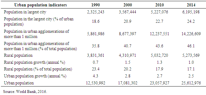
- Since 1970, Saudi Arabia has experienced rapid urban growth. According to Saudi Ministry of Economy and Planning, 2009, the proportion of the population living in urban centers increased from 49% in 1974 to 74% in 1992 and to 80% in 2004. This figure is in line with the World Bank indicates that urban population in Saudi Arabia has reached 25,612,976 in 2014, with annual growth rate 2.5 %, and the proportion of the people living in largest city has reached 24.2, while the total population of cities of more than one million has reached 14,226,609 (table 1).
|
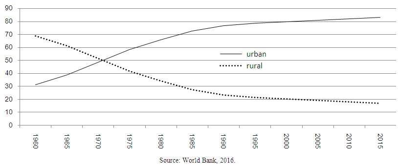 | Figure 2. The proportion of urban and rural population in Saudi Arabia (1960-2015) |
|
|
|
|
|
6. Urban Growth in Al-Ahsa Province
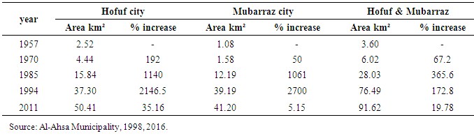
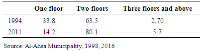
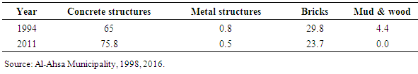
- Al-Ahsa Province is considered as one of the oldest human settlements in the Arabian Peninsula. It was known as Bahrain, then called Hajar, and lately Al-Ahsa. It has gained historical and religious significances since early history, and still played a pivotal role in the region. Based on several studies, settlements in the area can be dated back to more than five thousand years (Al-Omair & Babiker, 2014). The availability of resources, mainly fertile soil and ground water is considered as an essential factor behind the early settlement. However, the form and structure of settlement have been influenced by both physical and human factors represented in the region. These relevant factors include geology, geomorphology, climate, type of soils, water resources, and the division of the inhabitants (urban & rural) (Al-Abdullah Al-Elawy, 1976). Four stages need to be highlighted to trace the trend of urban growth in Al-Ahsa. The first stage was the nuclear stage (before 1963); the second was the growth stage (1963-1973). The third is the developmental stage (1973-1994). And lately the current stage, which began in 1995 up to the present. This division is mainly associated with the essential changes in urban mass during each period. Regarding the first stage, urban growth was concomitant with the availability of water resources, mainly wells and springs which were spread all over the area. The settlement at this stage was in a form of a small number of people surrounding water resources. It is very important to note that they depend heavily on traditional material in building their houses. The second stage associated with the discovery of oil and the flourishing of the economy. This stage was synchronized with the adoption of the Saudi Arabia kingdom of the five – year development plans. These plans played a significant role in improving socio-economic situations not only in the study area, but also throughout the kingdom. Accordingly, the economic situation in the area has improved, land use pattern has changed and the built-up area has increased rapidly. The most important issue which associated with this stage is the change of building material from mud and palm fronds to concrete. The third stage associated with the rapid population growth and increase demand for housing. Therefore, the authorities embarked on the establishment of residential schemes. This has been enhanced by better services and better infrastructure such as roads, water, electricity, and communication networks. Consequently, most of the residents in the old districts have moved to new neighborhoods on the outskirts of the area (Al-Ahsa Municipality, 1998). It is worth mentioning that in this stage, Hofuf city merged with Mubarraz city (figure 2). Regarding the fourth stage, most of infrastructure projects have been completed, the total area has increased to more than 228.69 km², and the built-up area reached 152.20 km². It is necessary to highlight that the urban growth development in the area has not been confined to the horizontal expansion, but exceeded to the vertical one. According to the Saudi General Authority for Statistics, 85.8% of the built-up area consists of two floors and more, with knowing that all or most of built-up area before this stage consisted of one floor (Al-Ahsa Municipality, 2015).Since the early sixties, the area has witnessed a significant increase in the total area which has reached approximately 228.69 km² in 2011s, compared to 184.43 km² in 1992 and less than those in the previous periods. This increase was accompanied by an increase in built-up area which has reached approximately 91.92 in 2011s (table 7).
|
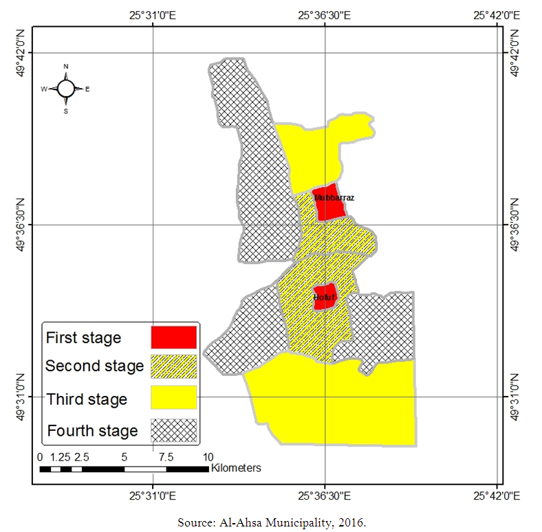 | Figure 2. Urban growth in the study area 1957-2011 |
|
|
|
7. Drivers of Urban Growth in Al-Ahsa Province
- There is a positive correlation between urban growth in Al-Ahsa province and the discovery of oil in 1930. Since the shift to oil based economy in Saudi Arabia, the authority has embarked on construction of basic infrastructure. This had attracted a large number of labors from inside and outside the kingdom. Accordingly, the number of people living in the cities has increased very rapidly and some new residential areas have emerged. Al-Ahsa province is a one of the most attractive areas to labors due to its location near oil extraction areas. Waves of migrants were coming to the province especially after the prosperity of the socio-economic life. Consequently, the number of people inhabiting the area has increased. According to Saudi General Authority for Statistics, the total population of the Hofuf and Mubarraz in 2010 was 660,788, which constitutes 61.9 % of the total province population (Saudi General Authority for Statistics, 2010). This number is estimated to be 768,000 by the end of 2016 (table 11).
|
|
8. Discussion
- From what it has been said, it seems that the nature and trend of urban growth phenomenon in Al-Ahsa Province is very complicated as several direct and indirect factors have contributed to the current growth. These include the shift to an oil based economy, massive in and out migration, natural increase of population, Saudi Government efforts regarding housing, the official efforts in achieving the balanced development between regions, and the improvement of socio-economic life. Our findings show that the growth that has taken place in Al-Ahsa Province is very fast compared to the time and comes at the expense of other essential activities such as agriculture. So, the question that needs to be answered: is the urban growth inevitable phenomenon or planned? In another way: is the urban growth a matter of performance or a result of necessity. Despite rapid population growth and other factor, the economic factor seems to be the main driver of urban growth in the area. Whatever the case, Al-Ahsa area is facing many challenges regarding both, population growth and urban expansion. Rounded road that surrounded the area, the dependence of most of lands outside the urban cluster to Arabian-American Oil Company (ARAMCO) on the west, surrounding of urban cluster by palm farms on the east, the storage activities are the most obstacles that hinder urban expansion. The presence of these challenges further urban expansion will impact negatively. The question that should be asked what is the future of the urban growth in the current condition. Answering this question leads to some significant aspects namely the negative impacts of urban growth which include the problems of waste disposal, water supply, the sewage, industrial pollution and eroding in green spaces. It can be said that, until recently, many neighborhoods were interposed with farms and green spaces, and now urban expansion invade agricultural land on the east, it has been observed that several farms have been converted to residential or commercial purposes. The decline of the revenue coming from agriculture and lack of water are some factors raised behind such conversion. It seems that further studies are needed to investigate that. The paper is not against the urban growth if it is well managed and within the planning process. Our observation has shown that the growth is always comes at the expense of other essential activities mainly agriculture. Several agriculture areas have been converted to settlement and other uses such as a creation places. Statistics indicate that, the agriculture area has decreased to 33% of the total area in 2009 and to 25% in 2011 (Al-Arfaj, 2012). Moreover, urban growth in the area has caused many problems include the problem of solid waste disposal (housing, industrial, agricultural, demolition and construction), estimated at 2000 tons/day, the problem of water supply with a deficit of 120 m³, the increase of energy consumption, air pollution due to cement factory located to the north and small industries distributed in the area. In addition to that, there is also a problem of sewage due to the insufficient treatment stations. Generally, urban growth in Al-Ahsa Province can be described as a condition imposed by the socio-economic development, and will continue unless it will be controlled. The economic growth and the socio-economic development that prevail the area reflects the successful of the five-year development plans, which were adopted by Saudi Government especially in term of regional balance and rural development.
9. Conclusions
- This paper highlighted the urban growth in Al-Ahsa province, which was considered as a one of the oldest human settlements and best oasis of agriculture in the Arab Peninsula. The adoption of oil based economy (1970) and regional balanced development have contributed to the current urban growth. The study showed that, urban growth in Al-Ahsa area was different in terms of rates, mechanisms and trends. Urban growth followed by an increase in built-up area and change in the structure and morphology of the cities. The built-up area has increased from 76.49 km² in 1992 to 91.62 km² in 2011. This usually comes at the expense of other land uses like agriculture. It has been documented that the area under agriculture represents one third 33% in the year 2009 and currently is 25%. Add to this, the current urban growth has become one of the major threats to the local environment. The continuous decrease in the agricultural areas and green spaces in favor of concrete buildings and dark surfaces, beside the air pollution and the blocking of wind is definitely leads to increase in temperatures and seep up the process of climatic changes. These negative consequences in the area characterized by a fragile arid climate will definitely lead to increase the phenomenon of urban heat island. This will impacted negatively on agricultural production and food security in the area, at time of increasing population and increasing demand for food. In consequence, this deep and fast transformation definitely will lead to urban distortion and make difficult for decision-makers to control urban growth unless the authorities formulate clear plan that take into account the balance between concreting and non-concreting surface areas, conserving ecosystems especially agriculture, and strengthening infrastructure. The control of urban growth can be only through the sustainable urban planning that creates sustainable communities – including physical, economic, social, and environmental aspects. As we mentioned before, the study area is a one of the most productive areas in Saudi Arabia, so it needs special attention in term of physical planning. Urban growth is very complicated and multifaceted in terms of causes and consequences, and it needs new approaches that take into account all the relevant aspects that may help in analyzing and addressing it, especially in areas like Hofuf and Mubarraz, where the socio-economic and environmental changes have taken place.