-
Paper Information
- Paper Submission
-
Journal Information
- About This Journal
- Editorial Board
- Current Issue
- Archive
- Author Guidelines
- Contact Us
Resources and Environment
p-ISSN: 2163-2618 e-ISSN: 2163-2634
2017; 7(2): 40-48
doi:10.5923/j.re.20170702.02

Impact of Physical Soil and Water Conservation Structure on Selected Soil Physicochemical Properties in Gondar Zuriya Woreda
 Abstract
 Reference
 Full-Text PDF
 Full-text HTML
Worku Hailu
Department of Water resources and Irrigation Management, Ambo University, Ambo, Ethiopia
Correspondence to: Worku Hailu, Department of Water resources and Irrigation Management, Ambo University, Ambo, Ethiopia.
| Email: |  |
Copyright © 2017 Scientific & Academic Publishing. All Rights Reserved.
This work is licensed under the Creative Commons Attribution International License (CC BY).
http://creativecommons.org/licenses/by/4.0/

Land degradation is a major concern in Ethiopia since it leads to declining agricultural productivity, poverty and food insecurity. Soil degradation is one of the crucial issues in mountainous areas of Ethiopia which needs efforts to reduce it. In the last two decades, various soil and water conservation interventions had been introduced in to different parts of Ethiopia. However, the performance of soil and water conservation structures has not been well studied. Therefore, this study was conducted in Ambachara watershed, Northern Ethiopia to evaluate the effect of soil and water conservation structures in reducing soil erosion and its effect on selected soil properties. Stone faced soil bunds (SFSB) and stone bunds (SB) have been widely implemented in the study area with GIZ support since 1994. Cultivated fields treated by SFSB and SB structures were compared with non-conserved cultivated land (control) and evaluated under three slope gradients {gentle: 3-15%, moderately steep:15-30% and steep slope:>30%}. A total of 27 soil samples were collected from the top 20 cm soil depth replicated three times. Composite soil samples were collected in ‘X’ design square plot with length of 15 m x 15 m. Household survey, focus group discussions and field observations were also conducted to assess farmers’ perceptions on the impact of soil and water conservation structures (SWC) on soil degradation. The results of the experimental study showed that soil organic carbons (SOC), total nitrogen (N), Avail_P, Exchangeable K and Bulk density (Bd) were significantly (p≤0.05) affected by the soil conservation measures. Sand and clay fractions significantly varied with both soil conservation measures and slope gradient. Soil organic carbon and total N were higher while bulk density was lower in soils of the conserved fields compared to fields without conservation structures. No significant difference was observed in SOC and N along the slope but the mean value of SOC and N increased with decrease in the slope percent and decrease in soil bulk density. Similarly, CEC, EC, and exchangeable Ca2+ and Mg2+ did not show any significant differences with respect to SWC measures and slope gradient. Most of the interviewees (83.3%) positive opinion on SFSB and SB on their cropland and its role in improving soil fertility based on their own indicators. From the interviewed farmer, 80% perceived change in crop yield within two years after implementation of the structures. Farmers had a positive attitude towards the SWC structures as they improve the soil productivity. Soil properties were in good conditions in the conserved areas with higher SOC, N and lower BD which are indicators of a fertile soil compared to the non-conserved plots. Further research is recommended to study the magnitude of the effects and for a better understanding ofsustainable land use systems.
Keywords: Soil and water conservation, Stone faced soil bunds, Non-terraced, Stone bund, Water erosion
Cite this paper: Worku Hailu, Impact of Physical Soil and Water Conservation Structure on Selected Soil Physicochemical Properties in Gondar Zuriya Woreda, Resources and Environment, Vol. 7 No. 2, 2017, pp. 40-48. doi: 10.5923/j.re.20170702.02.
Article Outline
1. Background and Justification
- Soil erosion is a major constraint to sustainable agricultural development in Ethiopia especially in sloppy agricultural lands and practically in all cultivated lands, though in varying scale. The magnitude and rate of soil erosion continue to increase despite considerable efforts made during the past three decades in conservation activities .The soil conservation research project estimate an average soil loss of 42t/ha/year on cultivated land and maximum of 300-400t/ha/year in highly erodible and intensively serial cultivated field [1]. Among the factors that have been identified as accounting for severe erosion loss in Ethiopia are; undulating topographic conditions, farming practice which do not consider conservation measure, seasonal intense rains, low soil fertility and lack of awareness on soil erosion problem and the willingness to adopt introduced conservation practices [2].In Ethiopia, natural resources are under great pressure. Land degradation, including deforestation, soil erosion and biological soil degradation had been reported to be very rampant throughout the country. [3] Reported that because of its topographic nature, the removal of land cover leads to soil degradation. Environmental degradation, high population growth in developing countries, and the need to enhance sustainable agricultural productivity are interlocked issues that constitute a triple global challenge currently.Soil conservation structures are an important part of most conservation plans. They provide a stable drainage network to transport excess rainfall, and are increasingly being supported by conservation tillage practices. Nowadays, there is much attention given to improve farm layouts in order to increase production efficiency and stability of soil conservation structures. The function of soil and water conservation is not only to protect the soil but to sustain its productive capacity while using it in a proper condition [1, 4, 5]. Most soil and water conservation efforts focused on highly degraded areas with limited production potential.
1.1. Significance of the Study
- It is possible to say that the farm plots treated with conservation structure face similar run- off but less sediment loss than the ones which are not conserved. Hence, adequate emphasis should be given in selecting appropriate soil conservation techniques for a particular area. However, most developing countries undertake too little research on runoff management. Research done in many countries is often inadequate to provide proven alternative practices for erosion control and soil moisture conservation. Although some basic concepts in this field are potentially of universal application, conservation practices developed in one country need testing and verification, especially in relation to rainfall, soil and local cropping practices, before they are adopted elsewhere [6].The study aims at assessing the variability of soil property between the conserved farm plot and control area where the conservation structures are not applied. This information can then be used to improve land management practices (e.g. tillage operations & fertilization) in the subtropical hilly areas in the study area as well as in similar areas in the country. The study should serve as a guidance and informative document for the people in the area, the GOs, the NGOs, and the agricultural experts who are engaged in SWC.
1.2. Objective of the Study
- The study has two broad objectives. First, itThe objectives of this study are; 1. to assess the effect of SWC measures on selected physical properties (soil texture & bulk density) and chemical (soil organic carbon, phosphorus, potassium and nitrogen and other) properties of soil in conserved and non-conserved farm.2. To assess the attitude/perception of farmers towards the effect of SWC structure in relation to soil nutrient loss and soil degradation problem.
2. Methods and Materials
2.1. The Study Area
- Ambachia Watershed is found in Gondar Zuriya Woreda, North Gondar Zone, Ethiopia (Figure 1). It is 45 km far from Gondar town, 698 km from A. A. Geographically, it is located between 120 23’ 53” to 120 30’ 49” N Latitude and 370 33’ 39” to 370 37’ 14” E Longitude (Figure 1). The total land area of the Ambachia Watershed is about 1622 hectares. The watershed has an altitude range of 1923 to 2851 m a.s.l. The area is characterized by undulating, rugged and hilly topography. About 25% of the total area is steep (more than 30% slope), 39% is moderately steep while the remaining 36% of the area is gentle to sloping relief.
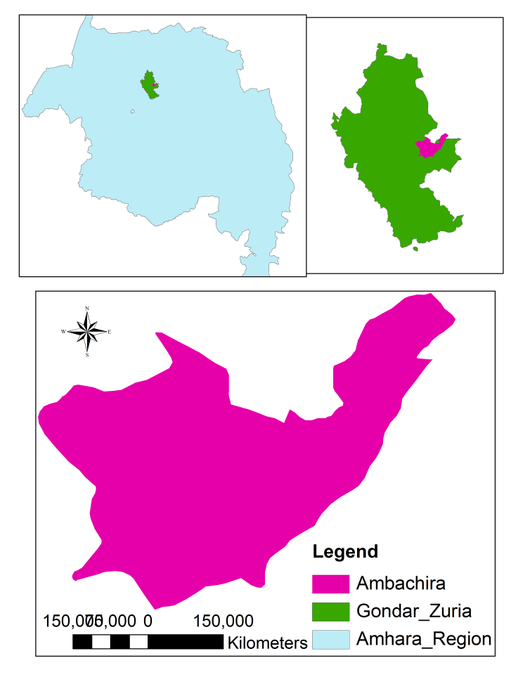 | Figure 1. Location map of the study area |
2.2. Method of Data Sampling
- The research represents a field case study. A reconnaissance survey was carried out to identify representative soil sampling plots. Sampling sites are selected both from the farm plots where different SWC structures are practiced and in plots with no SWC practice in the catchments of the study area. In the case of conserved farm plot, the sampling plots refer to the area between the two successive structures. In the case of the non-conserved plots, the sampling plots refer to the area under cultivation which is found adjacent to each structural type.Soil samples were collected from the top 0-20cm depth at four corners and center of a plot of 10m x 10m size using “X” sampling design as described by [7] with sharp edged and closed, circular auger pushed manually down the soil profile. The availed treatments were selected namely, different SWC structures and farm plot with no SWC measures as control was be used. Therefore a total soil samples were sated as (No treatments * 3slope gradient class *3 rps) were collected in a Complete block Design (CBD) from the top 20 cm depth for soil analysis. The samples were mixed thoroughly in a plastic bucket to form a composite sample. Collected soil samples were air-dried at room temperature, homogenized and passed through a 2mm sieve before laboratory analysis. Moreover, undisturbed samples were taken with a core sampler of height 10cm and diameter 7.2cm for soil bulk density determination.Soil analysis procedureThe composite samples (< 2mm) were analyzed for selected soil properties. Physical property (soil texture and bulk density); Chemical property (Total Nitrogen (TN), Available Phosphorus (AP), Cation Exchange Capacity (CEC), Soil Reaction (pH), Soil Organic Carbon/matter, Available Potassium (AK+) and were analyzed following standard laboratory procedure. The soil for bulk density (BD) determination from all treatment plots using core sampler was taken from undisturbed center of “X” plot for each sample site to a depth of 20cm.Surveys were conducted to assess farmer’s perception on the problem of soil degradation and the effectiveness of the structures in reducing soil degradation. Of the total number of households residing in the study area (PA), only 5% of 603 household heads were randomly selected for questioner survey.Data analysisSoil and water conservation practice (stone faced soil bund and stone bund) and adjacent control farm plots and slope gradient were used as independent variables and the soil parameters as dependent variables. The significance difference of soil property due to SWC practice and slope gradient were tested using analysis of variance (ANOVA) following general Linear Model (GLM) procedure at P≤0.05 level of significance. The data collected in the HH survey were analyzed using Statistical Package of Social Science (SPSS) Software and data was organized, results will be presented in descriptive statistics (frequency tables showing the number of households corresponding to their responses usually expressed in percentages).
3. Result and Discussion
3.1. Soil Analysis
3.1.1. Soil Texture and Bulk Density
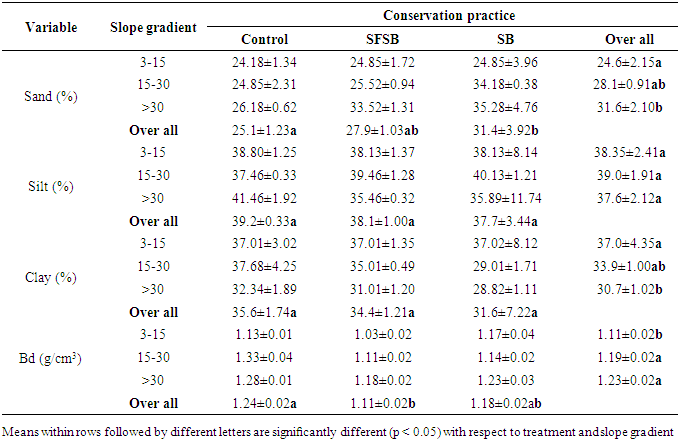
- The result of soil physical properties analyses are presented in Table 1. There was a significant variation in the soil textural fractions of sand and clay with slope gradient. Whereas sand showed significant variation along the treatments and none was observed with clay. The mean sand content was higher (31.6±2.10) and lower (24.6± 2.15) when the slope gradient was greater than 30% and 3-15%, respectively (Table 1). This indicates that it is the inherent soil property and the position on the landscape (slope gradient) which cause the variation in texture rather than the age of structures. With steep landscapes, transportation and translocation of fine particles are expected. This result also confirms the presence of higher clay fraction in the lower slope gradient due to deposition from the upper slope. [8-11] also reported that on the steep cultivated hill slope, the most noticeable changes were a decrease in clay and a corresponding increase in sand and silt fractions as the slope gradient increases. This may be due to the fact that the high mean annual precipitation over the study area may be selectively transported and/or leached fine fractions leaving behind the coarser fraction [12].
|
3.1.2. Soil Organic Carbon and Total Nitrogen
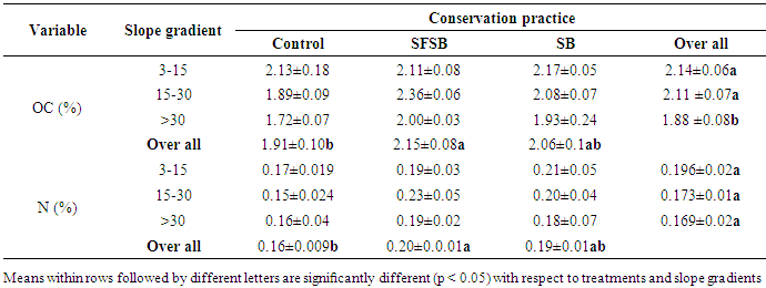
- Soil organic carbon (SOC) showed significant variation with respect to treatment. The soil organic carbon content under the control farm was significantly lower than in the cultivated land under stone bund and stone faced soil bund structures (Table 2). The result agrees with the finding of [12] who reported that soil organic carbon content in soils under three terraced sites were higher compared to non-terraced sites with similar slopes. [16, 13] also reported that non-conserved fields had significantly lower SOC as compared to the conserved fields with different conservation measures.
|
3.1.3. Soil pH, Available Phosphorus (Av-P), EC and CEC
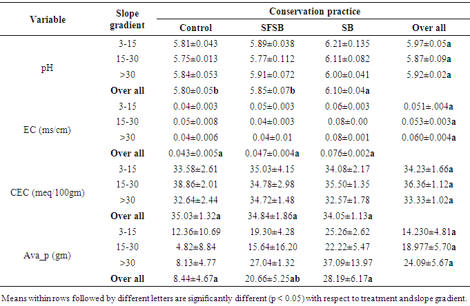
- No significant difference is observed in soil pH with treatments as well as along slope gradient and. The mean values of soil pH were lower in control farm land and As compared to stone bund and stone faced soil bund (Table 3). This variation might be due to leaching of cations in controlled farm plot due to absence of SWC structure that trap soil as well as low ground cover in the farm as compared to the conserved farm plot. Soil pH was lower in slope >30% (5.88±0.02) and higher in 3-15% (5.97±0.05) slope. This could be due to the fact that increasing altitude increases rainfall and thus causing increased leaching and a reduction in soluble base cations leading to higher H+ activity and registered as decreased pH [12]. Similarly findings like [8] lower values of pH were observed in the valley than in the plateau. Generally the soil in the study area can be classified as moderately acidic soil.
|
|
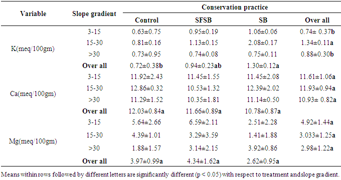
3.1.4. Exchangeable K+, Ca2+, and Mg2+
- Except with the exchangeable K+ other base cat-ions didn’t show significant variation (P> 0.05) with treatments as well as slope gradients. Exchangeable K+ under control farm plot was significantly lower compared to stone bund and stone faced soil bund structure. Under all SWC practices and slope gradient, the overall mean concentration of exchangeable cat-ions is in the order of Ca2+> Mg2+> K+, which was similar with the report of [22].
3.2. Framers Perception on the Impact of SWC
3.2.1. Farmer’s Perception on Soil Erosion and Its Extent Before and after Introducing SWC
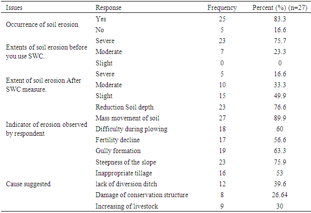
- Generally, perception of soil erosion problem is an important factor to suggest possible solutions for farmers and makes decisions on conservation investments. The perception of farmers in Ambachira watershed showed that soil erosion was perceived as a problem by more than 83% of the farmers All respondents recognized soil erosion as a problem in at least one of their plots, and were also able to identify indicators of the problem to include reduced soil depth (76.6%), 89.9% reported soil loss through mass movement, and 60% mentioned difficulty during plowing as indicators of soil erosion. Reduced productivity of land, declining soil fertility, formation of gully, and soil deposits on river bank were also indicated during focus group discussion. In individual interviews and focus group discussions, farmers commonly indicated that they have witnessed the loss of soil from cultivated fields and the reduction of the depth of the topsoil through time which resulted in increasing the proportion of stones in their farmlands over time. They also revealed that, two decades ago, the soil in the area was generally fertile in nature and more productive but currently; it does not provide yields without the application of fertilizers. The main causes of soil erosion mentioned by farmers included cultivation of steep slope without SWC measures, over cultivation, improper tillage practices (plowing across or diagonal to the slope) and poor drainage of excess water (Table 5). The farmers’ perception on the indicators and causes of soil erosion reflect that farmers had understood the problem and able to evaluate if their actions are mitigating the right causes. Thus, farmers who declared soil erosion as a key problem were asked to list and rank the main causes of soil erosion. More than 75% of the farmers perceived slope/terrain as the main cause of soil erosion. Inappropriate tillage, lack of diversion ditch and damage of conservation structure were perceived to be the other causes of erosion on their farm plots (Table 5). Even though the causes of soil erosion listed above were perceived by most farmers, increase in livestock population and deforestation are also suggested as other causes during the group discussion. This indicates that most of them have got an understanding that soil erosion is caused by combined factors which include both natural and manmade factor.
|
3.2.2. Farmers Perception on the Impact of SWC and Factors Limit Their Use
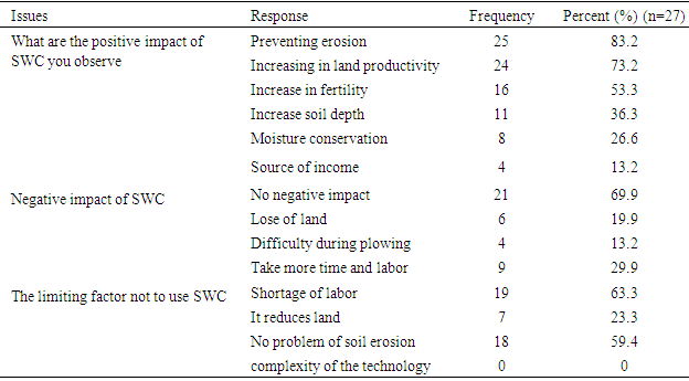
- Farmers were asked the positive and negative impact of SWC implemented on their land as shown in Table 6. Most of the farmers perceived the positive impact of SWC structure on their farm land. Out of the selected farmers more than 83.2% of them address that SWC structures improve their land through preventing erosion, increasing in land productivity and increase in fertility. Additionally, increase soil depth, moisture conservation and source of income were also addressed (Table 6). Only 36.1% of farmers recognize SWC structure development has negative impact through loss of land, difficulty during plowing and the need for additional time. While more than 72.9% have believed SWC structure do not have negative impact. This indicates that farmers has good awareness of SWC structure even the structure is time taking in maintaining soil through protecting soil from different degrading factor. [13, 25, 26] Address that farmers have the positive attitude toward soil and water conservation structures has improved crop yield when compared to non-conserved land.
|
4. Conclusions and Recommendations
- The use of SWC structure is promising in protecting the cultivated land from erosion and the associated nutrient depletion. Farmers seem to have a positive perception of the use of SWC to combat soil erosion and are generally aware of the problem. With regard to analysis of soil characteristics in treated and untreated plots, SOC and total N were higher while BD was lower under the conserved farm. The study showed that increase in slope gradient significantly increase soil BD and sand content while SOC, total N, and clay fractions were decreased. Generally, the soil physical and chemical properties were better in conserved farm plots than the non-conserved plots. Farmers’ opinion indicated that the soil condition in relation to productivity is relatively better on conserved farm plots than on the non-conserved ones. This indicates that good agreement between assessment of soil fertility by farmers in the study area and scientific indicators of soil fertility.The study’s recommendations centers around the importance of enhancing participation in soil conservation measures and the need to explore further conservation strategies and methods. Clearly, a continuous awareness raising efforts through farmers’ participation and a follow up process on the proper management (maintenance) of the structures is necessary. On the other hand, suitable conservation structures to climatic condition and slope gradient need to be implemented. Additionally, there should be an effort to improve soil fertility management practices (combined used of organic and commercial fertilizer) alongside the SWC structure. Finally, further research is required on effects of SWC measures on key soil properties, socio-economic development, environmental impacts, cropping and tillage systems.