Wiyono1, Soemarno2, Sukir Mariyanto3, Arif Rahmansyah4
1Doctoral Program an Environment and Development Brawijaya University, Malang, Indonesia
2Agriculture Faculty of Brawijaya University, Malang, Indonesia
3Physics Department of Brawijaya University, Malang, Indonesia
4Engineering Faculty of Brawijaya University, Malang, Indonesia
Correspondence to: Wiyono, Doctoral Program an Environment and Development Brawijaya University, Malang, Indonesia.
| Email: |  |
Copyright © 2017 Scientific & Academic Publishing. All Rights Reserved.
This work is licensed under the Creative Commons Attribution International License (CC BY).
http://creativecommons.org/licenses/by/4.0/

Abstract
The study was conducted using the method of geoelectric resistivity configuration Schlumberger conveniently Around River Banyuputih Situbondo, East Java with the number of points Sounding as much as 11 Datum points and then having processed using software progress 3 obtained the depth of ground water also by using a reference table Telford page 452 that the resistivity of the water soil or Natural waters (sediments) ranges between 1 - 100 ohm meter. Interpretation (from table) obtained depth of the Naturalwater below the dots sounding, found variations in the depth of 1 m to 46 m. And the pattern variation depth after drawn using software surfer obtained unique pattern of depth soilwater. From the analysis of dats found that the interpretation of depth of groundwater the southern lowland and getting high towards the north of The research area (east beside of The river Banyuputih) and east of the sea and at its peak on the coordinates (500m; 2000m) on the research area or coordinate (114° 14’ 16.2’’ Long. East; 7° 46’ 4.9’’ Lat. South).
Keywords:
Interpretation, Geoelectric, Resistivity, Resistivity, Natural water, Sediments
Cite this paper: Wiyono, Soemarno, Sukir Mariyanto, Arif Rahmansyah, Interpretation of Natural Water (Sediments) Depth Patterns around the River Banyuputih Situbondo East Java with Method Geoelectric Resistivity Sounding, Resources and Environment, Vol. 7 No. 1, 2017, pp. 1-7. doi: 10.5923/j.re.20170701.01.
1. Introduction
The water source is essential for life existence, let alone be in the coastal areas where the water is salty because the salt mostly because it is close to sea level. But not easy to get clean water that can be used to life, the presence of water and the balance is very important to for life.The research was conducted east of the river Banyuputih and the south of the highway Situbondo towards Banyuwangi. The research field on part east The River Banyuputih, The measurement done in the research field with eleven point sounding. Geological stone of research field from North Alluvium consist Cobble, pebble, sand and clay. And then Bagor Formation content Alternations of pumice breccia, tuffaceous sandstone and sandstone, and then Old Ijen Volcanic Rock : Basaltic, lavas, volcanic, breccia and lahar. And then part east Baluran Volcanic Rocks consist Basaltic lavas, volcanic breccia and lahar.
2. Regional Geology Research
The City Situbondo sheet is limited by its coordinates 114° to 114° 30' East longitude, and 7° 30' to 8° 00' latitude south. Regional mapping of the extent of 2250 km2, including in the area City. Situbondo, City. Banyuwangi and City Bondowoso, East Java Regional. Part north sheet is constrained by the Madura Strait, East Bali by the Sea, to the south by Sheets Banyuwangi and in the west by the Sheet Besuki.Situbondo sheet can be achieved by the use of motor vehicles and trains ie from Bandung via Yogyakarta and Surabaya continues to Situbondo. The local transportation facilities in the area of mapping has not been so smooth. Several roads have been partially damaged so it is very difficult to pass a vehicle such as roads leading to the village in the highlands Mountain Ijen.This area dry season lasts from April to October, the rainy season lasts from november to March two seasons punctuated by the transition season.Lowlands, hills and some mountain areas have been used as agricultural land, plantations and settlements. Some regions hilly and mountainous areas still covered by tropical forests, protected forests and shrubs. Coffee plantations, cottonwoods and other developing quite well in this area and sought both by the government, private and people. Teak forest stretching west side Mountain. baluran and some eastern and northern slopes. The results Ijen plantation and sea trout is a commodity that is essential for this area.Wild animals that there are areas of mapping, among others, leopards, panthers, jungle cats, wild boar, deer, bison, peacocks and snakes as well as several kinds of birds, some species of wild animals are protected by the state.Residents in the area of mapping consists of parts of Java, Madura, Bali and newcomers as well as Arab and Chinese descent. The livelihoods of the population as merchants, farmers, fishermen, employees and workers.Residents in the area are predominantly Muslim mapping, and a fraction mostly Christian, Hindu and Buddhist. Educational facilities and teaching have been there and develop well and rapidly, from schools to universities.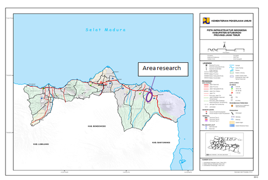 | Figure 1. Location Research |
3. Physiography
Situbondo sheet included in the lane Kendeng and Lane Solo-Volcano Quaternary (Bemmelen, 1949). Solo lane - Quaternary volcanic cone made up of mountains and volcanoes, among others Mountain. Kendeng, Mountain. Ijen, Mountain. Kukusan and Mountain. Baluran. Kendeng lanes occupy areas rather low. Morphology Situbondo Sheets can be divided into 4 units of morphology, namely, volcanic cones, hills, plateaus (plateaus) Ijen and lowlands.Volcanic cones occupies the south and the north eastern tip sheet, characterized by the shape and conical stratovolcano, altitude between 500 m and 2100 m above sea level. Peak, among others Mountain. Kukusan (+ 1994 m) and Mountain. Ringgih (+ 559 m), and Mountain. Baluran (+1247 m). The slope is quite steep slopes. This area is covered by dense tropical forests and some have been used for coffee plantation, which is around the Village and Village Kayumas Kacep. Litology composed of coarse grained pyroclastic rocks until smooth. The river flow pattern radiating "radial centrifugal", valleys narrow, V-shaped, steep cliffs, upstream the smaller, the main rivers among others river. Telaga, river Tultul, river Banyuputih and river Bajulmati.The hills occupy the center of the sheet, are among the volcanic cone morphology and lowland. This area of altitude between 100 m and 500 m above sea level. Litology composed by sedimentary rocks with semi-parallel flow patterns and prune rather wide valleys and form a letter U, rather steep cliffs up ramps. The main rivers among others river. Grujugan, and river. Ampel Tamanceleng. This area is generally used for residential areas and farmland.Plateau Ijen occupy the area around the village of Sempol and Kalisengon allegedly was originally a lake crater of Ijen Mountain Old. Morphology is composed of sedimentary rocks, pyroclastics and igneous rocks, twigs flow pattern. This area is fertile and used for coffee plantation.Occupy lowlands around the northern coast and the east coast, which is characterized by a rather flat terrain with altitude between 0 m and 50 m above the sea level. Litology composed by alluvium, river flow patterned semi-parallel and sloping valleys. This area is generally a residential land, plantation and agriculture.In this sheet, mostly of rock formed by volcanic rocks and the rest by sedimentary rocks. These volcanic rocks are very difficult to distinguish from one another, so as to determine the boundary line litologinya, mostly carried out with much image interpretation, namely by: hue, rock texture, structure and pattern of river flow.In Kendeng Lane, the oldest rocks exposed are Pacalan Member Menuran Formation (Tmpp), which is composed of limestone and marl, Late Miocene-Pliocene. Members allegedly the top to the bottom Leprak Formation (TPL), consisting of between sandstones, calcareous tuffs, calcareous siltstone, calcareous sandstones and conglomerates inserts.Volcanic rocks on the track Solo-Volcano quarter, composed of Quaternary volcanic rocks Old and Young Quaternary volcanic rocks.Quarter Old volcanic rock composed of Formation Ringgit (Qpvr), Ijen volcanic rocks Old (Qpvi) and lava red soil (Qptl).Formation Ringgit allegedly Plio-Pleistocene age, and older sediments rest on the tune. Ijen old volcanic rocks and lava red soil allegedly Pleistocene age.Rock Volcano Quaternary Young aged Holocene and consists of rocks Volcano Ijen Young (Qhvi), Rock Volcanic Roared (Qhvr), rock Merapi Volcano (QVM) and rock Volcanic baluran (Qhvb), Rock Volcano Quaternary Young squash lithologies aged Quaternary Old and Pliocene, Young Mountain. Ijen eruption centers, Mountain.Raung and Mountain. Merapi located in Banyuwangi Sheet.Deposition epiclastic divided into Formation Bogor (Qhsb) that resulted from the destruction of Volcanic rocks Ijen Old and precipitate Belawan (Qbs). Both consist of various materials berbatuapung breccias, and tuffaceous sandstones and tuffaceous mudstone, and allegedly Holocene age-Resen. Surface sediment consists of Alluvium (Qa) and Limestone Reef (Ql) aged Holocene-Resen. Alluvium in the form of stream sediment, sludge and sediment delta coast.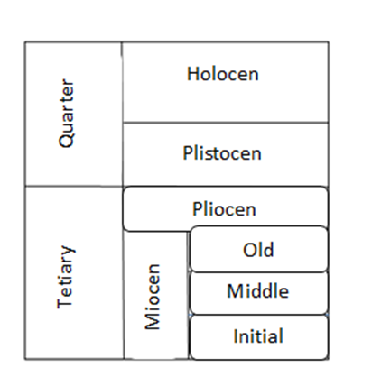 | Figure 2. Stratigrafi of Sheet Situbondo CityEast Java |
Surface Deposition.Qa, alluvium: gravel, gravel, sand and clay, unravel. Alluvium consists of stream sediment, sludge and sediment delta coast. Deposition delta lay around the north coast town of Situbondo. Deposits lay of river along the major rivers. Lay coastal sediment around the coast, for example, on the east coast and partly on the north coast Sheets.Ql, limestone reefs: coral with inserts limestone conglomerate and tuff.Limestone, white to yellow turbid consists of fragments of coral and shells of mollusks, incompressible, hollow, rough surfaces and sharp. Conglomerate various materials, black, white to gray, coarse grained sand to gravel, rounded up rounded responsibilities; Fractional component andesite, basalt, limestone, quartz and shells with a mass of coarse calcareous sand bottom, somewhat compressible.Calcareous tuffs, white cloudy to cloudy yellow, fine to medium grained sand, up to several meters thick. This tuff from the eruption Mountain. baluran.This unit is suspected Holocene age, although in the conglomerate discovered fossil Tikas Operculina Sp., Gypsina Sp., Hetersteginas Sp., Rotalia Sp., Corals and algae. The fossils are believed to be runtungan (reworks) from older rocks. The distribution of reef limestone is present around the east coast, and some still growing coral colonies. This unit of Volcanic rock crushing baluran with alluvium.Rock sediment (Lane Kendeng)MEMBERS tmp, PACALAN DECREASING FORMATION: limestone and marl. White limestone, local Calsium, solid, incompressible, containing fossils of mollusk, corals and foraminifera. Napal, greenish-white, brittle, repui, containing fossil forams, thick several centimeters to tens of centimeters, as inserts in the limestones.The results of the analysis of fossils of several examples of limestone and fossils napalnya: Orbulina Universa D'Orbigny, Globigerina venezuelana Hedberg, Globigerinoides immaturus LEROY, Globorotalia tumida (BRADY), Globorotalia acostaensis BLOW, Globorotalia menardii D'Orbigny. Globigerinoides ruber D'Orbigny, Sphaerodinella dehiscens (PARKER and JONES), Triloculina sp., Pulleniatina primalis BANNER and BLOW, Amphistigina sp., Quinqueloculina sp., Dendritina sp., Globorotalia margaritae Bolli and BERMUDES, Elpidina sp, sp Celantus, Massilina sp, Calcarina sp, sp Orperculina, and ostracods. The above set of fossils show Late Miocene-Pliocene age (Purnamaningsih, 1988), and the depositional environment sub-littoral littoral up inside.Pacalan member is exposed in the northwestern part of Sheets, south of the town of Situbondo, and formed a core of the anticline. This member is horizontally possibility of including "Menuran layer" of his Bemmelen, (1938). The location is the type found in Pacalan, 2 km south of Situbondo, East Java's northern part. Formation consists of marl, clay and tuff; located Type and exposed in the area Sheet in Besuki, East Java (Pendowo, 1992).Tpl FORMATION LEPRAK: interlude between sandstones, calcareous tuffs, calcareous siltstone, calcareous sandstones and conglomerates inserts.Tuf calcareous sandstone, white, fine to medium grained, well-padded with bedding 1.5 m thick, compressible and contains fossils of foraminifera.Calcareous siltstone, colored light gray to brown, layered well, incompressible containing fossils, water works parallel structure. Thick bedding between 10 and 15 cm. Calcareous sandstones, colored light gray to brown, medium to coarse grained, disaggregated ugly, rounded sole, incompressible, thick bedding about 60 cm.Conglomerates, brown, grained gravel to gravel; component consists of fragments of volcanic rocks and sedimentary rocks, rounded responsibility to form a circle, closed containers; basic mass of sand, cement and iron oxide carbonate, compressible. These rocks inserted in the calcareous tuff sandstones and calcareous sandstones.Waterworks and small-scale cross-maze, contained in a layer of calcareous siltstone. In general, the direction field layers show small anticline structure whose core is anticline Members Pacalan.The results of the analysis of fossils of several examples of calcareous tuff sandstone and siltstone identified fossilized Orbulina Universa D'Orbigny, Globorotalia D'Orbigny, Globbigerinoides ruber D'Orbigny, Globorotalia acostaensis BLOW, Globigerinoides trilobus Reuss, Globigerinoides immaturus LEROY, Globorotalia tumida BRADY, Globigerinoides Extremus Bolli. Globigerinoides fistulosus Schubert, Globorotalia tosaensis Takayanagi and SAITO, Globorotalia crassaformis GALLOWAY and JONES, Pulleniatina obliqueloculata PARKER and JONES, Pulleniatina primalis BANNER and BLOW, Orbulina suturalis BRONNIMAN, Brizalina sp, Gyroidina sp, Quinqueloculina sp, Pulleniatina sp, Sphaeroidinella dehicens PARKER and JONES, Uvigerina sp, sp Pyrgo, Glandulina sp, Eponides sp, sp Planulina, Nodosaria sp. Collection of fossils demonstrate the Pliocene age.End, the sub-littoral depositional environment in the sub-littoral to the outside (Purnamaningsih, 1988). Lithologies allegedly menjemari with the upper part of the member Pacalan menuran Formation and allegedly crushed aligned by Formassi Ringgit.These rock units exposed, in the southern city of Situbondo. Location Leprak the type of the region, 5 km east G. Incontinence, or 10 km north Bondowoso, East Java, on Sheet Besuki (Pendowo, 1992).FORMATION Qhsb bagor: put in between breccias of various materials, pumice breccia, tuffaceous sandstones and sandstones. Breccia brownish gray various materials, components composed of volcanic rocks of andesite-basalt, tuff, pumice and obsidian, grained gravel, angled responsibility, mass of coarse sand until smooth, elected ugly, closed containers, local calcareous, solid and layered thick.Pumice breccia brown, weathered, pebble-grained gravel, angled to rounded responsibilities, disaggregated ugly, closed containers, somewhat compressible, layer thickness over 3 m. Brownish gray tuffaceous sandstones, fine to medium grained, composed of fragments of rock, tuff, feldspar, and obsidian, less compressible, containing local inserts 2-5 cm thick calcareous sandstones and repui.Sandstone, dark gray, medium grained, rounded sole, composed of rock fragments and obsidian, repui, a thick layer of 5 m. In this formation encountered cross-maze structure, perarian parallel and tiered layers graded bedding, especially in the sandstone layer.The distribution of lithologies quite extensive, spread about of the western boundary of Sheets to the slopes of northwest G. Baluran. Lithologies allegedly Early Holocene age, and the thickness is not clear.Formation Bagor suppress formation takselaras Ringgit and Old Ijen volcanic rock. Another name is, "Bagor Layers (Bemmelen, 1938). Location type contained in Bagor Mountains, between Bondowoso and Situbondo, in Sheet Besuki, East Java.LAKE DEPOSITS Qbs Belawan: tuffaceous clay.Tuffaceous clay brownish to yellowish gray, slippery, a bit mushy, containing the rest of the plant, partly sandy, well layered, thick bedding between 3 cm and 10 cm.This unit is exposed around the village of Belawan in the crater, thickness about 4 m. Layers tilted towards the south.Volcanic rocks (Lane Solo-Volcano Quaternary)Qtr FORMATION Ringgit: interlude sandstone, tuff and breccia. Sandstone colored yellowish gray, fine-coarse grained, local conglomerate; berkomponen andesite, coarse tuff tuff and pumice with mass smooth, rounded angled sole responsibility, disaggregated ugly, somewhat open containers. The local cross-sedimentary structures found little confusing, tiered layers and perarian parallel, so that most of the rock had allegedly transported the water.Tuff, gray-brown, fine-grained rough, weathered; component quartz, mineral light, glass and volcanic ash.Breccia gray, component leusit andesite and basalt, grained lapilli-bomb, angled-rounded sole, sand volcanoes by sorting massadasar ugly and coarse grained, open container and incompressible.This unit allegedly Early Pleistocene age and deposited in a transitional environment between land and sea. This unit was allegedly pinned and crushed aligned Leprak Formation incongruent by Bagor Formation.Are spreading around Situbondo, surround Leprak Formation. The location is the type found in Mountain Ringgit, halfway between Besuki and Situbondo, in Sheet Besuki, East Java (Pendowo, 1992). PARENTS IJEN Qpvi, volcanic rocks: volcanic breccias, breccia pumice, tuff and lavas. Volcanic breccia, dark gray; component consists of andesite, basalt and obsidian, grained lapilli until the bomb, massadasar tuff; angled hearted, open containers.Tuff, gray to yellowish, coarse grained, containing little obsidian, disaggregated ugly, angled responsibility, repui, rather loose, as a volcanic breccia insertions in grained lapilli, layered thick, somewhat compressible; berkomponen finely crystalline, volcanic glass and debris and a little obsidian.Lavas, dark gray, finely crystalline, vesicular, partly berposong Amigdaloidal, non-uniform crystal; porphyritic, with phenocrysts composed of plagioclase, olivine and pyroxene; massadasar mikrolit embedded in plagioclase, olivine, pyroxene and volcanic glass. The composition of minerals consist of plagioclase (labradorite) 67%, 10% olivine, pyroxene 5%, 15% volcanic glass, mineral ore and 3%. Basal looks inserts or her flow of lava in the form of volcanic breccias.These units are spread out in the middle covered almost half the sheet. This unit is crushed by rocks Young Ijen Volcano, Formation volcanic rocks Bagor and Baluran. While the relationship with Pacalan Member Formation, Formation and Formation Leprak Ringgit, is not clear.This unit comes from Mountain Ijen Old suspected initially had a huge crater and is now a circular plateau to the south constantly to Sheet Banyuwangi, East Java (Suwarti Dkk., 1990).Lavas, gray, scoria, porphyritic texture with phenocrysts composed of plagioclase and pyroxene embedded in volcanic glass mass. Mineral composition is: 45% plagioclase, pyroxene 20% and 35% volcanic glass. Most of volcanic glass have been transformed into clay minerals by devetrifikasi process.This lava appears to have fractured, and moldy red. Possible red soil is what inspired the name Kampung Tanahmerah. These rocks are the same age as the possibility of Ijen volcanic rock Old suspected Late Pleistocene. It seems Lava Tanah Merah is the result of the eruption of the slopes "erupsion flank" of magma Ijen Old.Spreading around Village Tanahmerah, southeast Situbondo. This unit does not contain mineral olivine so indistinguishable from the old Holocene volcanic rocks.ROCK Qhvm Merapi Volcano: put in between volcanic breccia with sandy tuff and tuff, and an insert lava and lava.Volcanic breccia, gray-brown, a component composed of basalt and pumice, lapilli grained until the bomb, mass tuff rough, angled responsibility disaggregated ugly, open container, incompressible and padded with horizontal bedding plane. The local flap lava. Sandy tuff, gray-brown, medium coarse grained, angular to rounded sole responsibility, disaggregated ugly, somewhat weathered and less compressible.Tuf yellowish white, fine-grained, angular responsibilities, disaggregated ugly and less compressible. Berkomponen lava basalt, andesite, volcanic rock fragments, grained mud-lumps. The distribution of these units are in the southeast Sheets and continuous to the south on Sheet Banyuwangi. This unit allegedly Holocene age, and local squash or aligned with volcanic rocks and crushed by the Old Ijen volcanic rocks baluran. This unit comes from Mount Merapi, located in the Sheet Banyuwangi, East Java.Qhvr, volcanic rocks roared; volcanic breccia and tuff.Volcanic breccia, brown, weathered, component andesite, pumice and basalt, grained lapilli until the bomb, angled responsibility, open container, and mass coarse tuff. Tuff yellowish, fine-medium grained, slightly weathered. He's suspected of Holocene. There spreading the southwestern corner sheet and continuous to the west on the sheet and sheet Besuki Jember and Banyuwangi south on Sheet. These rocks come from Mountain roar which lies on the sheet Banyuwangi, East Java.YOUNG IJEN, Qhvi volcanic rocks: volcanic tuff breccias and lavas.Tuff, white-light gray, slightly weathered, fine-grained, layered repui and irregular. Volcanic breccia, yellowish gray colored, sized lapilli until the bomb; component andesite basalt, obsidian and pumice, tuff mass rough, ugly and angled disaggregated responsibility. Lavas, dark gray, Scoriae,cristal not uniform, porphyritic; phenocrysts composed of plagioclase, olivine and mineral ores; mass mikrolit embedded in plagioclase, olivine, ore minerals and volcanic glass. The composition of the mineral composed of plagioclase 52%, 20% olivine, a mineral ore 8% and 20% volcanic glass.The distribution of these units are in the middle sheet, about Ijen Plateau, and continuous to the south on Sheet Banyuwangi, East Java. These rocks are sourced dsri Mountain. Young Ijen located in Banyuwangi Sheet. In the village of Kalisengon, showed him tuff layer structure folds drag (drag fold) which may be due to movement of the fault down in this area.This unit is suspected Holocene age.Qhvb: baluran volcanic rocks: basalt lava, volcanic breccias and lava Baluran. Lavas, gray, hipokristalin, berhablur not uniform; phenocrysts composed of plagioclase, olivine, pyroxene and idingsit, embedded in fine crystal massadasar of plagioclase, olivine, idingsit, ore minerals and volcanic glass. Most shows intergranular texture. The composition of minerals consist of plagioclase (labradorite) 50%, 20% olivine, a mineral ore 10%, klino-pyroxene 10% and 10% volcanic glass. Chlorite and epidote occur as the result of alteration of mafic minerals, and mineral idingsit came from and some of klino olivine-pyroxene. In another example, circled seemed mineral idingsit / surrounded by mineral pyroxene. On the beach Baluran (Bama beach) revealed pillow lava structure, which juts into the sea and strong abraded.Volcanic breccia, gray; component basalt, pumice and obsidian, grained lapilli up bombs, volcanic sand mass disaggregated ugly, angled responsibility, open container and less compressible.Tuff, gray-brown, fine to coarse-grained sand, layered thin (2 cm) were flat, the local clay. Iniumurnya unit is not yet known with certainty, but it is suspected Holocene age.This unit is the possibility of crushing and rock formations Bagor Ijen volcano Old, and allegedly with rock bottom Merapi Volcano. The distribution unit initerdapat around G. baluran, northeastern part of the sheet.
4. Structure and Rock Tectonic
Sheet rock contained in Situbondo consists of sedimentary rocks and volcanic rocks that have not been impaired strong. The geological structure of the region, among others lineaments, faults and anticline. Sheet lining in this field in general is almost flat; except the field of coating on Pacalan Member Descending Formation and Formation Leprak angled slope between 200 and 400.Straightness has a northeast-southwest direction, there are around the foot Mountain. Ijen north. This lineament is the result of remote sensing imagery interpretation, which is partly visible in the form of vertical cliffs, fault scarp, or may be a cliff of a big burly.Fault structure, the results of image interpretation inderaan away. In some places the fault symptoms are characterized by the presence of several hot springs, such as those in Belawan and their drag folds, near Village Kalisengon. Fault contained in this general area cesarean down. Blencong anticline south of the town of Situbondo (Bemmelen, 1938), with the southwest-northeast trending axis, enfold Formation Pacalan, Formation and Formation Leprak Ringgit. This anticline is the result of the folding of the Middle Pleistocene.Geological history sheet is allegedly began in Kala Late Miocene-Pliocene. At that time the region in the form of a shallow ocean basins. In the basin was formed from the Member Pacalan carbonate sediments and sedimentary clastics Formation of Members Leprak. At time Early Pleistocene volcanic activity occurs in environmental conditions that produce intermediate volcanic rocks Ringgit. At time Middle Pleistocene occurred appointment, faulty and folding, which include generating Blencong Anticline. At time Late Pleistocene happen again Ijen volcanic activity and Old Lava red soil, which produces ingredients and spices volcanic lava in a terrestrial environment.
5. Measurement Results and Analysis
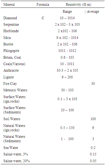
From measurements using geoelectric resistivity method configuration Shlumberger with datum points eleven and then dats we analysed with software progress of three then drawn with surfer software obtained as follows (figure 3).From the analysis of dats found that the interpretation of depth of water the southern lowlands and getting high towards the north and east of the sea and at its peak on the coordinates (500 m; 2000 m) on the research area or coordinate (114° 14’ 16.2’’ Long. East; 7° 46’ 4.9’’ Lat. South), beside river Banyuputih at Situbondo City.The relationship between geology rock by rock resistivity values:Geological research area of the north is alluvium composed of Cobble, pebbles, sand and clay, then Bagor Formation composed: Alternations of pumice breccia, tuffaceous sandstones and sandstone. Then South Formation Old ijen volcanic rocks composed of: Breccia volcanoes, pumice breccias, tuffs and basaltic lava. While the east area of research baluran volcanic rocks composed of: basalt lava, volcanic breccias and lava.Regional research site is above Bagor Formations are composed Alternatios of pumice breccia, tuffaceous sandstones and sandstones.Table 5.2. Resistivities of mineral (Telford p .451- 452)
 |
| |
|
From table 5.2 Telford p.451,452 that Natural waters (sediments) or igneous rocks (ign.rocks) has resistivity values ranging from 1 to 100 Ωm, soil waters with the average price of 100 Ωm, while from table 5.4 Telford p. 454, basalt rock having resistivity values range from 10 to 1.3. 107 Ωm (dry) and Tuff rock has a value of 2,103 Ωm (wet) to 105 Ωm (dry), whereas from Table 5.5, p Telford. 455, the value of resistivity of sandstone sediments (sandstones) range from 1 to 6.4. 108 Ωm, clays (clay) having resistivity values between 1 to 100 Ωm, Alluvium and sand being between 10 to 800 Ωm, and the oil sands has a value of between 4 and 800 Ωm.That there are rocks geologically different but have resistivity values that are in the same range or part of the same. To get a more detailed picture of it in the world comparable data are needed exploration well data or data logging.We can explain with figure 3, following: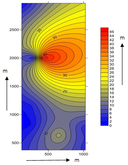 | Figure 3. Pattern interpretation depth soilwater round research area |
6. Conclusions
From the data processing geoelectric resistivity, showed that the interpretation of the depth of the ground water table around Approximately Banyuputih River (East River) and south of the road towards Banyuwangi Situbondo is spreading varied from a depth of 1 m to approximately 46 m. The more towards the south of the more shallow depth of ground water and the higher the bit towards the north east at the highest ground water into more or less at the coordinates (500 m, 2000 m) or coordinate (114° 14’ 16.2’’ Long. East; 7° 46’ 4.9’’ Lat.South) in the study area east of the Banyuputih Situbondo, East Java. Thus we can choose to reside. And the important thing is the cleanliness of the state of the ground water does not contain harmful substances. Thus the soil water content to note, that there should be more research.
References
| [1] | Sidarto, T. Suwarti & D. Sudana, Geology Sheet banyuwangi, East java, P3G Bandung, 1990. |
| [2] | T. Sapei, A. H. Suganda, K.A.S. Astadiredja & Suharsono, Geology Sheet Jember, P3G, Bandung, 1980 D. A. Agustiyanto dan S.Santoso, Geology Sheet Situbondo, P3G Bandung, 1993. |
| [3] | Budisantoso Pendowo, Geology Sheet Besuki, P3G Bandung, 1991. |
| [4] | Benson, A.K., et. al., Mapping Groundwater Contamination using DC Resistivity and VLF Geophysical Methods, Geophysics Vol. 62 No.1, 80-86.1991. |
| [5] | Dobrin, Milton B., An Introduction to Geophysical Prospecting, Mc Graw-Hill Book Company, Newyork.1988. |
| [6] | Hendrajaya, L. dan Arif, 1990, Geoelectric Resistance Specific, Monograf: Methods Eksploration Laboratorium Geophysics, Physics Dept., Bandung Institute of Technology. 1990. |
| [7] | Nazif, A.H., Function Stefannesco as Data Interpretation Measurement Geoelectric, LFN-LIPI, Jakarta. 1973. |
| [8] | Reynold, J.M., An Introduction to Applied and Enviromental Geophysics, John Willey & Sons, Newyork.1997. |
| [9] | Sheriff, R.E., Encyclopedic Dictionary of Exploration Geophysics, 3rd edt. Tulisan: Society of Exploration Geophysics. 1986. |
| [10] | Sumarganal, L., Application Methods VLF for Mapping Contamination of Contaminant at TPA Pasir Impun Bandung. Proceding PIT HAGI ke-28. 2002. |
| [11] | Tachjudin, Geophysical Investigation for Lands Lides with Emphasizeson Refraction Seismic Method, Master Tesis, ITC The Netherlands.1990. |
| [12] | Telford, M.W., L.P. Geldard, R.E. Sheriff, dan D.A. Keys, 1974. Applied Geophysics. Cambridge University Press. London. |
| [13] | Todd, D.K., Ground Water, Mc. Graw Hill Book Company, 1959. |
| [14] | Vingoe, P., Electrical Resistivity Surveying, Geophysical Memorandum. 1972. |
| [15] | Waluya, Theory Basic Geoelestric with Technic Resistance Specific, LFN-LIPI, Bandung, 1984. |

 Abstract
 Reference
 Full-Text PDF
 Full-text HTML