Swidiq Mugerwa1, Kayiwa Stephen1, Egeru Anthony2, 3
1National Livestock Resources Research Institute, Tororo, Uganda
2Makerere University, Kampala, Uganda
3Department of Land Resources Management and Agricultural Technology, University of Nairobi, Kenya
Correspondence to: Swidiq Mugerwa, National Livestock Resources Research Institute, Tororo, Uganda.
| Email: |  |
Copyright © 2012 Scientific & Academic Publishing. All Rights Reserved.
Abstract
Drylands cover 44% of Uganda and hold up to 90% of the country’s livestock herd. The drylands of Uganda interface with climatic variability; in particular drought and flood events often produce debilitating effects. Karamoja sub-region is an important livestock dependent community that accounts for 20% of the national livestock herd. The Karamojong like other pastoral and agro-pastoral communities are dependent on natural ecosystem services for the sustenance of their livestock populations. Several water sources and systems have been developed in Karamoja in order to curb frequent water challenges. This paper provides key findings on the status of water sources for livestock watering in Karamoja, particularly in the districts of Napak, Moroto and Kotido. The study provides the spatial distribution of water sources and the potential movements of pastoralists during periods of water availability and in periods of water stress. It further presents the management challenges and the key lessons learned. The study was executed through a rapid mapping exercise using hand held global positioning systems, interviews and focus group discussions. Dam periphery health assessment was conducted using cross based transect walks. The study established a disproportionate location of the water dams for livestock watering with a high concentration of dams in particular areas such as Rupa sub-county in Moroto District, leading to high grazing intensity and eventually rangeland degradation. Meanwhile, Nakapiripirit district is the most water stressed district in regard to water for livestock with only four dams in the district. Of the four dams, two are located in Namalu sub-county making the larger part of the district unserved. Kobebe and Nakicumet dams in Moroto and Napak districts respectively are the most important watering sources in the event of an extended dry period. These two dams similarly have high potentials of providing multiple benefits to the communities by providing water for irrigation and fisheries. Water quality in dams is generally poor due to high sediment loading and siltation orchestrated by direct watering, high grazing intensity around the dam periphery, cutting of trees and soil erosion. At the same time, management practices are poor and if available are inadequate. All dams are highly exposed to strong prevailing winds thus high evapotranspiration leading to reduced residence time of water in the dam. We therefore find the need for: improved management of water dams, re-align dam development with pasture location sites and grazing sites, build capacity of the community in dam management, sensitize the community on proper watering and strengthen traditional institutions as centers for water management. There is need to develop a monitoring system for water sources in the sub-region so as to facilitate timely response as well as offer perspective into range condition management.Further we recommend for a catchment analysis of Karamoja for the total potential discharge so as to increase the development of small, medium to large multiple purpose dams in the sub-region.
Keywords:
Water, Dams, Livestock, Pasture
Cite this paper: Swidiq Mugerwa, Kayiwa Stephen, Egeru Anthony, Status of Livestock Water Sources in Karamoja Sub-Region, Uganda, Resources and Environment, Vol. 4 No. 1, 2014, pp. 58-66. doi: 10.5923/j.re.20140401.07.
1. Introduction
Karamoja sub-region is the north eastern region of Uganda and lies on Latitude 1˚30’ and 4˚N and Longitude 33˚30’ and 35˚E and covers an estimated area of over 27,200km2[1]. The sub-region is characterized by semi-arid conditions with highly variable climate characterized by sporadic rainfall and high temperatures all year round. The annual rainfall generally ranges between 350-1000 mm[2]. Intermittent variability of rainfall in Karamoja often produces undesirable effects on agricultural production; with crop production being a high risk activity in the region[3] with intermittent dependence on food aid. Livestock herding is similarly affected by the exerting influence of variability on water and forage resources as well as pest and disease prevalence in the region. The dry spells and drought patterns in the sub-region often elicit a food insecurity situation[4] leading to provision of food aid. However, in the recent past, most of the drought events in Karamoja are largely artificial owing to development policies that favor settlement at the expense of pastoralism[3]. The sub-region is part of the greater ‘cattle corridor’ of Uganda that stretches from south western, through the central to north eastern parts of the country. The landscape of Karamoja generally consists of plains punctuated by inselbergs in the central plains and mountains and undulating landscape in the east[3]. The land thus rises from east to west and subsequently several streams and rivers flow from east to west into the plains of Teso. Major rivers include: Dopeth, Kitorosi, Moroto, Acolcol, Okere and several other seasonal streams. Most of these rivers discharge dries up once the rains have ceased to exacerbate the water scarcity problem which is typical and hence an inherent phenomenon of dryland ecosystems. The sub-region can fairly be described as a land of pastoralists and agro-pastoralists. Despite several setbacks that have afflicted Karamoja sub-region in livestock production, livestock still forms the fabric of the social system. Studies have shown that for both income maximization and for resilience (DRR) livestock-based herding has proven the best livelihood undertaking in Karamoja[3]. Despite its importance in sustaining livelihoods of pastoral and agro-pastoral communities, livestock production is however undermined by inadequate water resources. In an attempt to cope with the perennial water shortages associated with dry spells, droughts and erratic rainfall, migration of animal herds in search of water and forage resources is undertaken as the key adaptive coping strategy to the devastating effects of droughts in the region. This however, resulted to inter-clan and ethnic conflicts that further precipitated proliferation of small arms in the region to guard pastoralists’ herds from cattle raids masterminded by ‘superior’ pastoral communities. In a bid to tackle the water scarcity problem, the Government of the republic Uganda and development several partners have undertaken several water development projects for Karamoja, including drilling of boreholes, construction of multi-purposes dams, valley tanks and ponds. Today, numerous water sources exist in the sub-region and offer numerous benefits to the communities in Karamoja and beyond (Kenya and Southern Sudan). These initiatives were undertaken as part and partial of the Comprehensive Disarmament Programme for Karamoja[5].The growing need to further improve water availability, utilization and management in Karamoja so as to improve and increase livestock productivity, build resilience of pastoral communities through improving timely response to water stress negated the mapping of water sources and assessing the functionality and health of these water sources in the sub-region. Consequently, a rapid mapping and assessment exercise was conducted principally in the districts of Napak, Moroto, Nakapiripirit and Kotido.
2. Materials and Methods
The study was conducted in Napak (02 15 00N, 34 15 00E), Moroto (01 31 48N, 34 40 12E), Kotido (03 00 22N, 34 06 45E) and Nakapiripirit (1° 51' 0.00"N, 34° 43' 0.00"E)districts of Karamoja sub-region. The geographical location of livestock water sources particularly dams (larger water reservoirs of up to 10,000m3), water ponds/pans (smaller excavated structures used by herders) and boreholes weremapped using a hand held Global Positioning System (GPS). The GPS points were uploaded in ArcGIS 10.1 using MapSource software[6]. The point data was verified using field data collection templates. During the mapping exercise, associated attributes depicting the current condition of the water facilities were assessed using a 300 meters compass direction based transect-walks. This assessment methodology was adopted and modified as utilized by Riginos and Herrick[7] in monitoring rangeland health.In each of the transect walk, grazing intensity was assessed on a likert scale ranging from very high, high, moderate and low presence. Similarly, soil cover condition was assessed using a likert scale ranging from soft, moderate, hard, very hard and loose soils observed. Meanwhile, exposure, and cover were assessed using percent estimates. Pedestals and gullies were assessed based on presence or absence basis. Plant height for grasses and observed trees were assessed using rapid counts and height estimates. These parameters were selected because they are important in providing information on the health of the range [7] and thus the health of water sources. We also assessed water quality using visual assessment considering mainly color and plant presence in the water as indicative physical parameters[8]. Perception indices using likert scoring (dried (1); almost dry (1); insufficient (2); quite sufficient (3); sufficient (4) and very sufficient, 5) with herders, and elders was used to assess perceived water availability. The herders and elders were asked to assess as to whether the particular water source would provide adequate water for the next three months and whether it has been doing so in the last 3 years (this decision was taken because some of the water sources are fairly new; recently constructed). In addition, we utilized base level retreat and withdrawal marks of the water levels to assess infer the water availability status. We also recorded methods of livestock watering using visual observation and observation of the utilization of livestock watering facilities at the dams.In addition, key informant interviews involving elders, local leaders and seasoned herders were conducted to gain insights on the potential and actual movements of livestock and herders for water during periods of water scarcity. The informants also prioritized livestock water points based on use periods. Together with GPS coordinates, spatial maps were subsequently developed. Focus group discussions were also conducted with the elders (Ikasuko) and youths (Karachunas) with a view of identifying some of the challenges relating to utilization and management of livestock water sources in the study districts. We utilized thematic analysis to summarise focus group discussion data.
3. Results
3.1. Sources of Water for Livestock
Six sources of water exist in Karamoja for livestock depending on season and type of livestock. Boreholes, wind mills (Figure 1) and ponds fall in the first category of water sources utilized mainly to water small stock (goats, sheep and donkeys) mainly by small herders.Goats and sheep watered in these facilities are mainly those that remain within the manayattas. Valley tanks, dams (Figure 2 and 3) and rivers (Figure 4) and river beds provide the second category of water sources for livestock in Karamoja (Plates 1-4). Rivers are mainly utilized during rains while during desperate periods, river bed sand dugout wells are utilized to water livestock in the major rivers. Dams have proven to be useful sources of water for livestock; in Moroto and Napak; Kobebe and Nakicumet dams respectively have proven most important dams. Since their construction, these dams have barely dried. They have thus become convergence points for livestock when the water scarcity problem intensifies in the surrounding districts. Kobebe dam for example hosts the Matheniko and some Tepeth pastotoral communities from Rupa sub-county and slopes of mountain Moroto respectively located in Moroto District, Jie pastotoral community from Kotido District and Turkana pastoralists from Kenya while Nakicumet dam provides for the Bokora and the Pian pastoral communities from Napak and Nakapiripiriti (particularly those from around Lorengdwat and Nabilatuk sub-counties) respectively. | Figure 1. Lotome windmill in Napak District |
 | Figure 2. Nakicumet dam in Napak District |
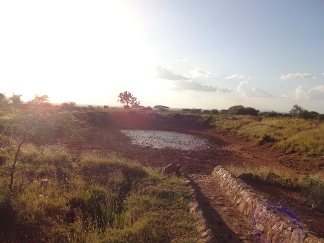 | Figure 3. Lomario dam in Rupa, Moroto district |
 | Figure 4. River Moroto as seen from Moroto district |
3.2. Spatial Distribution of Livestock Water Sources and Water Availability
The distribution of dams in the three districts is non-uniform with the concentration of dams in a few sub-counties. In Moroto District for example, nine out of ten dams in the entire district are located in Rupa sub-county (Table 1; Figure 5). By the time the study was conducted (October-November, 2013), seven dams including Lokisilei, Kadilanke-Kanakol, Kanakol, Lomario, Kisop, Kidepo, Nawanatao, Pupu and Rupa had dried with only two dams (Kobebe and Kaloe) still holding some water. Observations revealed that the water in Kaloe dam could barely last up to mid-December-2013 implying that the livestock which were watering in this dam had to either move towards Kobebe or towards Arecke dam in Napak District. Further, minimal water sources for livestock exist in Katikekile sub-county yet the sub-county is classifiedas one of the pastoral livelihood zones in the sub-region. In Nakapiripirit, three of the four dams were located in Namalu with one dam found in Lonrengdwat and no dam was observed in other sub-counties such as Lolachat and Nabilatuk. Meanwhile, the dam at Lorengdwat was already dry by the time of the study. Additional information obtained from the herders indicated that the dam usually dries around late October to early November. Meanwhile in Napak District, Areceke-Nakicumet dam still had considerable volumes of water that could last through the dry season up to March/April of the following year. It is important to note that the water in Nakicumet dam is currently serving multiple benefits including irrigation purposes (Figures 6 and 7) and fish farming (one fish pond has been set-up at Nakicumet). The other two dams (Lomamururak and Nabokat) had water but was considerably lower in volume thus at the verge of drying.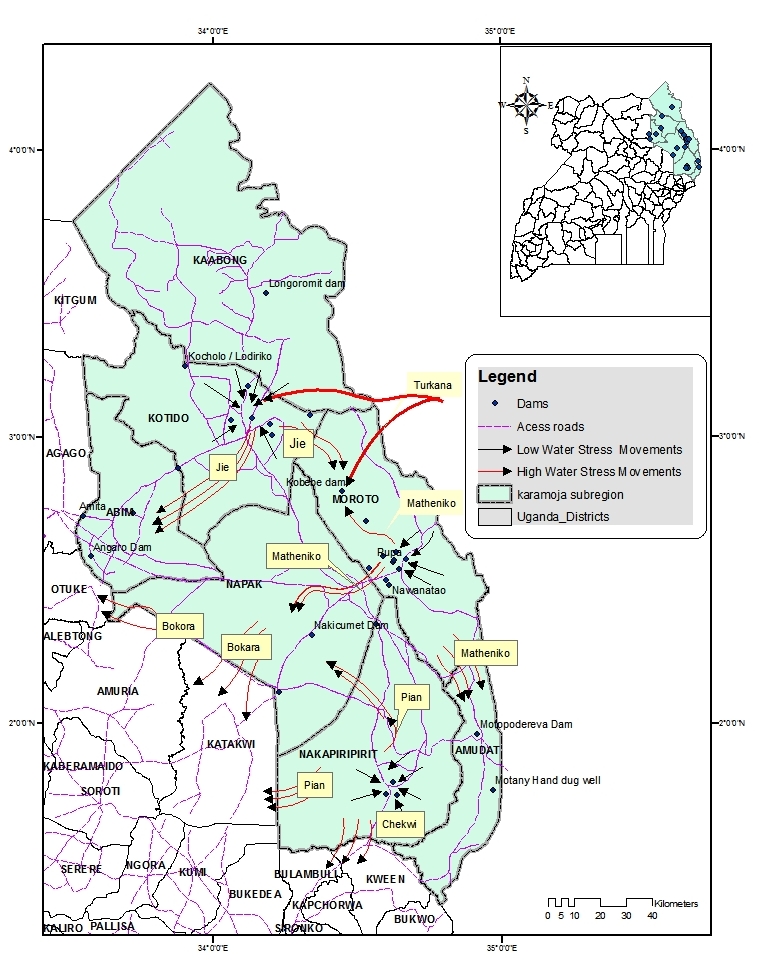 | Figure 5. Spatial distribution of dams and tribal movements of herders during periods of varying water stress |
 | Figure 6. Prepared gardens laid with drip irrigation pipes at Nakicumet |
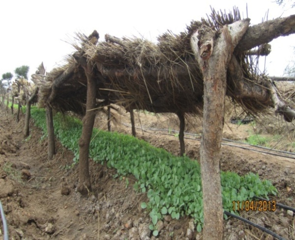 | Figure 7. A seed bed of vegetables awaiting transplanting |
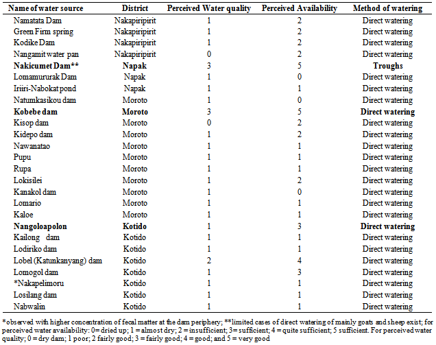
Table 1. List of dams in Napak, Nakapiripirit, Kotido and Moroto Districts
 |
| |
|
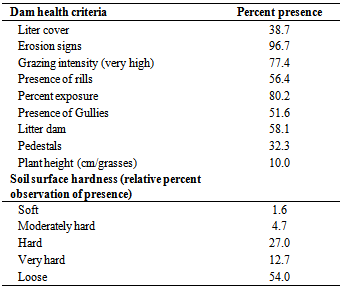
3.3. Water Source Management, Health and Water Quality
Of all the water dams identified in the three districts, only Arecke-Nakicumet dam had a functional water use committees. The dam had two water use committees: the Water Users committee and the Irrigation Water users committee. The Irrigation Water users committee on the other hand consisted of two sub-committees (Dam monitoring committee, Decision and Development management committee). These committees seem to have functioned; given the health of the dam periphery in comparison to all other dams. The water quality in most of the dams was poor; this was precipitated by direct watering of livestock in the dam (Figure 8), heavy runoff, and destroyed and lack of erosion checks. As such, the water was mucky full of silt and sediment load, and some dams were blooming with water weeds (Figure 9). At Nakicumet dam where the water was fairly good, some sections of the dam were covered by water weed. In general, the water dam periphery was poor depicted by the dam health indicators portrayed in Table 2.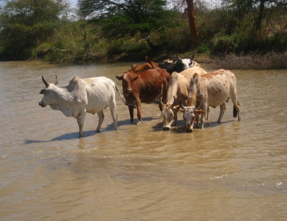 | Figure 8. Direct watering of livestock in Lomogol dam in Kotido District |
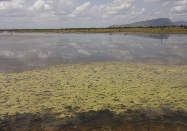 | Figure 9. A greeny water weed blooming in Nakicumet dam |
Table 2. Dam health indicators
 |
| |
|
Regarding dam health, we observed that all dam peripheries depicted a very high percent exposure (80.2%), a very high grazing intensity (77.7%), and existence of erosion signs (96.7%) through the presence of rills (56.4%), presence of gullies (51.6%) and presence of litter dams (58.1%). The soil surfaces were generally loose (54.0%) and hard (27.0%). Because of the high grazing intensity (77.4% in the very high category), average plant height for grasses in the first 100 meters from the dam was estimated at 10 cm. However, we observed slightly higher grass height in Nakicumet-Arechek dam. This is attributable to the dam management strategy that restricts grazing around the dam and direct watering in the dam.The assessment further reveals that with exception of Kobebe and Nakicumet-Arecheke dam, wateravailability in all other dams mapped was insufficient to cover the forth coming dry period (November through February) before the rainfall onset in March. A considerable number of dams mapped were found almost drying up with water having receded towards the dam bed (Table 3). Most of the dams (Table 3) had poor water quality with high silt content observed. This state was attributed to direct watering of livestock in the dam in total disregard of livestock water facilities provided at the dame periphery. Most of these livestock watering facilities such as troughs, boreholes (for pumping) and photovoltaic energy installations (solar systems) were either vandalized and/or functionally unusable.Table 3. Water quality in the dams of Napak, Moroto, Kotido and Nakapiripirit
 |
| |
|
3.4. Water Use and Management Challenges
Observations, interviews and discussions during the mapping exercise revealed that dams provide multiple use benefits to the communities. Besides watering livestock, dam water is used for domestic purposes including: drinking, brewing, cooking and bathing. Irrigation, fish farming and development is also slowly being undertaken using dam water in Nakicumet. Management of the dams faces a number of challenges including: ● Lack of community involvement at the time of dam construction; decisions on the construction of the dams are taken by technocrats with minimal consultation with the local communities except for the dams (ponds) constructed near the homesteads. These are often supported by the non-governmental organizations. The communities thus perceive themselves as recipients and the others as providers.● Vandalism, the pipes and metals are removed by the herders and youths for making bangles and spears for hunting and other uses. At Kaloe dam for example, the watering troughs had been vandalized and the water pipes leading to the trough from the pumping borehole disconnected and strewn on the ground. It was also observed that windmills that had been constructed to provide water for livestock were dysfunctional while some had parts vandalized for example; at Rupa, Lokali in Moroto district; Nakobekobe and Koboyen in Nakapiripirit district and the Angaro and Kopua-Lorengchora windmills in Napak district. Similarly, a dam that was commissioned in June, 2013 at Lobel in Kotido district fitted with solar pumping system got vandalized in three months that by the time of study, the pumping system was dysfunctional. ● Lack of initiative to manage the existing facilities. Whereas, the community is keen at finding out who is visiting and/or is at the dam, the same community barely has thought of taking initiative at properly managing the dam for posterity. All the dams that had previously been fenced after construction had their fences vandalized and exposed. In one of the discussions, a participant remarked that “that is GIZ dam, and the other is a government dam” thus it is the responsibility of GIZ and government to maintain. ● Direct livestock watering, in all the dams visited, livestock were watered directly in the dam. This destroyed the dam embankments, exposed the dam to siltation and soil erosion. Despite observing a few goats and sheep being watered in Nakicumet-Arechek dam, it was generally not a common practice. The herders here seemed to observe the set standards in using the watering troughs located across the road, about 2 km from the dam on the northwestern trending. ● Convergence of various pastoral groups; Kobebe dam (Moroto district), Nakicumet dam (Napak district) and Namatata dam (Nakapiripirit district) are convergence dams. At Kobebe dam, some Jie from Kotido district, Turkana from Kenya, Tepeth and Matheniko from Moroto converge with their livestock from around October to March. The pressure on the dam is quite high and coupled with direct watering; the dam periphery has been rapidly deteriorating since it was constructed.● Limited capacity and lack of equipment for managing expansive dams in particular Nakicumet and Kobebe dam. Nakicumet and Kobebe dam are very large dams and fairly deep. These require specialized equipment for removing water weeds that cover the water in the manner of an algae bloom.● Dams as poaching grounds, in some of the dams it was observed that poaching taking place. Snares could be observed in some of the dams, at Nakicumet dam, over ten snares for ostriches were laid on the eastern banks of the dam. ● Where most dams are located, luxuriant Acacia and Balanites subsist. At present, these trees have are threatened by increased tree felling for charcoal, firewood and homestead hedging. This further exposes the dams to prevailing winds that increase evaporation from the dams.
4. Discussion
The spatial maps developed have shown a concentration of water sources in the sub-region in areas closer to homesteads (manyattas). This mode of water development depicts a considered emergency effort to address water scarcity challenges, meet national domestic water service deliveryobjectives, increase production potential and eliminate constrains to water access. However, such emphasis on the development hardware facilities (construction) at the expense of the software considerations in particular environmental and social concerns and sustainable management has detrimental effects in pastoral communities[9]. Where such developments have been undertaken, pastoral mobility is constrained; this in turn affects pastoral productivity and economic performance[9].Evidence available from pastoral areas of Ethiopia documented over the last forty years, shows that; water development inconsiderate of in-depth understanding of pastoral livelihoods compromises sustainable development in the long run, despite addressing water shortages in the short term[10]. It is however important to note that to pastoralists, water management constitutes part and partial of rangelands management because access to and availability of water affect who and how many have access to surrounding pastures and grazing areas[10]. Further, environmental degradation associated with wrongful placement of permanent water sources has been observed[9]. This is because water sources can alter usage patterns for other resources, in particular pasture to the detriment of rangeland quality and livelihoods[10]. It is already documented among the Borana of Ethiopia that where traditional wells exist, the shortage of pasture is a more critical reason for the regular mobility[11]. At present, the degradation observed (such as presence of erosion, gullies, high ground exposure, and low plant height) in and around the water sources appears to be orchestrated by increased localized watering, reduced mobility and increased grazing intensity within the closer rangelands. In the longer term, the presence of these permanent water sources is likely to alter the pasture dynamics within these locations. Moreover, their concentration in particular locations further exacerbates livestock concentration effects.The management of water sources suffers from limited interest in non-incentivized participation. During the assessment, only one dam (Nakicumet-Arecheke dam) had a functional dam management committee. As earlier noted, this dam considerably had better health and water availability. In most of the dams, communities either waited for the developers to de-silt and/or pay for de-silting. Meanwhile in a contradictory spirit, the urge of ownership (our dam) was highly evident. It was therefore evident that at the time of development minimum consultations, sensitization and role allocation was undertaken. Community participation at water source development was minimal. Thus, the community has tended to consider water source development as leverage for monetary gain and/or food relief (as often food for work is provided for hand dug ponds within and near the communities). However, according to Gitonga (2011)[12] community participation is identified as a prime mover of sustainability. In Kenya for example, where communities’ capacities to manage, operate and maintain the water sources has been developed through improving community structures by forming and/or strengthening Water Users Associations (WUAs) water availability is extended and so has been the water source health[13].Where minimal community engagement is undertaken and where sociological aspects of water are ignored in water development, this often has led to conflicts, destruction of equipment and degradation of the surrounding lands[14]. These scenarios have not been in short supply in Karamoja sub-region. Conflicts over access and watering rights tend to increase during the dry spells while localized degradation and vandalism has been documented in this study. In a study conducted in Isiolo Kenya, it was observed that the operational reliability of water sources was associated with the availability of good community management structures [15]. Thus, there is incentive involving the community in the management of the water sources. This however largely depends on the level with which the community has understood its role.
5. Conclusions and Recommendations
The assessment exercise has unraveled the disparity in water source development in Karamoja sub-region with increased development of water sources around settlements (manayattas). This has in part led to reduced mobility and increased grazing intensity evidenced around the water sources thus leading to localized degradation. Larger areas of the sub-region to the south and west (Napak) have fewer water sources compared to parts of Moroto and Kotido districts. The current pattern of development thus needs to be reconsidered while taking into account three fundament issues inherent in the pastoral communities; that; (i) water developers ought to understand the rangeland context for effective planning; (ii) strive to rehabilitate and develop water sources with sensitivity to rangeland dynamics and pastoralists needs; and, (iii) developers should seek to secure sustainability through capacity-building, user contributions and strengthen and use customary institutions and practices. Accordingly, the following ought to be undertaken:● Water source development and their maintenance ought to be carefully planned to scale down the over concentration of water sources in particular locations. In particular, considerate development should take action to carefully locate water sources in dry season grazing pastures and strengthen customary institutions for managing these water sources. ● Location of water sources during development should be based on a scientific catchment analysis so as to reduce the existence of dry water sources resulting from limited runoff from the catchment. Further, scientific analysis will address the soil and geological constraints. This will help address issues relating to water sources established in too sandy locations.● Stakeholder consultation, sensitization, capacity building and partnership need to be encouraged. Government, NGOs and development partners need to move from crisis response to building for posterity. The resilience of the communities livelihoods should now take a center stage and community based engagement ought to be championed in water development and management. ● Existing management committees need specialized training in managing water sources. The current expansive water sources such as Kobebe, Nakicumet and other considerably larger size dams have not been in existence as such the communities are in a learning process and continued support will be vital. They equally need to be supported with specialized equipment such as boats to enable them navigate the interior of the dams during maintenance works. Further, in a bid to strengthen community collaboration in water sources management, support could be channeled to the establishment of Water Users Associations (WUAs). ● Water sources with considerable volumes of water ought to be utilized for multiple benefits. This will provide incentive for maintaining dam health and range condition health. The Nakicumet dam at the moment can be used as a learning center for proper management and multiple benefits. This intervention however ought to be carefully introduced with scientific evidence to match the water volumes available and other activities to be introduced. For example crop-water requirement needs. ● In addition, the current water sources can further be developed to enhance community based tourism in the sub-region. Consequently, there is need to sensitize the communities against poaching wildlife on water sources. Alternative income sources emanating from such wildlife could be an additional incentive for conservation and better management of water sources. The Uganda Wild Authority (UWA)need to take keen interest in this direction. ● There ought to be coordinated efforts in water development in Karamoja sub-region. The Karamoja NGO forum should be utilized as a platform for sharing agency programme activities to enhance synergies and reduce on waste of resources associated with duplication in the same communities. We however note that this should not become a terminal that introduces unnecessary bureaucratic chains that curtail timely response.
ACKNOWLEDGEMENTS
The study was funded by the European Union, Food and Agriculture Organization of the United Nations, Kampala-Uganda and Office of the Prime Minister-Uganda through implementation of the Animal nutrition sub-component, under “Result Area four” of the Karamoja Livelihood Improvement Programme (KALIP). We also appreciate the additional support provided by the Department of Animal Production and Marketing from the Ministry of Agriculture, Animal Industry and Fisheries of Uganda
References
| [1] | National Environment Management Authority(NEMA), 2010, National State of the Environment Report for Uganda 2009/2010. NEMA, Kampala Uganda.[Online]. Available: http://nema-ug.org/national_s_o_reports.php |
| [2] | Nalule, A.S., 2010. Social management of rangelands and settlement in Karamoja. Report submitted to Food and Agriculture Organisation of the United Nations, Kampala Uganda. |
| [3] | Levine, S., 2010, What to do about Karamoja: Why pastoralism is not the problem but the solution. A food security analysis of Karamoja. A report for FAO/ECHO, Kampala Uganda. |
| [4] | Office for the Coordination of Humanitarian Affairs (OCHA), 2008. Focus on Karamoja: Special Report Number 2. Kampala. |
| [5] | Government of Uganda (GoU), 2007, Karamoja Integrated Disarmament and Development Programme (KIDDP). Office of the Prime Minister, Kampala, Uganda. |
| [6] | Garmin International, 2005, MapSource: Mapping software; User’s Manual. Kansas, USA. |
| [7] | Riginos, C and Herrick, J., 2010, Monitoring Rangeland Health. A guide for Pastoralist Communities and other Land Managers in Eastern Africa. Version II. Nairobi, Kenya: ELMT-USAID/East Africa.[Online].Available:http://www.mpala.org/Monitoring_Guide.pdf |
| [8] | UNICEF, 2010, Water quality assessment and monitoring. UNICEF.[Online].Available:www.unicef.org/supply/files/Water_Quality_Assessment_Monitoring |
| [9] | Regional Learning and Advocacy Programme for Vulnerable Dryland Communities (REGLAP), 2013, Good practice principles: Water development in the drylands of the Horn of Africa. RELAP Water Learning Group.[Online]. Available: www.disasterriskreduction.net |
| [10] | Nassef, M and Belayhun, M., 2012, Water Development in Ethiopia’s pastoral areas. A synthesis of existing knowledge and experience. Save the Children, USA. |
| [11] | Gemtessa, K., Bezabih, E., Tiki, W., 2007, Livelihood Diversification in Borana Pastoral Communities of Ethiopia- Prospects and Challenges.[Online].Available:http://www.eldis.org |
| [12] | Gitonga, M., 2011, Good practice principles: Water development in the drylands of the Horn of Africa. FAO, Kenya.[Online]. Available:www.preventionweb.net |
| [13] | Drought Risk Reduction Action Plan (DRRAP), 2013, Thematic fact sheet on Natural Resources Management. DRRAP.[Online]. Available: www.disasterriskreduction.net |
| [14] | Gomes, N., 2006, Access to water, pastoral resource management and pastoralists’ livelihoods: Lessons learned from water development in selected areas of Eastern Africa (Kenya, Ethiopia, Somalia). LSP Working Paper 26.[Online]. Available: ftp://ftp.fao.org/docrep/fao/0 |
| [15] | Mati, B. M., Muchiri, J. M., Njenga, K., Penning de Vries, F., Merrey, D. J., 200). Assessing water availability under pastoral livestock systems in drought-prone Isiolo District, Kenya. Working Paper 106. Colombo, Sri Lanka: International Water Management Institute (IWMI). |
 Abstract
 Reference
 Full-Text PDF
 Full-text HTML