Maria E. Daus, Marina V. Zakharova
Department of Hydroecology and Water Research, Odessa State Environmental University, Odessa, 65016, Ukraine
Correspondence to: Maria E. Daus, Department of Hydroecology and Water Research, Odessa State Environmental University, Odessa, 65016, Ukraine.
| Email: |  |
Copyright © 2012 Scientific & Academic Publishing. All Rights Reserved.
Abstract
This work is devoted to a spatial model flood runoff and its use for the calculations of sediments washing by a water runoff from a surface of river catchments on a basis of Zakapathians water-balance station databases. Questions of adaptation of a spatial model to the conditions of the Ukrainian Carpathians, development of a complex approach to a mathematical simulation of process formation of a rain flood and suspended sediments washing by a water runoff are described in this investigation too. A brief description of a structure of a flood runoff spatial model and its use for calculations of hydrographs of runoff sediments from a surface of a basin of Rika are given in this article. A total amount of floods was about 60 in this paper. Only 36 floods among them have been selected to optimize. Some optimum parameters of a spatial model after this were connected with the physic-geographical characteristics of the catchments, such as an average forest cover, catchment area and etc. A quality of calculated hydrographs in 83.4% of these cases was evaluated as satisfactory, half of them were qualified as good and 16.6% that remind was classified as poor.
Keywords:
a Spatial Model, Discharge, Water Flood Runoff, Hillslope Runoff, Hydrograph, Sediments
Cite this paper: Maria E. Daus, Marina V. Zakharova, A Spatial Model for the Calculation of Hydrographs of a Flood Runoff of Water and Sediments from Small Catchments of a River, Resources and Environment, Vol. 3 No. 5, 2013, pp. 135-140. doi: 10.5923/j.re.20130305.04.
1. Introduction
Environmental pollution, which is associated with the development of human activity, stimulates the development of mathematical models for design of protection measures on rivers and reservoirs. Sediments pollution is cited as the third leading cause of stress for lakes, reservoirs, ponds, behind nutrients and metals. Sediments runoff carries adsorbed toxic chemicals and nutrients that have a potential to cause major environmental problems to aquatic ecological systems and water quality impairment in streams and lakes. Distributed hydrologic runoff/sediments models can assess the impact of human activities on water quality of ponds and streams. Especially important is small rivers that have low self-cleaning ability and is very sensitive to anthropogenic impact. However, a possibility of such models is still limited because of a complexity of these processes, shortage and poor quality of original information. Therefore, when solving specific problems hydroecology has to focus on the main factors of pollutants washing from the slopes of the basin: a storm rainfall, a soil moisture, a slope, roughness, microrelief hillslopes, a content of chemicals, sediments on the hillslopes and others.Among the most famous models contaminants surface runoff includes the following: ARM (An Agricultural Runoff Model), which was designed to assess an impact nonpointing (spatial) sources of pollution on ecological systems; CREAMS (A field-scale Model for Chemicals, Runoff and Erosion from Agricultural Management Systems), which allows to calculate a flow of water and sediment and chemicals washing from a small agricultural watershed (Vinogradov Y.B. 1998, Nazarov N.A. 1996) [1, 2]; WEPP (The Water Erosion Prediction Project), based on kinematical-wave modeling of a hillslope runoff (Nearing M.A. et al. 1998, Lane L.J. et al. 1997)[3, 4]. It is well-known such models as: EUROSEM, AGNPS, KINEROS, ANSWERS, GLEAMS, and others. (Lane L.J. et al. 1995, Singh V.P. et al. 2002, etc.)[5, 6]. Mathematical models of ILCM (Institute of Limnology Catchment Modeling System) was developed by The Institute Limnology of Russian Academy of Sciences. A flow of water, a sediment transport and pollutants washing from the river’s catchment are calculated with this model (Kondratiev S.A. 2007)[7]. RUNTOX model is a two-dimensional model of redistribution of radionuclides in a form of dissolved or adsorbed sediment on hillslopes or small rivers. This model was developed by The Institute of Mathematical Machines and Systems of National Academy of Sciences of Ukraine in association with the Odessa National University (Svetlichnyi A.A. et al. 2004)[8].The main purpose of the paper was used described spatial model for the calculation of hydrographs of a flood runoff of water and sediments at the conditions of the Ukrainian Carpathians.The significance of this work is explained to necessary build several water reservoirs in the basin of the river Tisa. They have to protect of population this region from numerous floods. That is why very important to be able to calculate of hydrographs of a flood runoff and amount of suspended sediments that will be washing off from the hillslopes towards these reservoirs. The first characteristic needs to determine a regulatory capacity of the reservoir, the second characteristic needs to count up a sedimentation velocity.Novelty of the research consists in using a complex approach to synchronous calculation of hydrographs of a flood runoff of water and sediments, in applying this spatial model at the conditions of the Ukrainian Carpathians, in determining optimum parameters of the model and in spatial generalizing these parameters.
2. The Hydrological Data
Zakapathians water-balance station is situated in the upper part of Rika – a right-side tributary of the river Tisa. The Rika river has a total catchment area of 550 km2. It has a length of approximately 28 km. A basin of this river is bordered on the north and northeast of the river basin Opir and Shezinka, the east and the southeast of the basin Tereblya and from the west and the southwest – from the river basins Borzhava and Latorytsa. A basin of the river Rika located on the south-western slopes of the Eastern Carpathians within a elevation of 434-1598,9 m abs.Basic information about some catchments of Zakapathians water-balance station is shown in Table 1.All hydrological stations are equipped with hydrometric observation bridges, capital facilities of a coastal water level recorder type, and a self-recording gauge level of “Valdai”. A flow of rivers and streams on trace is calculated by a method of characteristic points. Precipitation at Zakapathians water-balance station is measured with Tretyakov precipitation gauge and Gelman rain recorder system. Water samples were collected with a bathometer-bottle in the following stations – Mizhgirya, Lopushne, Repine, Nugniy Studenyi, Pylypets – to determine the turbidity of water.
3. The Model Description
The main factors define a structure of a catchment’s model. They have a spatial and temporal changeability. The choice of schematization of the catchments surface is an important factor that determines a structure of the model. This model considers spatial changeability of the main indicator over the surface of the catchment. All surface of the catchment was divided with some amount of the partial squares. So the main factors of runoff water and sediments washing were replaced on their average values into these partial squares.A physically-based distributed model is based on a representation of a catchment as a system of hillslopes and channel elements. A slope and channel processes are described with a partial differential equation of water routing, sediments and chemical transport. It is supposed that a kinematic wave approximation for flow routing is valid. The sediment continuity equations are used for the description of sediment detachment, transport and deposition on the slope and river channel. It is considered better to use these models for describing phenomena which have temporal variability on a diurnal scale. This model contains two mathematical submodels. These submodels have various levels of difficulty. They are used to calculate hydrographs of hillslope runoff, flood runoff of water and sediments.
3.1. The Model of a Hillslope Runoff
The dynamic of a hillslope runoff is often described with a kinematics wave model (Befany A.N. 1958)[9]. At this rate a discharge of a hillslope runoff usually is replaced with a depth of a hillslope stream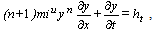 | (1) |
Table 1. Basic information about catchments of Zakapathians water-balance station
 |
| |
|
 | (2) |
where  is a depth of a stream;
  is a deviation of a slope surface;
  are parameters of a flow velocity formula;
  is a waterforming intensity;
  is a rain intensity;
  is a constant rate of infiltration;
  is a parameter infiltration associated with moisture;
  is a rate reduction, which is equal to 0.667;
  is time.Hillslopes modules (Ivanenko A.G. 1986, 1998)[10, 11] are calculated depending on a depth of a surface runoff and a subsurface runoff.
 | (3) |
 | (4) |
where  ,
,  are surface and subsurface modules;
  is a parameter, which depends on a macropore layer of soil, the diameter and cross section particles of soil;
  is a coefficient of a drainage water loss;
  is an average length of a hillslope.A total inflow of the module is calculated as
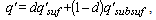 | (5) |
where  is a total module of a hillslope inflow;
  is a part of the catchment area, which is formed by a surface runoff.
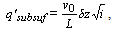
3.2. The Model of a Hillslope Washing Sediments
The equation of continuity of washing sediments from unit width a surface was used as a basic equation (Kondratiev S.A. 2007)[7]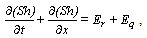 | (6) |
 | (7) |
 | (8) |
where  is a depth-average concentration of sediments;
  is a depth and a total module of hillslope inflow;
  are functions of the supply of sediments under the influence of precipitation;
  is a rain intensity;
  are empirical coefficients;
  is a transport capacity.
3.3. The Model of a Water Flow
The kinematic wave equation was used for simulation of a water flow in a river channel[10] | (9) |
 | (10) |
where  is a cross-section averaged water discharge;
  is a hillslope runoff discharge;
  is a cross-section area;
  is a wave velocity;
  is a channel parameter, that depends on the roughness and a shape of a channel;
  is a total length of a channel;
  is a distance from the river before the first channel control;
  is a deviation of the river;
  are empirical parameters.Numerical solution of these equations was done by finite-definite methods. Analytical solutions of mentioned equations (first of all – a kinematic wave equation) can be used as a basis for development of simple physically-based methods of runoff and substances wash out calculation.The model was tested and applied for the following catchments located in various geographical conditions and were supplied with various amounts of initial data: experimental catchments in Zakapathian, the North-Western Black Sea Region (Ukraine) and Moldovian (Republic of Moldova), small catchments of the northern part of Vietnam and others.
4. Results of a Model Application
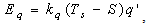
Materials of monitoring runoff and precipitation of ten catchments of Zakapathians water-balance station were used to realize this model. In the process of calculations more than 60 hydrographs of floods were optimized. The parameters of the described model were estimated by the method of dialogue optimization. Optimization was carried in a few stages. Optimum parameters were connected with the physic-geographical characteristics of the catchments as a result:1. Minimum intensity of infiltration for a surface runoff  =0.0054 mm/min and a subsurface runoff =0.0024 mm/min, which were common to all catchments.2. Parameter
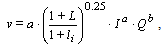
  characterizes the part of a surface runoff on the hillslope. It was connected with the average forest cover (in fractions of unity)
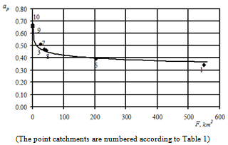
  (Figure 1)
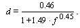 | (11) |
 | Figure 1. Dependence of the part of a surface runoff from the average forest cover |
3. Channel speed parameter  was connected with the catchment area
  (Figure 2)
 | (12) |
 | Figure 2. Dependence of the optimum parameter from the catchment area |
4. Parameters of surface runoff speed  and subsurface runoff speed
  are equal to
  =0.032,
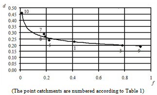
  =0.69.5. Parameter of formula infiltration of surface runoff
  was connected with an index of moisture
  (Figure 3)
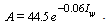 | (13) |
The results of a comparison of the obtained hydrographs and the actual data showed the possibility of applying this model for the calculations of the water flow and the sediments flow for the rivers of this region (Figure 4).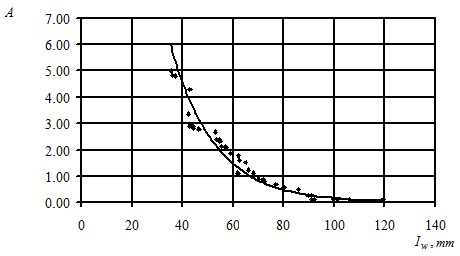 | Figure 3. Dependence of parameters of formula infiltration of surface runoff of the index of moisture |
Such indicators of quality of the process optimization were used in this work:- A value of the quality criterion  where
where  is an actual water discharge;
  is a calculated water discharge;
  is ordinates of the hydrograph.- A value of the efficiency method criterion
  .- A time shift of the actual and calculated maximum of the discharge
  .
.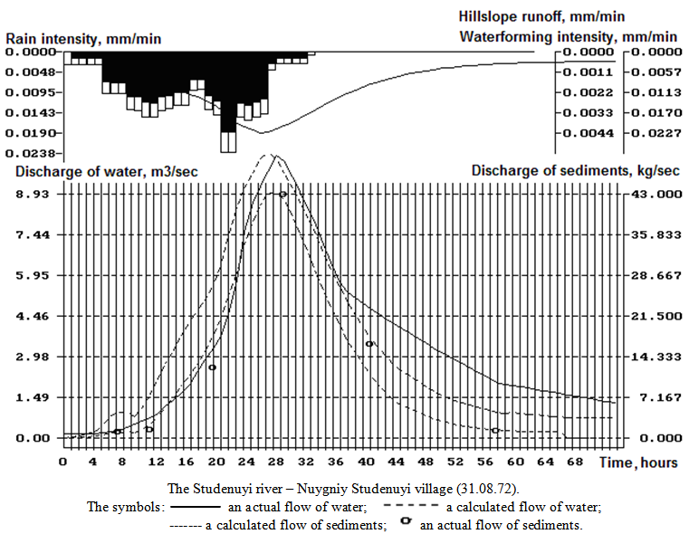 | Figure 4. Complex graph of the water and the suspended sediments flow |
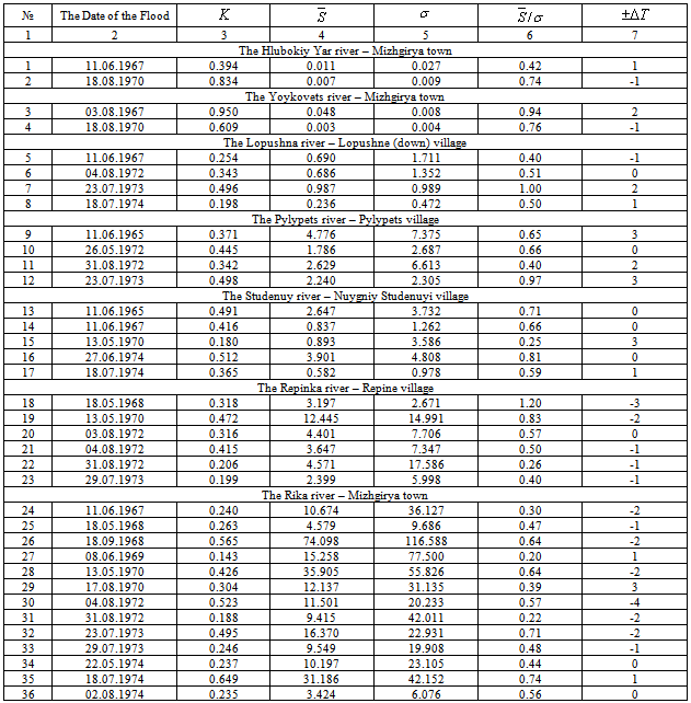
The results of calculation of the indicators of quality of the process optimization for some catchments of Zakapathian water-balance station are shown in Table 2.
5. Conclusions
Thirty six floods were used for optimization, in 30 cases, representing 83.4% of a total number of floods, we obtained a value of the efficiency method criterion of  <0.80. These calculations are classified as satisfactory. In half of these cases values
  <0.50 were obtained, so these calculations are qualified as good, 6 cases that remained, or 16.6% are classified as poor (Table 2).The values of a maximum deviation discharge and layers of a flow, on average, are equal to
  =1.76% and
  =16.1%, the value of a quality criterion
  =0.39 and the criterion of an efficiency method
  =0.59.The calculation of probability deviations of the calculated maximum discharge to actual showed the calculations can be considered reliable, because the deviation of a maximum discharge is up to 10% with probability at 97.2%.
Table 2. Values of a quality criterion calculation of the hydrographs and the criterion of an efficiency method
 |
| |
|
Verification of this model on an independent material showed approximately identical exactness of calculations for controls and optimization floods. The results of the comparison of calculated and actual hydrographs of a river flow were shown that the model’s parameters were chosen well. A model of a kinematics wave with optimum parameters is possible to be used for the calculations of hydrographs of a water flow and suspended sediments on the rivers of a region.
References
| [1] | Виноградов, Ю. Б., 1998, Математическая модель “Сток – эрозия – загрязнение”, Метеорология и Гидрология, 5, 87-96. |
| [2] | Назаров, Н. А., 1996, Оценки эрозионного смыва почв и выноса биогенных веществ с поверхностным стоком талых и дождевых вод в речном бассейне, Водные Ресурсы, 23(6), 645-652. |
| [3] | Неаринг, М. А., Булыгин, С. Ю., Котова, М. М., 1998, Первичная верификация и адаптация модели WEPP для условий Украины: проблемы, пути решения, перспективы, Почвоведение, 1, 96-99. |
| [4] | Лэйн, Л. Д., Ренард, К. Г., Фостер, Г. Р., и Лафлен, Д. М., 1997, Разработка и применение современных методов прогноза эрозии – опыт Министерства сельского хозяйства США, Почвоведение, 5, 606-615. |
| [5] | Lane, L. J., Nichols, M. H., Paige, G. B., 1995, Modeling erosion on hillslopes: concepts, theory and date, Proceedings of the International Congress on Modeling and Simulation (MODSIM’95), Newcastle, New South Wales, Australia, 1-7. |
| [6] | Singh, V. P., and Woolhiser, D. A., 2002, Mathematical Modeling of Watershed Hydrology, J. of Hydrology Engineering, 7(4), 270-292. |
| [7] | С. А. Кондратьев, Формирование внешней нагрузки на водоемы: проблемы моделирования, С.-Петербург, РФ: Наука, 2007. |
| [8] | А. А. Светличный, С. Г. Чёрный, Г. И. Швебс, Эрозиоведение. Теоретические и прикладные аспекты, Сумы, Украина: Университетская книга, 2004. |
| [9] | Бефани, А. Н., 1958, Основы теории ливневого стока, Труды ОГМИ, XIV(4), 5-304. |
| [10] | Иваненко, А. Г., 2001, Описание смыва загрязняющих веществ с малых водосборов, Метеорологія, Кліматологія та Гідрологія, 42, 168-178. |
| [11] | A. G. Ivanenko, and M. E. Daus, “Rainfall runoff spatial modelling on the base of rainfall radar measurements,” in Proc. International Conference of Headwater Control IV: Hydrology, Water Resources and Ecology in Headwaters (“HeadWater’98”), 1997, p.12. |
 Abstract
 Reference
 Full-Text PDF
 Full-text HTML