-
Paper Information
- Paper Submission
-
Journal Information
- About This Journal
- Editorial Board
- Current Issue
- Archive
- Author Guidelines
- Contact Us
Resources and Environment
p-ISSN: 2163-2618 e-ISSN: 2163-2634
2012; 2(6): 281-290
doi:10.5923/j.re.20120206.06

Mechanisms of Groundwater Pollutants Transport in Tulkarm Area / Palestine
 Abstract
 Reference
 Full-Text PDF
 Full-text HTML
Saed Khayat 1, Amer Marei 2, Basel Natsheh 1, Nawaf Abu-Khalaf 1
1Palestine Technical University (PTUK), Tulkarm, Palestine
2Environmental Research Lab., Al-Quds University Abu Dis, East Jerusalem, Palestine
Correspondence to: Amer Marei , Environmental Research Lab., Al-Quds University Abu Dis, East Jerusalem, Palestine.
| Email: |  |
Copyright © 2012 Scientific & Academic Publishing. All Rights Reserved.
This work is licensed under the Creative Commons Attribution International License (CC BY).
http://creativecommons.org/licenses/by/4.0/

This study aims at investigating the mechanisms of pollutants transport based on geological formations. The study classifies two sub-aquifers groups. The first group are wells which dogged within Senonian Abu Dis formation, and are mostly used extensively for municipal purposes. The second group are wells dogged with the most top Jerusalem-Hebron formation of Turonian age and mostly used frequently for irrigation purposes. The first group shows a high deteriorated water quality with ionic molar ratios bears the ratios from Wastewater stagnant in adjacent Zomar stream. The stream bed lays directly over Jerusalem formation which promotes the pollutant transport directly to the uptake zone. However, the effect of such stagnant become less in dilution time of winter. Septic tanks surrounded these wells are constructed within the top 5 meters of Senonian formation, which mean that the leakage from septic tanks is not that ease to significantly affect the groundwater quality. The second group are mostly subjected to direct rainfall infiltration this can be indicated through the higher Sodium values which are related to the ion exchange through limestone profile. The results emphasize the need for further procedures to mitigate the pollutants plume migration from Wadi to the surrounded environment.
Keywords: Groundwater, Pollution, Palestine, Tulkarm, Karst, Stagnant Water, Transoundary Pollution
Cite this paper: Saed Khayat , Amer Marei , Basel Natsheh , Nawaf Abu-Khalaf , Mechanisms of Groundwater Pollutants Transport in Tulkarm Area / Palestine, Resources and Environment, Vol. 2 No. 6, 2012, pp. 281-290. doi: 10.5923/j.re.20120206.06.
Article Outline
1. Introduction
- Water is one of the most valuable natural resources in the Middle East. The combination of multiple factors, e.g. population growth, economic and agricultural development, and an arid climate, result in over exploitation of the water resources in the region. The continuous high water demand leads to rapid degradation of the quality of fresh water resources as a result of the salinisation and contamination processes[1-3]. The lack of sufficient water, combined with rapid water quality deterioration, presents a serious challenge to the people in the region. In order to manage and share the water resources under conditions of accelerating degradation, it is crucial to understand the origin and mechanisms of the contamination process.The salinity that threatens the fresh water resources is derived from different sources, both natural and anthropogenic. In general, over exploitation of fresh aquifers results in a rapid decrease of water level, which then triggers lateral as well as upwelling of deep saline water from adjacent waters from aquifers. Consequently, the overexploited aquifers become saline due to mixing with salinewaters[1-4].Tulkarm area is located in the north western part of the West Bank. The water resources in the district is limited and restricted only to the shallow aquifer that is subjected to various sources of pollutant ion.Groundwater in Tulkarm City is being utilized through 10 domestic and 53 irrigation wells with total discharge of 21 MCM per year[5]. Most of the wastewater from the local communities to the east of Tulkarm drained through long stream that extended from Nablus city to the east across Tulkarm city to the Midetranean Sea. The wastewater stream part that pass from Nablus through Tulkarm is called Wadi Zomar. The main objective of this study is to investigate the role of different geological formations in facilitating the transport of the pollutants from Wadi Zomar and different anthropogenic sources surrounding Tulkarm city in Palestine.
2. Study Area
- Tulkarm area is located in the north western part of the West Bank - Palestine (Figure 1). The total area of Tulkarm is about 246 km² and its current population is estimated at 166,832 people, representing 12.4% of the total population of the West Bank[6]. Tulkarm lies on the western slopes of the West Bank, which are characterized by gentle slopes. The elevation in the city ranges between 50 to 180 meters above sea level.
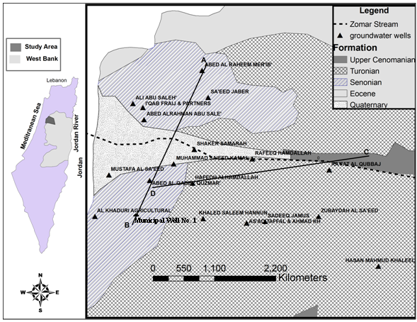 | Figure 1. Study Area of Tulkarm, sampled wells are shown with the different geological formations |
2.1. Geology
- The geological formations of the study area of Tulkarm range in age from Senonian to Quaternary. The stratigraphic section of the West Bank is present in (Fig.2)[18]. The district is mainly covered by sedimentary carbonate rocks such as limestone, dolomite, marl and chalk. The general geology of the Tulkarm area is represented in Figure 1. A brief description of the lithological formations encountered in the Tulkarm district is presented below[18-20].
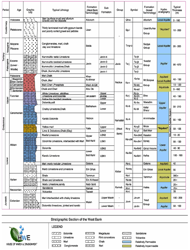 | Figure 2. Stratigraphical section of the West Bank (Source:[18]) |
 | Table 1. Hydrochemistry of the Pleistocene Wells and springs from Jericho-Palestine area in (mg/l) |
2.1.1. Upper Cenomanian
- The Upper Cenomanian formation (also known as the Bethlehem formation) consists of limestone, dolomite with some chalk, and marl. Outcrops are found mainly on the flank of the A’nabta anticline. The dolomite forms a rugged morphology on gentle slopes.
2.1.2. Turonian
- The Turonian formation (also known as the Jerusalem formation) consists of a series of massive, thick- to- thin bedded limestone to dolomitic limestone and dolomites with a thickness of approximately 70-130 m. The lower part of the Turonian formation consists mainly of limestone and dolomite with marl and some chalk, making it sometimes difficult to be distinguished from the underlying Bethlehem formation. Towards the top of this formation, chalk beds with occasional chert bands are common, and the formation is transitional to the overlying chalk facies. The Turonian formation has a well-developed karst feature and is commonly used as a building stone. It is exposed in the A’nabta anticline and is considered a very good aquifer.
2.1.3. Senonian
- The Senonian formation (also known as Abu Dis formation) is mainly made up of Cretaceous Rocks, which are composed of chalk, ranging in age from the Coniancian at the bottom to Paleacene at the top. Outcrops exist in the A’nabat anticline and on the western limb of Nablus-Beit Qad syncline. In the Tulkarm city area, the chalk is thin and consists of marly base and passes upwards through bedded and crystalline limestone that has few marl partings.
2.1.4. Quaternary
- Quaternary rocks are divided into the following formations:a. Lisan Formation: these recent sediments are mainly composed of alluvium consisting of bedded limestone, chert and clay. The thickness of these sediments varies from one place to another. The rock fragments comprising the deposits are mainly derived from rock formations adjacent to the wadi area.b. Nari Formation: it occurs mainly in high rainfall areas where carbonate rocks are dissolved by percolating water. It forms a thin coating over the limestone.
2.2. Hydrogeology
- The Tulkarm district is underlined hydro-geologicaly by the northern part of the western groundwater basin. It is located in the semi-coastal region. Groundwater flow is directed towards the west and northwest.
2.2.1. Aquifer System
- The major aquifers in the area are the Shallow Aquifer and the Upper Cenomanian- Turonian complexes. The Abu Dis acts as an aquitrad hence, forming a water barrier. Since the Upper Aquifer is the predominant aquifer in the region, it is described in full below[19,20].
2.2.1.1. The Upper Aquifer System
- The Upper Aquifer is represented by the formations of the age Turonian (Jerusalem formation) and Cenomanian (Bethlehem and Hebron formations).
2.2.1.2. Turonian Aquifer
- The Turonian aquifer is part of the Upper Aquifer but can be classified as a distinct local aquifer if the formation beneath it acts as an aquitard as is the case in some areas in the eastern and southern parts of the West Bank. The Turonian aquifer is considered a fairly good aquifer especially where the saturation thickness is in tens of meters. This aquifer is of good thickness and extent in the Tulkarm area (approximately 130 m thick). The water quality of this aquifer is generally good but in some areas there is evidence of deterioration because of sewage and agro-chemical pollution.
2.2.1.3. Cenomanian Aquifer
- The formations of this aquifer are the Bethlehem and Hebron. The aquifer is an important regional source of water supply for domestic use. The Cenomanian Aquifer has high recharge values. It is heavily exploited in the areas near Tulkarm and Qalqilya because the aquifer is at a shallow depth in this area. The depth to water is rarely more than 200 m below ground surface.
3. Data Collection and Method
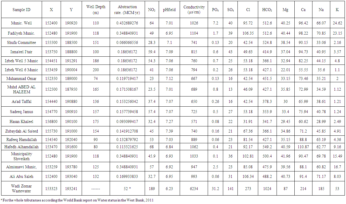
- The original aim of groundwater sampling was based on providing a supplement analyses to investigate the gradient of pollution for the aquifer system, according to spatial distribution and the effect of the pollution plume surrounded the wastewater stream banks. For this purpose, 17 samples from springs and wells, distributed in different geological outcrops, were collected. The samples were collected in December 2011 (wet season), sampling localities are shown in Fig. 1. Other samples for Nitrate and potassium were obtained 4 months earlier by the end of the dry season.Onsite measurements for physicochemical parameters (pH, temperature, m-value and redox potential) were done. The samples for anions were preserved using HgCl2 for prolonged preservation of nitrate. For accurate chloride measurement, the chloride concentration was measured out from the water samples of the cations[3]. Due to the fact that samples were collected in the agricultural season, all the sampled wells had been pumping for a long period of time. Hence, no further purging was needed prior to sampling and the samples were collected immediately. Samples for (Cations and Anions) were collected in 250 ml polyethylene bottles.Major anions (NO3, SO4, PO4 and Cl) were analyzed using HP liquid chromatography. Concentrations of the major cations (Ca, Mg, Na, and K) were determined by ICP-OES. Alkalinity and HCO3 analysis was measured onsite by titration[21,22]. All chemical analyses were carried out at the Environmental Research Lab. at Al-Quds University – Abu Dis.
4. Results
- The chemical data are shown in Table 1. The major cations and anions concentrations of the groundwater from the sampled wells in the study area are plotted on a piper diagram (Figure 3).The water type is normal earth alkaline water with prevailing bicarbonate for one group and prevailing chloride in other group. The water type varied from Ca-Mg-HCO3 which shows less susceptibility to pollution to those have Ca-Mg-Na-HCO3-Cl for those wells with high pollutants, the last type bears the sample from Wadi Zomar wastewater (Figure 3). However, both groundwater types reflect dolomite bearing rock from Turonian and sometimes the deeper cenomanian formations.In general the results shows different NO3 values in all samples that varied from 64 mg/L in winter season and 81 mg/L in summer season for municipal wells, to 23 mg/L in Muhammad Omar agricultural well. In general most of the nitrate vales exceed the WHO standard for safe drinking water which is 50mg/L. While other anthropogenic related ions show variable values which exceed in many cases the WHO standard for drinking water and follow the surrounded activities and the characteristics of the aquifer geology as it will be described in further details later on in the following section.
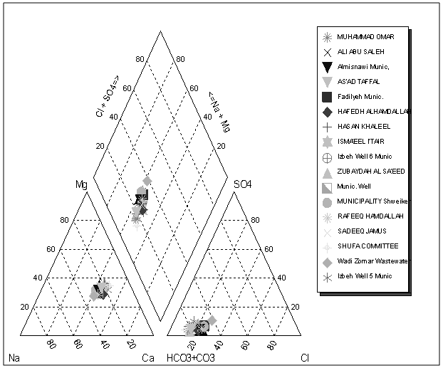 | Figure 3. Durov Plot suggests the trend of water from fresh Ca-Mg-CO3 water in some wells NA-Mg-Cl water in others that are bearing the Wadi Zomar value |
5. Discussion
- In general, many previous studies for the water quality in the study area show that there is a big pollution problem with sewage especially for municipal wells which used for domestic purposes. These studies mostly refer the problem of groundwater pollution in the area to the seepage from the septic tanks[9-16]. This study shows that these previous results are partially true. In this study, we tried to make further geological investigation to build a conceptual model for pollutants transport, whether it was from septic tanks or from Wadi Zomar. There are some other studies taking Wadi Zomar as environmental hazards for the surrounding communities from Nablus to the trans-boundary area across green line to the Israeli areas[15,17]. However, the question about the mechanism of pollutants transport from the Zomar stream to the surrounded environment still open. The hydrochemical data from the groundwater in sampled wells surrounding Tulkarm city, show two dominant groups that have different magnitude in pollution and pollution type. In general the high pollution was recognized in the wells that have higher abstraction rate, mainly those wells that used at daily basis for domestic purposes. According to piper diagram those municipal wells group characterized by higher Na and Cl values that are more closed to those values taken from Wadi Zomar stream (Figure 3). The other group has less Cl content and more Na than chloride which might be due to ionic exchange during the process of recharge (Figure 4). In this context, it is worthy to mention that most of the wells exposed to normal softening are covered with Turonian outcrop which promote the direct infiltration through surface, unlike the other group that is mostly covered by impervious chalky Senonian formation.The hydrochemical data classified the sampled wells into two groups which are subjected mainly to three pollutants sources (Figures 3, 4, 5). In general the pollutants sources varied according to the geological outcrop, and surrounded activities. These sources can be summarized as follow:
 | Figure 4. Na vs. Chloride and Na/Cl molar ratios in the samples wells shows 2 major groups, one with high Na and Cl the same as in Wadi Zomar, and the other with relatively lower values |
 | Figure 5. K/NO3 molar ratio versus PO4 in mmol/L, classified the samples into Wadi Zomar affected group, septic tanks affected group and wells with mixing effects |
5.1. Wadi Zomar
- Wadi Zomar is considered one of the largest wastewater streams that hold the wastewater from the surrounded communities and extend from Nablus city in the east and cross the green-line boundary to Israeli settlements across Tulkarm area. The problem of Wadi Zomar stream varied spatially and temporally, according to the season and the distance from the wastewater inlet and the slope[17]. Two geological profiles in the study area were created depending on the wells lithology (Figures 6, 7). The profiles show that most of the wells in the study area are drained from the Turonian- Cenomanian layers (Jerusalem-Hebron formation) (Figures 2). The Turonian Jerusalem formation is exposed in the area surrounded the Zomar stream, while the Cenomanian Hebron formation is found on the flank of the A’nabta anticline upper part of the stream (Figure 1, 2, 6, 7). The direct seepage from Hebron formation allowed the sewage to mix directly through with fresh recharge water and leaks to the zone of uptake (Figure 7).
 | Figure 6. Concentration of Potassium and Nitrate (in mg/L) in Summer and Winter season, show an increase in concentration in the dry season |
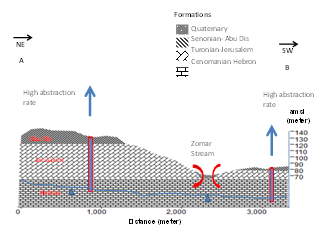 | Figure 7. A-B geological cross section from the North East to the South West of the study area |
 | Figure 8. C-D geological cross section from the East to the West of the study area |
5.2. Septic Tanks
- As mentioned above, several studies and reports connected the problem of high nitrate in the groundwater from the study area to the septic tanks distributed over the study area. Septic tanks, naturally, play an important role in the pollution process but the complete story is not only related to the septic tanks and it is not definitely the main cause of groundwater pollution as this study pinpoint. The data of this study suggest more important role for Wadi Zomar in the pollution process rather than the effect of cesspits. As mentioned above, this suggested role for the Wadi Zomar is clear in the wells of high abstraction rate and which are dogged in the impervious layers of Senonian (Figure 1). Normally septic tanks are present in the top 5 m below surface; therefore, the evidence of leakage from septic tanks through the Chalky Senonian layer is very low. However, a significant evidence of pollution from septic tanks was noticed in the wells dogged in the Turonian layer, these wells shows higher nitrate over Potassium values with relatively low PO4 which found higher in wastewater from Wadi Zomar (Figure 5). These wells (dogged in Turonian) also show surplus Na in most cases which might indicate softening during the direct recharge through Jerusalem formation or might due to additional source of Na from Septic tanks with Na/Cl molar ratio higher than this ratio taken from Wadi stream (Figure 4).
5.3. Agricultural Activities and Irrigation Feedback
- The protected agriculture is widely common all over Tulkarm area, where the drip irrigation practices are mostly used; however, some farmers are still using direct water application for irrigation. Moreover, there are a lot of agrochemicals and fertilizers applied in considerable amount in the study area[10]. In general, there are many indicators about the presence of irrigation feedback to the groundwater. Most of the farmers use Potassium nitrate and natural manure as fertilizers. This resulted in a surplus amount of potassium and nitrate in the groundwater. However, the data shows a wide range of both potassium and nitrates in the groundwater samples. In this context, it was difficult to differentiate between those values that are coming from the pollution plume of the Wadi Zomar, septic tanks or the agricultural feedback. Figure 5 shows that there are some wells (s. a. Rafeeq Hamadallah, Izbeh wells, and Ismael Itair) which are less affected by Zomar sewage plume, where the contribution of agricultural pollutants are clearer with higher potassium and relatively low PO4. This means that most of the wells are subjected to such kind of pollution, but the presences of more effective sources are dominated over the agricultural sources.
6. Conclusions
- The problem of groundwater pollution in the upper aquifer of Turonian Cenomanian age is the most common problem for the groundwater in the study area. Previous studies connected the source of pollution by the presence of common used septic tanks, agricultural activities and to limited extend the wastewater discharge in Wadi Zomar. Unlike other studies, this article classifies the pollution sources and the predominance effect of each source on each wells group. The study connects the different mechanisms of pollutants transport to the different geological pollution that characterize the surrounded aquifer media. In general, the study classifies two wells groups according to its location within geological outcrops. These are wells which dogged with the most top Senonian Abu Dis formation, which are mostly municipal with high daily abstraction rates, and the wells dogged with the most top Turonian Jerusalem formation and mostly used frequently for irrigation purposes. The first well group show a high deteriorated water quality that mostly related to the pollutant transport from Wastewater stagnant in Wadi stream. The stream bed lays directly over Jerusalem formation which promote the pollutant transport directly to the uptake zone of these wells (especially municipal one with high abstraction rate), and overcome any other pollution sources that might affect the quality of groundwater in these wells. Moreover, the septic tanks surrounded these wells are present in the most top 5 meters of impervious Senonian Abu Dis formation, which mean that the pollution from septic tanks has less effect on the groundwater from it. Moreover, the flatten slope of the Wadi stream surrounding Tulkarm enhance the formation of wastewater stagnant that infiltrate slowly through the alluvial deposits to Jerusalem formation and finally to the surrounded aquifer. The formation of such wastewater stagnant is mostly predominant in Sumer season with the absence of sufficient waste dilution or precipitation runoff that wash out the Wadi flow. On the other hand, the second wells group shows higher sodium values which are related mostly to the ion exchange or softening that occurs with direct infiltration through Jerusalem formation cover the top of these wells locations. However, this group show less values of pollutant, and accordingly the effect of other pollution sources was easily noticeable. This group characterize by more effect from the septic tanks, then the pollutants from irrigation feedback.
7. Recommendations
- The process of pollutants plume migration from Wadi Zomar through the geological formations to the adjacent uptake zone, can be controlled through lining the wastewater stream with suitable impervious material that prevent the leakage from the Wadi along the Stream path. The daily heavy abstraction rate from the adjacent municipal wells must be regulated and the change in water quality should be monitored with respect to fluctuation of water table.The effect of wastewater stagnant formation especially in summer season must be mitigated by injecting the stream with a suitable amount of treated wastewater that accelerate the stream flow and wash these stagnant out along wadi path.
ACKNOWLEDGEMENTS
- We express our deep gratitude for Tulkarm Municipality for their cooperation in completing this work. In this regard we express our deep thank here to Eng. Rayek Hamad and Mr. Nidal Alshen from Water department in Municipality for all assistant and cooperation in field and providing data. The authors also would like to thank the Palestine Technical University-Kadoorie for providing financial support to publish this work.