-
Paper Information
- Previous Paper
- Paper Submission
-
Journal Information
- About This Journal
- Editorial Board
- Current Issue
- Archive
- Author Guidelines
- Contact Us
Marine Science
p-ISSN: 2163-2421 e-ISSN: 2163-243X
2013; 3(3): 91-99
doi:10.5923/j.ms.20130303.04
Public Perception of Tidal Flooding Hazards on Bonny Island, Rivers State; Nigeria
 Abstract
 Reference
 Full-Text PDF
 Full-text HTML
Akuro E. Gobo1, Gordon T. Amangabara2, Williams.W. Pepple1
1Institute of Geosciences and Space Technology, (IGST), Rivers State University of Science and Technology P.M.B. 5080, Port Harcourt, Nigeria
2Department of Environmental Technology, Federal University of Technology, P.M.B. 1526 Owerri, Nigeria
Correspondence to: Akuro E. Gobo, Institute of Geosciences and Space Technology, (IGST), Rivers State University of Science and Technology P.M.B. 5080, Port Harcourt, Nigeria.
| Email: |  |
Copyright © 2012 Scientific & Academic Publishing. All Rights Reserved.
International research efforts by organizations such as IPCC have revealed past trend of global warming and its future. Based on these estimates, there is justifiable expectation that climate change and sea-level rise could cause a wide range of impacts on coastal zones; some of the typical impacts identified are coastal erosion/ increased flood risk, and impacts on infrastructure. The current study analysed public perceptions of tidal flood hazards on Bonny Island, Rivers State; Nigeria. The focus of the study was to identify the most vulnerable areas on the Island to the tidal inundation as well as assess the local community adaptive capacity to the tidal surge. Based on a recognizance survey, we administered 270 questionnaires to 15 identified communities on the Island that constantly experience tidal floods. Results from the study showed that nearly two-third of the respondents (67.6%) in our study area had good knowledge of the causes, time of occurrence and impact of tidal flood on Bonny Island; that the flood coincides with the spring tides during the raining season which is responsible for its severity occasioned by the building of shanty-type houses within the waterfront and the swamp area resulting in flood pondages that can last for several days; The time it takes the floodwater to totally recede according to 77% of the people is 12hrs 45mins. Loss of life, household property, business time, sicknesses resulting from flood ponds that breed diseases vectors etc are some of the impacts reported by the people. The study also showed that there are no effective mitigation and adaptation strategy put in place in the event of a catastrophic ocean surge. No early warning, no community education as a result respondents show a great level of indifference to the impact caused by the flood by their attitude and lack preparedness.
Keywords: Public Perception, Tidal Flood, Hazards, Vulnerability Assessment, Okrika, Bolo, Bonny Island
Cite this paper: Akuro E. Gobo, Gordon T. Amangabara, Williams.W. Pepple, Public Perception of Tidal Flooding Hazards on Bonny Island, Rivers State; Nigeria, Marine Science, Vol. 3 No. 3, 2013, pp. 91-99. doi: 10.5923/j.ms.20130303.04.
Article Outline
1. Introduction
- Flooding is the most common of all environmental hazards and it regularly claims over 20,000 lives per year and adversely affects around 75 million people world-wide[1]. The reason lies in the widespread geographical distribution of river floodplains and low-lying coasts, together with their long standing attractions for human settlement[2]. Death and destruction due to flooding continue to be all too common phenomena throughout the world today, affecting millions of people annually; Thus, The International Decade for Natural Disaster Reduction (IDNDR) was launched by the General Assembly of the United Nations in 1987 to run from 1990 to 2000. With the aim of reducing the loss of life, property damage, social and economic disruption caused by natural disasters[3]. The resolution proclaiming the Decade makes specific reference to flood, tsunamis, drought and desertification among the principal disasters to be considered. As already stated flood is a devastating phenomenon causing loss of human life and damages to property[4, 5, 6] about one third of all deaths, one third of all injuries and one third of all damage from natural disasters are attributable to flood[3].Flood also has its benefit if properly and efficiently managed[7]. Floods can occur due to intense, long duration rainfall events[8] and also as a result of extremely high over bank discharge from rivers and other water bodies[9]. In the literature, different types of floods that occur in the Niger Delta have been identified e.g. urban floods, flash floods, channel floods, Back-swamp floods and coastal inundation/ tidal floods[5]. However, the prevalent flood event that poses serious threat to life and property on Bonny Island is tidal floods. This occurs when the sea level rises to a critical height above the coastal lands with weak defences especially during the raining season and at periods of astronomical spring tides and inundates settlements[9,10]. It is an annual event affecting most Niger Delta communities like Port Harcourt, Yenagoa, Okrika, Bolo, Opobo, Buguma in Rivers State; Twon-Brass, Igbematuru, Olugbobiri and Peremabiri in Bayelsa State amongst others.Outside the Niger Delta of Nigeria, tidal flood is reported to occur at Victoria Island, Lagos; Nigeria[11]. Globally, more than 100 million people are at risk of tidal flooding[12] countries like the Maldives, an archipelago of nearly 1196 low-lying islands[13], China, Honduras, Thailand[14,15], Mauritius[16] and many coastal cities in the Mediterranean, pacific, Atlantic, Australia and the Indian ocean are at risk.International research efforts such as IPCC have revealed past trend of global warming and its future, there is justifiable expectation that climate change and sea-level rise (according to[17] sea-level rise at Bonny is 1mm per annum) could cause a wide range of impacts on the coastal zones; some of the typical impacts identified are coastal erosion, increased flood risk, and impacts on infrastructure. Many regions of the world have commenced vulnerability assessments of the coastal areas. Vulnerability Assessment (VA) is essentially an analysis of the scope and severity of the potential effects of a disaster, in this case coastal flooding. This encompasses the assessment of both anticipated impacts and available adaptation options. At present a region-wide vulnerability assessment for the Asia and Pacific region has been initiated. Africa is perhaps, the only continent where no serious effort is presently on-going.Our existing knowledge on the vulnerability of coastal areas to tidal/coastal flooding vis –a-vis sea-level rise is poor and scattered, but all the evidence points to a severe impact potential. This raises fundamental questions which are pertinent to the United Nations Framework Convention on Climate Change (UNFCCC) about the ability of different nations and regions to adapt to sea-level rise. .The main objective of this study therefore was to highlight the areas on Bonny island that are most vulnerable to the tidal inundation while the specific objectives were to 1) assess and describe disaster preparedness behaviour among the people of the island and 2) the island adaptation capacity to the tidal surge; as understanding the impact of flood hazard to local community and people’s response to hazard are essential to addressing issues of concrete action in coastal hazard management. Research has shown that people with better knowledge and preparedness behaviour could help in preventing the severe losses and damages. However, there have been no studies conducted to identify the level of knowledge, behaviour and perception of the rural people towards disaster preparedness in the country. Hence, by studying the level of knowledge and disaster preparedness behaviour among rural islanders in Bonny will help authorities to take measures to mitigate and prevent tidal flood disasters in the future.
2. Study Area
- Bonny Island is approximately 40km South of Port Harcourt and on the leeward side of the Cameroon Mountain. It is the Administrative Headquarters of Bonny Local Government Areas of Rivers State, Nigeria (Figures 2 and 3) Grand Bonny, Finima, Opusunju, Kala Sunju, Green Iwoama and Kalaibiama are the major communities that make up the Island. The Island lies on the Lat. 4o27N and Long 7o10E with an estimated population of 270,000[18]. The Island has a relatively flat topography on an elevation of 3.05 atmospheric mean sea level with a total land area of 214.52m2[19] with about 70% of its size suffering from tidal flooding and land subsidence. The geology of the area comprises basically of alluvial sedimentary basin and basement complex. The sub strata of the island consist mainly of fine sands, down to about 10m with occasional clay layers.According to[20] Bonny Island has lost about 1,793.24 km2 of coastline between 1986 and 2006 with a greater percentage (76.62%) of this loss occurring between 1986 and 2001 coinciding with the massive constructions of NLNG, expansion of Shell export terminal and other anthropogenic influences as a result of influx to the small Island.Bonny Island is basically a rain forest vegetation area with brackish mangrove forest vegetation established at the banks of the Bonny River and its tributaries. The greater northern half up to the east of Bonny Town, next to the Opobo Channel is mainly mangroves, and lies just above sea level (Figure 3). The southern part lies higher and contains typically (degraded) freshwater swamp forests, in some places mixed with mangrove, open swamp, dry land rainforest or dune slacks[21]. The southern Atlantic coast of Bonny Island encompasses a beach ridge barrier and a sandy beach. The coastal situation is characterized by a large, 20 km wide, offshore sand bank: the Bonny Bar. It protects the coastline against ocean currents and waves. The island itself is dissected by several creeks.The tidal flood on Bonny Island causes inundation on the coastal settlement. The sea water area is extending to the land (as a result of the accompanying coastal erosion) leading to the loss of land and change to the coastline[20]. Resultant impacts include damages to structures, loss of lives and property, decreasing environmental quality which enhances health problem, e.g., malaria and yellow fever[22, 23, and 24]. In economic terms, tidal floods have vast implications for the economy of Nigeria as Bonny Island is host to several multi-billion dollar companies including the Nigerian Liquefied Natural Gas Company (NLNG), Shell Petroleum Development Company (SPDC) Export terminal and other oil company facilities like tank farms
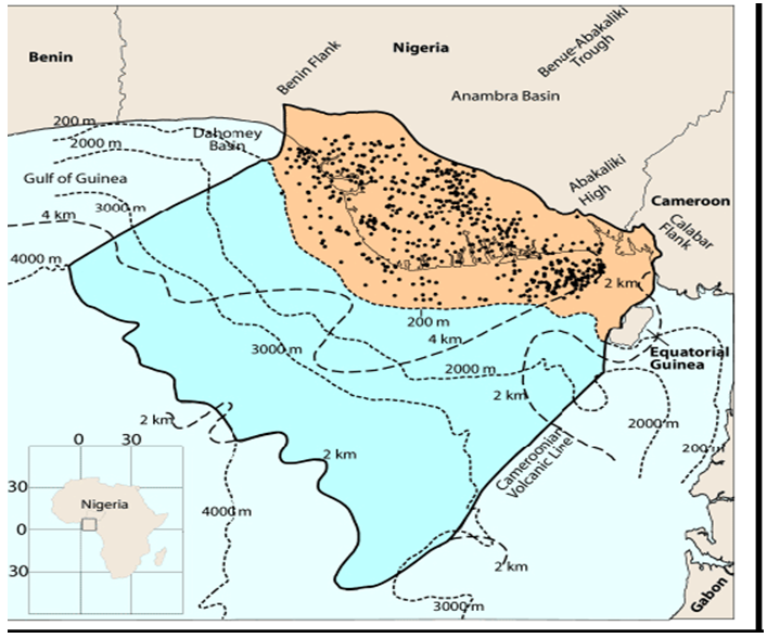 | Figure 1. Geologic formation of the study area[26] |
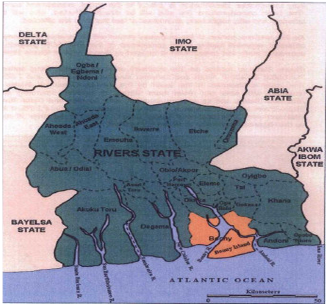 | Figure 2. Map of Rivers State showing the study are Bonny[Source: 26] |
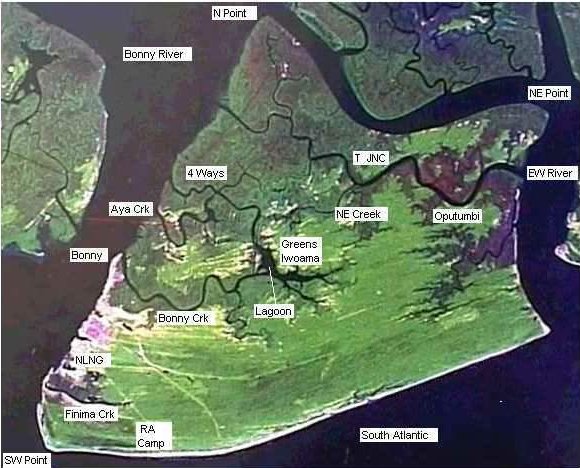 | Figure 3. Imagery of Bonny Island.[Source: 26] |
|
|
|
3. Materials and Methods
- A preliminary survey was conducted to ascertain areas of Bonny Island susceptible to the annual tidal inundation. Based on our findings, we administered questionnaires soliciting their perception to the occurrence of the flood. This method was also employed by[13] for the Maldives Islands Two hundred and seventy questionnaires were randomly administered in the fifteen identified flood prone areas. The questionnaire was pre-tested outside the study area and is made up of open and semi-structured questions which focused and sought information on knowledge of tidal floods, their causes, prevention and control, vulnerability, coping strategy as well as socio-economic cost to those affected. Questionnaire was administered to persons from the age of twenty with a minimum academic qualification of Basic (elementary) education and who must have lived or done business in the community for at least three years.
4. Results
4.1. Flooded Areas
- From our preliminary survey of monitoring tidal overflow, fifteen areas were identified within the period of our study as most vulnerable to tidal inundation and these areas arei. Macaulay Communityii. Sandfield iii. Coal Beachiv. Orosikiri v. Aganya Communityvi. Ayambo Communityvi. Perekunle Iwoama Communityviii. Igoni Poloix. Dappa Posiax. Hart House Compoundxi. Manila Pepple Compoundxii. Banigo Compound Akiamaxiii.Cable Roadxiv. Allison Compoundxv. Jackwilson Compound
4.2. Perception as the Cause of Tidal Flood in the Area
- On the perception on the causes of tidal flood in Bonny Island, 67.6% of the respondents opined that River overflow as a result of either land subsidence and/or sea level rise (spring tide) accounts for the regularity and severity of the tidal invasion. While 12% attribute the cause of the tidal overflow to the rainfall regime of the area. 18% of the respondents believe, the location of the community relative to the coast coupled with the construction of shanty-type settlement at the waterfronts is actually responsible for the tidal surge. 1.6% are rather of the opinion that climate change reflected in global warming is the likely cause of the increasing tidal surge on Bonny Island.
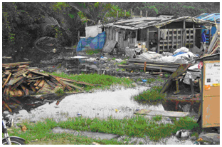 | Figure 4. Tidal Flood in a Shanty Area in Bonny Island |
4.3. Period and Duration of Tidal Surge
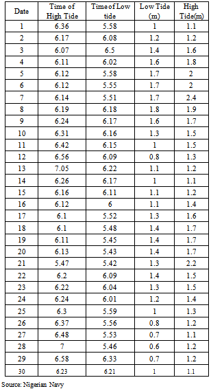
- 8% of respondents, claim that tidal inundation only occur whenever there is rainfall. 28.8% say tidal surge are localised to the raining season while 59.6% of the respondents claim that tidal surge occurs/coincide with the annual spring/neap tides as well as whenever there is severe rainstorm. On the duration (periods when the area is under water), 77.2% respondents say, floodwaters last as long the high tide (at least 12hours 45mins) while 18.4% say it last for a day 3.6% of respondents claim that flood waters form ponds/pool of water that last between one week and one month depending on the severity of the surge especially if such tidal overflow was occasioned by rainstorm.
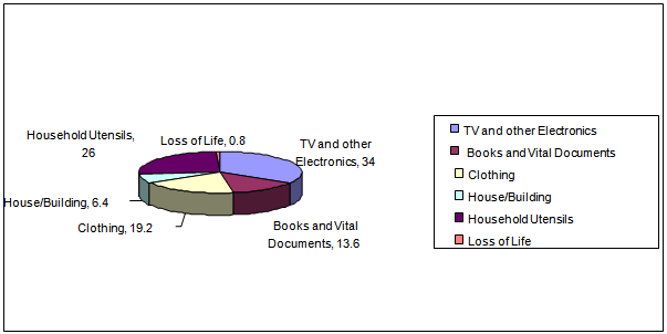
4.4. Impact of Flooding on the People
- The perceptions of people on the impact of tidal flood are in the areas of sickness (30%), shoreline loss/erosion (12.8%), Loss of business hour (18.4%) and impact on building in the form of reduction of building strength/loss of aesthetics value (38.8%) on the macro scaleWhile on the micro scale, 58% of respondents considered the loss of Household equipment/electronics as the most severe impact. Other impacts include Loss of clothing/wears (19.2%), damage/loss of books & documents (13.6%), collapse of building (6%) and loss of life (0.8%)
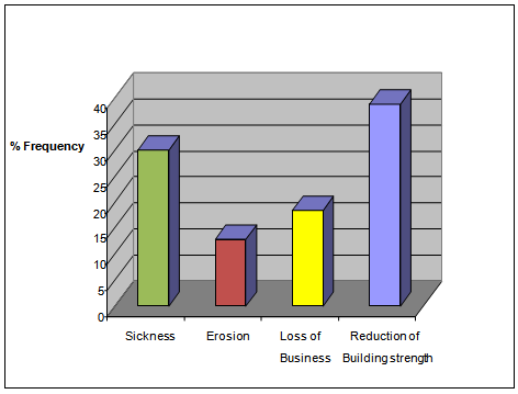 | Figure 5. Perception of respondents Observed impacts during Flood |
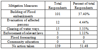
4.5. Adaptation Strategy/Mitigation
- People’s perceptions as to the strategy adopted in coping with the flood as well as the mitigation measures put in place by either government or those affected show the following interesting results
|
 | Figure 6. Loss of property to tidal flooding |
5. Discussion
- Our findings show that nearly two-third of the respondents (67.6%) in our study area had good knowledge of the causes, time of occurrence and impact of tidal flood on Bonny Island; that the flood coincides with the spring tides during the raining season which is responsible for its severity occasioned by the building of shanty-type houses within the waterfront and the swamp area resulting in flood pondages that can last for several days breeding malaria and other disease vectors. No similar studies have been conducted for Warri, Twon-Brass and Victoria Island Lagos, places where tidal floods occur in Nigeria, it becomes impractical to do some comparison. However, for countries in the Indian Ocean like Mauritius, the awareness is very high. It is reported that the country has a long history of natural hazards preparedness and early warning. The Cyclone and Natural Disasters Scheme in place was recently strengthened, taking into consideration the evolution in technology. The country has developed the capacity to reconstruct and repair basic infrastructure so as to ensure that the economic machinery gets back on rail as quickly as possible after a disaster. Similar Studies[13, 14, and 15] conducted in the Pacific region show that for Maldives, more than one-half of the respondents (58.7%) had good level of knowledge, slightly more than one-third (36.6%) had moderate level and only a few (4.7%) had low level knowledge. A large majority of the respondents (86.9%) had tidal flood experiences. For Thailand, the result is similar with about 60% having good knowledge of the occurrence and causes of tidal floods. There are some explanations to it. These countries experience tidal flooding quite frequently and the population had experienced tsunami just some few years back. However, there is some room for further improvement especially in preparing goods for tidal flooding On mitigation and preparedness, 37.04% responded to building of flood embankments. Other forms of preparedness such as flood forecasting and community education has zero respondents. This is in contrast to contrast in the Indian and Pacific coasts, perhaps as a result of repeated tidal flooding and tsunamis, for example, Slightly more than one-third of the respondents (34.7%) stated they attend community-based disaster preparedness activities, which included sharing information (39.2%), rehearsals (33.8%) and workshops (27%) were the main activities respectively and most of the respondents (86.9%) had received information about tidal flood through mass media. Regarding to source of information, 91.9 percent received from Radio, 69.2 percent received from Television, 16.2 percent from Newspaper, and 5.4 percent from Internet respectively in the islands in Maldives. These mitigation options are practically absent on Bonny Island.Given the strategic importance of Bonny to the Nigeria’s economy, it is puzzling to find out that there is no effective flood forecasting measure on Bonny Island. It is estimated that the threat of coastal flooding is increased by the prospects of a global sea level rise, that a one meter sea level rise in Nigeria could flood 18,000km2 and damage assets valued over US$9 billion, and force the relocation of up to 3.7 million people[19, 28].The damaging effects of floods are complex. Floods frequently cause major infrastructure damage, including disruption to roads, electricity supply systems, water supplies and sewage disposal systems. The economic effects of floods are often much greater than indicated by the physical effects of floodwater coming into contact with buildings and their contents. Indirect economic losses typically spread well beyond the flooded area and may last much longer than the flood itself. The local and regional economy may be badly affected by a major flood disaster and this may seriously affect the national economy.The necessary organs of government should promulgate policies that could enhance standard building and monitoring. Furthermore, flood disaster prevention must be based on clear and forceful policy which is consistent with economy, social and environmental policies. As flood disaster measure requires considerable financial resources. A developing country such as Nigeria with limited financial resources should give emphasis to policies which steer development away from high risk area. Land use control and building codes play an important part in this regard. The traditional essential element of flood disaster prevention includes legislation, risk evaluation, land use and zoning building code and constructional measure for flood control. Before, during and after a flood event, activities may be undertaken by the population at risk, the policy makers and by emergency workers such as National Emergency Management Authority (NEMA) in order to reduce health risks. Traditionally, the fields of engineering and urban planning aim to reduce the harmful effects of flooding by limiting the impact of a flood on human health and economic infrastructure. This is accomplished by following construction codes and legislations aimed at relocating structures away from flood prone areas, planning appropriate land use and managing costs of floodplains. Mitigation measures may reduce, but not eliminate major damage. Early warning of flooding risk and appropriate citizen response has been shown to be effective in reducing disaster-related deaths[28, 29].Where feasible and cost-effective, flood alleviation schemes also may be considered, along with development control, to restrict new building in the floodplain. Awareness of issues relating to flooding and health needs to be raised among the various authorities involved in improving response to, and recovery from, flood events, e.g. local government councils, the Environment Agency, the Ministry of Environment, National Emergency Management Agency (NEMA) and their State counter-parts. Systems of social support for flood victims during the recovery process may prove to be important in mitigating some of the mental and physical health effects resulting from flooding. These systems may include organization of teams of volunteers to help clean up properties after a flood (especially for the elderly or those living alone), the provision of child-care facilities for parents to allow them to concentrate on the recovery process, advise on insurance claims and building contractors and general counselling services to help people to cope with their experiences.
6. Conclusions
- The generality of people living on the Island of Bonny are aware of the causes and timing of tidal floods in Bonny, however, they are at lost on what to do when this event occurs. The people suffer losses during floods ranging from loss of life, sicknesses and diseases to loss of man-hours in business, household property etc. and Although factors such as flood warning, coping strategies and social support may mediate the stressful effects on people's health, these factors are either weakly developed or non-existent. When flooding is unexpected, sudden and without warning, especially when there is no adequate public education, mere awareness of the occurrence of tidal or indeed any other type of flooding without adequate preparedness to overcome the challenges still predisposes the people to the hazards associated with floodsRecent years have seen a shift in emphasis associated with flooding from disaster response to preparedness and mitigation, and from the provision of services to more community-driven initiatives. There are a number of actions that can be taken by both agencies and the public to mitigate the adverse impacts of flooding. For example, improving flood forecasting and warning systems. Warning messages can be broadcast on television and radio weather bulletins as well as the use of mobile phones. Public awareness of flood risks should be highlighted through annual national awareness campaigns and “Flood Awareness” weeks. Dedicated telephone helpline can be launched whereby people can telephone the “Floodline” number and receive information on the latest flooding situations in their area, and also receive information on how to cope with flooding.
ACKNOWLEDGEMENTS
- The author would like to express sincere appreciation to the Nigerian Navy for their support in supplying data during the period of this research. This study was possible with the participation of the respondents and therefore they owe a special appreciation for participating in this study and those who helped in collecting data for the study.