-
Paper Information
- Next Paper
- Previous Paper
- Paper Submission
-
Journal Information
- About This Journal
- Editorial Board
- Current Issue
- Archive
- Author Guidelines
- Contact Us
International Journal of Mining Engineering and Mineral Processing
2012; 1(2): 84-93
doi: 10.5923/j.mining.20120102.10
Geotechnical Behavior of Pliocene Sedimentary Rocks Exposed along Qena-Safaga Road at Qena region, Egypt
 Abstract
 Reference
 Full-Text PDF
 Full-Text HTML
Hesham A. H. Ismaiel 1, Afaf A. Makhloof 2, Atif A. Mahmoud 2, Ahmed A. Galal 3
1Geology Department, Faculty of Science, South Valley University, Qena, 83523, Egypt
2Civil Engineering Department, Faculty of Engineering, Minia University, Minia, 12345, Egypt
3Mining Engineering Department, Faculty of Engineering, Al-Azhar University, Qena, 83523, Egypt
Correspondence to: Hesham A. H. Ismaiel , Geology Department, Faculty of Science, South Valley University, Qena, 83523, Egypt.
| Email: |  |
Copyright © 2012 Scientific & Academic Publishing. All Rights Reserved.
Geotechnical properties of Pliocene sedimentary rocks (Durri Formation) exposed along Qena-Safaga road were investigated to evaluate their geotechnical behaviour. The purpose of this research was to interpret a real reason of cracks occurring in the asphalt layer and in the area around the road and to suggest the suitable treatment of theses cracks. Durri Formation lies under the asphalt layer as sub-grade and exposed along the road at the study area. Mineralogical analysis of the studied samples showed that the Pliocene sedimentary rocks were mainly composed of calcite and clay minerals. Petrographical investigation showed that the studied Pliocene sedimentary rocks of Durri Formation at the studied area were mainly composed of five sedimentary microfacieses including mudstone, marlstone, marly, dolomitic and detrital limestone. Unconfined compressive strength of the studied sedimentary microfacieses was ranging from 155.92 to 291.92kg/cm2. Mudstone and detrital limestone microfacieses had the lowest values (155.92 to 197.50kg/cm2); in contrast, marlstone, marly limestone and dolomitic limestone microfacieses had the highest values (218.29 to 291.92kg/cm2). Swelling pressure value of the mudstone microfacies was 6.50kg/cm2 and the swelling pressure of the marly limestone microfacieses was ranging from 0.44 to 2.10kg/cm2. Marlstone microfacies had the highest swelling pressure value (16.00kg/cm2). In contrast, dolomitic and detrital limestone microfacieses had not swelling pressure. Retained percent of the slaking durability test of the studied sedimentary microfacieses was ranging from 88.70 to 94.60% having medium to high durability according to slake durability classification of Gamble, except one high expansive marlstone microfacies had low retained percent (58.00%) and was described as low durability microfacies. Expansive sedimentary rock microfacieses of Durri Formation including mudstone, marlstone and marly limestone microfacieses which represent the sub-grade of the road were swollen due to water coming from the damaged old water pipe that runs parallel to the road and that led to a heave of both the road and the damaged old water pipe. The heave of the old water pipe led to an increase of the damage and the amount of the water coming from this pipe. In addition, drying the saturated Pliocene sedimentary microfacieses due to solar radiation led to a formation of large scale mud cracks having triple junction, polygonal and randomly oriented forms. These cracks occurs on the asphalt layer and in the area around the road at the study area. Grouting of the cracks using cement and chemical stabilization of the expansive sub-grade sedimentary microfacies utilizing lime were suggested to treat these cracks and to reduce the swelling pressure respectively. In addition, monitoring system of the cracks using total station was suggested to evaluate the displacement of these cracks and to determine the relationship between cracks origin and recent tectonic movement at the study area.
Keywords: Geotechnical and Petrographical Properties, Durri Formation, Swelling Pressure, Slake Durability and Cracks
Article Outline
1. Introduction
- Geotechnical properties of the rocks play an important role on an evaluation of their geotechnical behavior which reflected as a result of their physical and geological properties. In this work, geotechnical properties of Durri Formation exposed along Qena-Safaga road were investigated to understand their geotechnical behaviour.
1.1. Previous Works
- Many detailed geological and geophysical studies had been carried out in the present study area like[1],[2],[3],[4],[5],[6],[7],[8],[9],[10],[11],[12],[13] and others. Only one engineering geophysical investigation was carried out at new Qena city by[14]. Another geotechnical research was carried out by[15] at Luoxur city. In addition, reference[16] showed the geotechnical properties of limestone in Egypt. There are no previous geotechnical and engineering geological investigations at the study area. Thus, the study area needs to be geotechnicaly investigated in details.
1.2. Scope of the Present Work
- The present study dealt with an investigation of the geotechnical properties of Pliocene sedimentary rocks (Durri Formation) exposed along Qena-Safaga road (between km 18 to km 31, from Qena to Safaga) at Qena region to evaluate their geotechnical behaviour. One of the most important aims of this work was to find real reasons of cracks occurring in the asphalt layer and in the area around the road at the study area and to suggest the suitable geotechnical treatment of theses cracks.
2. Geographical and Geological Setting
- The study area lies across Qena-Safaga road at a distance between km 18 and km 31 east of Qena city, it lies between 26 º 16' 59" & 26º 20' 9" north and 32º 48' 17" & 32º 55' 12" east. It covers about 6885811m2. The study area is deformed by many cracks. The study area is divided into nine zones (from A to I) based on an occurrence and a distribution of these cracks (Figure.1).The study area consists geologically of a relatively low-lying conspicuous plain covered by Plio-Pleistocene sediments overlying Upper Cretaceous-Lower Tertiary (Eocene) strata[17]. Qena–Safaga shear zone has long tectonic history since Precambrian times and shows dextral sense of shear proved by the remarkable displacement of the basement rocks, particularly near 22km from Safaga coastal city. Dextral shear criteria are also recorded some 2km to the south of the asphalted road along Wadi Bola (20km from Safaga)[10]. Some studies believed that Qena-Safaga shear zone is an active tectonic zone till the present time. The distribution of the Plio-Pleistocene sediments at the studied area was illustrated in the geological map (Figure. 2). Quaternary sediments (Pleistocene and Recent) include wadi deposits, fanconglomerate and pre-nile deposits. Pliocene deposits are lacustrine and include Durri Formation. The sub-grade of Qena-Safaga road at the present study area consists of Pliocene sediments (Durri Formation).
3. Description of the Observed Damage
- A roadway section consists of a complete pavement system[18] (Figure. 3). The sub-grade refers to the in situ soils (or rocks) on which the stresses from the overlying roadway will be distributed. The sub-base or sub-base course and the base or base course materials are stress distributing layer overlying sub-grade layer and underlying of the pavement layer. The pavement structure consists of a relatively thin wearing surface constructed over a base course and a sub-base course, which rests upon an in situ sub-grade. The wearing surface is primarily asphalt/concrete.The observed cracks are distributes in nine zones at the study area. The cracks have different forms and extensions (Figures 4 and 5). The cracks forms are triple junction and polygonal. Some observed cracks have randomly oriented forms. Some cracks occur in both asphalt layer and adjacent area, other cracks occur only in the asphalt layer or adjacent area. The width of the observed cracks is ranging from 1 to 50cm. the width is increasing upwards. The extension (length) is ranging from 1 to 100m. The depth of the observed cracks (from the field observations) is approximately ranging from few to ten meters.
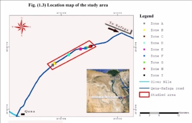 | Figure 1. Location map of the studied area |
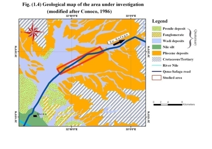 | Figure 2. Geological map of the studied area modified after Conoco (1986) |
 | Figure 3. A typical flexible pavement structure |
4. Materials and Methods
4.1. Materials
- 112 samples (40 disturbed samples and 72 undisturbed samples) represented eight different sedimentary microfacieses of Durri Formation and distributed along the road at the studied zones were collected. They were subjected to different geological and geotechnical investigations to achieve the scopes of the present work. The lithology and the thickness of the Pliocene sedimentary rocks (Durri Formation) at type locality (Gabel El-Durri, east of Higaza, South east of Qena) is a lacustrine white limestone and marly limestone, with shale, sandstone and conglomerates lenses and tongues. It comprises a pronounced one meter thick bed of fresh-water algal balls and oncolites (maximum 20cm in diameter). Globular weathering gives a false impression of the occurrence of stromatolites. Local syn-sedimentary slumping is observed. Thickness is 30m thinning out towards the Nile valley[19].
4.2. Methods
- Five geotechnical tests including specific gravity, Schmidt hammer, unconfined compressive strength (according to[20]), swelling pressure (using Oedometer test and accodding to[21] with seven stresses levels were applied including 0.25, 0.50, 1.00, 2.00, 4.00, 8.00 and 16.00kg/cm2) and slaking durability (according to[22]) were conducted on the studied sedimentary microfacieses of Durri Formation after two 10-minute cycles. Petrographical description of the studied sedimentary rocks using polarized light microscope with digital camera was conducted to understand a texture and a mineral composition of the studied sedimentarymicrofacieses. Chemical (x-ray fluorescence, XRF) and mineralogical (x-ray diffraction, XRD) analysis of the investigated sedimentary microfacieses were also carried out.
5. Results
5.1. Chemical and Mineralogical Analysis Results
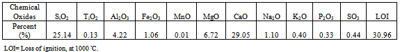
- Table (1) illustrated the chemical composition of the studied Durri Formation rock microfacieses distributed at the study area. The results showed that the studied Durri Formation was mainly composed of calcium, silica, magnesium and aluminum. It contained sodium, iron and others as minor components. Mineralogical analysis results showed that the Durri Formation at the study area was mainly composed of calcite, clay minerals (especially illite as major component and montmorillonite as minor component), quartz and dolomite.
5.2. Petrographical Study Results
- Petrographical studies were carried out on eight samples collected from Durri Formation according to the difference of facieses in the field and distributed at the study area (Figure 6). Eight thin sections were prepared and examined using polarized light microscope. The petrographical investigation showed that the investigated samples represent five main different microfaces of Durri Formation. These microfacies were mudstone, marlstone, marly limestone, dolomitic detrital limestone and detraital limestone. Figure (7) showed photomicrographs of the studied sedimentary microfacieses of Durri Formation illustrating their texture and their mineral composition. Petrographical description of these studied microfacieses were as follows:Mudstone microfacies was very fine to medium grained. It was recorded at the upper part of Durri Formation. The rock of this microfacies was green to greenish grey color. It consisted essentially of calcite, clay and quartz. The rock was composed of few skeletal debris, some reworked planktonic and benthonic foraminifera. These components were embedded in micrite matrix which partly stained by iron oxides. The microfacies was characterized by bioclastic packstone texture, see Figure (7.a).Marlstone microfacies was medium grained. It was recorded at the upper part of Durri Formation. The rock of this microfacies was greenish grey in color. It was cracked, ferruginous and containing shell fragments. The rock consisted essentially of calcite, clay and quartz. The rock contained approximately equal amount of calcite and clay minerals. The components were embedded in micritic matrix. This microfacies is bioclastic packstone texture, see Figure (7.e)Marly limestone microfacies was fine to medium grained. It was recorded at the upper part of Durri Formation. The rock of this microfacies was grey in color. It is hard, cracked, ferruginous and containing shell fragments. The rock consisted essentially of calcite, clay and quartz. Detraital calcite and other grains were embedded in micrite with partially sparite. This microfacies was lithoclastic/bioclastic and wackstone/packstone. Investigated specimen no.1 was fine and wackstone, specimen no.2 was medium and wackstone and specimen no.3 was very fine and wackstone, see Figures (7.b, 7.c and 7.d).Dolomitic detrital limestone microfacies was very fine grained. It was recorded at uppermost part of Durri Formation. The rock of this microfacies was yellowish grey in color. It was very hard, ferruginous and partially dolomitizied and silicified. The rock was essentially composed of calcite, clay, quartz and dolomite. Very fine calcite and quartz grains were embedded in micritic groundmass. This microfacies was characterized by wackstone texture, see Figure (7.f).Detraital limestone microfacies was fine to coarse grained. It was recorded at the uppermost part of Durri Formation. The rock of this microfacies was whitish to yellowish grey in color. It was ferruginous and consisted essentially of calcite and quartz. The rock was composed of fine to coarse detraital quartz grains. These components were embedded in micrit matrix with partially sparite. This microfacies was characterized by lithoclastic texture. An investigated specimen no.1 contained silt size detraital quartz grains and specimen no.2 contained sand size detraital quartz grains, see Figures (7.g and 7.h).
5.3. Geotechnical Results
5.3.1. Specific Gravity Test Results
- The results showed that the investigated samples of the rocks had slightly different values of specific gravity according to their mineral composition. Specific gravity values of the studied sedimentary rock microfacieses were ranging from 1.96 to 2.18g/cm3, see Table (2).
5.3.2. Schmidt Hammer Test Results
- Unconfined compressive strength was calculated using schmidt hammer number and specific gravity of each rock microfacies. Dolomitic detrital limestone, marlstone and marly limestone microfacies had higher values of Schmidt number and strength; in contrast, detraital limestone microfacieses had lower values. Unconfined compressive strength value, using schmidt hammer number, of the studied microfacieses were ranging from 274.00 to 461.07kg/cm2, see Table (2). Dolomitic detraital limestone microfacies had the highest value (461.07kg/cm2).
5.3.3. Unconfined Compressive Strength Test Results
- Unconfined compressive strength values (according to[20]) of the studied sedimentary microfacieses of Durri Formation were ranging from 155.32 to 291.92kg/cm2, see Table (2). Dolomitic detrital, marlstone and marly limestone had higher values (218.29 to 291.92kg/cm2) compared to detraital limestone and mudstone microfacieses which had lower values (155.92 to 197.50kg/cm2), see Table (2).
5.3.4. Swelling Pressure (Oedometer) Test Results
- Results of swelling pressure test using oedometer instrument (according to[21]) showed that the swelling pressure values of the studied microfacieses including mudstone, marlstone and marly limestone were ranging from 0.44 to 16.00kg/cm2. Marlstone microfacies had the highest value (16.00kg/cm2). In contrast, dolomitic and detrital limestone microfacieses had not swelling pressure, see Table (2).
5.3.5. Slake Durability Test Results
- Durability of rocks is fundamentally important for all applications. Changes in the properties of rocks are produced by slaking (decrepitating), exfoliation, hydration, solution, abrasion and other processes. Slake durability apparatus, after[22], was used to determine the durability of the studied sedimentary rocks. The results showed that the studied sedimentary rock microfacieses had retained percent ranging from 88.70 to 94.60%. They were described as medium to high durability after Gamble's classification. One sample (marlstone microfacies) had retained percent equal to 58.00% and was described as low durability, see Table (2).
|
|

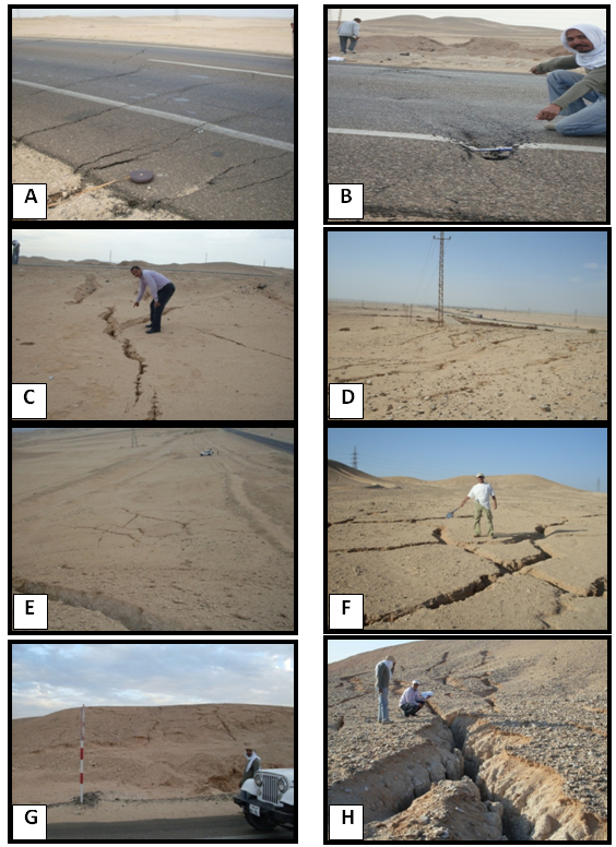 | Figure 4. Different forms of cracks including triple junction, polygon and randomly oriented cracks at the study area. A and B) Cracks across the asphalt layer at zone d. C) Triple junction cracks lie near the asphalt layer at zone d. D) Polygon and randomly oriented cracks at zone a. E) Polygon cracks at zone d. F) Polygon cracks at zone f. G) Polygon cracks on the top of Pliocene terraces at zone f. H) Large triple junction crack at zone d |
 | Figure 5. Damage of a water pipe at different studied zones. A and B) Damage of water pipe at zone d illustrated a heave of the old water pipe due to swelling of Pliocene sub-grade (mudstone, marlstone and marly limestone). C) Damage at zone f. D) Heave of the old water pipe due to swelling at zone e. E and F) Damages at zone i. G and H) Damages at zone h |
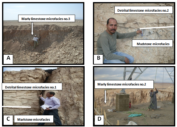 | Figure 6. Different sedimentary microfacieses of Durri Formation exposed at the studied area. A) Marly limestone microfacies no.3 exposed at zone d, B) Mudstone and detrital limestone microfacies no.2 at zone d, C) Detrital limestone microfacies no.1 and marlstone microfacies at zone d, D) Marly limestone microfacies no.2 at zone f |
 | Figure 7. Photomicrographs of the studied microfacieses (from a to h) |
6. Conclusions and Recommendations
6.1. Conclusions
- Analysis and interpretation of the laboratory results and the field observations led to the following findings:1- The chemical analysis of the studied Pliocene sedimentary microfacieses showed that the Durri Formation was mainly composed of calcium, silica, magnesium and aluminum. It contained sodium, iron and others as minor components. Mineralogical analysis results showed that the Durri Formation at the study area was mainly composed of calcite, clay minerals (especially illite as major component and montmorillonite as minor component), quartz and dolomite. 2- The petrographical investigation showed that the examined sedimentary rock specimens represent five main different microfaces of Durri Formation. These microfacies were mudstone, marlstone, marly limestone, dolomitic detrital limestone and detraital limestone. 3- The investigated rocks samples had slightly different specific gravity values according to their mineral composition. Specific gravity values of the studied sedimentary rock microfacieses were ranging from 1.96 to 2.18g/cm3. Dolomitic detrital limestone, marlstone and marly limestone microfacies had higher values of Schmidt number and strength; in contrast, detraital limestone microfacieses had lower values. Unconfined compressive strength value, using schmidt hammer number, of the studied microfacieses were ranging from 274.00 to 461.07kg/cm2. Dolomitic detraital limestone microfacies had the highest value (461.07kg/cm2). Unconfined compressive strength values (according to[20]) of the studied sedimentary microfacieses of Durri Formation were ranging from 155.32 to 291.92kg/cm2. Dolomitic detrital limestone, marlstone and marly limestone had higher values (218.29 to 291.92kg/cm2) compared to detraital limestone and mudstone microfacieses which had lower values (155.92 to 197.50kg/cm2). The swelling pressure values of the studied microfacieses including mudstone, marlstone and marly limestone microfacieses were ranging from 0.44 to 16,00kg/cm2. Marlstone and mudstone microfacieses had the highest values (16.00 and 6.50kg/cm2 respectively). In contrast, dolomitic and detrital limestone microfacieses had not swelling pressure. The different swelling pressure values of the studied microfacies due to the different percent and distribution of the clay minerals, where marlstone, marly limestone and mudstone microfacieses contained high percent of the clay minerals compared to dolomitic and detrital limestone microfacieses. The studied sedimentary rock microfacieses had retained percent ranging from 88.70 to 94.60%. These microfacieses were described as medium to high durability after Gamble's classification. One sample (marlstone microfacies) had retained percent equal to 58% and was described as low durability. Because this microfacies contained high percent of the clay minerals.4- The expansive sedimentary rock microfacieses of Durri Formation including mudstone, marlstone and marly limestone microfacieses which represent the sub-grade of the road had been swollen (with swelling pressure values equal to 6.50 and 16.00kg/cm2) due to water coming from the damaged old water pipe which runs parallel to the road and that led to a heave of the road and the old water pipe. The heave of the old water pipe led to an increase of the damage and the amount of water coming from this pipe (Figure. 4 and 5). Consequently, that caused an increase of the swelling pressure and the heave which led to triple junction cracks. In addition, drying the saturated Pliocene sedimentary microfacieses (after reformation the individual damage at each zone) due to solar radiation led to a formation of large scale mud cracks having polygonal and randomly oriented forms. These cracks occurred on the asphalt layer and in the area around the road at the study area. The occurrence and the distribution of these cracks were depending on the distribution of the Pliocene sedimentary rocks, on the concentration and the distribution of the clay minerals (Illite and montmorillonite) of the studied Pliocene microfacieses, on the location of the water pipe damage and on the amount of the water coming from this damaged water pipe. The high temperature which characterized the arid region (Egyptian eastern desert) might be modified the illite mineral and increased its activity.
6.2. Recommendations
- After an interpretation and an evaluation of the problem, the following points were recommended: 1- Constructing a new water pipe instead of the damaged old water pipe using flexible joints in order to support the possible new movements caused by the expansion.2- Grouting and filling the cracks using cement.3- Replacement of the expansive Pliocene sedimentary rock sub-grade using well graded sand and gravels and/or chemical stabilization of this sub-grade using lime to reduce the swelling pressure. 4-Monitoring system of the studied cracks using total station to evaluate the displacements of these cracks and to determine the relationship between cracks origin and recent tectonic movements at the studied area. An effective approach is to model the ground by using well-chosen discrete points located on the surface of the ground which, when situated correctly, accurately depict the characteristics of the ground. That means any movements of those points represent deformations of the object[23]. One of the most important aspects of any geodetic deformation monitoring network is the quality of monumentation. The survey monuments can be installed at the stable edges of the cracks and the cracks center lines. A monument can be contained of a pin made of steel; it can be 1.5cm in diameter and 10cm in height. It can be centered in a concrete base with 30×30cm. The survey targets can be centered on a steel pin.5-Shallow seismic method was suggested to determine the real depth of these cracks.
AKNOWLEDGEMENTS
- Greatly thanks to staff members of Qena faculty of engineering, in both South Valley University and Al-Azhar University, for offering the laboratories facility to conduct the geotechnical tests of this research.