B. M. R. Faisal1, M. A. Haydar2, M. I. Ali2, D. Paul2, R. K. Majumder3, M. J. Uddin1
1Department of Environmental Sciences, Jahangirnagar University, Dhaka-1342, Bangladesh
2Health Physics and Radioactive Waste Management Unit (HPRWMU), Institute of Nuclear Science and Technology (INST), Atomic Energy Research Establishment (AERE), Bangladesh Atomic Energy Commission (BAEC), Savar, Dhaka-1349, Bangladesh
3Nuclear Minerals Unit, Atomic Energy Research Establishment (AERE), Bangladesh Atomic Energy Commission (BAEC), Savar, Dhaka-1349, Bangladesh
Correspondence to: B. M. R. Faisal, Department of Environmental Sciences, Jahangirnagar University, Dhaka-1342, Bangladesh.
| Email: |  |
Copyright © 2014 Scientific & Academic Publishing. All Rights Reserved.
Abstract
The radioactivity levels of naturally occurring radionuclides 226Ra, 232Th and 40K in thirteen topsoil samples, collected from Savar industrial area of Bangladesh, were measured by gamma ray spectrometry system using a High Purity Germanium (HPGe) detector of 40% relative efficiency. The calculated average activity concentrations of 226Ra, 232Th and 40K in the collected samples were 23.31 Bq.kg-1, 42.24 Bq.kg-1 and 733.19 Bq.kg-1, respectively. The average activity concentration of 232Th and 226Ra in the present study is lower than that of the world-wide average value but the concentration for 40K is much higher than the world average of 420 Bq.kg-1. The estimated average absorbed dose rate (D), the outdoor annual effective dose (E) and the external hazard index (Hex) were found as 67.08 nGyh-1, 0.08 mSvy-1 and 0.38 Bq.Kg-1, respectively. The absorbed dose rate and outdoor annual effective dose are slightly higher than the world average value but the external hazard index is lower than that of the recommended value. The results of present study show that the soil of the study area is safe from radiological hazards and will not pose any harmful effect to the environment. The outcome of this study may provide valuable information about radiation hazard as well as may be useful as the baseline data in the monitoring of environmental radioactivity in the industrial zone under study.
Keywords:
Natural Radioactivity, High-Purity Germanium (HPGe) Detector, Activity Concentrations, Absorbed Dose Rate, Annual Effective Dose Rate, External Hazard Index
Cite this paper: B. M. R. Faisal, M. A. Haydar, M. I. Ali, D. Paul, R. K. Majumder, M. J. Uddin, Assessment of Natural Radioactivity and Associated Radiation Hazards in Topsoil of Savar Industrial Area, Dhaka, Bangladesh, Journal of Nuclear and Particle Physics, Vol. 4 No. 4, 2014, pp. 129-136. doi: 10.5923/j.jnpp.20140404.03.
1. Introduction
Natural radioactivity is widespread in the earth environment and it exists in various geological formations such as earth crust, rocks, soils, plants, water and air [1]. In addition to natural sources, soil radioactivity is also affected by anthropogenic activities. Numerous types of human activities and non-nuclear industries contribute to further concentrate some of the natural radionuclides that can be found in the earth’s crust affecting the human and the environment. The main contributors of radionuclides are 40K and 232Th and these radionuclides are not uniformly distributed in soils and vary from region to region [2]. Soil provides a direct source of radioactivity in food chain due to its uptake by agricultural plants. The radioactivity caused by radionuclides can transfer from soil, water and air to plants, trees and other biological elements and finally to human body which may deposited in this three media either by mining or any other natural or man-made activities. Gamma radiation emitted from primordial radionuclide and their progeny is one of the main external sources of radiation exposure to the humans [3]. Terrestrial radioactivity and the associated external exposure due to gamma radiation, depends primarily on the geological formation and soil type of the location; and these factors (geology and soil type) greatly influence the dose distribution from natural terrestrial radiation [1]. Majority of the external gamma dose rate above typical soils (95%) arises from primordial radionuclides incorporated in the soil [4]. The major potential hazard from the natural radiation is from external exposure either by direct exposure to soil or as they enter in many building materials.Since natural radiation is the largest contributor of external dose to the world population, assessment of gamma radiation dose from natural sources is of particular importance. The radioactivity concentration of radionuclides above permissible level is very harmful for human health. Moreover, contamination may happen in the surrounding environmental elements such as soil due to the leaching of radionuclides from industrial activity. Industries cause environmental degradation thought the life cycle of a product starting from exploration of raw materials and energy resources to disposal of waste and end products [5]. The industrial units in Savar industrial area include garments, textile, knitting, leather goods, metal products, electronic goods, paper products, chemicals and fertilizers and miscellaneous products [6]. Industrial activities discharge untreated or poorly treated industrial wastewater, effluent and even sludge into the surrounding environment which may contain elevated level of radioactivity. Besides, the uneducated farmers in that area are randomly using fertilizers and pesticides in agricultural lands. Since, there is no data available on the radioactivity contents in the soil and radiological impact of the probable contents on people and environment in Savar industrial area. Therefore, the aim of the present study is to assess the probable natural terrestrial radionuclide contents and corresponding health risk due to exposure to these radionuclides present in the topsoil of Savar industrial area.
2. Materials and Methods
2.1. Study Area
The study area lies between 2354′47.8″ to 2348′33.1″ north latitude and 9014′52.6″ to 9014′44.5″east longitude (Figure 1). The industries along both sides of Dhaka-Aricha highway from Hemayetpur to Savar bus stand are in industrial cluster-6, ‘Dhaka Export Processsing Zone Depz’ (DEPZ) and DEPZ (extended), Ashulia and Jirabo industrial area are in cluster-8. The study area comprises of many isolated water bodies occupying the low lying and depressed areas connected to or out-of-the-way from the river system. The Bansi-Daleshwari and Turag river system comprise the drainage network of the study area–where the Bansi flows on the west and the Turag is away on the east. The land of Savar industrial area composed of Pleistocene red clay and recent alluvium soil. The major part of the land is used for the cultivation of agricultural products and the rest is used for industrial activity.
2.2. Sampling Locations
Soil samples were collected from different locations of the study area adjacent to Hemayetpur, Savar, Ashulia, Bipyle, Mirjanagar and Nayerhat by traverse method. This area receives the drainage residue of the industrial area and other adjoining residential and numerous classified/unclassified industrial wastes. The geographical location of each sampling points were determined with a handheld global positioning system (GARMIN). A total number of thirteen topsoil samples were collected in May, 2013 (Figure 1).
2.3. Processing of Soil Samples
After collection, packaging and marking all the samples were transported to and preserved at the sample processing laboratory of the Health Physics and Radioactive Waste Management Unit, Bangladesh Atomic Energy Commission (BAEC), Savar, Dhaka. Each sample was then cleaned and dried in the sun separately and crushed into fine powder by using a grinder. The samples were then mixed homogeneously and passed through a sieve of 200 μm mesh size. The homogenized soil samples were then dried in a temperature controlled oven at 110℃ for about 24 hours. The samples were then transferred to sealable cylindrical plastic containers of 7 cm and 5.5 cm in diameter and the weights of the samples were recorded using an electrical balance. The sample-filled containers were marked individually with identification parameters e.g., sample ID, date of preparation and net weight. The containers were sealed tightly with insulating tape around their opening for impeding the possibility of moisture contamination. In order to maintain radioactive secular equilibrium between 226Ra and its daughter products, the sealed containers were stored for a period of 4 weeks [7].
2.4. Experimental Set-Up
The detection and measurement of radionuclides in the samples were carried out by gamma ray spectrometry system using a vertical co-axial cylindrical High Purity Germanium (HPGe) detector of 172 cm3 active volume and with 40% relative efficiency. The p-type HPGe detector supplied by CANBERRA (Model- GC 4020) had a resolution of 2 keV at 1332 keV of Cobalt-60 gamma-ray line. The detector was coupled to a 16 k-channel analyzer. The spectra of all samples were perfectly analyzed using Genie-2000 spectra analysis software (which matched various gamma energy peaks to a library of all possible radionuclides) to calculate the concentrations of 226Ra, 232Th and 40K. The detector was enclosed in a cylindrical shielding container made of Lead and Iron with 11.3 cm thickness, 51 cm height and 28 cm internal diameter and having a fixed bottom and moving cover to reduce the external gamma-ray background. All the samples were counted for 10 ks. Prior to the measurement of the samples, the environmental gamma background at the laboratory site was determined with identical plastic container used in the sample measurement. The energy regions selected for the corresponding radionuclides were 295 keV and 352 keV of 214Pb and 609 keV, 1120 keV and 1764 keV for 214Bi for 226Ra, 583 keV and 2614 keV of 208Tl, 911 keV and 969 keV of 228Ac for 232Th and 1460 keV for 40K [8].
2.5. Calibration of the Detector
The efficiency calibration of the detector was performed by standard sources of solid matrices prepared using 226Ra standard using identical containers used for the measurement of the samples, e.g., 180 ml plastic container for solid samples. The preparation process of standard sources had been reported elsewhere [9]. The detector efficiency calibration curves as a function of energy for solid matrices are shown in Figure 2. The energy calibration of the detector was performed by 137Cs and 60Co point sources.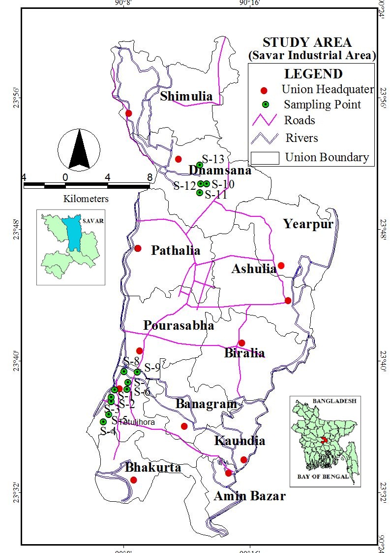 | Figure 1. Location map of Savar industrial area, Bangladesh |
 | Figure 2. Efficiency curve of 40% relative efficiency for the solid matrix |
2.6. Activity Concentrations of Soil
The radionuclide contents and their activity levels in the samples were measured using a calibrated HPGe detector. The activity concentration (A) of each radionuclide in the samples was determined by using the net count (cps) (found by subtracting the background counts from the gross counts with same counting time under the selected photo peaks), weight of the sample, the photo-peak efficiency and the gamma intensity at a specific energy as [10]. | (1) |
Where, A = Activity concentrations of the sample in Bq.kg-1, CPS = the net counts per second = cps for the sample- cps for the background value, E = the counting efficiency of the gamma energy, I = Absolute intensity of the gamma ray and W = Net weight of the sample (in kilogram). The errors in the measurement were expressed in terms of standard deviation (±2σ), where σ is expressed as [1]. | (2) |
Where, Ns is the sample counts measured in time Ts, and Nb is the background counts measured in time Tb. The standard deviation ±2σ in cps was converted into activity in Bq.kg-1 according to equation (1).
2.7. Absorbed Dose Rates
The external outdoor absorbed gamma dose rates due to terrestrial gamma rays from the nuclides 226Ra, 232Th and 40K at 1m above the ground level were calculated as follows outlined by [11]. | (3) |
Where, D is the dose rate in nGyh-1 and CRa, CTh and CK are the specific activities (Bq.Kg-1) of 226Ra, 232Th and 40K, respectively.
2.8. Outdoor Annual Effective Dose
The absorbed dose rate was converted into annual effective dose equivalent by using a conversion factor of 0.7 SvGy-1 [1] and 0.2 for the outdoor occupancy factor by considering that the people on the average spent 20% of their time in outdoors [12]. The effective dose due to natural activity in the soil samples was calculated by [11].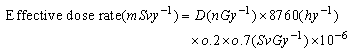 | (4) |
Where, D = the absorbed dose rate in air (nGyh–1); 8760 = the time in hours for one year; 0.2 = the outdoor occupancy factor; 0.7 = SvGy-1 is the quotient of effective dose equivalent rate to absorbed dose rate in air and 10-6 = the factor converting nano into milli.
2.9. External Hazard Index (Hex)
Local soil of the area is used for the construction of houses and also for agricultural purposes. These soils may contribute to the external gamma dose rates to the public. The external hazard index (Hex) is the indoor radiation dose rate due to the external exposure to gamma radiation in construction materials of dwelling which is calculated by [13].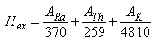 | (5) |
Where, ARa, ATh and AK are the activity concentration in Bq.Kg-1 of 226Ra, 232Th and 40K respectively. The value of Hex must be lower than unity in order to keep the radiation hazard insignificant.
3. Results and Discussions
3.1. Activity Concentration in Topsoil Samples
The results of activity concentrations of radionuclides obtained from gamma spectrometry technique for 13 topsoil samples collected from Savar industrial area are presented in Table 1, with the uncertainty level of ±2σ. The results for the radionuclides 226Ra, 232Th and 40K are also shown graphically in Figure 2, Figure 3 and Figure 4, respectively.| Table 1. Activity concentration of 226Ra, 232Th and 40K in topsoil sample |
| | Sample ID | Activity concentration (Bq.Kg-1) | | 226Ra | 232Th | 40 K | | S-01 | 31.28 ± 6.50 | 46.44 ± 13.13 | 848.67 ± 171.60 | | S-02 | 6.31 ± 7.79 | 47.78 ± 13.03 | 894.64 ± 170.92 | | S-03 | 18.63 ± 6.35 | 41.11 ± 12.98 | 945.21 ± 171.66 | | S-04 | 14.47 ± 6.66 | 32.76 ± 10.51 | 439.84 ± 169.67 | | S-05 | 14.98 ± 6.39 | 20.38 ± 12.86 | 591.24 ± 171.35 | | S-06 | 32.05 ± 6.42 | 46.20 ± 12.94 | 1064.82 ± 171.17 | | S-07 | 34.56 ± 7.02 | 41.17 ± 10.61 | 798.89 ± 172.16 | | S-08 | 14.98 ± 6.28 | 23.37 ± 12.70 | 666.81 ± 169.10 | | S-09 | 34.78 ± 6.57 | 54.54 ± 10.73 | 826.57 ± 171.91 | | S-10 | 7.58 ± 6.27 | 27.02 ± 12.91 | 556.53 ± 170.48 | | S-11 | 21.30 ± 8.14 | 32.90 ± 8.14 | 666.81 ± 174.06 | | S-12 | 47.78 ± 7.07 | 67.57 ± 10.75 | 723.49 ± 170.48 | | S-13 | 24.34 ± 6.57 | 67.95 ± 11.18 | 507.96 ± 171.23 | | Maximum | 47.78 ± 8.14 | 67.95 ± 13.13 | 1064.82 ± 174.06 | | Minimum | 6.31 ± 6.27 | 20.38 ± 8.14 | 439.84 ± 169.10 | | Average | 23.31 ± 6.77 | 42.24 ± 11.73 | 733.19 ± 171.22 | | World Average | 33 | 45 | 420 |
|
|
3.1.1. Activity Concentration of 226Ra
The concentration of 226Ra ranges from 6.31 ± 6.27 Bq.Kg-1 to 47.78 ± 8.14 Bq.Kg-1 with an average of 23.31 ± 6.77 Bq.Kg-1. The highest value for 226Ra (47.78 ± 8.14) was found in S-12, near the Berger paints industry, Ashulia and lowest value (6.31 ± 6.27) was found in S-09, beside the Dhelasware river bank, Hemayetpur (Figure 2). The average radioactivity level for 226Ra (23.31 Bq.Kg-1) is less than the worldwide average value of 33 Bq.Kg-1 [1].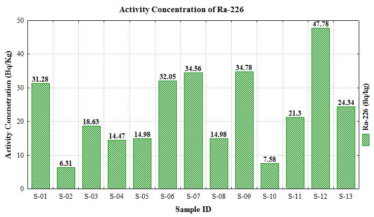 | Figure 2. Distribution of 226Ra in topsoil samples |
3.1.2. Activity Concentration of 232Th
The 232Th radioactivity concentration varies from 20.38 ± 8.14 to 67.95 ± 13.13 with an average of 42.24 ± 11.73 Bq.kg-1. The highest 232Th activity of 67.95 ± 13.13 Bq.kg-1 was found in the S-13 near the Berger paints industry, Ashulia while the lowest 232Th activity concentration of 20.38 ± 8.14 Bq.kg-1 was found in S-05 Karnapara, Savar (Figure 3). The average radioactivity level of 232Th (42.24 Bq.kg-1) is also lower than the worldwide average value of 45 Bq.kg-1 [1].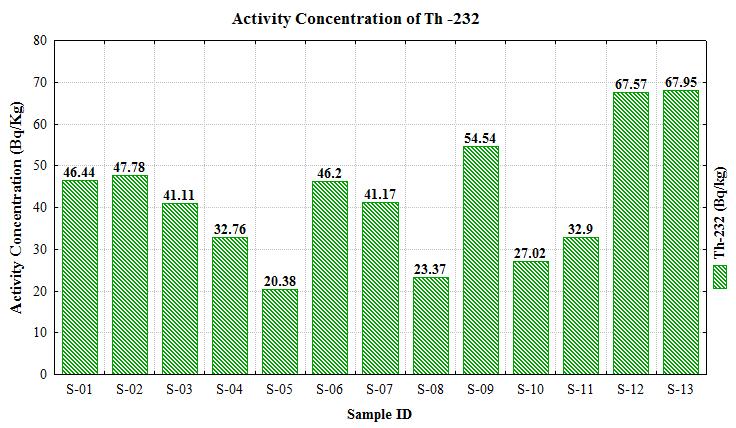 | Figure 3. Distribution of 232Th in topsoil samples |
3.1.3. Activity Concentration of 40K
The activity concentrations of 40K ranges from 439.84 ± 169.10 to 1064.82 ± 174.06 Bqkg-1 with an average value of 733.19 ± 171.22 Bqkg-1. The highest 40K concentration of 1064.82 ± 174.06 Bqkg-1 was found in S-04 beside the Anlima dying industry and the lowest value of 439.84 ± 169.10 Bqkg-1 was found in S-04 karnapara, Savar (Figure 4). The average value of 40K 733.19 Bqkg-1 is significantly higher than that of the worldwide average value of 420 Bqkg-1 [1]. This result strongly suggests that radioactivity level for 40K may arise from Madhupur clay formation as well as agricultural activity which requires potassium enrich fertilizers and pesticides and various industrial inputs in this area. 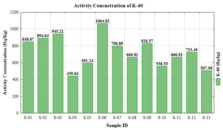 | Figure 4. Distribution of 40K in topsoil samples |
The results of the current study reveal that the activity concentration of 226Ra is lower than the world average level whereas the activity concentration of 232Th is much closer the world average value. On the other hand, the activity concentration of 40K in soil samples is much higher than the world average concentration.
3.2. Radiological Hazard Assessment
Different known radiation health hazard indices have been used in radiation studies to arrive at a better and safer conclusion on the health status of an exposed person and environment now a day. In order to assess the health effects, the ‘Absorbed Dose Rate’ (D), ‘Outdoor Annual Effective Dose’ (E) and ‘External Hazard Index’ (Hex) have been calculated from the activity concentrations of 226Ra, 232Th and 40K using equations (3), (4) and (5), respectively and the values are shown in Table 2.| Table 2. Absorbed Dose Rate (D), Outdoor Annual Effective Dose (E) and External Hazard Index (Hex) of all topsoil samples |
| | Sample ID | Absorbed Dose Rate, D (nGyh-1) | Outdoors Annual Effective Dose, E (mSvyr-1) | Hex(Bq.Kg-1) | | S-01 | 78.15 | 0.10 | 0.44 | | S-02 | 69.35 | 0.09 | 0.39 | | S-03 | 73.14 | 0.09 | 0.41 | | S-04 | 44.94 | 0.06 | 0.26 | | S-05 | 44.06 | 0.05 | 0.24 | | S-06 | 87.43 | 0.11 | 0.49 | | S-07 | 74.38 | 0.09 | 0.42 | | S-08 | 49.04 | 0.06 | 0.27 | | S-09 | 83.72 | 0.10 | 0.48 | | S-10 | 43.20 | 0.05 | 0.24 | | S-11 | 57.72 | 0.07 | 0.32 | | S-12 | 93.27 | 0.11 | 0.54 | | S-13 | 73.62 | 0.09 | 0.43 | | Maximum | 93.27 | 0.11 | 0.54 | | Minimum | 43.20 | 0.05 | 0.24 | | Average | 67.08 | 0.08 | 0.38 | | World Average | 59 | 0.07 | 1.00 |
|
|
The results shown in Table 2 depict that the absorbed dose rates due to the terrestrial gamma rays at 1m above from the ground are in the range of 43.20 to 93.27 nGyh-1 with an average of 67.08 nGyh-1 for topsoil samples in the area under study. This value is slightly higher than the world average value of 59 nGyh-1 [1]. The outdoor annual effective doses are in the range of 0.05 to 0.11 mSvyr-1 with an average of 0.08 mSvyr-1 in topsoil samples; which is comparable with the world average value of 0.07 mSvyr-1 [1]. On the other hand, the external radiation hazard index ranges from 0.24 to 0.54 Bq.Kg-1 with an average value of 0.38 Bq.Kg-1, which is far less than the unity indicating the non-hazardous category of the samples. Therefore, it can be concluded that the radiation hazard due to the radiation exposure to the soils under investigation is insignificant. The values of hazard indices confirm that the study area is safe to carry out industrial and agricultural activities for the workers and general public and moreover, no significant radiological impacts have been observed on the surrounding environment.
4. Conclusions
The radionuclide contents, activity concentrations and radiological impact of the topsoil samples collected from the Savar industrial area of Bangladesh were investigated in the present study. The natural radioactivity concentrations of 226Ra and 232Th were slightly lower than that of the world average values for topsoil samples. But the radioactivity concentration of 40K was significantly higher than the world average value. However, slight variation in the radioactivity content in soil observed with different locations mainly due to soil type, formation and transport process involved in the study area. The values of average absorbed dose rate and outdoor annual effective dose were slightly higher than the world average values; whereas the external hazard indices were found less than unity which indicates that there is no probability of immediate health effect on workers and public due to natural radioactivity present in the samples of the study area. Therefore, the area under present study may be termed as radiolologically safe. Nevertheless, elevated level of health risk may be caused due to natural terrestrial radiation from these soils on the inhabitants of this area if the uncontrolled industrial process and agricultural activities continue.
ACKNOWLEDGEMENTS
The author would like to acknowledge the Ministry of Science and Technology, The Peoples’ Republic of Bangladesh for the NST fellowship to carry out the research. The authors also like to thank the technical support staffs of Health Physics and Radioactive Waste Management Unit (HPRWMU), INST, Atomic Energy Research Establishment, Savar, Dhaka and Department of Environmental Sciences, Jahangirnagar University, Savar, Dhaka-1342 for their help in conducting the study.
References
| [1] | UNSCEAR, (United Nations Scientific Committee on the Effects of Atomic Radiation Sources) Effects and risks of ionizing radiation, (2000). |
| [2] | Miah, F. K., Roy, S., Touhiduzzaman, M. & Alam, B. Distribution of radionuclides in soil samples in and around Dhaka city. Applied Radiation and Isotopes, 49 (1, 2), pp. 133-137 (1998). |
| [3] | UNSCEAR, (United Nations Scientific Committee on the Effects of Atomic Radiation) Sources, Effects, and Risks of Ionizing Radiation, (1993). |
| [4] | Jabbar, A., Tufail, M., Arshed, W., Bhatti, A. S., Ahmad,S. S., Akhter, P. and Dilband, M. Transfer of radioactivity from soil to vegetation in Rechna Doab, Pakistan. Isotopes in Environmental and Health Studies, 46, pp. 495 (2010). |
| [5] | Suzuki, K.T.H., Sunaga, A.Y., Hatakeyama, Y., Sumi and Suzuki. Binding of cadmium and copper in the mayfly baetis thermicus larvae. Comp. Biochem. Physical, 91c:487-492 (1998). |
| [6] | Khan, M.K., Alam, A.M., Islam, M.S., Hassan, M.Q., Al Mansur, M.A. Environmental pollution around Dhaka EPZ and its impact on surface and groundwater, Bangladesh. Journal Sci. Ind. Res. 46, pp. 153–162 (2011). |
| [7] | Hasan, M. M., Ali, M. I., Paul, D., Haydar, M. A. and Islam, S. M. A. Measurement of Natural Radioactivity in Coal, Soil and Water Samples Collected from Barapukuria Coal Mine in Dinajpur District of Bangladesh. Journal of Nuclear and Particle Physics, 3(4): 63-71 (2013). |
| [8] | Roessier, C. E., Smith, Z. A., Bloch, W.E. and Prince, R.J. Uranium and radium in Floride phosphate materials, Health Physics. vol. 37, pp. 269-277 (1970). |
| [9] | Usif, M. A. and Taher, A. E. Radiological assessment of Abu-Tartur phosphate, western desert Egypt, Radiation Protection Dosimetry, vol.130, pp. 228-235 (2008). |
| [10] | Knoll, G. F. Radiation detection and measurement. 2nd edition, John Wiley and Sons, Inc.pp.388-89 (1989). |
| [11] | Kessaratikoon, P. and Awaekechi, S. Natural radioactivity measurement in soil samples collected from municipal area of Hat Yai District in Songkhla Province, King Mongkut’s Institute of Technology Ladkrabang Science Journal, Vol. 8, No. 2, , pp. 52-58 (2008). |
| [12] | Debertin, K., and Helmer, R.G. Gamma and X-ray spectrometry with semiconductor detectors. Elsevier Science, Amsterdam (1988). |
| [13] | Lu, X. and Xiolan, Z. Measurement of natural radioactivity in sand. |
 Abstract
 Reference
 Full-Text PDF
 Full-text HTML