-
Paper Information
- Paper Submission
-
Journal Information
- About This Journal
- Editorial Board
- Current Issue
- Archive
- Author Guidelines
- Contact Us
Journal of Civil Engineering Research
p-ISSN: 2163-2316 e-ISSN: 2163-2340
2019; 9(2): 51-57
doi:10.5923/j.jce.20190902.02

Landslide Causes and Corrective Measures – Case Study of the Sarajevo Canton
 Abstract
 Reference
 Full-Text PDF
 Full-text HTML
1Faculty of Civil Engineering, University of Sarajevo, Sarajevo, BiH
2Development Planning Institute of the Sarajevo Canton, Sarajevo, BiH
Correspondence to: Amra Serdarevic, Faculty of Civil Engineering, University of Sarajevo, Sarajevo, BiH.
| Email: |  |
Copyright © 2019 The Author(s). Published by Scientific & Academic Publishing.
This work is licensed under the Creative Commons Attribution International License (CC BY).
http://creativecommons.org/licenses/by/4.0/

The term landslide is well known to the general public and it is associated mainly with negative news of material and human casualties. This is why they are often mentioned in the media when they are already happened. Landslides are defined as the movement of soil or rock masses down the slope. It includes all forms of movement from landsliding, rolling of stones, falling rocks, rotational and translational sliding to the flow of different materials. Movements take place mainly on curved sliding surfaces. Moving of the mass on or along the slope (sliding) can be slow and barely noticeable in time, but it can also be very fast and destructive. The causes of landslides occurrence may be different, but in general, a landslide occurs when the active forces (mainly gravity) exceed the strength of soil materials and rocks that form the slope. Causes include factors that increase the effects of traction forces and factors that contribute to the weak or reduced strength of the slope material. Recently, mostly caused by extreme precipitation in a relatively short time, the numerous landslides in BiH have been activated. This paper presents the status and realization of landslide rehabilitation projects in Sarajevo Canton (SC).
Keywords: Landslides, Corrective measures, Mitigation, Monitoring
Cite this paper: Amra Serdarevic, Fuad Babic, Landslide Causes and Corrective Measures – Case Study of the Sarajevo Canton, Journal of Civil Engineering Research, Vol. 9 No. 2, 2019, pp. 51-57. doi: 10.5923/j.jce.20190902.02.
Article Outline
1. Introduction
- Landslides are defined as the movement of a different type of soil, rock or debris. Those movements happen down or along a slope. Slope movements could be caused by multiple factors like rainfall, snow melting, changes in groundwater level, soil erosion, earthquakes or by human activities. Inhabitants or homeowners occupy unstable areas, especially in low income countries or in development countries, usually because they don’t have any other places to relocate. Negative effects of landslides are often reflected to local community, but consequences and high costs for implementation of the intervention measures frequently become the state problems. Before any activities, if possible, it is recommended to consult engineers, geologists and other experts, experienced in the successful realization of stabilization or risk mitigation of unstable slopes. The occurrences and first records of landslides in the Sarajevo Canton (SC) were recorded during Austro-Hungarian rule as a consequences of some natural phenomena. More intense processing and landslides records start at the beginning of the 1970s.The increased number of landslides in the city of Sarajevo dates from the end of the Second World War, more precisely, from the first cases of illegal construction of residential buildings in Sarajevo. The real explosion of the landslide events in the Sarajevo Canton took place after the end of the war in BiH in 1995. This paper presents an overview of landslide occurrence, situation with landslides in the Sarajevo Canton including few examples of landslide stabilization measures.
2. Overview of Landslide Characteristics
- Generally, landslide is a term used to describe movement of rock, soil or debris usually by gravity down a slope or it is a term for typical landform with characteristic surface marks (Fig.1).
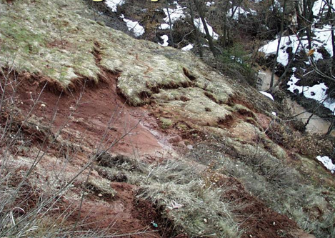 | Figure 1. An example of one of type of landform typical for unstable terrain [1] |
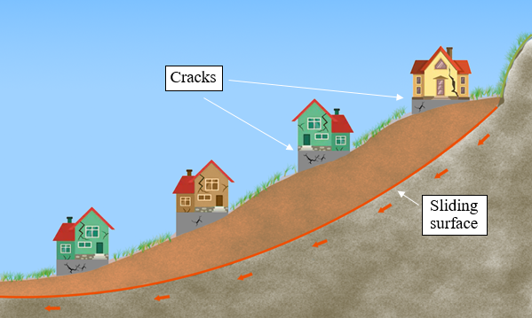 | Figure 2. Schematic of a global unstable area |
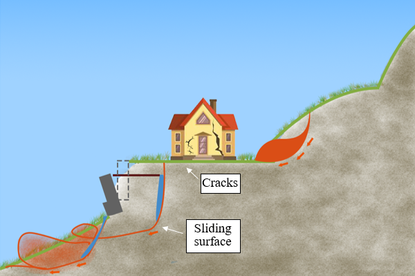 | Figure 3. Schematic of local instability of terrain due to the illegal structure |
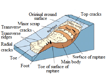 | Figure 4. Illustration of the common terms for rotational landslide that has evolved into an earthflow [2] |
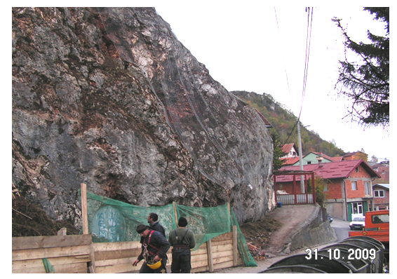 | Figure 5. A rockfall/slide that occurred in Porodice Foht street in the Sarajevo Canton (2009.). with example of a rock curtain, a barrier commonly applied over hazardous rock face [1] |
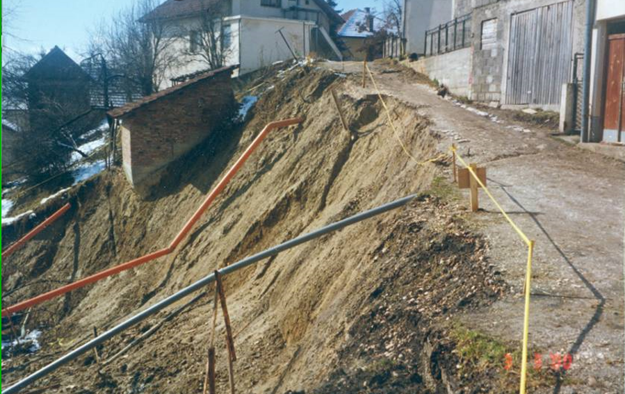 | Figure 6. Consequences of landslide in the Sarajevo Canton (Kromolj), caused by rainfall, and possibly made worse by sewage leakage [5] |
3. Landslides in the Sarajevo Canton
- The landslides in the Sarajevo Canton area are mentioned in the city notes, from its early beginnings of planned construction under Austria-Hungarian rule. However, the number of landslides has increased significantly since 1995, caused by the war consequences in BiH, when the reconstruction of cities and infrastructure has begun. In this period, there was the attempt to implement mitigation measures for landslides according to the priorities and conditioned by the situation on the ground.By establishing the records on landslides, the problems that caused landslides were noticed. By analyzing the appearance of the landslide since 2000, the causes, characteristics and measures for mitigating the damage have been systematized.The main causes for landslides in the Sarajevo Canton from 1995 to 2019 are:• Illegal construction of private housing facilities throughout the Sarajevo Canton.• Terrain instability as a result of warfare and detonation of explosive devices during the 1992-1995 operations. • Massive, uncontrolled felling of forests and parks vegetation during the war in Sarajevo.• Leakage from the water supply network (> 70% of losses is identified in the Sarajevo water network)• Poor condition in drainage system of precipitation and fecal wastewater• Damage on drinking water reservoirs located on the outskirts of the city of Sarajevo.Several landslides have been recorded at the Sarajevo Canton, which are the result of natural phenomena. The landslides are located outside the populated areas of the city and there is no illegal construction on them. This type of landslide is mostly inactive, registered in the database and included in the geodetic monitoring network.
3.1. Reasons for Landslides in the Sarajevo Canton
- The most important cause of the landslide occurrence in the Sarajevo Canton has been the expansion of the illegal construction of residential buildings. The problem of illegal construction has been present for over 50 years. The increase in illegally built facilities in SC is also a consequence of the migration of the population to larger cities after the war in BiH (1992-1995). Since 1995, there have been a triple increase in the number of illegal individual housing units in some locations.How does a landslide appear due to illegal construction? Uncontrolled construction affects the appearance of landslides in different ways and the landslide phenomenon is associated with:• Construction of residential buildings on terrains that can not withstand heavy loads.• Construction of residential and other facilities without quality geological explorations.• Building objects without adequate project documentation.• Lack of quality infrastructure.• Impact of leaks from illegal connections to water-supply and sewerage.• Construction of facilities for domestic animals and discharges of wastewater down the slope or near residential buildings.• Inadequate drainage of rain water.• Construction of inadequate septic tanks and wastewater discharges along the slope in the immediate vicinity of residential buildings.• Poor construction of pavement constructions, especially in the slopes of the city, where there is no rainwater drainage• Inappropriate cross-sectional and longitudinal slopes of road structures that cause the discharge of surface waters along the surrounding slopes.All of these causes can be associated with the appearance of a landslide as a single, but may also occur in combination. However, which measures have been applied to prevent the landslide from being illegally constructed?There is a very rare occurrence of the demolition of illegally constructed residential buildings. The "legalization" of residential buildings is mainly carried out, along with recording of potential landslides and implementation of mitigation and rehabilitation measures on the ground. Very often measures are related to the installation of the surface drainage channel, which leads to the stabilization of the terrain (Fig.7).
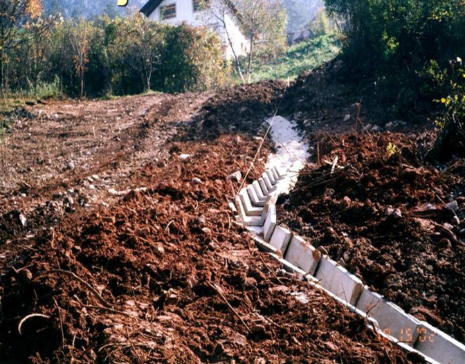 | Figure 7. Illustration of the mitigation measure with open channel for surface water drainage in the Sarajevo Canton (Brusulje) [1] |
3.2. Land Register – Database
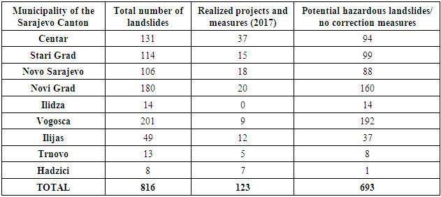
- In the period from 1996 to 2000, the total of 745 landslides were registered in the Sarajevo Canton, of which 234 landslides were active.From this initial step, the database management and updating were established. The number of active and inactive or stabilized landslides at the municipalities of the Sarajevo Canton, for 2017, is shown in Table 1.
|
3.3. Landslides Survey
- The landslides survey is one of the most important stages in dealing with landslides. This activity is an input of what and how we should treat the landslides.Many examples from our practice have shown that mitigation measures can be ineffective and unprofitable if they are designed and operated without sufficient knowledge about the landslides. It is a mistake to conclude that remediation and approach to landslide problems can be solved with a template application of even with the most expensive mitigation measures.Based on experience it can be concluded that if landslide studies were missing or they are insufficient, then the mitigation measures were mostly: wrong, insufficient, oversized and unreasonable.The figures 8a and 8b show the landslide rehabilitation and the state after the rehabilitation of Stolacka street. The situation is complex since the street is pretty long and located in the central part of Sarajevo, above the sports center “Skenderija”. Following identification of the five landslides, it was developed a restoration plan. In order to repair the major landslide, 8 anchors were installed, and a reinforced concrete retaining wall with counterforts was constructed. The total length of the supporting structure was 110 m and the average excavation depth was 5 m. The landslide remediation measures included also the drainage of surface water and reconstruction of the sewerage system. The total investment value of the described landslide remediation works was 250,000.00 EUR. The works were conducted within period of five months.
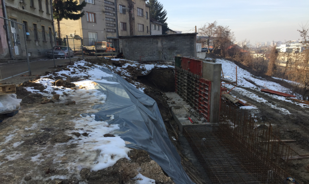 | Figure 8a. Lateral spreading damage - Stolacka street in the Sarajevo Canton under reconstruction [6] |
 | Figure 8b. Rehabilitated landslide Stolacka street in the SC [6] |
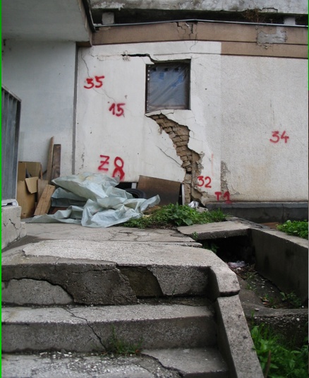 | Figure 9. Cracks on the building and marks for observation Dalmatinska street in the Sarajevo Canton [1] |
3.4. Monitoring System
- In areas where have been noticed traces of soil motion and cracks on objects, it is necessary to immediately establish monitoring, which has the task of indicating the displacement sizes, and their increment with time (Fig. 9).The landslide monitoring is based on three methods of monitoring. Since 1999, the three types of monitoring have been applied in Sarajevo Canton: geodetic monitoring, piezometer monitoring, and installation of inclinometer for geotechnical monitoring system.If sudden increase in movement of soil, or open cracks on objects are noticed, then it is necessary to intervene urgently, and make further decisions with the help of specialists in this field. This task can be accomplished through frequent field observations, then installation of glass tiles on cracks, and direct measurements of cracks in the field, where the measurements should be made between pre-fixed wooden pickets (Fig. 10).
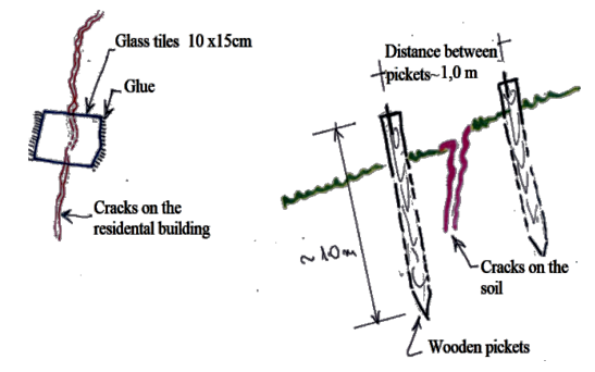 | Figure 10. Marks for landslides monitoring (with glass tiles and pickets) |
4. Conclusions
- Bearing in mind that landslides can happen everywhere around us, the certain patterns and descriptions are used for different activities about landslides and have to be used for landslides prevention and damage control.Systematization of landslide type data, velocity of movement, trigger mechanism, effects, corrective measures / mitigation, predictability and warning system are basic data information, collected on site and recorded for longer period in order to implement an appropriate landslides management and activities for mitigation.The research of numerous landslides in the territory of the Sarajevo Canton concluded that the causes of the occurrence of these events are also natural and anthropogenic caused by human activity on the slopes of the terrain.• The most important natural causes are related to the very complex geological structure and the unfavorable engineering-geological and hydrogeological properties of surface coverings and geological substrates, and also for the influence of surface and ground waters, climate regime (type and length of precipitation) slope of terrain, etc.• The most typical of the artificial causes are: Construction of residential buildings and facilities of communal infrastructure on the slopes, conditionally stable and unstable parts of the city without any previous geotechnical researches, undercutting of slops, and uncontrolled spillage of surface waters in the field, deforestation, damaged sewer and water supply network as a war consequences, etc.The Sarajevo Canton as a priority attempts to suspend the illegal construction of residential buildings and implement corrective and mitigation measures.According to the data of the Institute for Construction of the Sarajevo Canton, in the period from 1998 to 2018, about 23 Mil EUR was spent on correction measures and mitigation of the consequences from the landslides [7]. In addition, there is continuous work on improving the database, adequate data processing and the adoption of planned measures to improve the situation on the ground. Citizens of the Sarajevo Canton are timely notified about potential dangers from the landslides. However, despite all measures and caution, characteristic of topography and landslide patterns recorded over the years require continues efforts to be invested in dealing with this challenging issue.