Gatesi Jean de Dieu 1, Byiringiro Emmanuel 2, Abijuru Theoneste 2, Nsengiyumva Daniel 2
1Assistant Lecturer, Department of Civil, Environmental and Geomatics Engineering, CST-University of Rwanda
2Bachelor Students, Department of Civil, Environmental and Geomatics Engineering, CST-University of Rwanda
Correspondence to: Gatesi Jean de Dieu , Assistant Lecturer, Department of Civil, Environmental and Geomatics Engineering, CST-University of Rwanda.
| Email: |  |
Copyright © 2020 The Author(s). Published by Scientific & Academic Publishing.
This work is licensed under the Creative Commons Attribution International License (CC BY).
http://creativecommons.org/licenses/by/4.0/

Abstract
Today’s traffic movements in Kigali-city experience the traffic jams especially during demand peak hours when a great number of vehicles moving in the streets are being disturbed by vehicles parked along the curbs of the streets with inadequate width to serve as a roadway and parking at the same time. There are also other vehicles parked illegally causing traffic congestion in the streets and disturbing the services provided according to the land use. This study aims to conduct a parking demand assessment on parking facilities available in Nyarugenge CBD, making the parking inventory study and land use study so that the results of those studies are used in providing an effective parking management tool to reduce traffic jam issues related to inadequate usage of on street parking facilities. Both public on street and off-street parking facilities have been surveyed and the results show that the average level of usage of on street parking is 83.35% while that of off-street parking is 65%. The results also show that longer jam moments occur in hours where on street parking facilities are at high level of usage (around midday) and the jam recorded with longest time has been found to spend 92 seconds.
Keywords:
Traffic jam, Inventory study, Parking demand management, Parking facility, GIS application
Cite this paper: Gatesi Jean de Dieu , Byiringiro Emmanuel , Abijuru Theoneste , Nsengiyumva Daniel , Geospatial Study on the Parking Demand Management in Kigali City, Rwanda, International Journal of Traffic and Transportation Engineering, Vol. 9 No. 3, 2020, pp. 49-61. doi: 10.5923/j.ijtte.20200903.01.
1. Introduction
Traffic congestion is a situation where a large number of vehicles are moving in a road which has insufficient capacity to serve the road users. At this situation, traffics spend much time standing at the same point or move at very low speed with difficulties. Traffic jam is mostly experienced by countries with high traffic growth rate of vehicles which exceed the capacity of the transportation facilities like roads and parking places which are in use at that moment.Rwanda is a country which is developing and many people are buying cars and others are going abroad for commercial purposes. This quick progress has increased the number of traffics in Rwanda roads especially in the cities, which has leaded to the traffic jam. As this situation has a great negative impact on the economic development of the country and the well-being of people, it is of paramount importance to work on how this issue can be sorted out. This study focusses on the assessment of traffic demand for parking places through determination of the extent of usage of available parking facilities and their impact on the appropriate transportation required. Both services offered by on street and off-street parking facilities have been assessed and from the results obtained we have provided some of the solutions which can reduce the traffic jam associated with deficient parking management in our Central Business District.Road transportation has been a good way to serve a great number of people to get at work on time, to speed up transport of goods and delivery of services. An effective transportation makes a great influence on the entire development of a country.However, current parking system available in the Central business District of Nyarugenge sector devastates the qualified transportation required in the city. To treat some streets both as roadway and parking has led to traffic jam in the roads, which also give rise to many problems like increased travel time, disorder, difficulty in traffic control, slowing down of the rate of foreign investments due to poor transportation in the region and great possibility of accidents which bring about losses of people’s lives as well as property damages.Though government has established rules governing traffic movements, that strategy serves in reducing the traffic jam only related to the discipline of drivers in respecting street directions and indications of traffic signals but that strategy cannot solve this issue completely because the inability of drivers to be aware of services offered by off street parking facilities causes them to disregard intentionally the significance of no parking signs available at some streets and park illegally. This study has assessed the traffic parking demand in Nyarugenge CBD and find out means by which the parking demand can be satisfied by available parking supply once tools like GIS map and an android application are used to provide information which can help drivers to know and park where non congested parking facilities are located, and through this strategy traffic jam problems related to inadequate parking usage will be addressed to considerable extent. The main objective of this research paper was to conduct a parking demand assessment and provide a GIS map as a tool for parking management once it provides helpful parking information to drivers for them to find parking places easily.This study assumed the following hypothesis:√ Parking demand assessment is a major step in establishing an effective strategy for parking management.√ Land use types available in the area influences significantly its traffic movement.√ GIS map is a parking information provider to drivers.
2. Significance of the System
This study is limited on assessing the parking demand from which its results have been used to establish parking management means which reduce the traffic jam resulting from current unimproved parking management. Only public parking facilities were surveyed because they are the ones having a great influence on the traffic jam in the city. Supply survey have been conducted on each and every parking facility considered in the study but the demand survey was conducted on selected two mostly used off street parking facilities and one block of on street parking places made by a minimum of three streets. Only small cars and medium size vehicles have been considered. With little availability of land to accommodate high traffic demand in Nyarugenge CBD, there is a need for a proper traffic management which will enable the optimum usage of available transportation facilities. Initially, current facilities were designed at low capacity and there was no proper forecasting of the demand which is in place to day. From this point of view, research for finding economic feasible ways to address problems resulting from incapacity of facilities is very paramount and as the financial means can be found, deep researches can be conducted which may lead to major decisions like the extension of current facilities or introduction transit systems. When a driver is travelling from one place to another seeking the parking place without knowing the true direction of where free parking places are likely to be, it takes him/her a long time and may disturb the daily program of his/her activities. Thus, producing a GIS map for parking system will serve as many local people as possible but also foreign people who are not familiar with Kigali will find an easy way to get helpful information about parking services in the CBD. Furthermore, data collected and results of this study will be used by agencies and institutions with traffic management in their responsibilities, since there is a need to develop Rwandan manuals clarifying the parking system in the city and how they should be used.
3. Literature Survey
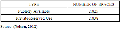
Parking demand and supply are two collaborate issue, where parking supply represents all parking spaces around the study area such as private, public, on-street and off-street and parking supply is determined by considering all available parking spaces in given region such as central business district. Parking supply reflects the response of parking demand at some level. Both parking supply and demand are useful in parking performance evaluation as soon as number of legally and illegally parked vehicles were recorded (Nicholas J.Garber, Lester A. Hoel, 2009). The study conducted on parking supply of Portsmouth provided the following result (Nelson, 2012).Table 1. Private vs. Public supply in Hamilton city
 |
| |
|
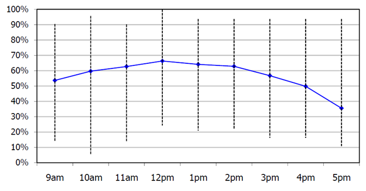 | Figure 1. On Street parking demand in Hamilton city, Source: (Hamilton, 2017) |
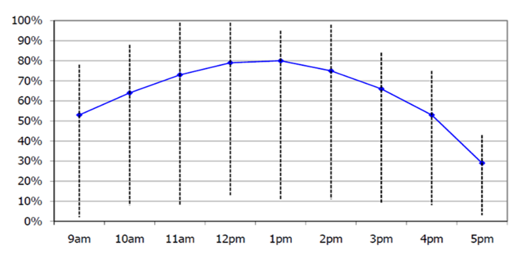 | Figure 2. Off Street parking demand in Hamilton city, Source: (Hamilton, 2017) |
On street parking demand survey in Hamilton central and Hamilton east along daytime showed that weekday demand peaks in the middle of the day at 66% average before declining in the afternoon as represented by graph on Figure 1 above. Furthermore, off street parking demand has also been determined and in the same way it peaked in the middle of the day and decreased in the afternoon as the graph on Figure 2 above shows. (Hamilton, 2017).Moreover, in providing adequate supply to a given demand, land use generated parking need should be considered to effectively save the land space. The following figure describes how parking demand is highly influenced by land use type.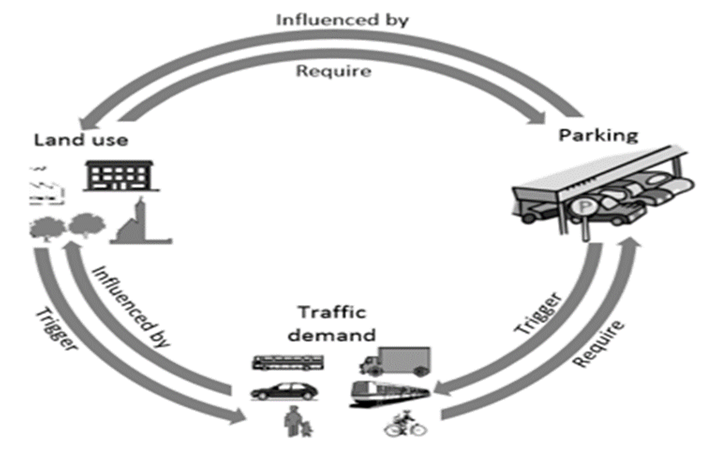 | Figure 3. Land use influencing parking demand, Source: (Chaturvedi, 2012) |
In Korea, parking demand study were conducted on-site survey and analysed the variables of on-street parking which was the mainly based on the number of vehicles and parking occupancy present, this involves 19 legal precincts in Dong-gu, Daegu, Republic of Korea which reflect the general characteristics of on-street parking. To analyse the on-street parking demand variables that illustrate the on-street parking condition at both day and night time, they had conducted the survey both at day and night time. Among a total of 43,393 parked vehicles, 4,885 vehicles (11.26%) were parked in legal parking zone, 23,678 vehicles (54.57%), were illegally parked on local streets, and 12,198 vehicles (28.11%) were illegally parked in parking prohibited zone (Lee, 2015). Mapping in research is a tool that helps to represent current situation of the case study, analysis and decision making of what should to be done to solve the issue. Maps were used to represent the parking issue related to interaction between supply, price and resulting demand for parking. Inventory of any existing parking refers to collecting details of information about location, whether the parking is public or private, total number of available parking spaces, parking fees and method of its collection and types of vehicles that are restricted to use the facility. (Nicholas J.Garber, Lester A. Hoel, 2009). This is very much useful to know the condition of the parking to predict, its future performance and make adequate decisions which can better help to improve service it provides. Rwanda building code- 2015 that was prepared under the authority of MININFRA recommends that 3 m by 6 m should be provided as a minimum space for individual car parking and 2.5 m by 5 m for common parking space in off-street parking. (MININFRA, 2015). Is obvious that the more the stall size the greater will be the comfort of the parking users. But care should be taken that the space is used economically.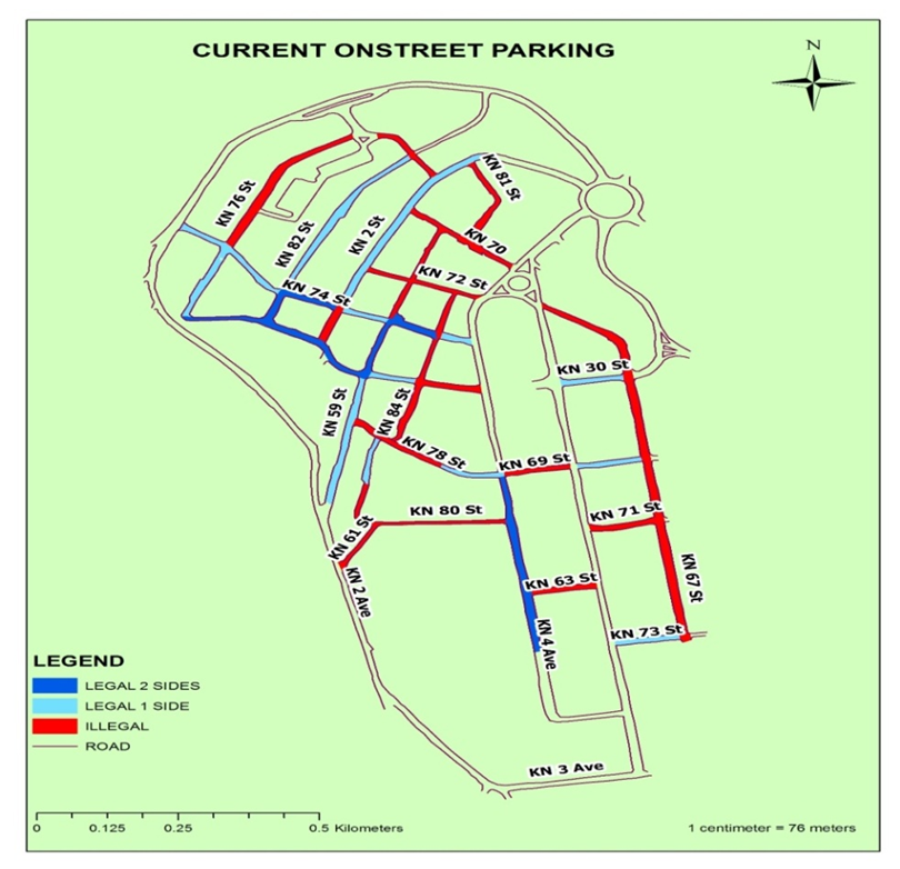 | Figure 4. Current on street parking in Nyarugenge District, source: Map drawn by Gatesi et’al |
4. Methodology
1. Framework of research study 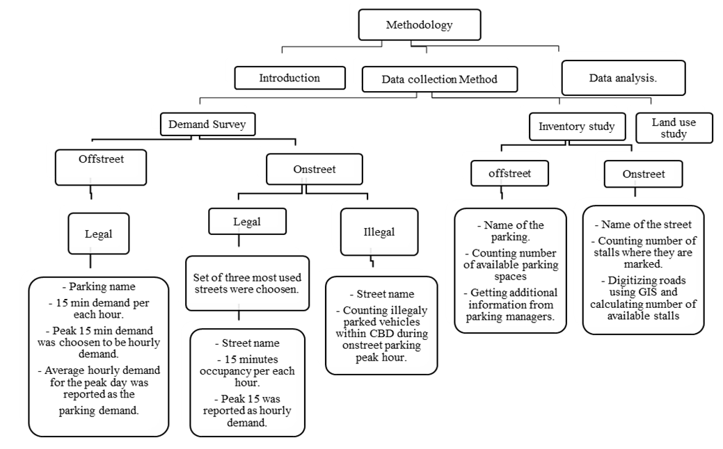 | Figure 5. Flow chart of research Methodology |
The above figure describes the research methodology process and shows how the relevant data could be collected both on street and off street parking location. Case study of this research is located at CBD of Nyarugenge in Kigali-City. Where the number of vehicles were counted according to the selected parking location. In this flow chart figure also shows the GIS software application and the production of map. Finally the results from the data collection were analysed by using graphics and creating the parking software application which can guide the drivers in order to find the free parking location easily.2. Location of the case studyIn this research paper, the selected case study location was Nyarugenge District located in Kigali-City, Rwanda. It is a location where the manly commercial business could take place and is known as centre of business district (CBD) of Kigali-city. In this case study, there are so many personally and commercial vehicles parked on or off street parking which can create the traffic jams. 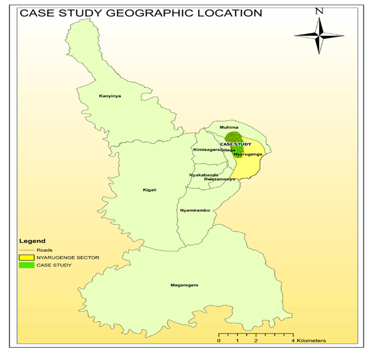 | Figure 6. Case study location within Nyarugenge District, Source: Map Drawn by Authors |
3. Data collection and processingPrimary data have been collected using quantitative method where vehicles were counted, and our target sample were made of small and medium size vehicles like cars and pickups. During inventory study, we made a record of parking places and parking fee for all public parking facilities, and we also looked at any other relevant information like regulations and toll collection methods.Demand and Supply surveys have been conducted to assess whether the current available parking places are sufficient for the parking demand. We have conducted demand surveys at both off street and on street parking facilities. For the purpose of making clear accurate inventory, two representatives off street public parking facilities were considered and three streets were combined one block.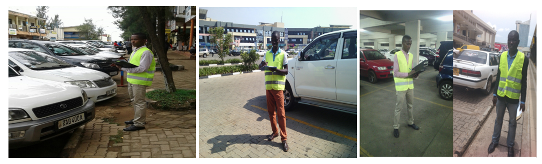 | Figure 7. Photo of researchers during on & off street data collection at Nyarugenge District, Kigali-city |
5. Data Analysis and Results Discussion
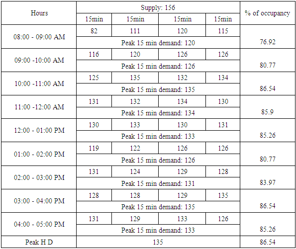
1. On street parking demand data analysis First street section surveyed is the section of street KN 2 St from junction with KN 70 St and KN 72 St. This Street starts from Kigali City Market passing at City plaza, KCT to main roundabout, section surveyed is the one from City plaza. The second street section surveyed is the section of street KN 74 St and it starts from Kigali City Market to Madina Mosque. The third street section is on street KN 59 St starting from Madina Mosque to Glory Hotel.The records in highlights indicate the peak records and their respective peak hours where the parking was being used highly than at other times. The following graph shows the fluctuation in on street parking demand at this typical weekday.Table 2. On street legally parked vehicles data collection
 |
| |
|
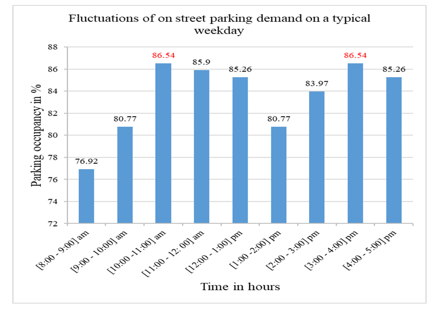 | Figure 8. Fluctuations of on street parking demand on a typical weekday |
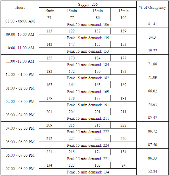
2. Off street parking demand data analysisFor the purpose of collecting demand data at off street parking, facilities expected to be highly used than others were selected. The selected facilities are UTC parking and CHIC parking. CHIC parking is an outdoor parking located just in the down part of Nyarugenge CBD near the main roundabout big shops in the zone of high retail commercial services. From that point of view, it was expected to be among the most used off street parking facilities. Table 3. Off street legally parked vehicles data collection at CHIC Building
 |
| |
|
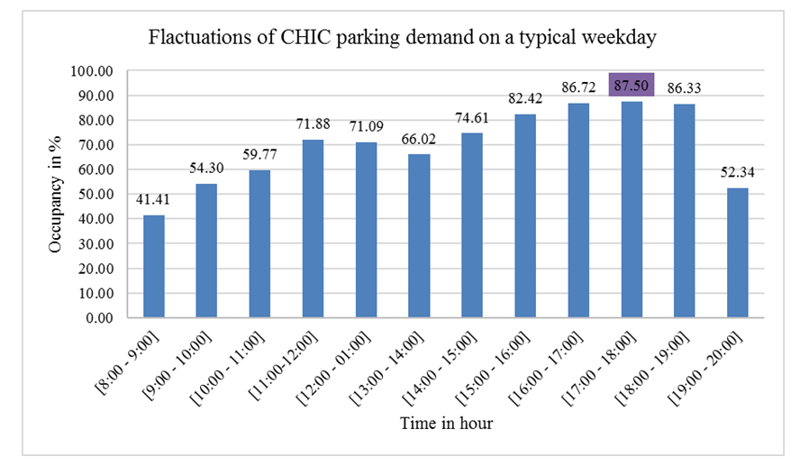 | Figure 9. Off street CHIC parking occupancy fluctuations |
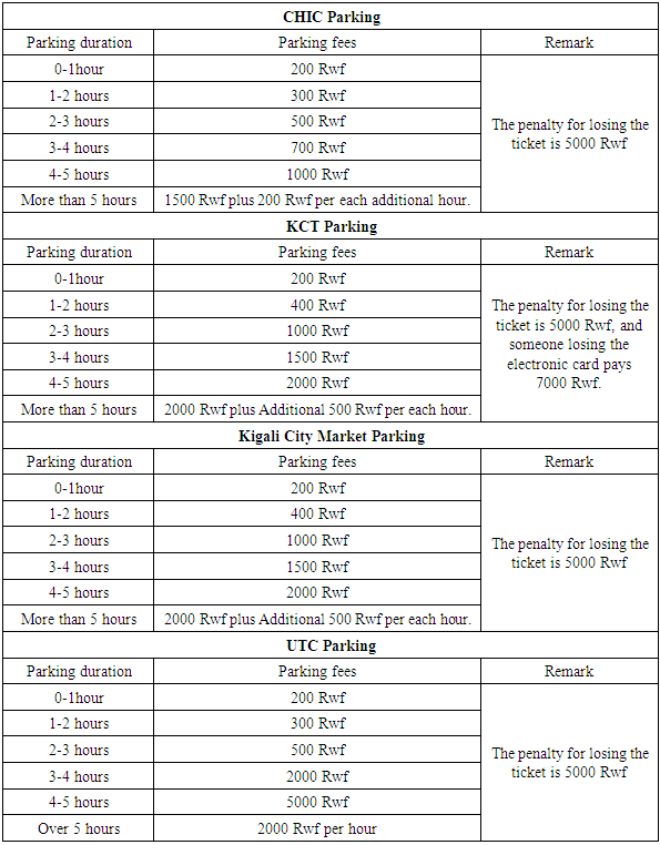
3. Inventory data studiesTo conduct inventory study for on street parking places, only streets where the parking is allowed were considered in the survey. This means, streets with either a parking sign marked as “PAY AS YOU PARK” or having at least drawn stalls and without a no parking sign prohibiting the parking at that street.The inventory study of public off street parking facilities has been conducted at seven big parking facilities in Nyarugenge CBD namely CHIC parking, Grand Pension Plaza parking, Kigali City Tower parking, Centenary House parking, M.Peace Plaza parking, UTC parking and Kigali City Market parking. During the study, we had conversations with parking managers in order to get accurate information for every aspect taken into consideration in our study. Information collected at each parking is detailed here below:Table 4. Parking fee Structure at CBD of Nyarugenge Distriict, Kigali-city
 |
| |
|
4. Land use studyLand use study has been conducted by moving all around in our case study to determine which types of activities are mostly performed in this location. From that point of view, four main land use types have been identified where we found that this land is occupied by Retail commerce one, Wholesale mixed with Retail commerce zone, Education and Hospitals zone and finally Hotels and Administration zone. All of these different land use types influences the parking and traffic movements conditions in this location. Here below is the map showing those land use types identified in the case study area. During our study, much of parking problems have been found in the retail and wholesale mixed with retail commerce zone due to the fact that in this area is where there is many traffics from people coming to buy products and services and others are sellers and service providers. In the zone of Education and Hospitals and zone of Hotels and Administration, there are no jam problems related to parking facilities found there, except vehicles found parked where it is not allowed due to the fact that there is not a sign indicating the presence of parking or they are just parked where there is a no parking sign.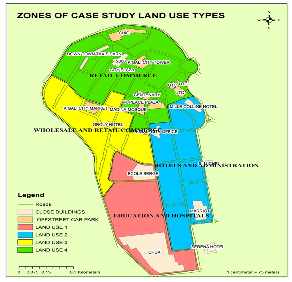 | Figure 10. Land use types in Nyarugenge CBD, Source: Map drawn by Authors |
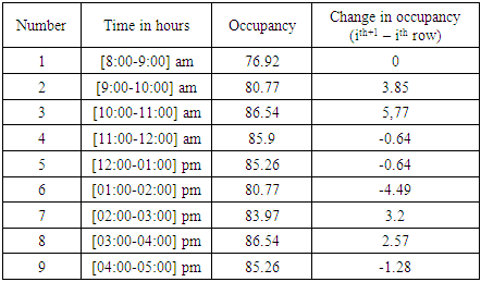
5. Data results discussionFrom the data of a busiest day as illustrated by the bar chart on Figure 8, occupancy varied from 76.92 percent to 85.26 percent from 8:00 am to 5:00 pm. Peak occupancy of 86.54 percent was reached in the third hour of the count [10:00 – 11:00] AM as well as in the eighth hour of the count [3:00 -4:00] PM. Recalling that the land use of the area is commerce, the correctness of the data is proven by the day to day running of business in central business district. Friday in Kigali people purchases at large number preparing for the week-end and it is on this day that provincial traders purchases in intense quantity. Furthermore, people reach the job in at great intensity from [10:00 – 11:00] AM hence a large occupancy increase of 5.77 percent occurs in this hour. In addition to this, in that same hour clients purchases in large number. Moreover the [3:00 – 4:00] pm peak corresponds to evening clients purchasing.Table 5. Rate of change of occupancy
 |
| |
|
The above table shows the change with time in occupancy. Positive values show percentage of vehicles entering on street parking relative to the previous hour whereas negative values show the percentage of vehicles leaving the parking stalls. The peak hour was characterized by the largest increase in occupancy of 5.77 percent for the reasons explained before. This was followed by the smallest constant decrease of 0.64 percent for two hours. In fact, from 11:00 am to 01:00 am the parking was almost around its full capacity and there were no much movements of in and out in the parking stalls.Depending on the use of the building, off street parking facilities surveyed have got different demands. How well a given parking serves the demand classifies its service condition. The classification also informs about how users of the facility are comfortable with the existing conditions. For example, during the survey at UTC someone could pay to enter while no more spaces are free inside, which created conflicts between customers and parking management team. Referring to TGP Consultants, Morro Bay city Final-Parking Management report-2007, parking facilities can be classified as:√ Acceptable and not representative of a significant parking supply shortage if demand is below 75%. This shows that 25% or more of the parking spaces are free.√ Early-warning of a potential emerging supply shortage if parking demand is between 75% and 85%. √ Critical parking need (hot spot) if demand ranges between 85% and 100%. This means that 15% or less parking spaces are free. At this point it is very difficult and time consuming to find a parking stall. √ Immediate supply shortage if demand is over 100%.6. GIS Mapp software applicationCollected data for on street parking shows that they are used at an average usage of 83.55%. The occupancy of on street parking is greater than 75% all along the hours of the day. Moreover, most of off-street parking facilities have got the occupancy which is below 65%. These results show a need for orienting drivers know off street parking that are close to them to be used in reducing pressure on street parking. We have managed to provide a map for current parking system that is supposed to help in finding easy location of parking facilities within Nyarugenge CBD. A map like this one has been uploaded at Arcgis.com to facilitate its easy sharing online using social media or any other means of communication. 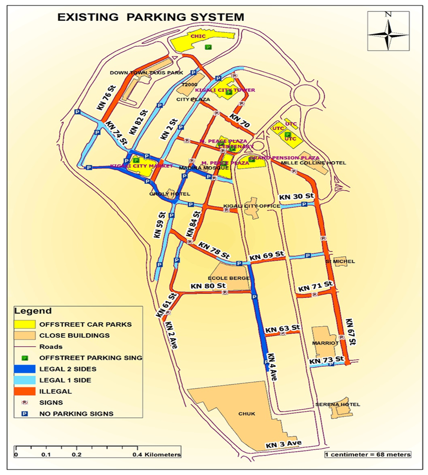 | Figure 11. GIS Map showing locations of parking facilities in Nyarugenge CBD |
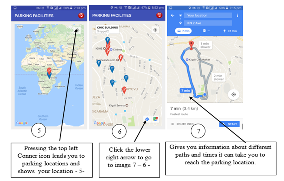
In fact, a GIS Map either as hard copy or online map can solve the issue of lacking information about parking locations but it might take time to access this map very easily. To handle this issue, we have worked with other people from with programming skills to develop an android application that can easily be downloaded from play store and installed in telephones and tablets so that anyone with an internet connection can access easily information about parking facilities in Nyarugenge CBD. Therefore, there will be no more jam or traffic problems related to large number of vehicles stacked at narrow streets or spending much time searching for a parking in the CBD. Below are mobile phone screenshots showing step by step for using that application.It was realized that cost of on street parking is very low compared to off street parking cost. Keeping parking as private makes owners to set prices as they want only for-profit maximization. Hence measures to legalize adequate prices which make parking affordable to drivers are needed for off street parking facilities. Availability of on street parking in CBD appears to be an arrangement to serve a tremendous increase in demand. Because most of current roads widths are not compatible with on street parking, this was clearly since when a vehicle is entering or exiting in the stall, lane movements are disturbed. Moreover, some roads were simply made a parking yet there is a no parking sign and no stalls are drawn for parking. Inefficiency of existing on street parking lead us to suggesting another platform that could reduce jam and allow proper land management by effective usage of on street place.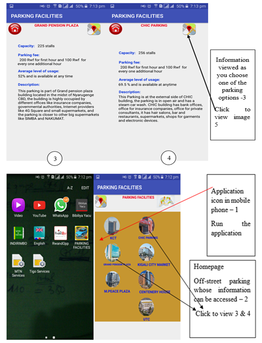 | Figure 12. Screen shoots showing parking application location, Source: Telephone Screen shoots made by Authors |
 | Figure 13. Screen shoots showing operations of parking application, Source: Telephone Screen shoots made by Authors |
6. Conclusions and Future Work
This research has come up with the real picture of current parking conditions both for on street and off-street parking facilities in Nyarugenge CBD. It has also provided GIS map and an android application as tools for traffic management in the street movements, these tools are also helpful in responding to drivers’ need for getting a quick and reliable parking whenever is needed. Through field surveys of two selected highly used off-street parking and three busiest sections of on street parking and with the help of analysis made from data, the following conclusions were taken:√ Current system of on street parking facilities contribute to jam moments in traffic movements. The highest jam duration recorded has been found to 92 seconds around the peak hours. Drawn stalls at some streets were done without much consideration of how vehicles would enter and exit as these movements are the liable for a high rate of this type of jam.√ To find on street parking whose average level of usage is 85% while for some streets and in off street parking have very low level of usage like 26% this indicates an improper usage of land available which also induces jam problems.√ Cost of on street parking is low compared to that of off-street parking. 100 Rwf per hour per stall is charged for on street parking, which becomes only 500 Rwf when a vehicle is parked more than five hours and the monthly payment is 10,000 Rwf. On the other hand, minimum hourly cost to park in off-street parking is 200 Rwf which increases with time and the monthly payment is 30,000 Rwf.√ Currently, there are no Rwanda guidelines available for parking facilities to assist in parking management and inform designers about adequate dimensions for stalls with regard to vehicle size. This has an impact to lacking accurate data about a number of vehicles that a given facility can serve satisfactorily.√ Most of off-street parking are used at an average that is below 65%. M. Peace plaza parking has been found to be the lowest used parking while its nearby streets experience illegal parking conditions.Future researchers, to go deep into research related to solving jam problems resulting from improper usage of on street parking and conduct the feasibility study for the removal of on street parking with an introduction of transit system, we would recommend future researchers, to also conduct a feasibility study for the extension of current transportation system and prove further reasons for the removal or maintaining the usage of on street parking. Autonomous vehicles are also recommended for future study.
ACKNOWLEDGEMENTS
This research work was prepared with the purpose of creating geospatial parking management tools which could be used by the drivers in Kigali-city. During this research, the data were collected in Nyarugenge District under the authorization of Kigali-city and Rwanda National Police, department of road traffic safety. Briefly authors acknowledged the all institutions contributing their efforts in order to achieve this research work. Finally, we acknowledge the College of Science and Technology-University of Rwanda for the supports during this research work.
References
| [1] | Access hamilton, 2010. Parking Management Action Plan, New zealand. p, 21. |
| [2] | Alamy, 2017. A large number of vehicles stuck in traffic jam due to illegal parking in Karachi, Japan. |
| [3] | Chaturvedi, M., 2012. Parking in balance: A Geospatial analysis of efficiency of the parking system of Enschede, University of Twente, The Netherlands. |
| [4] | Cheng, T., Miaomiao, T., 2012. The model of parking demand forecast for the urban CCD, Elsevier, Tianjin polytechnic university, China. |
| [5] | Geok, K. Kuah, 2011. Estimating Parking demand for mixed use developments subject to TSM ordinances, Institute of Transportation Engineers, New York. |
| [6] | John G. Shaw, 2007. Planning for parking, University of Iowa, Public policy center for the US department of transportation centers program, Iowa. |
| [7] | Junior, C. G. D., 2010. Vehicle traffic management and GIS Planning system, Curitiba: Victor Ferreira. |
| [8] | Lee, Y. W., 2014. Study on Establishment of On-street Parking Demand Model using Data by. International Journal of Applied Engineering Research, vol.9 (No.24), p. 292. |
| [9] | Lee, Y. W., 2015. Study on the Variables for On-street Parking Demand Estimation through parking survey, Daegu: Jill Yang. |
| [10] | Transport safety Engineering 2012, Line marking of Parking Spaces, Council community, City of Port Phillip. |
| [11] | Ministry of Infrastructures, 2015. Rwanda building code, Kigali, First edition, p. 171. |
| [12] | Nelson, 2012. Parking supply and demand analysis final report, Portsmouth: Nygaard Consulting Associate Inc./47. |
| [13] | Nicholas J.Garber, Lester A. Hoel, 2009. In Traffic and Highyway Engineering. Fourth ed. s.l.:Cengage, p. 144. |
| [14] | Todd, L., 2016. Parking Pricing Implementation Guidelines, Victoria Transport Policy Institute, Victoria City, British Columbia. |
| [15] | TPG Consultants, Inc., 2007. Final Parking Management Plan,Spply and Demand Analysis, Morro Bay City, California, p. 15 - p. 27. |
| [16] | Wilkie C. H. Lam, 2009. The Hong Kong parking demand study, Proceedings of the institute of Civil Engineers: Transport. University of Hong Kong, University press, Hong Kong, p. 219. |

 Abstract
 Reference
 Full-Text PDF
 Full-text HTML