Javed Bari1, Kazi Md Shifun Newaz2, Quazi Rokaiya Haque1, Md. Nawfal Ahmed1, Faria Tabassum1
1Department of Civil & Environmental Engineering, North South University, Dhaka, Bangladesh
2Accident Research Institute, Bangladesh University of Engineering & Technology, Dhaka, Bangladesh
Correspondence to: Javed Bari, Department of Civil & Environmental Engineering, North South University, Dhaka, Bangladesh.
| Email: |  |
Copyright © 2019 The Author(s). Published by Scientific & Academic Publishing.
This work is licensed under the Creative Commons Attribution International License (CC BY).
http://creativecommons.org/licenses/by/4.0/

Abstract
The main purpose of this paper is to present the findings of an investigative research conducted on the source, nature, frequency and severity of the road safety risk factors associated with the major school zones of the capital of Bangladesh – the Dhaka City, where about 20 million people reside. In the absence of adequate local research in this field, this study was deemed very important. In this study, a school zone road safety risk rating system has been developed using a scientific and legitimate algorithm for determining the actual safety situation of the school zones. The risk factor identification has been done based on real data. The study proposes an index system to sort qualitative data obtained from surveys conducted during the study and convert them into quantitative data. Related traffic accident data were analysed. By using the school zone road safety risk rating system developed in this study, it was possible to accurately identify the risk rating of any particular school zone of the study area; ranging from low to high. The proposed technique can be replicated for any school zone in a big city like Dhaka in order to identify the road safety situation particularly for the school students, which will help in safety enhancement operation and future planning of the city.
Keywords:
Road Safety, School Zone, Risk Factor, Risk Rating
Cite this paper: Javed Bari, Kazi Md Shifun Newaz, Quazi Rokaiya Haque, Md. Nawfal Ahmed, Faria Tabassum, Development of a School Zone Road Safety Risk Rating System for Dhaka - the Capital City of Bangladesh, International Journal of Traffic and Transportation Engineering, Vol. 8 No. 3, 2019, pp. 72-79. doi: 10.5923/j.ijtte.20190803.03.
1. Introduction
Globally, about 1.3 million people die due to road accident every year; over 96% of the total death and 85% of casualties in children resulting from road accidents are from low and middle-income countries like Bangladesh (Ahsan, 2012). Children involved in road accident fatalities in Bangladesh are at least 2.5 times higher than that of any other developing countries; over 16% of all the road accident casualties have children being the victim of it and a surprising 20% of all the fatalities victimize children in it (Ahsan, 2012). In Bangladesh, the 6-14 years age group is the most vulnerable and at the most risk (UNICEF, 2003 and 2008). In 2015, 517 children died from road accidents, which was about 28% of total 1,860 children who died in Bangladesh from various mishaps including road accidents, rape, domestic violence, abduction, drowning, etc. (Jaki, 2016). Research revealed that 21% of total people dying in Bangladesh due to road accidents were children below the age of 16 years (Anjuman and Siddiqui, 2007). Majority of the road traffic accidents either caused fatality, which had a possibility of 69% or they fall under the category ‘hit a pedestrian’ which had a possibility of 60% (Ahmed, 2012). Children are more susceptible to get injured in an accident than adults. Probability of children being the victim of injuries and death are very high (Rahman et al., 2005). Evidently, the age group containing the school going children students is extremely vulnerable to road accidents in Bangladesh. Unfortunately, no in-depth research has been done to identify and solve the road safety-related risks at the school zones of Bangladesh. This study, therefore, was deemed very important to conduct.
2. Objective, Scope and Limitations
The main objective of this study was to investigate into the school zone road safety situation of greater Dhanmondi-Lalmatia-Mohammadpur Area of Dhaka City in a systematic and scientific way in order to come up with practical solutions to identify the sources of road traffic accident-related risks and pave way to enhance the school zone road safety in this study area. The scope of this research included conducting literature research, analyzing the road traffic accident data of the study area, identifying, shortlisting and finalizing the risk factors affecting the road safety situation of the study area, determining the impacts/damages resulting from the road safety risk factors, developing and calibrating a school zone road safety risk rating system using a scientific and legitimate algorithm. The school zone road safety risk rating system developed in this study can be locally calibrated and used for school zones of Dhaka and similar metropolitan cities. A key point of the study conducted was to investigate whether the study schools or corresponding authorities provide any sort of protection to reduce the number of accidents, and if so, to what extent and type. The reasons behind the current school zone road safety situations have been analyzed and ways to enhance school zone road safety have further been suggested. It is noteworthy that access to road accident database from 2012 through 2017 was restricted during conducting the study as it was undergoing final scrutiny and quality checking. Hence, this study focused on road accident data from 2001 through 2011.
3. Literature Review
3.1. Background of the Problem
Entanglement of school-going children in road accident casualties and fatalities is a major road safety-related global problem in low to middle income developing countries like Bangladesh, especially in highly populated mega cities like its capital Dhaka. It cannot be denied that a lot of young people aged between 0-17 have demised due to road accident fatalities as it is now the leading reason of death among children. Not only fatalities but a large number of children also suffers from injury, which may bring temporary or permanent disability. An in-depth literature review has been done in this study; the key aspects retrieved from that review are as follows:• Road traffic accident has been the dominant cause of death in Bangladesh among the age group between 6-14 years (Rahman et. al, 2005; UNICEF 2003 and 2008).• The peak hour of road accidents having those children as a victim is between 10 am and 12 pm that is naturally the time when the younger children in the urban area return home from school (Anjuman, 2007). • Out of all road accident fatalities during 1998 and 2004, 21% involved children. In this 21% children fatality, 82% were pedestrians. On the other hand, 32% of all pedestrian fatalities involved children; 56% of this children fatality is from the age group of 6-10 years (Anjuman, 2007).• Majority of the road traffic accidents either caused fatality, which had a possibility of 69% or they fall under the category ‘hit a pedestrian’ which had a possibility of 60% (Ahmed, 2012).• Children are more susceptible to get injured in an accident than adults. Probability of children being the victim of injuries and death are very high (Rahman et. al, 2005).
3.2. Aspects Revealed and Lessons Learned from Case Studies
A good number of case studies on road accidents involving school going children of Dhaka City were reviewed for this study from the national newspapers (Dhaka Tribune, 2017; The Daily Star, 2010 and 2016; Bangladesh Sangbad Sangstha, 2016; Bdnews 24, 2016). They revealed some common important aspects, which are as follows:• Pedestrians who were between 4-17 years old are vulnerable road users.• ‘Hit a pedestrian’ was the most common scenario among all road accidents.• In most cases, traffic was not managed properly.• Traffic laws were not maintained properly by both road users and traffic police. • Traffic signals were not followed by people.• Reckless driving was dominant in the major arterials.The common lessons learned from these cases are as follows:• Proper usage of zebra-crossing and foot-over bridge should be ensured.• To avoid accident it should be checked if there is any approaching vehicle before crossing the road.• Road should not be crossed in a hurry.• Where available, help from the traffic police should be taken for crossing the road, especially if there is high volume of vehicles.• Proper traffic management and maintenance of traffic law should be ensured.• Traffic signals should be followed while crossing the road. • Public and private transports should not be driven recklessly.• Public transports should not be stopped anywhere other than the designated bus stops.
4. Methodology
4.1. Selection of Study Area
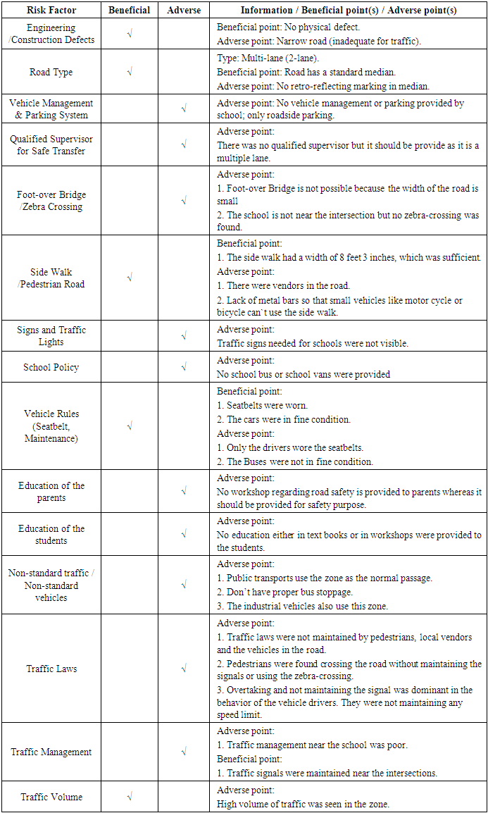
The areas of influence were Lalmatia, Dhanmondi and Mohammadpur. The road accident data confirmed that an alarming number of traffic accident take place on parts of Mirpur road that is a principal arterial, parts of Satmosjid road that is a major collector, and Asad Avenue Dhanmondi Road #16, Road #Old 27 and parts of Road#2 that are minor collectors. Therefore, these roads were considered in this study. Schools that were considered in the study are those situated beside the selected roads. Ten schools were selected based on cluster and random sampling out of total 20 schools in the study area. The schools were then clustered into eight school zones based on vicinity, which are as follows:(1) Zone 1 included Dhanmondi Government High School;(2) Zone 2 included St. Paul Mission School;(3) Zone 3 included (i) St. Joseph School and (ii) Mohammadpur Preparatory School and College; (4) Zone 4 included (i) S.F.X. Green Herald International School and (ii) Mohammadpur Preparatory School and College Pre-Section; (5) Zone 5 included Academia School;(6) Zone 6 included Sunbeams School; (7) Zone 7 included Oxford International School; and (8) Zone 8 included Dhaka City College. The study area is shown in Figure 1 (the major roads are shown in solid red color).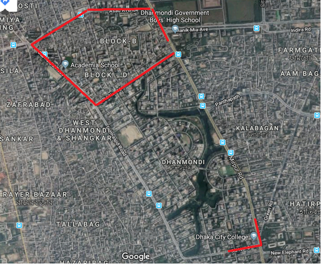 | Figure 1. Study Area (courtesy: Google Earth) |
4.2. Risk Factor Identification Process
Identifying the road safety-related risk factors was a major task as it had the ability to shape the research work. This process was accomplished in a loop with three major steps: (a) Identifying factors, (b) Making questionnaire, and (c) Field visit.
4.3. Accident Data Extraction and Analysis Process
Recent 11 years’ (2001 to 2011) detail road/traffic accident data were retrieved from the Accident Research Institute (ARI) of Bangladesh University of Engineering and Technology (BUET), which were further filtered and re-arranged using the Microcomputer Accident Analysis Package, Version 5 (MAAP5) software (Baguley, 1994). The years were divided into the following two groups to identify any change in accident pattern: (i) 2001-2005, and (ii) 2006-2011. Specifically, the following parameters were extracted for analysis: Day of the week, Accidents by time, Accidents severity, Accidents by weather, Accidents by light, Accidents by surface condition, Accidents by collision type, and Accidents by traffic condition.
4.4. Condition and Collision Diagrams of Adjacent Roads
Next, condition and collision diagrams were drawn for each school zone to get an idea of the susceptible places where the accidents had occurred, which would prove the hypothesis that the identified safety factors were the reasons behind the specific road safety condition of any particular school zone. Putting all these data, the study came up with a matrix or algorithm that assigned a specific ‘rating’ of the schools and school zones according to their respective safety factors.
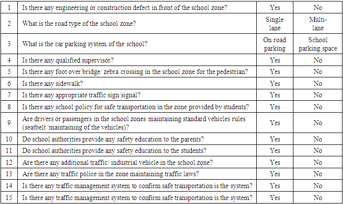
4.5. School Site Survey
A school site survey was conducted for which a standard questionnaire was developed, as shown in Table 1.Table 1. Survey Questionnaire
 |
| |
|
4.6. Risk Assessment from Field-obtained Information
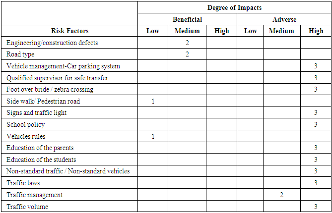
Each risk factor was assigned a “Low”, “Medium” or “High” rating with a corresponding index value of 1, 2 or 3, respectively, according to their role in road-safety-related risk. The cumulative index value indicated how safe the school was, considering it had most of the features of the list. Then the total “Beneficial point” was subtracted from the total “Adverse point”, which was called “Overall Impact Value”. A school zone with an overall impact value greater than 20 was taken as a “high risk school zone” and lower than 20 was taken as a “low risk school zone”.
4.7. Accident Data Analysis Process
The condition and collision diagrams showed the overall alignment of a road, which includes objects of the road, direction of the road, etc. The day and dawn/nighttime accidents were extracted from the data first. Then dividing by total number of accidents and multiplying with 100 a percentage was taken. This percentage now represents total number of accident occurred in day and dawn, which were the two lighting condition included in the study. Now, by multiplying it with the number of accidents in the respective collision type, the accurate number of accidents in each type of collision was found. In a similar way, this number was multiplied again; this time with severity, which gave the number of fatal, injury (grievous and simple) and collision only. As this numbers matched with total accidents it was insured that these were the actual number of accidents in each type and condition.
5. Results and Discussions
5.1. Accident Data
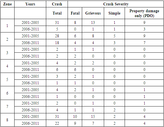
The road traffic accident database obtained from ARI was huge, which was further analyzed using the MAAP5 software. One example of only the accident severity data is shown in Table 2.Table 2. Accident Severity Data
 |
| |
|
5.2. Condition and Collision Diagram
Using the predicted day-time accident values, combined collision and condition diagrams were prepared in order to get a better understanding of the actual field situation. These diagrams included at least 100 meter of school zone area in all sides. Such a combined collision and condition diagram for school zone #1 is shown in Figure 2.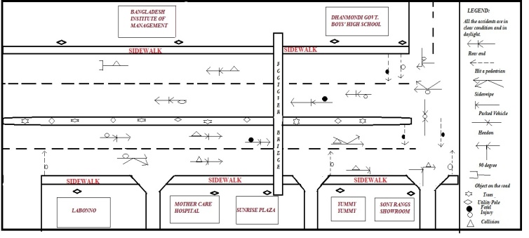 | Figure 2. Combined Condition and Collision Diagram for School Zone #1 |
5.3. Information Obtained from Field
The field data provided detail information about the road safety-related risk factors. As noted, the field data of the eight school zones were analyzed with the help of a matrix developed in this study. As an example, the information obtained from School Zone 3 is shown in Table 3.Table 3. Information on St. Paul’s Mission School of Zone 3
 |
| |
|
Available data identified ‘hit pedestrian’ as the leading accident type in the study area, out of which overall 45% cases involve fatality and 31% involve non-fatal injury. Common accident types were rear end collision (16.5%), head on collision (13.2%) and overturning (9.3%). With these percentages, the analysis came up with accidents of each collision type. Using the predicted day-time accident values, combined collision and condition diagrams were prepared. As a standard practice, these diagrams included at least 100 meter of school zone area in all sides (Hoque et al., 2007). As designed for all school zones, each risk factor was assigned a “Low”, “Medium” or “High” rating with a corresponding index value of 1, 2 or 3, respectively, and the total “Beneficial point” was subtracted from the total “Adverse point” to obtain the “Overall Impact Value”. Table 4 shows an example of impact calculation matrix that was used for the School Zone #2. The cumulative beneficial point was 6 and adverse point was 32, resulting in an overall impact value of 26 (= 32 – 6).Table 4. Impact of Risk Factors for School Zone 2 (St. Paul’s Mission School)
 |
| |
|
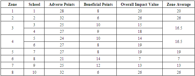
The details of the impact values of the ten schools and corresponding eight zones are presented in Table 5, while the overall impact values of the eight school zones evaluated in this study are graphically shown in Figure 3.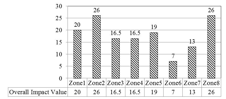 | Figure 3. Overall Impact Values of School Zones |
Table 5. Overall Impact Values
 |
| |
|
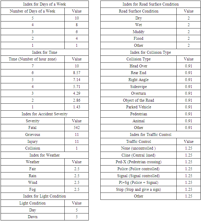
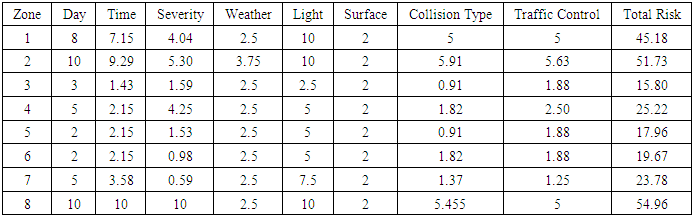
To further analyze the accident data from 2001 to 2011, a new accident index system was introduced by using a matrix (see Table 6). Note that for “severity”, the EPDO (Equivalent Property Damage Only) Method was followed (AASHTO, 2010). The risk index values were obtained by dividing exact number of accident/condition with highest number of accident/condition, then multiplying with 10. The cumulative risk index values were inserted in a “Risk Index Matrix” as shown in Table 7.Table 6. Accident Index System for Data Analysis (example for days of week and surface condition)
 |
| |
|
Table 7. Risk Index Matrix (Averaged for 2001-2011)
 |
| |
|
It was found that the field data match with the existing data. The reason behind that was the risk factors chosen was in fact representing the road safety status of the school zones. The findings indicate three school zones are in “high risk” category, which is about 37.5% of the total school zones. These high risk school zones are: (i) Dhanmondi Government Boys High School, (ii) St. Paul Mission School, and (iii) Dhaka City College. The least risk zones were the Sunbeams School and the Oxford International School. The average total risk index values of the school zones evaluated in this study are shown in Figure 4.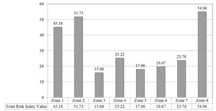 | Figure 4. Total Risk Index Values of School Zones |
6. Conclusions
The matrices and tables developed in the study were made by taking qualitative data related to school zone traffic safety obtained from 10 schools, which covered 8 major school zones of Dhaka – the capital city of Bangladesh. The qualitative data have been converted into quantitative data. The process can be modified easily to insert more future data. An index system has been developed to ensure flawless data conversion. The survey data for each school zone and school played a vital role in the research. Matrices from existing data were developed to ensure accuracy of the study. All these matrices were compared with each other to measure the accuracy of risk and impact of each zone, which led the study to create a methodology for developing a risk rating system. By using that system, the study could identify high risk zone as well as low risk zone. It was found from the study that three school zones were in high risk, three school zones were close to high risk and the rest two were moderately low compared to the others. With proper field survey, accurate result can be obtained for any selected area in Dhaka city. It is taken into account that accurate result is obtained when compared to the existing data and modified survey data and it is ensured that they match with each other. This research study has finally developed a School Zone Road Safety Risk Rating System, which is an innovative way to identify the road safety situation for school students of city areas.
References
| [1] | AASHTO (2010). Highway Safety Manual. American Association of State Highway and Transportation Officials (AASHTO), Washington, DC, USA. |
| [2] | Ahmed, B. (2012). Traffic Accident Study in Dhaka City (2007-2011). Project Report. Clean Air and Sustainable Environment (CASE) Project. Dhaka South City Corporation (DSCC), Dhaka North City Corporation (DNCC) and the World Bank. June 7, 2012. |
| [3] | Ahsan, M. H. (2012). Road Safety in Bangladesh: Key Issues and Countermeasures. The Daily Star newspaper. Monthly “Forum”, Volume 6, Issue 07, July 2012. |
| [4] | Anjuman, T., C. K. A. Siddiqui (2007). The road safety situation for children in Bangladesh. Proceedings of the ACRS (Australasian College of Road Safety) Conference on Infants, Children and Young People and Road Safety. Sydney, Australia. August 2-3, 2007. |
| [5] | Baguley, C. J. (1994), TRRL's Microcomputer Accident Analysis Package (MAAP): A Standard for SARTTO Countries, Transport Research Laboratory, TRID Accession No. 00646854, Washington, DC, USA. |
| [6] | Bangladesh Sangbad Sangstha (2016). Staff Correspondent. Accident kills brilliant school student, road blocked. January 16, 2016. |
| [7] | Bdnews 24 (2016). Staff Correspondent. School-boy killed in road accident in Dhaka. January 27, 2016. |
| [8] | Dhaka Tribune (2017). Local Correspondent. Schoolgirl killed in Dhaka road accident. September 12, 2017. |
| [9] | Hoque, M., S. S. M. Mahmud, A. Siddiqui, and C. Kawsar (2007). Road safety in Bangladesh and some recent advances. Swedish National Road and Transport Research Institute (VTI). Accession Number: 01114774, November 18, 2008. Presented at Road Safety on Four Continents: 14th International Conference. Bangkok, Thailand, November 14-16, 2007. |
| [10] | Jaki, A. M. (2016). Road traffic accident: Leading cause of child death in Bangladesh. Daily Asian Age newspaper. October 19, 2016. |
| [11] | Rahman, A., F. Rahman, S. Shafinaz, and M. Linnan (2005). Bangladesh Health and Injury Survey: Report on Children. (2005). UNICEF, Bangladesh. |
| [12] | The Daily Star (2010). Staff Correspondent. KG student run over. February 4, 2010. |
| [13] | The Daily Star (2016). Local Correspondent. Road crash: 2 schoolgirls killed in 8 hrs. in Dhaka. January 16, 2016. |
| [14] | United Nations International Children’s Emergency Fund (UNICEF), Bangladesh (2003). Bangladesh Health and Injury Survey: Key Findings on Child Injuries. |
| [15] | United Nations International Children’s Emergency Fund (UNICEF), Bangladesh (2008). Prevention of Child Injury in Bangladesh. |

 Abstract
 Reference
 Full-Text PDF
 Full-text HTML