-
Paper Information
- Paper Submission
-
Journal Information
- About This Journal
- Editorial Board
- Current Issue
- Archive
- Author Guidelines
- Contact Us
International Journal of Traffic and Transportation Engineering
p-ISSN: 2325-0062 e-ISSN: 2325-0070
2018; 7(3): 63-69
doi:10.5923/j.ijtte.20180703.03

Intelligent Recommendation Module for Emergency Vehicles
 Abstract
 Reference
 Full-Text PDF
 Full-text HTML
Emad I. Abdul Kareem, Farah Younus Safar
Computer Science, Mustansiriyah University, Iraq
Correspondence to: Emad I. Abdul Kareem, Computer Science, Mustansiriyah University, Iraq.
| Email: |  |
Copyright © 2018 The Author(s). Published by Scientific & Academic Publishing.
This work is licensed under the Creative Commons Attribution International License (CC BY).
http://creativecommons.org/licenses/by/4.0/

The traffic congestion and long queuing issues are avoiding emergency vehicles to pass. In addition to increasing number of cars in the street, lack of adequate infrastructure, lack of economic situation in some nations, weather condition, and the purpose of a city can have an impact to the traffic flow. Those reasons may interfere with the enactment of emergency vehicles traveling to their destinations scenes. This paper aim to enhanced moving the emergency vehicles by intelligent recommendation module for emergency vehicles with monitor module and simulating annealing algorithm to provide the appropriate route for emergency vehicles travel along the optimal road it is not necessary to be the shortest one from root node to the goal client. The result shows that the proposed module able to find the optimal path from 5.11s to 8.24s depends on the number of traffic intersections.
Keywords: Transportation system, Traffic congestion, Emergency vehicles, Simulated annealing algorithm
Cite this paper: Emad I. Abdul Kareem, Farah Younus Safar, Intelligent Recommendation Module for Emergency Vehicles, International Journal of Traffic and Transportation Engineering, Vol. 7 No. 3, 2018, pp. 63-69. doi: 10.5923/j.ijtte.20180703.03.
Article Outline
1. Introduction
- The importance and scope of emergency vehicle services have been grown over the past decade. Traffic jam may prevent the ability of emergency vehicle services to reach destination in fast and at the earliest time. If there is a congestion in the shortest path the speed of the emergency vehicles must decrease which lead to increase the time of arrival. For those reasons the shortest path does no t always lead to optimal path, emergency vehicles need to well-planned recommendation services to determine the appropriate emergency vehicles and route before moving the emergency vehicle to destination scene. Researcher introduced solution for emergency vehicles traveler by using other optimization algorithms such as genetic algorithm optimization, Ant colony algorithms. In this work the simulated annealing has been used due to its ability to provide perfect solutions for many problems [1] [2].The module should be able to integrate with monitoring module, this monitoring module will be provided the street conditions (crowded, normal, empty). Mapping the intersection with its corresponding streets distance and evaluate the proposed module with different numbers of intersections and streets taking time into account. The result shows that the proposed module able to find the optimal path of each map with its elapsed time such as in map with 12 traffic intersections is 5.11 seconds, while in 30 traffic intersections is 8.24 seconds.
2. Related Works
- (Jyun-Min Dai et al. 2017) their objective is to find the most comfortable route, which is not necessarily mean to be the shortest one, they prepare an early research on the path recommendation system based on street view images. It consists of three fundamental functions. (1) Data collection (2) Road surface extraction (3) Road surface identification, they utilized GSV (google view image) [3].(Xiaoyi Fan et al. 2017) they supply an overview of past and present road navigation technologies. They use crowdsourced human intelligence in navigation. Then present a design of Crowd-Navi, a workable crowdsourced navigation system, as a appendix to the digital map services Crowd Navi is to be installed on mobile devices, the app will run in the background, monitoring the moving path of a car using GPS and periodically reporting the location information to a backend server. The server accordingly maintains a database of the path information of the app users [4].(Hazar Hamdi et al. 2017) and Jalel Akaichi they introduced an algorithm based on ant colony optimization algorithm to find the best route that minimizes the time while taking into consideration the status of problems that can appear each time such as traffics, catastrophes natural, etc. they solve various type of problems such as the traveling salesman. Their solution to find the fastest path that may not be the shortest one [5].(Muhammad Usman Shahid Khan et al. 2015) they introduced an emergency evacuation service, termed the MacroServ that recommends the evacuees to better paths towards safe locations during a disaster. The evacuees are looking for routes that are safe and have less congestion. They utilized probability distributions to model the real-life stochastic behaviors of evacuees during emergency scenarios. The MacroServ which is capable of implementing real time simulation of dynamic large scale transposition networks. They use parallel computing to achieve the required scale, size and speed of the computation [6].(Richard McCormack et al. 2014) They introduced the optimization of EMS vehicle fleet allocation and base station location they use the genetic algorithm (GA) with an integrated EMS simulation model and introduced the optimization heuristic and objective function used in conjunction with the simulation model [7].(Long Liu et al. 2014) They developed a novel route recommendation system to make self-drive tourists with real-time personalized route recommendations This will help to reduce the congestion and queuing time in tourist hotspots, their research is relevant to a personalized route recommendation system for self-drive tourists, vehicle to vehicle communication systems and real time traffic information [8].(Yi Liu et al. 2014). They introduced Emergency medical service (EMS) providers participating in vehicle crash-induced incident management aims to supply a wide and efficient coverage as possible to meet the require for accident responses effectively; however, the design and provision of efficient and cost-effective services are tough issues faced by emergency management authorities. They present a double standard model (DSM), along with a genetic algorithm (GA) for assigning EMS fleet from vehicle locations to intersection vehicle crash sites [9].(Kanchala Sudtachata et al. 2014) They present recommendations for multiple-unit dispatch to multiple call priorities based on simulation optimization and heuristics [10].
3. Intelligent Transportation Technology (ITS)
- The transportation system is a system of moving people and goods. It consists of vehicles that move the objects or traffics, the way or the links and nodes that make the network. ITS technology is the application of information technology that is used to develop the efficiency of transportation systems, solve the problems of traffics, enhancement of safety and mobility for transportation where it decreases the environmental impact of transportation, It depends on a wide range of technologies and functions such as: camera system, digital mapping, communication systems, data acquisition and exchange, detection and classification, artificial vision and In-vehicle system [11].
4. Optimization Technique
- Optimization is a process of determining the optimal answer. [12] Every problem in life, science, economic and engineering can be formulated as optimization, some problems that are simple can solve using traditional optimization that their analysis based on mathematical, most of problems is very hard to solve so these hard problems can solve it using computing inspired by nature. There are more biologically inspired methods such as particle swarm optimization, ant colony optimization and immune algorithms. And there are many other optimization algorithms include physical laws, chemical reaction, biological phenomena, social behavior, animal thinking.
4.1. Simulated Annealing Algorithm
- Simulated annealing is a metaheuristic algorithm that used to obtain the optimal solution and to deal with optimization (see algorithm 1). It is single–based solution. Simulated annealing inspired by physical phenomena which is annealed in metallurgy [12]. It can run away from local optima. Its implementation and convergence properties are easy, its use of hill-climbing moves to escape local optima have made it a popular technique It is applied using to address discrete, and to a minimum range, continuous optimization problems. Annealing referred to as heat material such as metal, glass or crystal in its melting point and then cooling it very slowly until lead to crystallized solid state in perfect crystalline structure [13]. The opposite of annealing process is quenching process which is quickly cooling the temperature of the material. This process can lead to an amorphous structure. The local minimum in energy referred to metastable state [14].
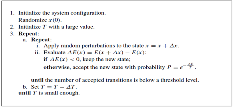 | Algorithm 1. Simulated Annealing Algorithm (SA) |
5. The Proposed Module
- A proposed module is shown in figure (1). The proposed module should be integrated with monitor module which is used to provide the status of streets (crowded, not-crowded) in each street. This monitor module incorporates with the distance of the street and by using an intelligent physical technique, which it simulated annealing algorithm will leads together to introduce recommendation street path for emergency vehicle. For street distance, it can be obtained from a map, firstly prepare a map street distance that needs to be found. The Google map distance has a simple tool that use to draw lines on a map and measure it distances for each street between a pair of traffic intersection.
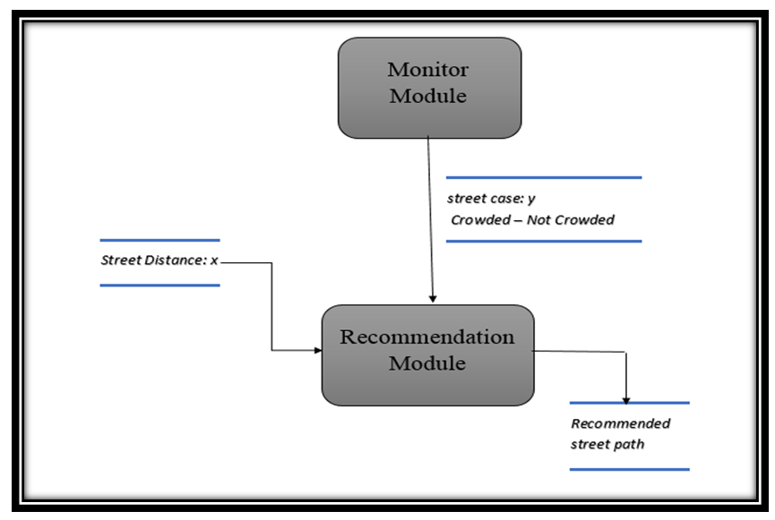 | Figure (1). Framework of the proposed intelligent recommendation module |
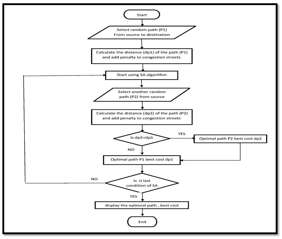 | Figure (2). Flowchart for the first proposed recommendation module from one source to one destination |
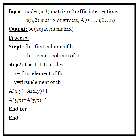 | Algorithm 2. Calculate of adjacent Matrix |
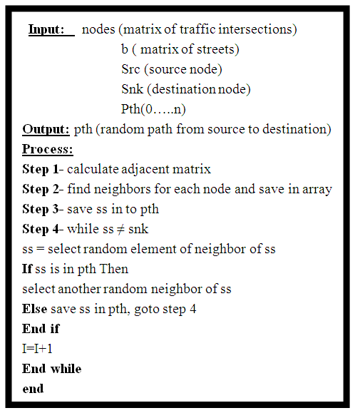 | Algorithm 3. Produce random path from source to destination |
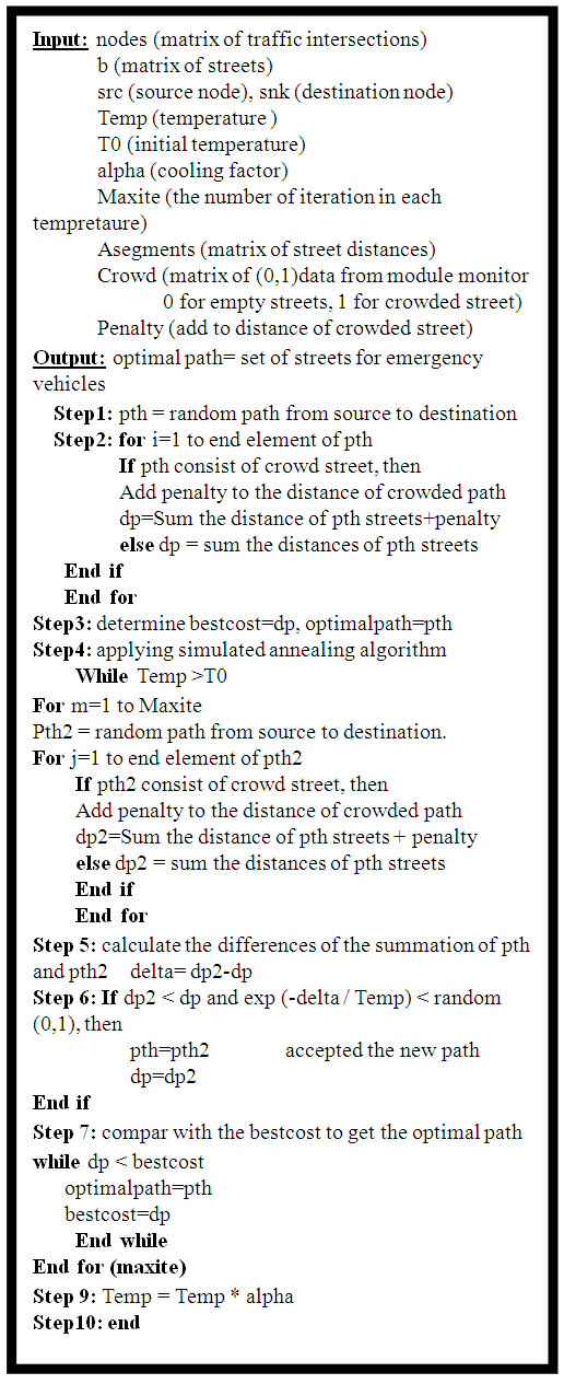 | Algorithm 4. Find the optimal path from one source to one destination scene |
6. Result and Discussion
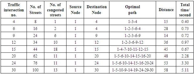
- The algorithm of intelligent recommendation for emergency from one source node to destination node has been evaluated using eight maps to determine the optimal path from different source nodes to destination nodes, start from 4 traffics intersection up to 30 traffic intersection taking time into account. Maps implementation consist of 4 – 30 traffic intersections, the optimal path in these maps, if a vehicle move from source node to destination node, the track path will be chosen with optimal path which may be are not the shortest path.Figure (3) illustrates the time process for the optimal path in the eight maps from 4 to 30 traffic intersections until 100 streets. That the process time will be increased as soon as the number of street increase too. Table (3) represents eight maps with random number of crowded streets, the source node 1, and different values of destination nodes, different optimal paths, distances and the total time for each traffic intersection. The time is different for each traffic intersection. The total time for the map of 4 traffic intersection is 0.4 second while the total time for the map of 30 traffic intersection is 5.11 second. The time will be increased if the number of traffic intersections will be increased. In contrast the time will be decreased if the number of traffic intersection.
|
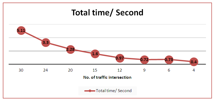 | Figure (3). Performance criteria values of all maps |
7. Conclusions
- The proposed module is recommended the emergency vehicle for tracking the street with less number of crowded streets. The modified simulated annealing has been capable to determine optimal paths for more than one emergency vehicle on the same map and define the optimal vehicle which is must move to the destination node passing less crowded streets (as much as it can). The proposed module is integrated with monitoring module, this monitoring module used to provide the street condition. The intersection with its streets is mapped in different number of traffic intersection with a random number of crowded streets in each map. Eight maps have been utilized with one source node to single destination node test. The spent time for map of 4 traffic intersection is 0.40 seconds. While the spent time for map of 30 traffic intersection is 5.11 seconds. The spent time depends on the destination node place. If the destination node is near to the source vehicle, the time spend is smaller than the far from the source node. The large number of traffic intersection nodes takes more processing time than the small number of intersection nodes.