-
Paper Information
- Paper Submission
-
Journal Information
- About This Journal
- Editorial Board
- Current Issue
- Archive
- Author Guidelines
- Contact Us
International Journal of Networks and Communications
p-ISSN: 2168-4936 e-ISSN: 2168-4944
2018; 8(5): 123-128
doi:10.5923/j.ijnc.20180805.01

A Review of Communications Satellite by Focusing on ‘Bangabandhu Satellite-1’, the First GEO Communications Satellite of Bangladesh
 Abstract
 Reference
 Full-Text PDF
 Full-text HTML
S. M. Rezaul Karim1, Shadman Sakib1, Md. Turiqul Islam1, F. A. Sabbir Ahamed2
1Department of EEE, International University of Business Agriculture and Technology, Dhaka, Bangladesh
2Department of Physics, International University of Business Agriculture and Technology, Dhaka, Bangladesh
Correspondence to: Shadman Sakib, Department of EEE, International University of Business Agriculture and Technology, Dhaka, Bangladesh.
| Email: |  |
Copyright © 2018 The Author(s). Published by Scientific & Academic Publishing.
This work is licensed under the Creative Commons Attribution International License (CC BY).
http://creativecommons.org/licenses/by/4.0/

This paper has two major parts. In the first part, a brief review of satellite communication is shown by mentioning types of orbit, frequency bands and a block diagram of satellite communication. Here, the block diagram reflects a general view of uplink, transponder and downlink section of a communication satellite. Description of each section has been given by explaining the function of every unit. The second part focuses solely on ‘Bangabandhu Satellite-1’, the first GEO satellite of Bangladesh, analyzing its costs, specifications and ground control stations. The footprint of the satellite including its primary and secondary coverage areas is shown in a figure. Finally, the impacts and applications of the satellite are given.
Keywords: Satellite communication, Uplink, Transponder, Downlink, GEO, Frequency bands, Bangabandhu Satellite-1, ground control station, Footprint, Coverage areas, DTH, VSAT
Cite this paper: S. M. Rezaul Karim, Shadman Sakib, Md. Turiqul Islam, F. A. Sabbir Ahamed, A Review of Communications Satellite by Focusing on ‘Bangabandhu Satellite-1’, the First GEO Communications Satellite of Bangladesh, International Journal of Networks and Communications, Vol. 8 No. 5, 2018, pp. 123-128. doi: 10.5923/j.ijnc.20180805.01.
Article Outline
1. Introduction
- The twenty-first century is an era of communication technology. People all over the globe can connect with others using various forms of communication technology. Satellite communication has opened a full window in the telecommunication sector. It offers advantages like global availability, superior reliability, better performance, immediacy, and scalability. Communications satellites are used to connect people in remote areas where cellular and fiber optic networks are not available, navigate ships and aircrafts, provide weather updates and most importantly enable DTH and VSAT services. A promising country like Bangladesh has launched its first ever satellite with a vision to open the new dimension of possibility in its telecommunication sector. Satellite network will play a vital role in ensuring uninterrupted telecommunication services in Bangladesh by reducing its dependency on other nations even in an emergency situation like natural disasters [1].
2. Communications Satellite Basics
- A communications satellite is a wireless communication device in Earth’s orbit that uses a transponder to send and receive data from Earth. Transponder refers cumulatively to the terms Transmitter and Responder. The communications satellite is primarily used to redirect communication data from one earth-based communication station to another station which are called uplink and downlink section respectively. Generally, a communications satellite works when it receives data from terrestrial stations in the form of electromagnetic waves (radio frequency). The data is usually sent via large satellite antennas form uplink section. Based on the intended destination, the communications satellite retransmits the waves to the corresponding downlink station. The footprint of a communications satellite is the ground area in which a broadcast signal from a particular satellite can be received. The location of the satellite in its orbit, the shape, and size of the beam produced by its transponder and the distance from the earth are the criteria on which the size of the footprint depends.The ability to simultaneously link all users on the earth’s surface, thereby providing distance insensitive point to multipoint communications is the unique features of communications satellites [2]. Communication satellite can connect people from different locations from anywhere on earth via space in a number of ways like the ground to ground link (a), crossed link (b) and ground to relay platform (c) shown in Figure-1 respectively [3]. Their combination makes the hybrid link.
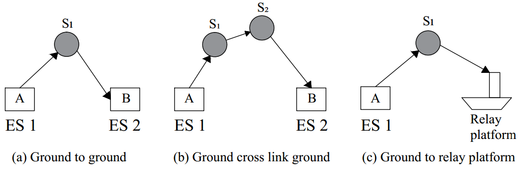 | Figure 1. Link of connections in satellite communication |
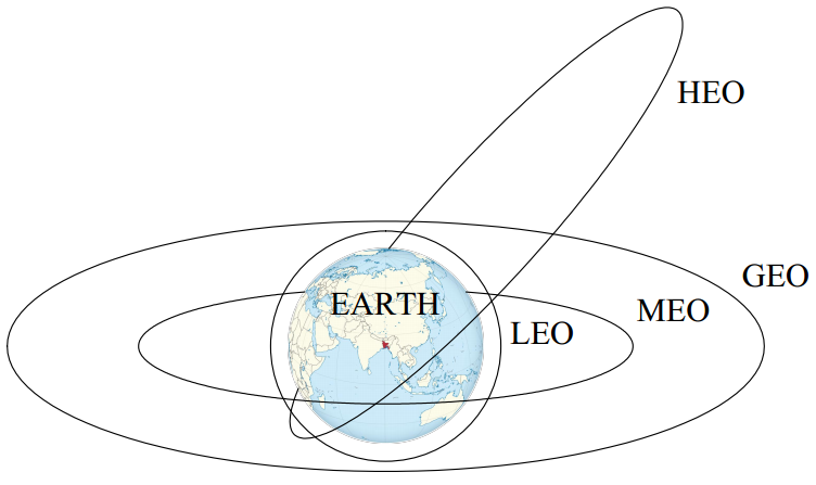
3. Types of Satellite Orbit
- Depending on the distance from the earth orbit can be categorized into several categories like LEO, MEO, GEO, and HEO.Low Earth Orbit (LEO) satellites orbit from 1000-5000km above the earth, take approximately 1.5 hrs for a full orbit and only cover a portion of the earth’s surface, therefore requiring a network or constellation of 50 to 200 satellites to provide global, continuous coverage. Due to the proximity to Earth, LEO satellites have lower latency and require less amplification for transmission. LEO satellites have a short lifetime of 5 to 7 years [4].Medium Earth Orbit (MEO) satellites are located above LEO and below GEO satellites which is about 10000km to 15000 km from earth. MEO satellite typically travels in an elliptical orbit over the North and South Pole or in an equatorial orbit and take approximately 6 hrs for a full orbit. These satellites are traditionally used for GPS navigation systems and are sometimes used by satellite operators for voice and data communications. MEO satellites require a constellation of satellites to provide continuous coverage [5, 6].
 | Figure 2. The arrangement of orbits surrounding the earth |
 | Figure 3. The orientation of a geosynchronous orbit |
4. Satellite Communication System
- The satellite communication can be divided into three sections:1. Uplink Section (Ground Station)2. Transponder (Airborne Satellite)3. Downlink Section (Ground Station)The uplink section consists of following units– • Intermediate Frequency (IF) Modulator• Band Pass Filter (BPF)• Up Converter (Mixer, BPF & Uplink Frequency Microwave Generator)• High Power Amplifier (HPA)• Transmitting (Tx) AntennaThe signal which user wants to send is called as Baseband Signal. It is feed to Intermediate Frequency (IF) Modulator who converts baseband frequency to intermediate frequency through different types of modulation process like ASK, FSK and, PSK according to the requirement. The output IF is passed through a Band Pass Filter (BPF) for cutting off unnecessary frequency components. The IF is sent to UP-Converter where IF range (MHz) is increased to Radio Frequency (RF) range (GHz) with the help of Mixer & Uplink Frequency Microwave Generator. Here, Radio Frequency (RF) = (LO + IF) and Intermediate Frequency (IF) = (LO – RF). Here, LO is Local Oscillator Frequency. There is another BPF for the RF signal to become more accurate uplink frequency. Finally, the RF is passed through a High Power Amplifier (HPA) for gaining enough strength to travel a long distance before it is radiated through transmission (Tx) antenna.Transponder consists of the following subsections– • Receiving (Rx) Antenna• Band Pass Filter (BPF)• Low Noise Amplifier (LNA)• Frequency Translator • Low Power Amplifier (LPA)• Transmitting (Tx) AntennaTransponder implies to Transmitter + Responder. The transmitted frequency from the uplink section and received frequency at the transponder by a receiving (Rx) antenna are the same. Noise filtering is performed by a Band Pass Filter (BPF). Then the RF signal is sent to the Low Noise Amplifier (LNA), a tunnel diode, which amplifies the signal but keeps noise level very low. To get some specific advantages (e.g., small antenna size and less power consumption) downlink frequency is usually kept 2 GHz less than uplink frequency. Frequency Translator performs the frequency conversion with the help of Mixer & Microwave Shift Oscillator. Again a BPF is used to get more accurate downlink frequency. Finally, the downlink frequency is passed through a Low Power Amplifier (LPA) for gaining strength to come back to earth before radiating through transponder’s transmission (Tx) antenna.Downlink section consists of following units– • Receiving (Rx) Antenna• Band Pass Filter (BPF)• Low Noise Amplifier (LNA)• Down Converter (Mixer, BPF & Downlink Frequency Microwave Generator)• Intermediate Frequency (IF) DemodulatorThe transmitted frequency from the transponder and received frequency at the receiving antenna are the same. A Band Pass Filter (BPF) cuts off the unnecessary frequency components. Then the RF signal is sent to the Low Noise Amplifier (LNA) for amplification. Then the RF signal is feed to Down-Converter where RF range (GHz) is decreased to IF range (MHz) with the help of Mixer & Downlink Frequency Microwave Generator. Intermediate Frequency (IF) Demodulator converts intermediate frequency to baseband frequency. This baseband signal is the signal which was sent via transponder by the user from the uplink section.
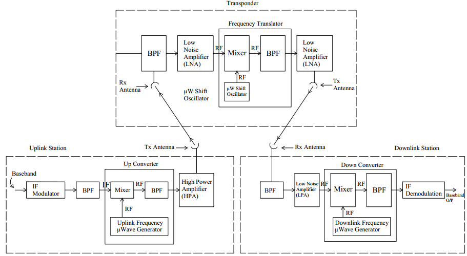 | Figure 4. The complete block diagram of satellite communication system |
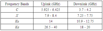
5. Frequency Bands
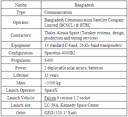
- There are many frequency bands for communication and military satellites. The ‘Bangabandhu Satellite-1’ is fitted with 26 Ku-Band and 14 C-Band transponders.
|
6. Specifications and Financing of ‘Bangabandhu Satellite -1’
- Bangabandhu Satellite -1(BS-1) satellite, the first Bangladeshi geostationary communications satellite, is launched on May 10, 2018, for a 15-year expected lifetime. Bangladesh becomes the 57th member of the exclusive club of the satellite owning country. BTRC also plans to launch follow-on series of BD-2 and BD-3 satellites in phases. The satellite will have 40 transponders with a capacity of approximately 1,600 megahertz (36 MHz each). BS-1 is stationed at an orbital slot at longitude 119.1° east. The orbital slot was bought from Russian satellite company “Intersputnik” for $28 million in the year 2017. BTRC signed a $248 million deal with Thales Alenia Space to manufacture and launch Bangabandhu-1. Two earth stations have been set up at Joydebpur in Gazipur and Betbunia in Rangamati under this project. On September 9, 2016, an agreement of 157 million Euro (equivalent to BDT 1,400 crore) was signed with Hong Kong and Shanghai Banking Corporation (HSBC) for the financing of the project [1, 10, 12]. The total cost for this project is BDT 2,765 crore.
|
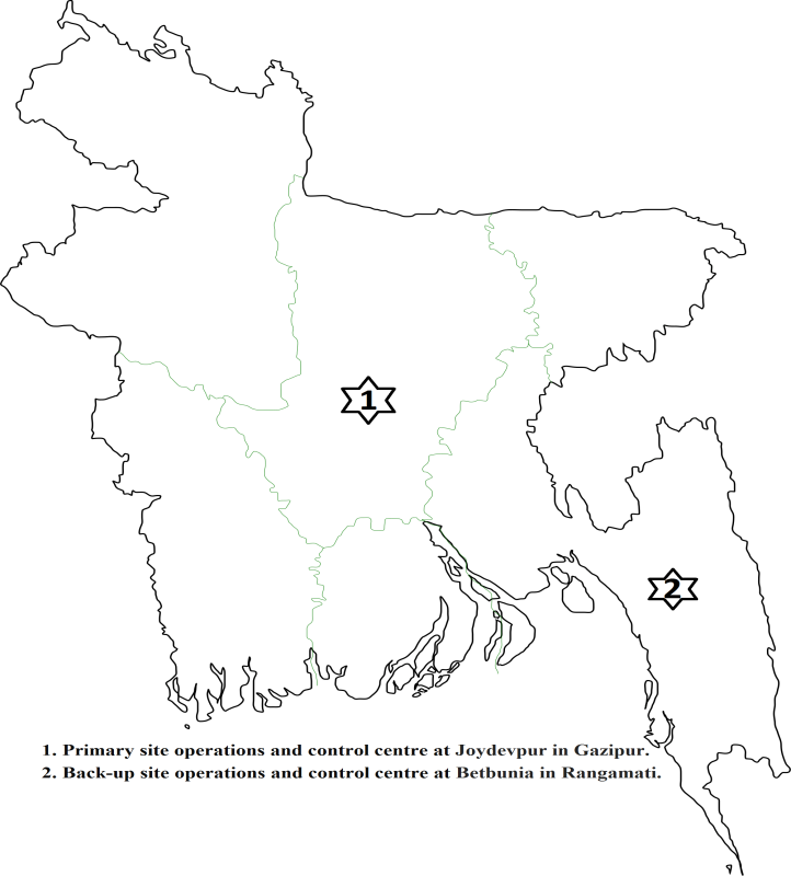
7. Ground Control Stations of BS-1
- There are two ground stations for BS-1 operation and control as a primary and a backup site. The primary and backup sites are located at Joydevpur in Gazipur and Betbunia in Rangamati respectively [1].
 | Figure 5. The position of ground control stations in Bangladesh |
8. Coverage Areas of ‘Bangabandhu-1’ Satellite
- The satellite’s coverage zone encompasses Bangladesh and the surrounding region offering the capacity in Ku-band over Bangladesh and its territorial waters of the Bay of Bengal, India, Nepal, Bhutan, Sri Lanka, Philippines, and Indonesia; it also provides capacity in C-Band over the whole region [1].
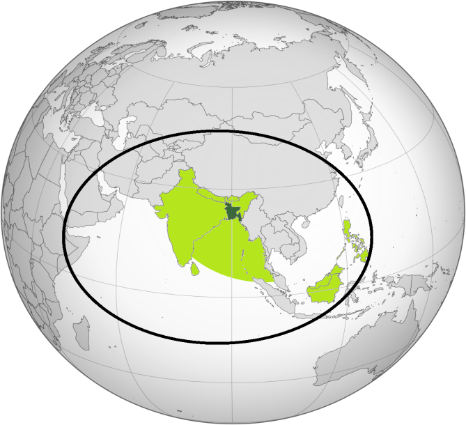 | Figure 6. Coverage area (PSA and SSA) of BS-1 across the globe |
9. Services and Impacts of BS-1
- BS-1 will bring enormous betterment to the current service of the nation's television, telephone and internet service. Bangladesh spends almost US$ 14 million a year to meet its satellite connectivity needs by renting bandwidth from operators of different countries. Having launched BS-1, Bangladesh will get the access to 40 transponders. 20 transponders are reserved for Bangladesh while the rest is rented out. According to Bangladesh Communication Satellite Company Limited (BCSCL), BS-1 will provide a wide range of services [11] such as: • Direct To Home (DTH): It includes service consisting of multiplexed digital television, radio, and associated data direct to tiny Ku-band antennas anywhere in the satellite’s footprint [13]. • Video Distribution: The users of the video distribution service are likely to be broadcasters distributing their content services to intermediaries like cable TV network operators, or re-broadcasters like DTH Operators in other countries. This service can be received to medium-sized C-band antennas anywhere in the coverage area.• VSAT Private Networks: With VSAT private network service any government or non-government organization can install their secured network using both C and Ku band antennas [14]. • Broadband: Ku-band broadband service will be provided by Satellite Service Providers (SSP) and Internet Service Providers (ISP). They allow end-user (individual, organization, corporation or government) to access the high-speed internet remotely.• Communications Trunks: Generally, Telco’s and GSM operators use communication trunks services. It will provide uninterrupted telecommunication service in remote areas using both C and Ku band antennas within the satellite’s footprint.• Weather Forecasting: Predictions of natural disasters like flood, hurricanes, and cyclones will be made by analyzing satellite images. Search and rescue under soil or water, many mining detections (oil, natural gas) will be possible.
10. Conclusions
- This paper has presented an overview of communication satellite where the Bangabandhu-1 satellite has been taken as an example. A simple explanation of satellite communication has been given with the help of a block diagram. It appears that BS-1 will enable a dramatic development in the current telecommunication and internet connectivity of the country as well as weather forecasting. BS-1 has added a new pace to the country’s IT and economy for establishing digital Bangladesh. Next paper will provide a relative comparison between two neighboring satellites BS-1 and GSAT-9.