-
Paper Information
- Paper Submission
-
Journal Information
- About This Journal
- Editorial Board
- Current Issue
- Archive
- Author Guidelines
- Contact Us
International Journal of Genetic Engineering
p-ISSN: 2167-7239 e-ISSN: 2167-7220
2024; 12(6): 141-145
doi:10.5923/j.ijge.20241206.15
Received: Dec. 3, 2024; Accepted: Dec. 26, 2024; Published: Dec. 31, 2024

Mechanical Composition and Salinity Level of the Soils Under Study (A Case Study of Besharyk District, Fergana Region)
 Abstract
 Reference
 Full-Text PDF
 Full-text HTML
Ruzimatova Sevara Erkinovna1, Makhkamova Dilafruz Yuldashevna2
1PhD Student at National University of Uzbekistan named after Mirzo Ulugbek
2Associate Professor at National University of Uzbekistan named after Mirzo Ulugbek, PhD in BS
Correspondence to: Ruzimatova Sevara Erkinovna, PhD Student at National University of Uzbekistan named after Mirzo Ulugbek.
| Email: |  |
Copyright © 2024 The Author(s). Published by Scientific & Academic Publishing.
This work is licensed under the Creative Commons Attribution International License (CC BY).
http://creativecommons.org/licenses/by/4.0/

This article examines the mechanical composition and salinization type and degree of irrigated meadow soils in Besharyk district, Fergana region. Based on the findings, this soil subtype is predominantly identified as low-saline. The mechanical composition of the studied soils varies from light, medium, and heavy loamy textures to sandy textures in certain areas. The article highlights the necessity of implementing specific agronomic measures in these soils.
Keywords: Irrigated meadow soils, Fertility, Mechanical composition, Physical sand, Physical clay, Fraction, Light loam, Water absorption, Dry residue, Salinization, Salinization type, Salinization degree, Leaching
Cite this paper: Ruzimatova Sevara Erkinovna, Makhkamova Dilafruz Yuldashevna, Mechanical Composition and Salinity Level of the Soils Under Study (A Case Study of Besharyk District, Fergana Region), International Journal of Genetic Engineering, Vol. 12 No. 6, 2024, pp. 141-145. doi: 10.5923/j.ijge.20241206.15.
1. Introduction
- Currently, over 50% of the 4304,32 thousand hectares of irrigated land in Uzbekistan are salinized to varying degrees. Scientific research and field experiments have demonstrated that cotton yields decrease by 20–30% on weakly saline soils, 40–60% on moderately saline soils, and up to 80% on heavily saline soils compared to non-saline fertile lands [2,10].Addressing these challenges necessitates a comprehensive study of the key characteristics and meliorative-ecological conditions of irrigated lands in the country. This involves conducting large-scale "salinized soil mapping" (salinity surveys) and developing scientifically grounded recommendations for mitigating soil salinity. Such measures include assessing the mechanical composition of soils, determining salinization degrees and chemical profiles (types), calculating the average salt reserves in the topsoil root zone (0–1m), and establishing appropriate leaching norms, schedules, and repetitions. Additionally, the implementation of agromeliorative measures tailored to these findings is among the most pressing issues today.On going research focuses on evaluating the water-physical, agrochemical, and meliorative properties of the land. Particular attention is given to designing agro-technical and agro-physical measures suited to the region's soil and climatic conditions. These efforts aim to improve, restore, and enhance soil fertility by leveraging advancements in science and practical applications.In the Besharyk district, 25308,0 hectares of land are irrigated, of which 13654,25 hectares (54%) are salinized to varying degrees. All factors that determine the salt regime of soils-such as groundwater level, mineralization, and chemical composition; soil solution salinity levels; irrigation regimes; quality of leaching and irrigation water; soil and substratum properties; condition of hydromeliorative systems; natural and artificial drainage; lithological-geomorphological and climatic conditions-are intricately interlinked. A change in any one factor invariably leads to significant alterations in others [6,7].For example, the failure of collector-drainage systems often results in a rise in the groundwater table and increased mineralization, which, in turn, triggers salt accumulation in soils and intensifies the processes of secondary salinization. Soil salinity varies based on the degree of salinization, the chemical composition of salts, the depth of the saline horizon, and the depth of groundwater. For the normal growth and development of cultivated plants, not only the total amount of salts in the soil but also their chemical composition plays a critical role. Consequently, determining salinity levels based on the chemical composition of salts is of utmost importance [1,3,9].The toxicity of salts largely depends on the specific ions they contain. In the irrigated agriculture of Central Asia, chloride salinization is often toxic to cultivated plants, with even 0.01% chloride content in the soil adversely affecting crops. In contrast, the toxic effects of sulfates in soil are typically observed when their concentration reaches 0,2–0,3%.The primary goal of creating soil salinity maps is to identify the causes of soil salinization, devise measures to prevent salinity, and provide recommendations for crop management and land reclamation practices.In Besharyk district, non-saline soils account for 11653,8 hectares, which constitutes 46,05% of the irrigated land. Slightly saline soils cover 8925,39 hectares, making up 35,27% of the irrigated area. These lands are considered satisfactory in terms of meliorative condition due to functional collector-drainage systems and ongoing leaching practices. The salinity type of these slightly saline soils is predominantly chloride-sulfate and sulfate, with a mechanical composition ranging from heavy to medium loam. Slightly saline soils are distributed across nearly all areas of the district [8].Moderately saline soils occupy 3388,8 hectares, equivalent to 13,39% of the district's irrigated land. The salinity type in these areas is also primarily chloride-sulfate and sulfate. The mechanical composition varies from heavy to medium and light loam. Similar to slightly saline soils, moderately saline soils are widespread throughout the district [4,5].Severely saline soils cover an area of 558,3 hectares, accounting for 2,21% of the irrigated lands in Besharyk district. The salinity type is predominantly chloride-sulfate and sulfate. These soils have a mechanical composition of heavy and medium loam. Severely saline soils are distributed across several areas, including Chimboy, Adirobod, Ropqon Telov, Besharyk ATS, Sobirtepa, Besharyk MTP, G. Rakhimov, N. Akhmedov, Marasulov, and Mazokirov regions [6].Extremely saline soils occupy 781,74 hectares, representing 3,09% of the district’s irrigated lands. Similar to severely saline soils, their salinity type is mainly chloride-sulfate and sulfate, and their mechanical composition is heavy and medium loam. These soils are confined to Chimboy, Besharyk ATS, Besharyk MTP, G. Rakhimov, N. Akhmedov, and Marasulov areas.In total, moderately, severely, and extremely saline soils in Besharyk district span 4728,9 hectares, constituting 18,7% of the total irrigated area and 34,6% of the total salinized area [6].
2. Research Methods
- The study was conducted on irrigated meadow soils in the CNBN and Agrotexservice areas of Besharyk district, Fergana region. Soil analyses were primarily carried out at the "Tuproqsifattahlil" State Unitary Enterprise laboratory. Key parameters analyzed included humus content, available phosphorus and potassium, water absorption, gypsum content, carbonate content, and total NPK levels.
3. Analysis and Results
- In the Fergana Valley, the primary source of water for irrigation agriculture is the Syr Darya River, which forms from the confluence of the Karadarya and Naryn rivers originating in the Fergana Ridge and Tien Shan Mountains. Water from the Syr Darya is distributed through the Northern Fergana, Katta Namangan, and Okhunboboev canals to irrigate both plains and foothill zones of the district. The mountain streams in the northern part of the region primarily feed on snowmelt and rainfall. The foothill slopes, formed from Quaternary deposits, serve as recharge zones for groundwater. The central part of the valley, stretching from east to west as the alluvial plains of Central Fergana, functions as a collection zone for groundwater and represents the final stage of groundwater formation.The hydrogeological conditions of the district are influenced by several factors: the depth and distribution of groundwater, geological-morphological structures, climate and surface water regimes, the development of irrigation networks and the presence of artificial underground drainage systems. As distance increases from irrigated zones, the depth of the groundwater table progressively increases. In areas where groundwater is shallow and stable, springs emerge, while the remaining water flows underground toward the alluvial plains of the Syr Darya River.In the ancient alluvial deposits of the Syr Darya region, groundwater originates from layered alluvial formations. Water rises due to underground pressure, with additional contributions from infiltration through irrigation systems and fields. Groundwater salinity generally ranges between 0,8–1,3 g/l but can reach up to 3 g/l in specific localized areas. The dominant ions in groundwater are sulfates (SO₄), with chloride ions being more prominent in lower parts of the plains. The salinity type is primarily sulfate, with some localized areas exhibiting chloride-sulfate or sulfate-chloride characteristics. A detailed summary of the findings is presented in (fig 1).
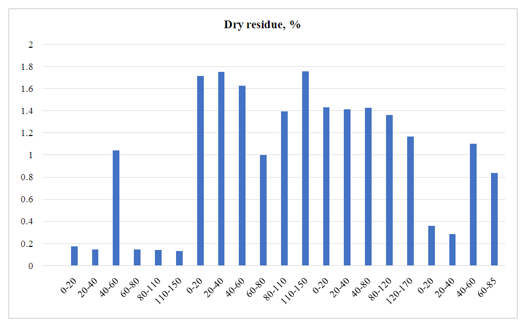 | Figure 1. Results of Water Absorption Analysis for Soils in the Agrotexservis and CNBN Areas of Besharyk District, Fergana Region |
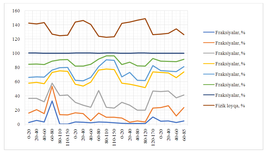 | Figure 2. The mechanical composition and physical clay content (%) of irrigated meadow soils in Besharyk district, Fergana region ("Ikromjon and Ayubhon " farm) |