-
Paper Information
- Paper Submission
-
Journal Information
- About This Journal
- Editorial Board
- Current Issue
- Archive
- Author Guidelines
- Contact Us
International Journal of Ecosystem
p-ISSN: 2165-8889 e-ISSN: 2165-8919
2021; 11(2): 31-45
doi:10.5923/j.ije.20211102.01
Received: Apr. 15, 2021; Accepted: May 21, 2021; Published: Jul. 26, 2021

Best Practices of Wetland Degradation Assessment and Restoration in the Semi-Arid Areas. Case Study of Uganda
 Abstract
 Reference
 Full-Text PDF
 Full-text HTML
Bernard Barasa 1, Moses Egaru 2, Polycarp M. Musimami 3, Paul M. Gudoyi 1, Gertrude Akello 1
1Department of Geography and Social Studies, Kyambogo University, Kyambogo University, Kampala, Uganda
2International Union for Conservation for Nature, Kampala, Uganda
3National Biodiversity Bank, Department of Environmental Management, Makerere University, Kampala, Uganda
Correspondence to: Gertrude Akello , Department of Geography and Social Studies, Kyambogo University, Kyambogo University, Kampala, Uganda.
| Email: |  |
Copyright © 2021 The Author(s). Published by Scientific & Academic Publishing.
This work is licensed under the Creative Commons Attribution International License (CC BY).
http://creativecommons.org/licenses/by/4.0/

Despite the harsh climate in the semi-arid areas of Uganda, anthropogenic activities continue to increase in many wetlands due to increasing human populations, causing incidences of degradation that require urgent restoration interventions. This study assessed wetland degradation and restoration in four wetland sites. To do this, the spatial- temporal extent and drivers of wetland use/cover changes and wetland degradation were determined, and the best steps, lessons, and principles of conducting wetland restoration were established. We used Sentinel-2 (2016-2019) and MODIS (2019) sensor images to estimate wetland changes and degradation status. Furthermore, focus group discussion, disaggregated by gender, was also conducted with representatives of the wetland user groups. The results revealed a reduction in the area under natural vegetation types compared to small-scale farming and built-up areas, between 2016 and 2019. This pattern was intensively driven by wetland cultivation, deforestation, occurrence of flash floods, and poor market linkages / price of yields. The consequential spatial extent of wetland degradation was generally high. To counteract this degradation, the best steps that ensued an effective wetland ecological restoration included conducting a baseline survey, stakeholder consultation, identification of reference sites, planning for future changes, implementation of restoration action plans, self-sustainability, and monitoring. During this exercise, the key lessons learned were to encourage equal participation of men and women, raise awareness, encourage restoration through income generation, and promote sustainability of restoration interventions. Therefore, if these practices are well implemented, they could increase the resilience of communities to climate change, enhance livelihood diversity and inform the processes of developing wetland management plans.
Keywords: Wetland degradation, Ecological restoration, Wetlands, Uganda
Cite this paper: Bernard Barasa , Moses Egaru , Polycarp M. Musimami , Paul M. Gudoyi , Gertrude Akello , Best Practices of Wetland Degradation Assessment and Restoration in the Semi-Arid Areas. Case Study of Uganda, International Journal of Ecosystem, Vol. 11 No. 2, 2021, pp. 31-45. doi: 10.5923/j.ije.20211102.01.
Article Outline
1. Introduction
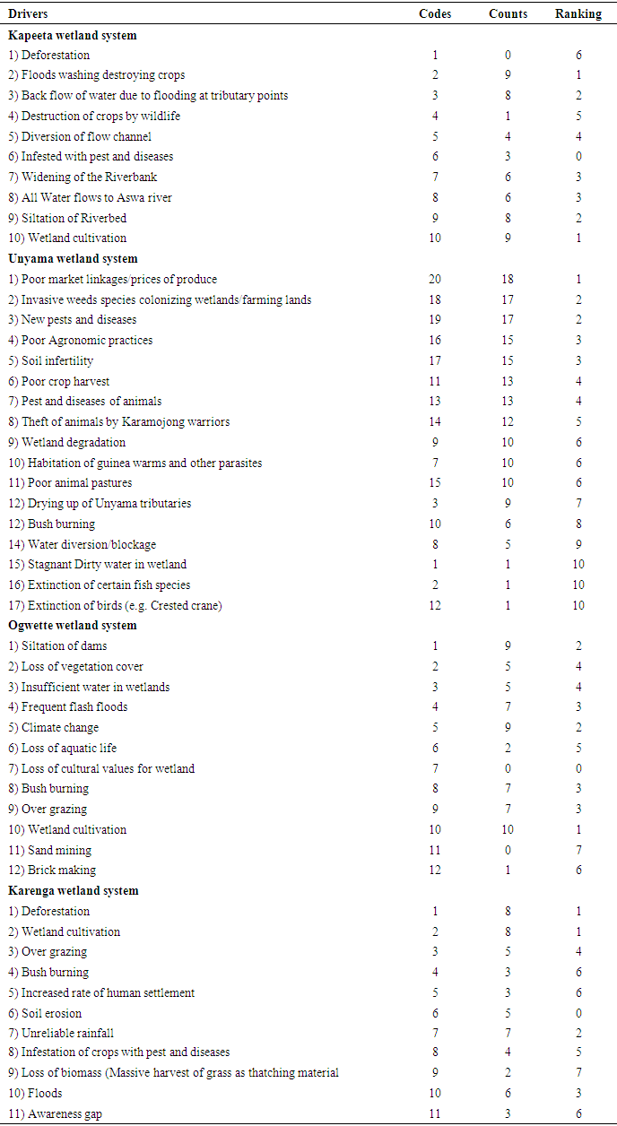
- The appearance of most wetlands in Africa can be described as lacustrine, riverine, coastal, palustrine, and valley wetlands, whether permanent or seasonal. The distinction is often based on vegetation type, morphology, and presence of fauna [14,27]. Wetlands provide valuable ecosystem goods and services that are vital for human existence, for example, regulation of flood waters, water purification, and habitat for fish and wildlife [9]. However, in most communities surrounding wetland ecosystems in the developing world, there is a general perception of wetlands as ‘wastelands’ that can often be put to more productive use, overlooking their ecological value [2,3]. As such, wetlands have been extensively exploited for paddy rice, sand mining, brick making, and establishment of industrial parks, all of which provide more economic benefits, but with impacts on natural resource protection necessary for ecosystem services provision to society. The result has been reduction in the area and integrity of the system, thus degradation [11]. Degradation here refers to the degeneration of wetland structure, area, and function [17]. Crop cultivation around wetland systems coupled with altered hydrology is a major driver of species invasion, leading to altered structure of wetlands. This calls for a trade-off in the provision of ecosystem services between the different land use scenarios.Wetland degradation has also been blamed largely on anthropogenic factors like high population growth, reduction in arable land productivity, civil unrest, ignorance, poverty, political interference/pronouncements, and lack and/or weak wetland monitoring mechanisms [9,11,18]. For instance, in the Mekong delta of Vietnam, wetland degradation was attributed to government policies on resettlement and economic development throughout the course of the country’s history [22]. However, wetland degradation is also accounted for by natural drivers such as drought and floods [11,25]. It is estimated that wetlands in the Lake Victoria basin in Kenya decreased by 31% between 1984 and 2010 when lake recession exposed approximately 752 ha of new land at a rate of 29 ha/year [15]. In Uganda, wetland degradation has largely been blamed on rampant encroachment and unregulated activities such as soil dumping, burning, agricultural intensification, water syphoning, and over harvesting of wetland vegetation, [11,25]. The status of wetlands calls for urgent interventions directed towards restoration efforts, which demand that accurate assessments are undertaken to gather baseline information for mainstreaming into wetland restoration and management planning. Our literature search based on empirical studies conducted on wetlands from online databases revealed no standard methodology to assess wetland degradation despite the recent developments in spatial data acquisition, availability, and improvement in processing tools [31]. Wetland research in Uganda has focused more on quantifying wetland loss [11], wetland policy [12,28], wetland ecosystem functions and services [19], but little research has focused on the drivers of wetland use and cover changes and studied the principles of conducting wetland restoration in semi-arid lands. However, with the increasing threats of climate change and the associated medium to high emission scenarios, there is a likelihood of continued change in structure, function, and composition of wetlands in semi-arid areas [16,24]. Further, the continued growth in population, and expanding demands for waste disposal, industrial activities, and recreation, further impose pressures on wetlands [22,25]. This calls for continuous monitoring to assess functionality of remaining wetlands and restoration of degraded ones to recover critical ecosystem services [29]. Most wetland restoration interventions in Africa are either government-led with support of development partners or spearheaded by Non-Governmental Organizations and Civil Society Groups [26,29]. The restoration programs implemented by these are in most cases not guided by suitability studies with reference to specific interventions and sections of wetlands [29]. Moreover, an overlap exists due to inadequate coordination and consultation between the wetland user community and the implementing organizations [18]. Since wetlands are viewed as public good and the results from the restoration programs are realised only in the long run, the efforts fail to attract support from the community [12,29] Any restoration intervention therefore needs to consider the views and opinions of the user community to guarantee acceptance, ownership of the restoration program, mobilisation, and active participation. The purpose of this study, therefore, was to assess degradation in selected wetlands systems and document appropriate practices to consider in wetland restoration. The specific objectives were to:(i) assess the spatial-temporal extent and drivers of wetland use/cover changes, (ii) determine the status and scale of wetland degradation, and (iii) ascertain the best practices and lessons learned in conducting wetland ecological restoration in semi-arid areas. It is envisaged that this study will inform government and wetland managers of better wetland degradation assessment methods and wetland restoration practices. It will also guide in developing wetland user guidelines in the country, such as those for paddy rice cultivation, sand mining, and grazing to diversify community livelihood options without compromising the sustainability of the wetland ecosystem.
2. Methods
2.1. Study Area
- Four wetlands within the Aswa Catchment of North-eastern corridor of Uganda were selected as study sites for this assessment (Fig. 1). These included Karenga wetland (579028E; 393760N), in Karenga District with a total area of 760.4 ha, Kapeeta (583809E; 352635N) in Kotido District, measuring 4,889.5 ha, Unyama (554715E; 310770N) in Agago District with an area of 3,578.5 ha and Ogwette wetland (567345E; 264757N) in Otuke District measuring 5,612.3 ha. Despite the differences in location, the wetlands were remarkably similar in both vegetation community and biochemistry. Generally, the area experiences a mean annual uni-modal rainfall with averages of 750 mm. Average temperature ranges in the area are between 32.5°C and 17.7°C. Topographically, the studied wetland sites are in the flat and low-lying areas of Karamoja region. The wetlands are seasonal and riverine in nature and characterized by savannah grasslands and scattered bushes. The main forms of land use in the area include crop cultivation, settlement, and cattle rearing. The wetland sites were selected based on reported high rates of encroachment and degradation by the key informants at the catchment management level. Wetland degradation in the study sites could be in the form of structure, area, and function, however, in this study, only changes in area were assessed and not function or structure. The study area was deemed feasible to offer lessons on how to assess wetland degradation and ensure appropriate wetland ecological restoration is conducted appropriately.
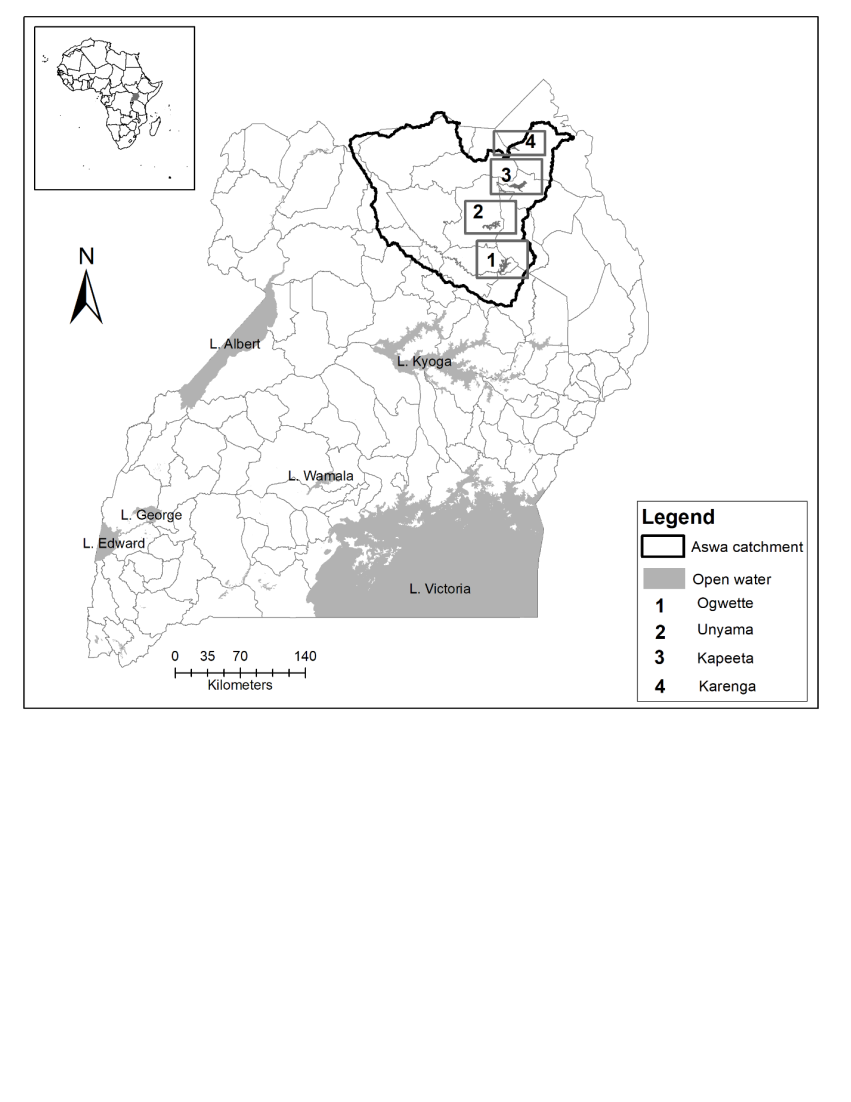 | Figure 1. Location of the Study Area |
2.2. Spatial Temporal Extent and Drivers of Wetland Use/Cover Changes
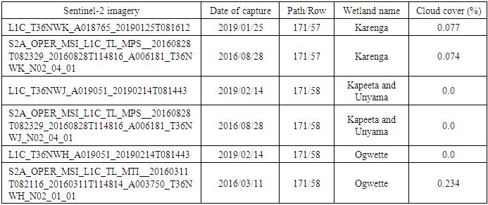
- A catchment-based approach (Aswa catchment) was used to assess the status of wetland degradation and ecological restoration. Two sets of Ortho-rectified and cloud-free Sentinel-2A satellite images of 20 m spatial resolution of 2016 and 2019 were downloaded (path 171, r 57/58) from the Earth Explorer geoportal captured in the long dry season month (December-January) and analysed (Table 1). Sentinel-2 images provide four 10m bands, six 20 m bands, and 60 m bands [10,33].
|
|
2.3. Status and Scale of Wetlands and Degradation
- Wetland degradation in this study referred to the activities that undermined the ecological functioning of wetlands to offer their usual goods and services. Wetland degradation was quantified using data on classified wetland use/cover loss and fires. Burning incidents are common due to the torrid conditions that underlie the studied sites. Image differencing method was used to extract areas that lost wetland coverage to other forms of land use types that could not be recovered, while the fire data was obtained from the Moderate Resolution Imaging Spectroradiometer (MODIS) Sensor to track its occurrence and intensity in the selected wetland systems [8]. The already processed fire data on natural fire outbreaks was obtained from the Fire Information for Resource Management System (FIRMS) (https://earthdata.nasa.gov/earth-observation-data/near-real-time/firms). This point data of 2019 was interpolated using the kriging technique based on the fire radiative power (FRP) into three classes (“low”, “moderate”, and “high”) using the natural break classification system. This was related to Sentinel-2 imagery. Wetland use/cover changes and fire datasets were used to determine wetland degradation. Changes in built-up areas and farmland were selected, reclassified into three classes, and overlaid with fire data to determine areas highly degraded. The datasets were analysed using weighted overlay methodology where wetland loss data was allocated a weight of 70% and fire 30%. The result was classified into three classes (“low”, “moderate”, and “high”) to define the intensity of wetland degradation in the studied sites. For each studied site, the levels of wetland degradation were aggregated to the parish level for easier estimation of required restoration needs and materials (Bamboo tree seedlings and pillars) and monitoring of the interventions. The study utilising procedure is not data intensive and suitable for assessing wetland degradation in developing countries where the resources available for data collection are relatively limited.
2.4. Best Practices and Lessons Learned in Conducting Wetland Ecological Restoration
- Out of the four studied wetland sites, the first ones to be restored were determined based on field assessment of wetlands (functions, condition, and value), stakeholder engagement, level of community awareness on wetland conservation and spatial analysis results (wetland loss and levels of encroachment) (Figure 2). In ascending order, the proposed wetland sites to be restored first were Kapeeta, Unyama, Ogwette, and Karenga. The data used to document the best practices of wetland restoration was out of taking a record of the steps undertaken to conduct wetland restoration intervention, from formation of wetland management committees, sensitisation of local communities, launching of wetland restoration activities to wetland boundary demarcation (100m interval) using concrete pillars (Figure 2) and planting of bamboo tree seedlings (200,000) at 5m interval. However, this process excludes the steps taken to identify the suppliers and acquisition of materials (procurement process). To develop the best practices of wetland restoration, this study took a holistic understanding of wetland attributes (morphology and status), wetland changes, wetland degradation, and restoration interventions that can enhance agropastoral livelihood diversity.
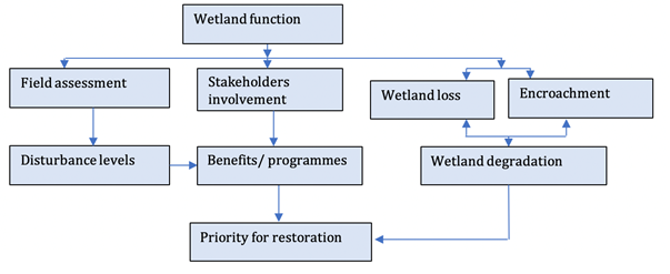 | Figure 2. Criteria used to select priority wetland systems for restoration |
3. Results
3.1. Spatial Temporal Extent and Drivers of Wetland Use/Cover Changes
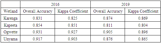
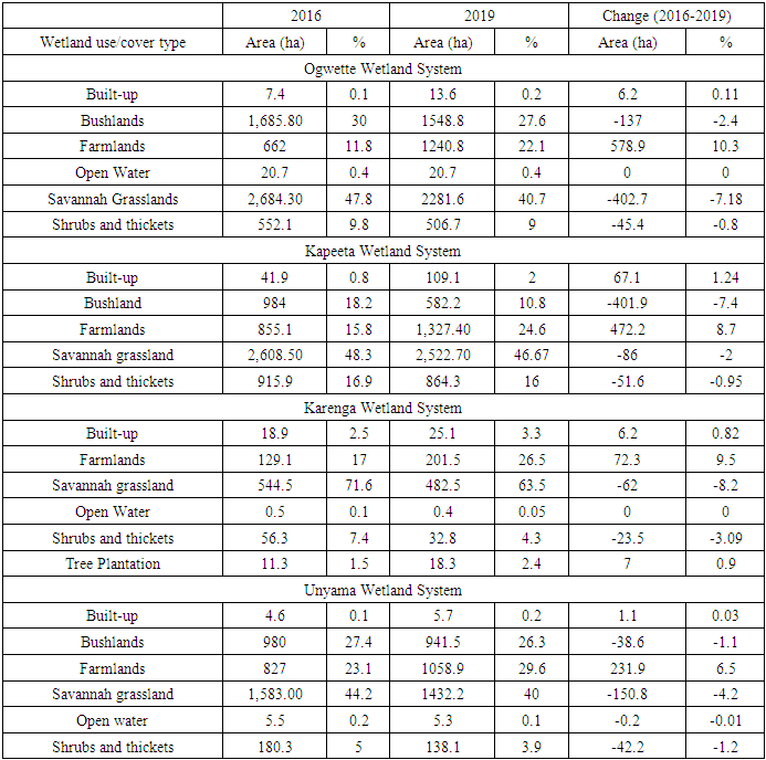
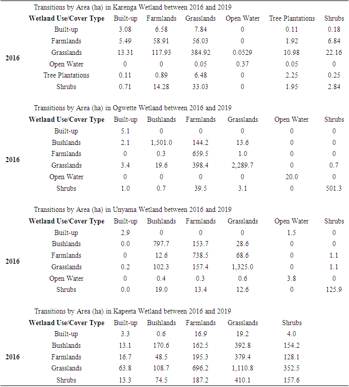
- In the studied wetland systems (Ogwette, Kapeeta, Karenga, and Unyama), small-scale farming and built-up (settlement) patches gained more land than those under natural vegetation types between 2016 and 2019 (Table 3 and Figures 2 and 3). A significant relative positive change in areas under built-up (settlement) occurred in Kapeeta and Karenga wetland systems, while in Ogwette (10.3%) and Karenga (8.7%) this change only happened in small-scale farming wetland use. Of the areas under natural wetland vegetation, savannah grasslands and those dotted with small and scattered bushland patches were the most degraded or lost mostly in Kapeeta and Unyama wetland systems. However, it is only the open water wetland system (valley dams) that did not experience relative changes in the assessed period in Karenga and Unyama. Secondly, the wetland system that has seen propagation and growth in the spatial coverage of exotic tree plantations (Eucalyptus) is Karenga (Figure 2). This simple process provides useful information on the types and distribution of past and current elements of wetland degradation and which effective restoration interventions could timely counteract the rates of encroachment. The transitions in wetland use/cover changes revealed that the gains in built-up areas were mainly because of loss of land in areas covered by grassland, wetland cover type in Kapeeta and Unyama; while the gains in farmland were attributed to grasslands, bushlands, and shrubs (Table 4).
|
|
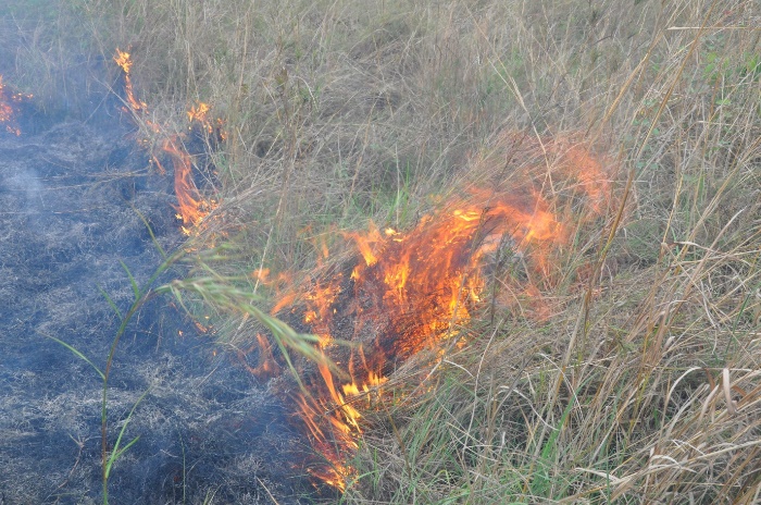 | Figure 3. Burning in Ogwette wetland system |
|
3.2. Status and Scale of Wetland Degradation
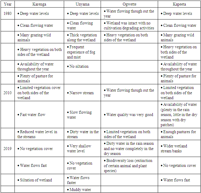
- Prior to effective wetland ecological restoration, it was also important to historically understand the local community’s perceptions on the status and trend of events in the wetlands for at least the past 30 years. The results from the focus group discussions revealed that in the 1980s the wetland systems were well endowed with good hydrological regimes and properties (high water levels, water quality, water availability, wider streamflow channels), healthier wetland vegetation and a variety of wild animals (Table 6). However, by 2010, the respondents reported that the extent of wetland vegetation cover had declined, the wetland stream channels narrowed, and the waterflow rates reduced. This implies that changes in water and vegetation status were the most observable indicators of wetland degradation. Whereas, in the year 2019, the wetland flora and fauna had been lost while the water levels and quality in the prevalent water sources (rivers, springs) had deteriorated. One of the key informants explained that “Despite the harsh semi-arid conditions of the wetlands, the unregulated anthropogenic activities were more lethal to the existence of wetlands”.
|
|
|
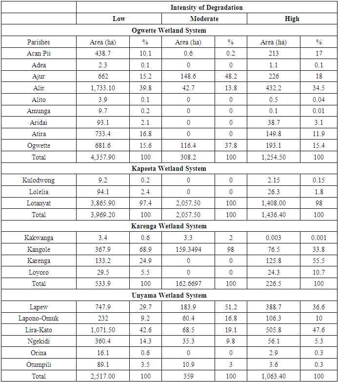
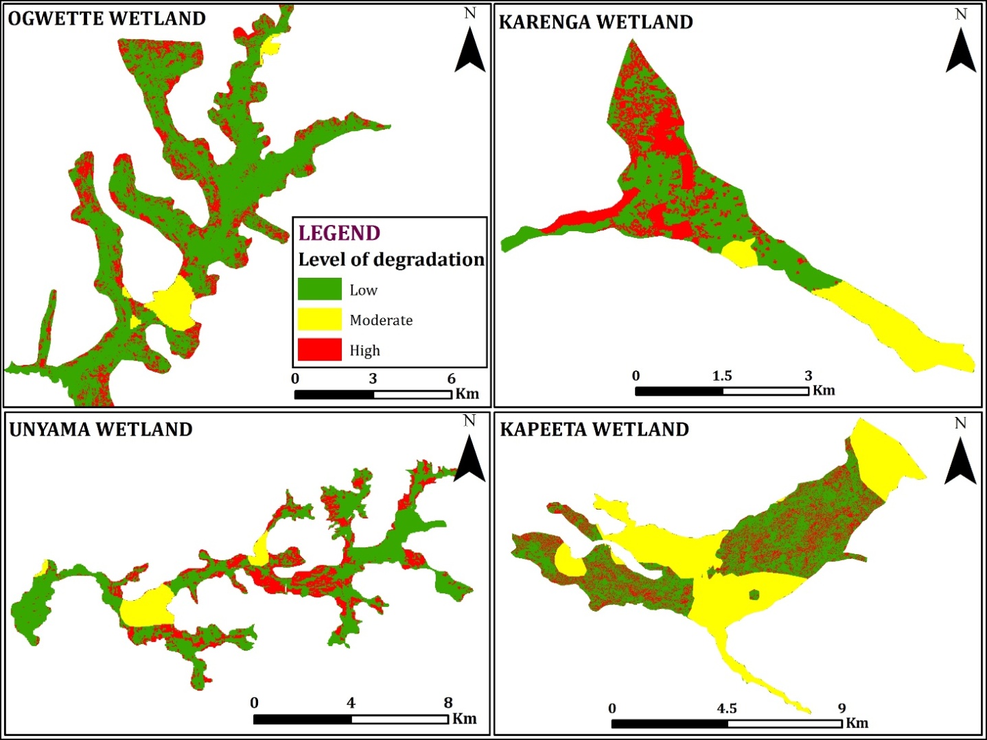 | Figure 4. Degradation status in the study wetlands |
3.3. Ascertaining the Best Practices and Lessons in Conducting Wetland Ecological Restoration
- Based on the aforementioned information in assessing wetland changes and degradation, this study presents the practices that were followed in conducting wetland restoration activities and the lessons learned in this process. Much as these processes were followed to restore these wetlands in semi-arid areas, they could also be useful for permanent wetlands ones too and in the tropics and other places of the world. The steps are as follows:Step 1: Baseline assessmentBaseline assessments are crucial in understanding the ecosystem functions and importance of the catchment to the communities. Setting up restoration goals for any catchment requires knowledge of the past range of conditions that existed prior to its degradation, and what the future conditions might be. In this case study, the baseline assessments helped to identify priority catchments within the water management zone (basin) for restoration. The information in addition was used in defining the specific goals for the restoration, considering any possible changes that could affect the system being restored, and focusing on restoring possible ecosystem functions.Step 2: Situation analysisIn the case study, this was undertaken as an independent step, much as it may be done concurrently with the baseline assessments that outline benchmarks. The situation analysis helped to identify key stakeholders and the causal agents of degradation for redress. Persistence of these causal effects may lead to failure in the restoration process. It is therefore imperative to identify these causal factors of degradation and eliminate or amend them. Much as degradation may be caused by one direct impact such as wetland filling, it may also be caused by the cumulative effect of numerous indirect impacts, such as changes in surface flow caused by gradual increases, said in the number of permanent houses, and even the number of different categories of access roads in the catchment. While identifying probable sources of degradation, it was worthy looking at upstream activities, as well as at direct impacts on the immediate hotspot site.Step 3: Mobilization of stakeholdersAwareness raising and sensitization of stakeholders is crucial to build a common understanding and appreciation of the degradation challenges in the catchment. With a consensus built amongst the stakeholders, necessary institutional arrangements need to be established to develop restoration strategies to address the degradation challenges. The situation analysis in the previous step defined the key stakeholders to engage in the process of restoration. Equally important were the absent landlords, who may be temporarily hiring out would-be undisturbed pieces of land adjacent or within the identified hotspots. Failure to bring on-board such landowners may downplay the restoration processes, since those who hire them are timely and their objectives may be contrary or not in line with those of restoration as such. Through a participatory process, the lead agency together with the key stakeholders must develop a theory of change, and subsequently clear, achievable, and measurable goals for restoration to succeed. With the goals set, restoration action plans that define implementation framework were developed with clear milestones/indicators for measuring success. In addition, all stakeholders affected by the restoration need to understand and own up the set restoration goals to avoid concomitant misunderstandings. This would ensure the much-needed community support for the long-term viability of the restoration process. One of the outputs of the mobilisation exercise was putting in place appropriate restoration institutional arrangements such as the formation of parish wetland management committees, to oversee the implementation of restoration activities. Such arrangements aided in the review as to whether the proposed restoration activity was feasible, considering scientific, resource envelope, social, and other considerations. Step 4: Identification of model sites as reference sitesIdeal reference catchments or wetland systems ought to exhibit undisturbed natural settings within the same landscape where restoration is targeted. It may at times not be possible to easily identify such undisturbed ecosystems within the landscape and a related restored landscape can serve the same purpose. In this case study, Adollo wetland in Otuke district was identified as a model site comparable in structure and function to the proposed restoration sites before degradation. The reference site was used as model for catchment/ecosystem restoration and as yardsticks for measuring the progress of the restoration process. Much as it was possible to use historic information on sites that have been degraded, information on historic conditions were largely scanty, making it more useful to identify an existing, relatively healthy, similar site as a guide for restoration processes.Step 5: Planning to anticipating future changes. Identification of probable risks and respective mitigation actions cannot be underrated in catchment restoration processes for smooth implementation of planned activities since the environment and communities of focus are not static. The foreseeable ecological changes such as successional processes and societal swifts should always be incorporated into the restoration planning process.Step 6: Implementation of restoration action plansGiven the diversity and multi-functional nature of ecosystems, restoration is a complex process requiring the integration of a wide range of disciplines including ecology, aquatic biology, hydrology, planning, communications, and social science, among others. The planning and implementation of restoration action plans therefore should involve people with experience in the disciplines needed for the activities (multi-disciplinary team). Different government and non-government institutions including private organizations may be able to provide useful information and expertise in the restoration process. Effective leadership is a requirement to bring various disciplines together to work as a team.
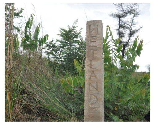 | Figure 5. Demarcation of Wetland boundary |
4. Discussion
- In this study, we assessed changes in wetland use/cover and profiled the best practices to follow while conducting wetland restoration in seasonal wetlands. We observed that both natural and anthropogenic activities unidirectionally piled more pressure on the components of the wetland and services that have ultimately resulted in wetland degradation and loss. The most significant direct and underlying drivers of wetland use/cover changes were wetland cultivation, deforestation, invasion of invasive weeds, occurrences of flash floods and poor market linkages. For example, wetland cultivation is highly associated with unsustainable activities such as bush/residue burning, degradation of riverbanks and dam embarkments due to use of rudimentary tools, poverty, and ignorance. As a result, these factors have caused deterioration of water quality and quantity, reduction in wetland size and distribution, and loss of biodiversity. This finding is in coincidence with those of [1,2,5,8], who reported that wetland threats such as cultivation, deforestation and siltation undermine the hydrology and vegetation status of wetlands. However, [12,21] argued that wetland cultivation, for instance is associated with some ecological benefits like provision of food and shelter for birds, recharging groundwater, and enhancing ecosystem development. The study area is situated in a drought-prone region that is highly characterised with high food insecurity and poverty. Therefore, this result was highly expected due to the high demand to increase domestic food supplies and uncoordinated supply chains of wetland agricultural produce [26]. Examining wetland use/cover changes can give an insight into the degradation status of the wetland. This research clearly shows that the wetlands investigated were highly degraded. The communities interviewed reported a reduction of wetland ecosystem services provided over time. This was attributed to loss of wetland vegetation, diversion of wetland stream channels, and burning activities. These were caused by increased demand for agricultural land, diversification of livelihood (harvesting of art and craft materials), and uptake of paddy rice cultivation, among others, which in turn have led to the loss of wetland flora and fauna and deterioration of water quality than what the wetlands used to provide since 1980s as perceived by the households. similarly agrees that the intensification of anthropogenic activities infers information on wetland degradation levels. It is worthy to note that in the studied region, areas with lower levels of wetland degradation were attributable to the remoteness of the areas comparing with those that were closer to the urban or settlement areas. This result was expected because these seasonal wetlands are highly under immense pressure from overgrazing, charcoal burning, and intensive agricultural practices by the adjacent communities. However, wetland management interventions planned or implemented to conserve these wetlands are highly affected, lack of personnel, funds, tribal and land conflicts, and poor accessibility, among others.Wetland restoration procedures may differ from region to another. This study provides steps undertaken to restore degraded areas identified during the wetland use/cover change analytical initial process. The activities implemented included conducting baseline and situational assessment, mobilisation of stakeholders, identification of model sites as reference sites, planning for future changes, implementation of restoration action plans, sustainability, and monitoring and evaluation. Preliminary assessments were conducted to set restoration goals, identification of stakeholders with high interests and influence, and collecting data on the state of the wetlands. [30] argued that conducting wetland baselines can help to understand or quantify the trends of ecosystem services. Stakeholder awareness activities about the benefits provided by wetlands gathered public support by the community for wetland restoration [34]. In the restoration process, model sites were identified with the help of stakeholders that were ought to exhibit more or less undisturbed natural settings within the same landscape where the restoration was targeted. These sites were identified for the purpose of monitoring restoration interventions, and learning. This activity significantly helped to identify wetland biodiversity hotspots for conservation.Another significant step undertaken in the restoration process was the identification of probable risks and their associated mitigation measures. This activity helped to promote activities that aimed to mitigate the ecological risks and identify the potential of the wetland system to supply ecosystem services. In the process, habitats that were more likely to persist or become vulnerable to future changes were prioritised for restoration and in the end could result in a reduction of flooding risks. [30,31] supports this notion that restoring wetlands can mitigate climate change. While in the planning and implementation of restoration activities, this study found out that it is a holistic process that requires effective project coordination from procurement of restoration materials, communication, mobilisation of stakeholders and monitoring. For sustainability purposes, available government structures (technocrats and political wings) should be at the forefront of mobilising communities and implementation of the restoration measures. These can allocate final resources and integrate wetlands restoration into planning frameworks. Finally, this study recommends building a monitoring and evaluation system to facilitate data collection and tracking of restoration activities implemented. The purpose of monitoring these activities is for comparison purposes of restoration measures with the different sites to share lessons and experiences. Restoration monitoring aims at ensuring that the activities are fully implemented and well designed. Similar observations were also made by [30] that found that monitoring can help evaluate the effectiveness of the implemented restoration activities and improve restoration design.Much as this study was conducted at a regional level in an area faced with frequent and severe droughts and food insecurity, the results offer lessons to many practitioners to borrow worldwide in undertaking wetland restoration activities. This study recommends equal participation of men and women which helps to prevent conflicts on land and approval of restoration activities in their neighbourhoods. Women undertook most agricultural activities in the wetlands, though men contributed the most income. It also recommends encouraging wetland restoration through income generation. Restoration interventions that aim to increase the diversity of livelihood options should be promoted upon conducting thorough research, training, and sharing of experiences with beneficiaries. Above all, ensure effective coordination of planning and stakeholders to induce large owners of land adjacent wetlands to participate in wetland restoration activities.
5. Conclusions
- In the studied wetland systems (Ogwette, Kapeeta, Karenga, and Unyama), small-scale farming and built-up (settlement) patches gained more land than those under natural vegetation types between 2016 and 2019. The major drivers of wetland use/cover changes were wetland cultivation, deforestation, occurrence of flash floods, and poor market linkages/prices of produce. The second category of drivers of wetlands were climate change, siltation of the riverbed and valley dams, invasion of invasive weeds, species colonizing wetlands/farming lands, and introduction of new pests and diseases. In 1980s, the wetland systems were well endowed with good hydrological regimes and properties (high water levels, water quality, water availability, wider streamflow channels), healthier wetland vegetation and a variety of wild animals. However, by 2010, the respondents reported that the wetland vegetation cover had relatively reduced in size, the wetland stream channels narrowed, and the waterflow rates reduced.To counteract wetland degradation, the best steps that ensued an effective wetland ecological restoration included conducting baseline surveys, stakeholder consultations, identification of reference sites, planning for future changes, implementation of restoration action plans, self-sustainability, and monitoring. What stood out of the restoration process was the need to encourage equal participation of men and women, raise awareness and provide education, encourage restoration through income generation, and promote the sustainability of restoration interventions. For successful restoration interventions there is need to improve women’s and men’s access to and control over productive resources such as land, agricultural support services and markets, which contributes to empowerment and equips them to deal with extreme conditions, rather than degrade and deplete certain resources like the wetland systems because of lack of alternatives. Develop informal sector enterprises and alternative livelihood possibilities through making credit available to both women and men and to ensure that structures are in place to continue providing facilities in the post-project phase, through training and continued on-site technical assistance.
ACKNOWLEDGEMENTS
- The research was supported by the International Union for Conservation of Nature Uganda through the Wetland Restoration Programme.