Mairomi H. Wirngo1, Moupou Moise2, Stephen K. Ndzeidze3
1Department of Geography, Higher Teacher Training College, HTTC (ENS) University of Bamenda, Bambili, NW Cameroon
2Department of Geography, Faculty of Arts, Letters and Social Sciences, University of Yaounde I, Yaounde, Cameroon
3Department of Animal and Rangeland Sciences, Oregon State University, 222 Withycombe Hall, Corvallis, USA
Correspondence to: Stephen K. Ndzeidze, Department of Animal and Rangeland Sciences, Oregon State University, 222 Withycombe Hall, Corvallis, USA.
| Email: |  |
Copyright © 2021 The Author(s). Published by Scientific & Academic Publishing.
This work is licensed under the Creative Commons Attribution International License (CC BY).
http://creativecommons.org/licenses/by/4.0/

Abstract
Rangelands in the Western highlands has notably witnessed change in vegetation cover and vegetation composition largely accounted for by increasing growth of invasive weeds in grasslands. Dominant native grass suitable for livestock grazing are Hyparrhenias and Sporobolus. Very noticeable invasive plants like Pteridium aquililium adapts to higher elevations while Chromolaena odorata invades lowlands. Rangelands constitute an important resource base with diverse functions for livelihood and food security. There is a coalesce centenary history of land use for grazing spanning from pastoral nomadism in the past to present settled pastoralism with open public and communal grazing sites with occasional farmer grazier conflicts. The rational for this study is that limited information is available on the impact of weeds on rangeland degradation. Weed invasions are facilitated by landuse-grazing/fire and bioclimatic factors and changes vegetation composition. This study focused on evaluating vegetation composition in rangelands along selected transect, represented different in cross-sections, cutting across valleys, foothills, slopes, hill summits and plateaus in four topographic units. Field results reveal an association with altitudinal zonation with Chromolaena odorata highly invasive below 1200m in low altitude areas, a mix of Chromolaena odorata and Pteridium aquililium in mid altitude areas between 1200m-1550m and Pteridium aquililium in highlands above 1500m. Bioclimatic factors greatly determine susceptibility to spread and other risk factors (roads, rivers, fragmentation) determined patch size and density. Weed patch density was highest closest to roads as risk factors. Over 56% of rangelands are infested with weeds varying from dense (62%), moderate (23%) to light (15%). According to altitude, weed presence in grass composition stood at 13% (zone one: 300-1000m), 22% (zone two: 1000-1500m) and 65% (zone three: above 1500m). The magnitude and impacts are undoubted and landscape change is therefore axed around land use with variables like grazing and fire accelerating vegetation change.
Keywords:
Invasive weeds, Mapping spatial distribution, Monitoring system, Rangeland Ecosystem, Grass fields
Cite this paper: Mairomi H. Wirngo, Moupou Moise, Stephen K. Ndzeidze, Mapping and Monitoring Invasive Weeds in the Savannah Grasslands of Western Highlands in Cameroon, International Journal of Ecosystem, Vol. 11 No. 1, 2021, pp. 17-29. doi: 10.5923/j.ije.20211101.03.
1. Introduction
Rangelands cover about 60% of the Western Highlands Savanna grasslands, in the Northwest Region of Cameroon. They are increasingly infested by noxious and invasive weeds (Lambi and Ndenecho, 2010, Ndzeidze et al, 2016, Mairomi et al, 2016); whereby thousands of acres of rangeland have been seriously infested with weeds (Mercier, 2009, Ngane et al, 2012). Very little is known about or no surveys or estimation of the spatial and temporal extent of infestation over the years have been conducted. Current trends of rapid changing agrarian landscape and major challenges on grazing reveals invasive weeds are spreading across grasslands disrupting rangeland ecosystems and rendering hectares of grasslands almost worthless (Norgrove et al, 2014). Compounded by significant reduction in wildfire as a factor in checking invasive species, other control variables like grazing have rendered rangeland susceptible to resurgence of these unwanted species. Pteridium aquililium is noted as a major invader in highlands (Pamo et al, 1998) and Chromolaena odorata in the lowlands amidst other invaders (Norgrove, 2014, Mairomi, 2016). Rangelands here are very important resource for livelihood and constitutes the prime socio-economic and ecological backbone. Practically there are no institutional policies in place to monitor and document the increasing invasive species posing the greatest threats to rangeland stability, sustainability and livestock production. However, judging from the frustration on the side of pastoral nomads and local ranchers, there’s quite substantial evidence justifying severe ecosystem adjustment and changes due to invasive weeds heavily infestation in grazing areas (“weeds have enormously reduced our pastures, some areas are ruined with total avoidance where skin injuries are the norm, this makes pastoralist to concentrate on weed free areas causing degradation. Worse of all, the grass composition is now dominated by weeds spreading very fast” Ardo Eggi Sule/Tan/March/2015). Our research therefore is set to design a preliminary survey to map and monitor some of the most pronounced and rapidly spreading invasive weeds never mapped before. Rangelands here as anywhere in Cameroon and Sub Saharan Africa, are generally considered as no man’s land by the population, however, they are classified as state lands and considered as communal lands meant for use by all and to which different individuals, groups or communities attribute variable more or less appreciative perceptions (Mairomi, 2012, Heifer Project International, Cameroon 2001). Livestock Grazing across these rangelands is largely practiced by the Mbororos on the hills during the rainy season and transhumance during the dry season (Ngwa, 1998, Ndenecho, 2005, SNV-MBOSCUDA, 2008). However, this system is losing ground to settled pastoralism (HEIFER, 2001, Vabi, 1993, 2003). Pastoralist Family units and their livestock depend largely on rangelands for their well-being especially for 80% of all local staple agricultural food production and other needs coming from the livestock. Open free ranging grazing system is common, however, following differential effects of evolutionary grazing histories linearly linked to overgrazing, this method is gradually being abandoned for sustainable modern practices. Major challenges for sustainable rangeland management includes herd optimization and galloping stocking densities, bush burning and overgrazing suggest “tragedy of the commons”. Cattles were introduced by nomads notably the Mbororos and Akus during the early 20th century from Nigeria and Adamawa (Ngwa, 1983). After a century of differential grazing, exotics and invasive species of weeds have become a serious problem across the rangelands. This paper therefore examines the changes on the landscape and vegetation composition with examples of invasive plants in humid tropical milieus. Land use is a mosaic of food and cash crop cultivation by the native population and grazing by the Mbororos. Research on grazing lands in the region mostly focused on irrational exploitation of pasture, uncontrolled use of fire and degrading grazing reserves. Boutrais (1984), Ngwa (1983), Ndzeidze (2004), Ndenecho (2010), have researched on the functions and ecological values of rangelands of this region. They addressed the implications of related land use (grazing, farming, transhumance) practices on rangelands giving a close focus on rangeland functions that generate income and degrade the landscape. But none of these works focused on weed infestation as a major threat in rangelands in the region.
2. Materials and Methods
2.1. Description of the Study Area
The study is within the western highlands and lies between latitudes 6° 63’ and 7° 50’ north of the equator and longitudes 6° 11’ and 7° 16’ east of the Greenwich meridian (Figure 1). The Western Highlands are composed of soaring mountain peaks, deep valleys, high lava plateau and intermontane plains. Two land systems can be identified in the southern eastern part: an intermontane plain and a high plateau. The plain is in the Upper Noun drainage basin with an average elevation of 1,180 meters known as the Ndop plain. The flood plain is drained by the Noun River and is liable to seasonal flooding. Moist montane forest is the climax vegetation community of the wetter mountains. Lowland evergreen forest is found at elevations below 300m above sea level. These climax floristic communities have been anthropogenically degraded and what exists today is a complex mosaic of montane woodlands, tree and shrub savanna, grass savanna, farms and fallow fields derived from tropical montane forests (Nkwi and Warnier, 1982; Tamura, 1986; Ndenecho, 2005). Grass compositions are dominated by Hyparrhenia and Sporobolus with varying associations of Loudetia, Setaria, Andropogon, Paspalium. Herbaceous grasslands are remarkable from the Sabga hills through Jakiri to Nkambe. The western parts of the region from Wum through Esu to Misaje and Dumbo in the north is largely a shrub savanna. To the northeastern flanks is an extension of another plain known as the Mbaw Tikar plain drained by River Mairin surrounded by the neighbouring Nkambe highlands to the west.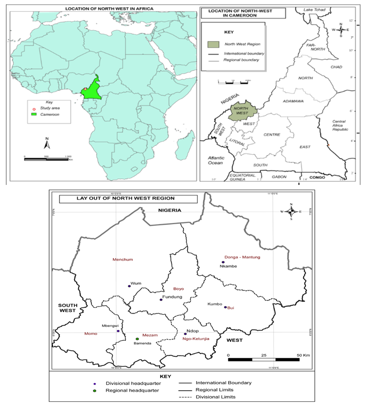 | Figure 1. Location of the Bamenda Highlands in Cameroon |
Early documented rangeland studies in the Western Highlands of Cameroon dates to 1965 by FAO (Hawkings and Brunt, 1965) as an evaluation of rangeland in the Grassfields under an expanded program of technical assistance. This FAO study constitutes a baseline inventory this study has used on different designated site for primary comparative evaluations over the years. Consultation and systematic exploration of textbooks, theses, dissertations, research reports, periodical journals and internet rangeland related websites gave in-depth assessment of existing related studies. Important consultations were also done at the Ministry of Livestock, fisheries and animal husbandry, ministry of scientific research and innovation, institute of agricultural research and development. Field work was conducted in the following areas; the Dumbo-Kimbi and Mayo kela areas in the Misaje lowlands, Akwinto, Bihjeng, Nkonchep and Binka in the Donga mantung plateau, Bum and Nyos in Boyo, Waindo-down, Waindo-up and Menchum valley in Menchum, Sabga, Ndawara in Ngoketujia and in Tan, Ntunir and Berlem in the Bui plateau. During the visits, data was collected by direct field observation, inventory through transects and quadrats. This was complemented by interviews granted to resource persons. Key persons were contacted and interviewed. These included the regional delegate of the Ministry of Livestock, fisheries and animal husbandry (MINEPIA), delegate of livestock statistics and pastoral hydraulics and some divisional and sub-divisional delegates of the same ministry. Also, heads of “Ardorates” or grazing units (Ardos) and some elderly pastoralists were interviewed. An interview guide composed of 12 keys aspects was used relating to weed types, distribution, spread, land use practices and management. It is the analysis of data collected that produced the presented results.Field observation principally focus on weed infestations (spatial distribution and risks factors), land use change, grazing practices, range degradation and improvement from April-May 2014 to the second field work from June to July 2014 and the final field trip in February 2015. Firstly, we identified weed location and patch size then proceeded to mapping and tracking of weeds with GPS loggers. Observation was facilitated by information from graziers, extension workers or delegates of MINEPIA and especially interviews with “Ardos” who provided ground guidelines (infested areas and relative abundance with historical appreciation of the presence and absence) for participatory mapping with the aid of key informants-cattle care takers “Gainakos”.Transect lines with quadrats were examined in a valley to hilltop inclination in order to have a cross section examination. Detailed situations in upland plateau areas were examined in Sabga, Jakiri, Mbelem and Mbinka, and lowlands in Wum, Dumbo, Misaje and Mbonso. A close examination of vegetation composition in these areas shows a resemblance in the high plateau areas. With quadrat analysis, soil cover and vegetation composition of Hyperrhenia grassland and Sporobolus grassland that dominate the area was realized. Using slope, elevation and observation criteria, sites were selected for transects and quadrats to be established. 64 transect lines with quadrats were used for an evaluation of range ecological resources in four topographic units in different ecological zones. Transects of 50x4m with prospective quadrats of 1x1m were laid out randomly to accommodate both the herbaceous and woody vegetation in a cross section from sites selected in valleys, slopes and hill summits. Transect quadrants were used to assess the edaphic conditions, related climate, forage resources and land use in response to seasonal changes and their effects on vegetation productivity during the main growing seasons, grass species, and flowering calendar. Rangeland health evaluation is best between the months of June and July. Field work was done with assistance from a botanist to classify plants with a full flowering head and other vegetative parts collected and identified or at the National Herbarium, Yaoundé. All identified grass species were classified into highly desirable, desirable and less desirable based on the information obtained from the pastoralists and the insights from livestock or veterinary technicians and other literature. Rangeland health through range condition, trend recognition and value of indicator species was to indicate conditions ratings for upward or downward range trend, site evaluation by state of vegetation and soil, stratification of vegetation and land use according to productivity and quality of management plans in use. The main factors that were investigated are; analysis of the plant community (plant species present and their relative abundance), vigour of selected species, amount and dispersion of soil cover and extent of soil erosion. Key indicators were thus examined with possible changes and factors that lead to invasiveness.
3. Results
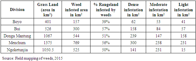
Results portrays significant weed infestation in North west region of Cameroon. More than 52% of rangeland is weed infested with a good percentage of about 40-55% is weed free and requires caution (Table 1). Over 2295 sq.km, are infested of a total of 4420 sq.km. The acreage invaded varies from one grazing area to another depending on variables like site suitability, grazing, fire, and stocking density and impacts on rangeland dynamics are examined in quadrat data appreciation. Table 1 presents the area invaded according to various divisions. It stood at 57% for Bui, 51% in Donga Mantung, 50% in Ngoketunjia, 52% in Menchum and 39% in Boyo division. This variation is attributed to site-specificity explained according to site suitability in altitude and other variables as grazing and fire. Also, the altitudinal distribution of Chromolaena odorata and Pteridium aquililium is presented in Figure 2 following field mapping. C. odorata largely falls below 1200m (Misaje lowlands~800m) but P. aquililium is notice more in altitude (Dzeng-Mbiami plateau~2200m).Table 1. Weed infested areas in the Grass fields
 |
| |
|
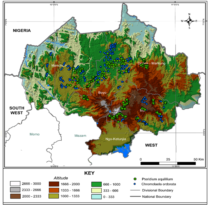 | Figure 2. C. odorata and P. aquilinium distribution with altitude (m) (Source: Field mapping, GPS points, 2015) |
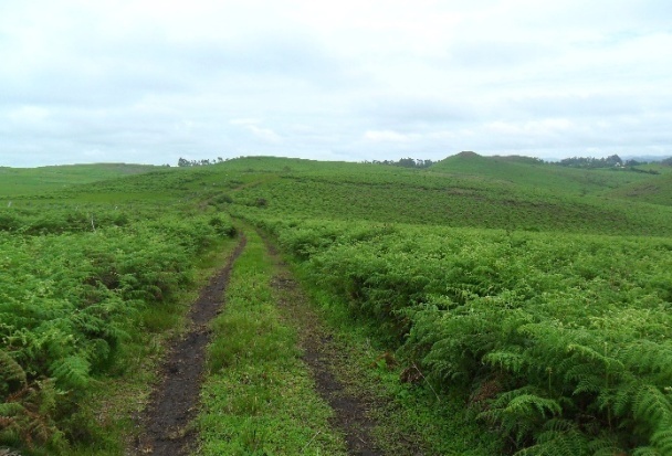
A substantial land area is under dense infestation (142 km2) indicating the density, extent and problems generated. This is when penetration by cattle is met with difficulties and avoidance become obvious mounting grazing pressure (impairment) on the weed free areas causing degradation. Moderate infestation (231 km2) is turning to dense and worse is the light infestation (152 km2) indicating the rapid spread especially in vulnerability corridors. Infestations across some landscapes in the area are captured in photos 1 to 4.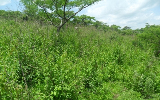 | Photo 1. Young C. odorata invasions in Wum |
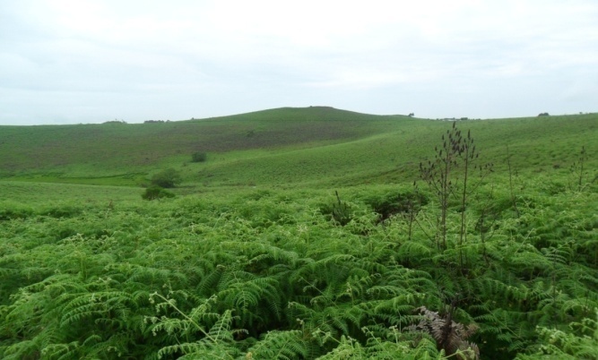 | Photo 2. Bracken fern infestation in Berlem, Kumbo |
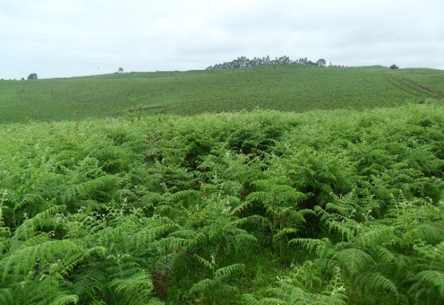 | Photo 3. Dense fern invasion in Ntunir |
 | Photo 4. Fern invasion in Dzeng-Mbiami stretch. (Source: Mairomi, 2015) |
The outcomes for rangelands and the grazing community includes shifts in species, altered fire regimes (burning rather during the peak of the dry season with hot fire to eliminate old rank weed grass), reduced pastures, impairment of the other grazing areas, increased cost of livestock production amongst others. The dynamics in community composition is not temporary but rather is turning to a shift in succession patterns to self-perpetuating annual communities. In the spread front (edges of weed patches) communities of weeds especially exotics compete directly and indirectly with native plants, directly by the struggle for food resources, water, and light and indirectly by stochastic distribution of seeds, litter accumulation, fire frequency.
3.1. Transect Quadrat Data Shows a Significant Relationship between Rangeland Use and Change in Ecological Character
We propose three classes according to altitude; low altitude areas (300-1000m), mid altitude areas (1000-1600m) and high altitude areas (1600m and above). The pasture ecological zonation or pasture resource niches present a resource rich situation that is increasingly being affected by weeds.
3.1.1. Zone 1: Rangelands between 300-1000m of Altitude
These are low altitude areas that present a mixed cover of degraded semi-deciduous forest on valley slopes (Ako with rainfall varying between 1500-2000mm), wooded savanna, and tree and shrub savanna. With low elevations as such, rainfall in some localities attain over 1800mm. Rangelands in this niche are mostly grazed forest lands, wooded and tree-shrub savannas. Most grazing areas within this elevation range correspond to transhumance grazing sites (dry season grazing grounds with fresh pastures). An examination following altitude covered much of the rangelands in the Dumbo vicinity, Njinikimbi valley, the Ndop plain, the Mbaw Tikar plain and the Menchum valley. The main graminae found in the tree and shrub savannas are Pennissetum purpurum (23%), Hyparrhenia spp (42%), Andropogon (10%), Pennisetum clandestinum (12%) and weeds (13%). Weeds in these ecological zones were dominantly Chromolaena odorata, Satureja sp and Solanum torwum. The trees shrub savanna is by a dense complex of gallery forest cover in the inland valleys but the dominant species in the savanna being Terminalia glauceens, Lophira lanceolata, and Annona senegalensis. The woodland savannas that characterize the Mbembe grasslands are dominated by Burkea africanna and Daniella oliveri. Some of these trees and shrubs are frequently browse by cattle especially during transhumance for pasture supplementation.
3.1.2. Zone 2: Rangelands between 1000 to 1600m above Sea Level
Rangelands in the Wum, Esu and the Zhoa council area, the Misaje area, the Bamti-Noni landscapes, Baba, Tan-Mbokam-Lip areas fall within this range. These are medium altitude zones. It is sub-humid with 1500 to 1800 mm of rainfall per year and 3 to 4 dry months. Its vegetal composition is dominated by montane forest refugia from steep escarpments to stiff gradients. Most of it is degraded around 60 to 80% and is more of tree shrub savanna and the floristic composition abounds with a network of gallery forest that remains dense. Daniellia oliverii, Lophira lanceolata characterize them and in those areas with more of woodland savanna, Burkea africana, Borassus aethiopum are in addition to the above cited species dominant within these areas. Grassland’s species composition ranged from Pennisetum clandestinum (15%), Hyperrhenia spp (15%), Sporobolus africanus (35%) Setaria, Andropogon, Loudetia and Melinis (13%). These are mainly transitional range sites. Hyperrhenia is significantly reduced to the advantage of Sporobolus. According to some of the Fulani graziers living in the study area since the early post independent (1960), the most significant change in vegetation composition has been increase in Sporobulus cover and Pteridium aquilinium. Between 1000-1400m, Chromolaena odorata remains the leading weed because temperatures complimenting rainfall at these altitudes with micro ecological conditions are suited for its expansion. But C. odorata here is in a mix with Pteridium aquililium and constitutes about 22% of grass composition.
3.1.3. Zone 3: Elevations above 1600 m
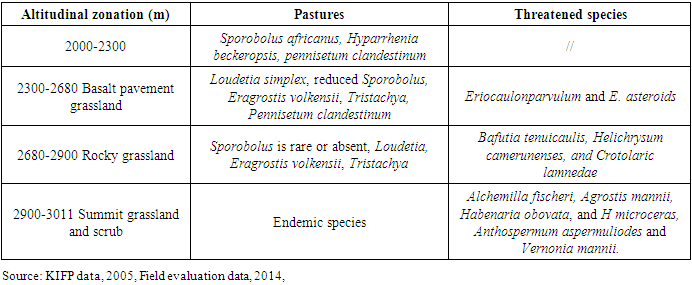
The mean annual rainfall generally exceeds 1700 mm. It is a typical high plateau area which is classified as a montane zone. Sabga-Ndawara stretch, Jakiri-Kumbo-Mbiame, the Nyos area and the Nkambe highlands constitute locations within this range. Elevations between 1600-2400m are dominated by Sporobolus and recorded the greatest weed infestations of Pteridium aqulilium. For example, the largest Pteridum aquililium weed patches were recorded in Berlem grazing area in Kumbo (2100-2250m), Tadu-Taasheem grazing areas in Jakiri (1960-2300m) and in Binka rangelands (1600-1750m) in Nkambe. The floristic compositions witnessed a remarked increase of Sporobolus pyramidalis (46%), Pennisetum clandestinum (18%), and Pteridium aquilinium (weeds, 22%). Setaria, Andropogon, Loudetia and Melinis constitutes close to 15%. The greatest weed invaded areas are located within this pasture ecological zone. Pteridum aquililium flourishes in this zone and in high invaded areas like in Berlem, Tadu, Fungom or Binka, this weed could even constitute more than 65% of the floral composition and over 80% of ground cover with Emelia pratemisa in the understorey.Being a montane zone, most of the mountain forests have degraded and what remains is a degraded montane forest and in other cases reduced to tree and shrub savanna whose floristic composition potrays forest edge species (ecotones). Some of these are Hypericum lanceolatum, Lasiosiphon glaucus that are invaded by Pteridium aquilinium. These constituted the grazed forest lands in the area. The zonation of the Evergreen Mountain Forest lies between 1700 to 2100 m above sea level. Its greater cover remains the Oku-Ijim stretch. Degraded patches are conserved in some areas like Mbiame forest. It is dominated by Schefflera abyssinica, and Carapa grandflora. Other common trees are Syzygium staudtti, Schewenfurta mannii, Pygeum africanus, Rapanea neurophylla and Barsama abyssinica. Small trees include Nuxia con gesta, Ixora foliosa, Pittosporum mannii and Clausena aniseta. Afro-alpine grasslands exist above 2100m altitude and cover the high lava plateau and mountain crests. Hyparrhenia spp remains the dominant grass in the grasslands and montane short grassland occurs between 2360m and 3000m. This grassland is derived from bamboo forest and thickets due to fire hazard, deforestation, and retreating tree species. Main grass species include Eragrostis volkensii and Tristachyabut Pennisetum clandestinum is also well established. These zones have been greatly invaded by Pteridium aquililium and Emilia pratemisa. Even though these areas are mainly wet season range sites, they sustain a lot of small ruminants like sheep and goats in the dry season. Weeds are increasing especially in open understorey areas where Kikuyu grass is found in expanse. This was greatly noticed in the grazed forest lands and grasslands of the Kilum mountain forest harboring goats and sheep. Montane afro-alpine grassland grazing takes place and is dominated by sheep and goat rearing. Due to degrading effects, cattle rearing is limited in altitude. Floral grass composition changes with altitude and variables like fire and grazing have played a great role as change is axed on them. The combine effect of grazing and fire cause change in plant composition as well as threats to some species, some of which are endemic in high elevations (2900-3011m). Table 2 demonstrates this pasture zonation in altitude with threatened species.Table 2. Altitudinal zonation, grazing and threat in species diversity in the Oku upper montane grassland 2000-3000m
 |
| |
|
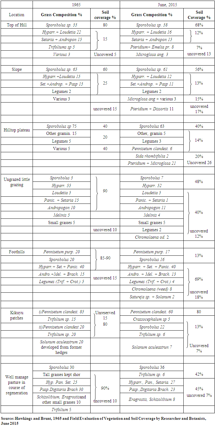
3.2. Variation in Grassland Composition and System Change 1965-2015
Hawkins and Brunt (1965) studied the average situation that was observed in pastures throughout the area. Variation in grassland composition was established according to location; from hilltops, slopes to foot of hill and from ungrazed to well managed pastures in course of regeneration as well as kikuyu patches. Following evaluation of vegetation composition from quadrat derived data, a comparative study and examination was done on the said locations to explore dynamics or the change in vegetation composition and the situation regarding weeds. According to the 1965 study, Sporobolus and Hyperrhenia grasses were the main vegetation on the rangelands of the study and a mix of other shorter grasses and legumes. Table 3 presents the variation in grassland composition as well as the soil coverage in 1965. Moreover, the table presents the current (2015) context of derived grassland variation in composition.Table 3. Variation of Vegetation Composition and Soil Coverage on Grasslands, 1965-2015
 |
| |
|
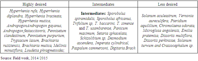
A major change in species or grassland vegetation composition is a conspicuous presence and growth in weeds amongst the grass from the 1965 situation population. The changes in species composition is greatly advantageous to the weeds that are invading grazing areas to the detriment of pastures. A simple picture of the prevailing situation (Table 4) shows a decrease in desirable grass species and a concomitant increase in less desired species. The existing grass species are classified species into desirable species and less desirable species according to pasture quality in the study area.Table 4. Species classification according to desirability
 |
| |
|
3.3. Dynamics in Different Site Vegetation Compositions
3.3.1. Kikuyu Patches
Kikuyu areas have been greatly interspersed with Sporobolus. Pennisetum clandestinum largely occur in association and intermingle with Sporobolus pyramidallis. Around the 1960s Kikuyu grass patches had a dominant stand of over 80% in floral composition. Current trends show a drop to 65% Kikuyu in grass composition. Sporobolus pyramidalis have grown in kikuyu patches and now represent well over 22% while Trifolium and Solanum that used to be associated to P. clandestinum have enormously reduced from over 20% in the 60s to less than 12%. Typical in hilltop plateau areas, the kikuyu grass is in a spectacular combination with Sporobolus and when trampling and grazing becomes intense with the presence of terraces, Pteridium aquililium invasion is high. These invasions are mostly light to moderate with spotted satellite fronts (satellite fronts are spread fronts from individual plant to small plant colonies/patches). Moreover, Kikuyu patches that are not under very intense grazing, or high stocking numbers and with little appreciable management were mostly invaded by short seasonal ephemeral herbs like the case of Crassocephalum sp noticed in the Ndawara area. However, for Pennisetum clandestinum areas, ground cover here remains highest for the study area at over 90-95% like Taashem in Jakiri and Mbamdzeng in Kumbo. Nevertheless, they keep a good range condition and trend but remain sensitive to misuse.
3.3.2. Slopes
Grassland dynamics on slopes is quite eminent with land use. It is worth noting that it is among the most affected sites showing change in floral composition and soil cover. Desired species have greatly diminished, and vegetation is a dominant stand of Sporobolus of over 63% of grassland composition with terraces on slopes. Change in this axis is realized with an increase in weeds among the vegetation composition. Pteridium aquililium, Microglossa angolensis, Dissortis minutiflora and Sida rhombifolia constitute over 20%. Compared to the 1965 situation soil cover has reduced with an associated increase in weeds. Corresponding high level of disturbance is noticed in slopes. Much erosion takes places and a much-reduced percentage of soil cover over 17- 30% is remarked, the worst in all the evaluated sites. Areas with stiff gradients greatly showed a reduction in vegetation cover especially along transhumance routes or tracks used by cattle during the day for watering. A bad range condition is noticed in most slopes especially with gradients of more than 10° (refer figure 17 on weeds and slope gradient) and a downward trend for the tendency. Rills, active gullies and exposed plant crowns and roots mark landscapes within slopes due to poor land use strategies of open range grazing with poor animal distribution. Gullies are noticed when grazing and erosion cause collapse of terraces High gradients in some slopes like in Sabga, Mbokam, Bafmeng, Nkuv presented a much-reduced soil cover (>30%) with weak plant vigour. On slopes at elevations between 1000m and 1300m around Esu, Nyos and Kimbi are Hyparrhenia shrub savannas with association of Chromolaena odorata and Pteridium aquilium at the understory of shrubs. Increase in shrubiness and growth in weeds are major dynamics with Terminalia brownis increasingly noticed in the mist of Hyparrhenia beckeropsis grass in Nyos, Fungom to Weh in Menchum and hills around Mbonso area in Bui division. Slopes are therefore very sensitive to land use and grazing strategies for any given range site and condition ratings qualified most sites as poor with need for better grazing management.
3.3.3. Hilltop Plateau
On hilltop plateau Sporobolus is in steady dominance over 63%. Hyparrhenia is greatly diminished and almost absent. This zone is the most affected by weeds particularly the high lava plateau areas of 1800m and above. It constitutes the greater part of the rainy season grazing area and supports grazing over 240days from April to November all the wet long season. Pteridium aquililium is relatively increased among the floral composition. It is found with a mix of other weeds; Microglossa angolensis in Kukube, with Dissortis multiflora in Ndawara and Binka, with Emilia pratemisa in Tadu, Berlem and Oku. In fact, over 21% of the floral composition in these areas is weeds. Exceptional cases for most affected plateau areas of Tadu, Dzeng-Mbiami i.e. Berlem sites registered cases of over 40% of Pteridium aquililium with dense monospecific stands.Also, the percentage of Loudetia, Setaria, Andropogon, Paspalium is significantly reduced among the vegetal composition. Compared to the 1965 inventory (5% reduction), the present evaluation revealed a reduction of the above species from over 10% to less than 5%, a change that reveals a conspicuous reduction in desired species. Continuous harvest of these desired species without postponement of grazing is causing shifts in species composition with Loudetia simplex especially reduced indicating a downward trend.On the contrary dynamics in top of hill sites saw the conspicuous growth of Microglosa angolensis, Sida rhombifolia especially in areas around the Nyos-Bum stretch and the Lassin-Noni area. Hyparrhenia is significantly reduced from over 22% to less than 15% with a growth of Sporobolus to over 60%. Trifoliums have greatly diminished and are even absent in some top of hill sites but shifts in this species is increasingly being replaced by P. aquililium with associations of Emelia pratemisa. Top of hill sites around Lake Nyos (1118m) were dominated by Sida rhombifolia. Delicate situations are presented for top of mountain range (2900m) with endemic species such as Alchemilla fischeri, Agrostis mannii, Habenaria obovata, and H microceras, Anthospermum aspermuliodes and Vernonia mannii which are under serious threat by goat and sheep rearing. The however, remain key pastures at those altitudes with rangeland considered healthy and warrants a lot of caution in grazing management.
3.3.4. Foothills and Lowlands
Change in foothills and lowlands presents an exotic invader-Chromolaena odorata. This is change below elevations of 1400m especially below 1000m. The floral composition is a Hyparrhenia rufa rangeland with a mix of Pennisetum purpureum, Sporobolus and other species. Change is noticed here with C. odorata invasion with its densities increasing towards disturbance such as road network. Shifts in species distribution of C. odorata in ranges represent contraction in range of some. Distribution changes result in the disruption of biotic interaction of interacting species with important ecological and evolutionary consequences. This is also dependent on co-factors such as dispersal ability. Nevertheless, C. odorata have increased in abundance and breadth of distribution and species richness was dramatically reduced in infested zones. Nonetheless, there are still native stands where relative abundance of Hyparrhenia rufa grass and Loudetia simplex are still high at over 70% of grass composition like the managed rangelands of Dumbo ranch and Kimbi reserves though weeds are taking their turn in road sites and inland valleys.The 1965 situation showed little grazing in foothills but today these are preferred grounds for grazing especially during difficult moments. The increase in C. odorata presence in plant composition is noticeable over 8% in foothills. More interesting is the fact by 1965, the presence of this plant was not yet identified in most locations and 1960s corresponds to the era when the plant was introduced to the area from Nigeria. Adropogon, Melinis, Crotalarias and legumes such as Trifolium constituted over 20% of grass composition during the 60s but now represent less than 13%. Lowland grazing areas like in the Misaje lowlands, NjiniKimbi valley showed noticeable mixture of P. aquililium and C. odorata (8%) in a dominantly Hyparrhenia rufa composition.According to Hawkings and Brunt (1965), by the time of the Fulani arrival in the early half of the 20th century, the whole country was covered with a rather uniform stand in which the thatching grass, Hyparrhenias (mainly H. rufa), strongly dominated. This stand was mixed, depending on the location with Setaria sp. (S. sphacelata), Loudetia and Panicums on the better soils and with Andropogon, Sporobolus, Paspalum and Imperata of medium size on the poorer soils. In both cases, a mixture can still be found in the untouched areas, with Mellinis Mutiflora, Digitaria (spp.) Eragrostis (spp.), Brachiaria and others. The situation described especially for highlands shows that various legumes were abundant, depending on the light the taller grasses would allow. Trifolium baccarini, T. simense and T. usambarense existed as clover and numerous Crotalarias of less interesting value and Desmodium ascendens. Pennisetum purpureum was abundant in wetter situations, and Kikuyu grass (Pennisetum clandestinum) was introduced around Fulani rugas. What is more interesting is the fact that in no case was Sporobolus a conspicuous grass and never was it dominant. The situation for Sporobolus remained same, that of a minor species in places where grazing is not practiced. As established, after a few decades, the whole country has changed, and the grassland is now completely dominated by the Sporobolus pyramidalis especially the highlands. As Hawkings and Brunt (1965) propounded, the phenomenon requires some explanations.Species preferences of grazing animals, resistance to continuous grazing as well as ecological suitability of the high plateau area are amongst the clarifications. Incessantly grazed and suppressed due to its palatability, Hyparrhenia sp the dominant grass has enormously reduced within the grass population in the high plateau area. As it is noted, Hyparrhenia like most perennials withstands burning but does not support continuous stocking with uninterrupted harvest or grazing. It is very palatable when young and remains so until a height of 1meter is attained. Sporobolus on the other hand after heights of 30-35cms no longer remains palatable due to its coarse fibrous tufts. Animals graze every young shoot but have the tendency to leave the Sporobolus on account of its hard leaves. As such, it is protected and the remainder of the sward is eaten by cattle. Off course grazed and re-grazed, the best species unable to stand this treatment finally disappear. As soon as the other grasses have started to rarify, the cattle despising the Sporobulus, walk increasing distances to find what they like. This is a typical characteristic behavior of open communal rangeland grazing. Also, Sporobulus do not only withstands trampling but even seem to do well under it. On the slopes, trampling is so marked creating terraces of 30-50cms wide, the edge being occupied by Sporobolus with a few other small grasses and legumes, the path itself being almost bare. Overall loss of vegetation under combine grazing pressure and annual rangeland burning creates more vulnerability to erosion and weed invasion.Today within Sporobolus landscapes, it is these bare terraces that are largely invaded by Pteridium aquililium in the upland plateau grazing areas. In some areas in the present context, Sporobolus accounts for over 80% of the grass composition where it is found in pure stands and free of weeds. But the situation particularly in upland plateau areas has greatly been dwindled with the upsurge of Pteridium weed. As such, obviously established has been the gradual reduction of Hyparrhenias in highland plateau areas and the transition to Sporobolus covered landscapes. These landscapes are more vulnerable to weed invasion due to continuous stocking that increasingly create the bare terraces, rarify palatable species and offer suitable conditions for weeds to invade. However, species composition and percentage of weed presence in highland plateau depends on patch density; dense, moderate, or light (sparse). Table 5a and 5b derives the average percentage of weed presence according to patch density in the study area obtained and characterized from field evaluation. Spatial distribution of weed density is presented in figures.Table 5a. Patch density and percentage of weeds in grass composition
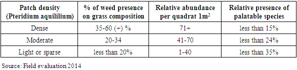 |
| |
|
Table 5b. Slopes aspects, weed presence and presence of palatable species
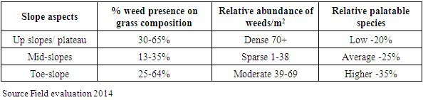 |
| |
|
Weed invasions in the humid tropics especially in rangelands are a major challenge to rangeland management. There is very little history of weed mapping and socio-economic and ecological implications in Sub-Saharan Africa. On no occasion was bracken fern a dominant plant in grass composition (Hawkings and Brunt, 1965), while C. odorata was only introduced in Cameroon from the 1970s (Youta, 1996, Mairomi, 2016). Bestelmeyer et al (2006) notes that land use affects state and transitions for plants in rangeland. Schneider (2005) not that spatial distribution of invasions involves more complex processes of land use strategies, land degradation and fire regimes. Lambi and Ndenecho (2010) purports that the ecology of natural resources (rangeland) in the western highlands of Cameroon are affected by resource use practices of varying intensities. This work went beyond this land use practices to map invasions and look at changes within grass association resulting from weed invasions. This study derived the following key lessons, 1) Two key invaders are recurrent in the western highlands-Pteridium aquililium in the highlands especially plateau summits (Bui and Donga mantung) and C. odorata an exotic in the lower altitudes below 1000m (Menchum, Misaje lowlands) 2) More than 52% of rangelands are weed invaded while weed patch density varied across landscape being light, moderate to dense with different implications in pasture reduction as well on slope from top, mid to toe slopes. 3) Palatable species stood at -35% for light infestation, -24% for moderate infestation and -15% for dense invasions showing major shifts in species notably legumes. 4) Land use practices including grazing and fire are very related to weed expansions. Nevertheless, pastoralists and institutions are making modest efforts to contain spread which are still very limited but the change in plant composition with invasion is steady and warrants more efforts from different stakeholders involved in rangeland management to tackle weed invasions.
4. Conclusions
Pteridium aquililium, Chromolaena odorata, microglossa angolensis, sida rhombiforlia are amongst the major weeds that require efficient management to contain, and limit spread to clean areas. Pteridium aquililium was characterised to be an altitudinal invader with over 22% in grass composition and even over 50% in some plateau areas above 1500m. C. odorata was situated in low altitude zones below 1200m with average composition about 20% in high density areas. It’s worth noting that a significant difference in C. odorata abundance exists between intense risks zones (rangeland fragmentation or croplands, roads, streams) and other further rangeland zones. In fact, besides grazing as a disturbance, cropland within range and streams, proximity to roads in particular projected greater higher relative levels of abundance and therefore an indicator of a strong correlation between risks and spread corridors.Pastoral land tenure requires laws that are workable, inclusive and adapted to local values. Rangeland improvement and integration can be sought for a broad-base poverty reduction and livelihood improvement, sustainable management and better community integration. Due to lack of complementary data on weed species, research can track the evolving landscapes to assess and provide accurate environmental data that can help formulate rational decisions on weed management. Apart from grazing, rangelands here sustain large dynamic ecosystems supporting varied wildlife and domestic livestock. However, productivity and long-term economic viability of grazing activities is undermined and threatened by growing pockets of unwanted unpalatable vegetation (weeds) at the expense of a pastures. As such, research can focus on how community-based approaches can be used to manage weeds and improve rangelands.
ACKNOWLEDGEMENTS
This research was conducted in partial fulfilment of requirements for PhD dissertation submitted by Harry Mairomi in the department of Geography at the University of Yaounde 1 in Cameroon.
Disclosure
This section is ONLY for those who requested disclosure. The name of the experts that reviewed your paper, in case they accepted selling disclosure to you, will appear here. Each reviewer is allowed to make their own price for that, since that is a public endorsement of your findings and may be used for varied purposes.
References
| [1] | Austin, M. 2007. Species distribution models and ecological theory: a critical assessment and some possible new approaches. Ecological Modelling 200: 1–19. |
| [2] | Bestelmeyer, B.T., Brown, J. E., Havstad, K. M., Alexander, R., Chavez, G., and Herrick, J. E. 2003. Development and use of state-and-transition models for rangelands. Journal of Range Management 56: 114-126. |
| [3] | Bethany, A. B. and Mustard, J. F. (2006). Characterizing the Landscape Dynamics of an Invasive Plant and Risk of Invasion Using Remote Sensing. Ecological Applications 16(3): 1132-1147. |
| [4] | Boutrais, J. (1983): L’Elevage Soudanien. Des Parcours de savanes aux ranchs (Cameroun-Nigeria). ORSTOM, No 160, Edition de l’Office de la Recherche scientifique et Technique Outre-Mer, 148p. |
| [5] | Hawkins, P. and Brunt M. (1965): Soils and ecology of West Cameroon. Vols. I & II, FAO Expanded Programme of Technical Assistance No. 2038, FAO, Rome. 508p. |
| [6] | HEIFER Project International, Cameroon. 2001. Annual Report, Sharing Livestock, Serving Cameroon, Gospel Press, Bamenda, 31p. |
| [7] | Letouzey, R. (1968): Etude phytogeographique du Cameroun, Ve edition, Paris, Pub Paul Lechavalier. 508p. |
| [8] | Lambi, C.M. and Ndenecho, E. N. (2010): Ecology and Natural Resource Development in the Western Highlands of Cameroon. Issues in Natural Resource Development. Langaa Research and Publishing Common Initiative Group; PO Box 902 Bamenda. 135p. |
| [9] | Schneider, L. C. (2005) Invasive Species and Common property: The case of bracken fern (Pteridium aquilinum (L.) Kuhn) invasion in the region of Calakmul. Environmental Change Initiative, Theme for the conference: Environmental services and common resources. Brown University. 24p. |
| [10] | Mairomi, H. W. (2012). Human Encroachment into Grazing and Rangelands; A Case Study of Rangeland Improvements in Jakiri Sub-Division. Masters dissertation, Department of Geography, University of Yaounde I, 179p. |
| [11] | Mairomi H. W. (2016): Weed infestation in Rangelands of the Grassfields, Tracking System Dynamism in the North West Region of Cameroon. PhD thesis, Geography Department, University of Yaounde I. 376p. |
| [12] | McINTYRE, J., Bourzat and Pingali, P. (1993): Crop livestock interaction in sub-Saharan Africa: regional and sectoral studies series. The World Bank, Washington DC. |
| [13] | Mercier, L. (2009). Study of Sylvopastoralism in the Mbororo community in the North West Region of Cameroon. Masters dissertation, ISLA University, Belgium 77p. |
| [14] | MINEPIA, Ministry of Livestock, Fisheries and Animal Industries. 2013. Quarterly Report of Activities from 1st October to 31st December 2013. Divisional Delegation Bui, MINEPIA. |
| [15] | Ndenecho, E. N. (2005): Biological Resource Exploitation in Cameroon; From Crisis to Sustainable Management. Unique Printers Bamenda pp101-130. |
| [16] | Ndenecho, E. N. (2006): Mountain Geography and Resource Conservation; Sustaining Mountain Environments and Rural Livelihoods in Bamenda Highlands, Cameroon. Unique Printers Bamenda 184p. |
| [17] | Ndzeidze S. K. (2004): socio-economic and Ecological implications of related land use practices on wetlands in the Ndop flood plain drainage Basin-Upper Noun Valley-Cameroon. DEA dissertation, Department of Geography, University of Yaounde I, 98p. |
| [18] | Ndzi, V. N. (2008): Agrostology, National Centre for Animal Husbandry Veterinary and Halieutique Training (CNFZVH) Jakiri 52p. |
| [19] | Ngane, E. B., Ngane, B. K., Ndjib, G., Awah, E. T. and Ehabe E. E. (2012). Land consumption and related degradation patterns by major agricultural uses in the humid tropical Savannah of North West Cameroon. Institute of Agricultural Research for development (IRAD), Ekona Regional Agricultural Research Centre, PMB 25 Buea, Cameroon. Agricultural Science Research Journal Vol. 2(6) pp. 318-323. |
| [20] | Ngwa, E. N. (1985): Innovation Agencies and small holder Agriculture in the Noun Basin and its environs: “A River Basin Approach”. Doctorate Thesis, university of Yaoundé 574p. |
| [21] | Norgrove, L., Julia, D., and Fuambeng P. (2014): Changes in ecosystem functions in savannahs and fields invaded by Chromolaena odorata in Cameroon. file:///D:/PDFs/chromo%20odorata%20north%20west.pdf. |
| [22] | Pakeman, R. J., and Marrs, R. H (1992): The Conservation Value of Bracken Pteridium aquilinum (L. Kuhn-Dominated Communities in the UK, and an Assessment of the Ecological Impact of Bracken Expansion or Its Removal. Biological Conservation 62 (2): 101-114. |
| [23] | Pamo, E. T., Yonkeu, S., Onana, J., and Rippstein, G. (1998). Evaluation de quelque especes fourrageres locales du domaine soudanien Camerounais. Sceince Agronome & Development: 1:19-25. |
| [24] | Reed, R. A., J. Johnson-Barnard, and W. L. Baker. 1996. Contribution of roads to forest. |
| [25] | Fragmentation in the Rocky Mountains. Conservation Biology 10:1098-1106. |
| [26] | SNV-MBOSCUDA (2008). Report of Workshop on Dialogue platform and between resource users, access and management of pastoral resources in Ngoketunjia Division. 48p. |
| [27] | Vabi, M. B. (1993). Fulani settlement in the North west Province of Cameroon. ODI Pastoral Development Network paper No. 35p. |
| [28] | Vabi, M. B. (2003). Social relationships between indigenous cultivation and Fulani grazers in the derived savannah of Southwestern Nigeria and North West Province of Cameroon, University of Ibadan, Nigeria, pp 45-83. |

 Abstract
 Reference
 Full-Text PDF
 Full-text HTML