-
Paper Information
- Paper Submission
-
Journal Information
- About This Journal
- Editorial Board
- Current Issue
- Archive
- Author Guidelines
- Contact Us
International Journal of Ecosystem
p-ISSN: 2165-8889 e-ISSN: 2165-8919
2021; 11(1): 1-7
doi:10.5923/j.ije.20211101.01
Received: Dec. 3, 2020; Accepted: Jan. 6, 2021; Published: Jan. 15, 2021

Analysis of Changes in Mangrove Forest Cover in Kabaena Island, Bombana Regency
 Abstract
 Reference
 Full-Text PDF
 Full-text HTML
La Baco Sudia1, Nur Arafah2, Abdul Manan1, Kahirun1, Sahindomi Bana2, Zulkarnain2
1Department Environmental Science, Faculty of Forestry and Environmental Sciences, Halu Oleo University, Kendari
2Department of Forestry, Faculty of Forestry and Environmental Sciences, Halu Oleo University, Kendari
Correspondence to: Sahindomi Bana, Department of Forestry, Faculty of Forestry and Environmental Sciences, Halu Oleo University, Kendari.
| Email: |  |
Copyright © 2021 The Author(s). Published by Scientific & Academic Publishing.
This work is licensed under the Creative Commons Attribution International License (CC BY).
http://creativecommons.org/licenses/by/4.0/

The Area of mangrove forests on Kabaena Island is estimated to continue to decrease from year to year, this is due to land use by the community. These uses are in the form of logging for firewood, fragmentation and conversion to other forms of use. Logging/clearing of mangrove forests can disturb other natural resources. This study aims to determine changes in forest cover and the level of degradation in mangrove forest areas on Kabaena Island from 2000 to 2020. Pre-processing stages consist of 2 stages, that is geometric correction and radiometric correction. Geometric corrections are carried out to transform the Landsat image so that it has characteristics in shape, scale and projection. Geometry transformation is carried out to reposition the pixel position in such a way that the image is transformed and the recorded object image can be seen clearly. Visual Interpretation of Image Visual, interpretation is carried out on images to recognize the spatial characteristics of objects. Characteristics of objects can be recognized based on 9 elements of interpretation, that is shape, size, pattern, shadow, hue/color, texture, site, association and convergence of evidence. Analysis of mangrove forest cover data was carried out by identifying the shape of object changes in satellite imagery at the research location. Landsat imagery interpretation to identify land uses for 2000, 2005, 2010, 2015 and 2020 was done visually. The validation of the identification results of the field conditions is based on the results of the accuracy test. The land use classification accuracy test is performed statistically by calculating the overall accuracy based on the confusion matrix and Kappa accuracy. Accuracy is in the high category if it is 0.81-1.00. Results showed that during the period 2000 to 2020 there had been a decrease in the area of mangrove forests on Kabaena Island by 275,03 hectares.
Keywords: Kabaena Island, Mangrove Forests, Change in Mangrove Forest Cover
Cite this paper: La Baco Sudia, Nur Arafah, Abdul Manan, Kahirun, Sahindomi Bana, Zulkarnain, Analysis of Changes in Mangrove Forest Cover in Kabaena Island, Bombana Regency, International Journal of Ecosystem, Vol. 11 No. 1, 2021, pp. 1-7. doi: 10.5923/j.ije.20211101.01.
Article Outline
1. Introduction
- Indonesia's territory which is mostly located in coastal areas, is facing rapid land use change as development is growing. The coastal area is a very vulnerable area due to shifting of the coastline towards the mainland, sedimentation, logging of mangrove forests, coastal reclamation, the entry of garbage and hazardous materials into the sea through river estuaries. This phenomenon also occurs on Kabaena Island which is one of the islands located in the coastal area. Kabaena Island is an island located in Southeast Sulawesi Province and is part of the division area of Bombana Regency with Kasipute as the capital of its government.The socio-economic conditions of Kabaena Island generally have 2 livelihoods, that is fishermen and farmers. In the coastal area of the island of Kabaena, settlements and various other community activity centers have grown and developed. The existence of coastal areas is an integral part of community activities along the coast. This is an integrated ecosystem that is interrelated so that it will cause changes in the land area in the coastal area of Kabaena Island, especially the area of mangrove forest.The area of mangrove forests in Indonesia reaches 3.49 million hectares, but 52% or 1.82 million hectares of Indonesian mangroves are in a damaged condition [1]. Indonesia has a tropical climate with high rainfall and most of the waters are relatively calm, so it becomes a suitable place for mangrove growth and development. Indonesia has many mangrove types and areas of mangrove areas that are scattered throughout the province so that it holds the title of the widest.Indonesia's mangrove forest play a significant role in national and global climate change mitigation strategies. In the last three decades, Indonesia has lost 40% of mangrove forest [2]. This means that Indonesia has the fastest rate of mangrove forest destruction in the world [3]. Mangrove forests support a broad spectrum of ecosystem services. Mangrove forests provide an important defense against coastal erosion. Roots bind the soil and alter water flow, preventing the loss of sediment from shorelines [4]. Mangrove forests help reduce the impact of storm surges, big waves and wind gusts from tropical cyclones. Mangrove trees reduce wave energy as they pass through the mangrove forest, and act as a barrier between waves and land [4,5].It is estimated that until now, the area of mangrove forests on Kabaena Island continues to decrease from year to year, this is due to land use by the local community. These uses are in the form of logging for firewood, fragmentation and conversion to other forms of use. Logging / clearing of mangrove forests can disturb other natural resources. If the deforestation of mangrove forests occurs continuously, it will threaten flora and fauna species and damage people's livelihoods [6,7].Mangrove forest management requires the support of accurate data and information. Currently, by utilizing the technological capabilities of the Geographical Information System (GIS) and remote sensing, data and information on the extent and cover of mangroves on Kabaena Island can be processed more efficiently. Remote sensing can be used in monitoring mangrove vegetation, this is based on two important characteristics, namely that mangroves have green leaves (chlorophyll) and mangroves grow on the coast. The optical property of chlorophyll is very distinctive, namely that chlorophyll absorbs the red light spectrum and reflects strongly on the green spectrum. This study aims to determine changes in forest cover and the level of degradation in mangrove forest areas on Kabaena Island from 2000 to 2020.
2. Methods
- This research was conducted from October to November 2020. The research location was in the Kabaena Island Mangrove Forest, Bombana Regency, Southeast Sulawesi. The research location can be seen in Figure 1.
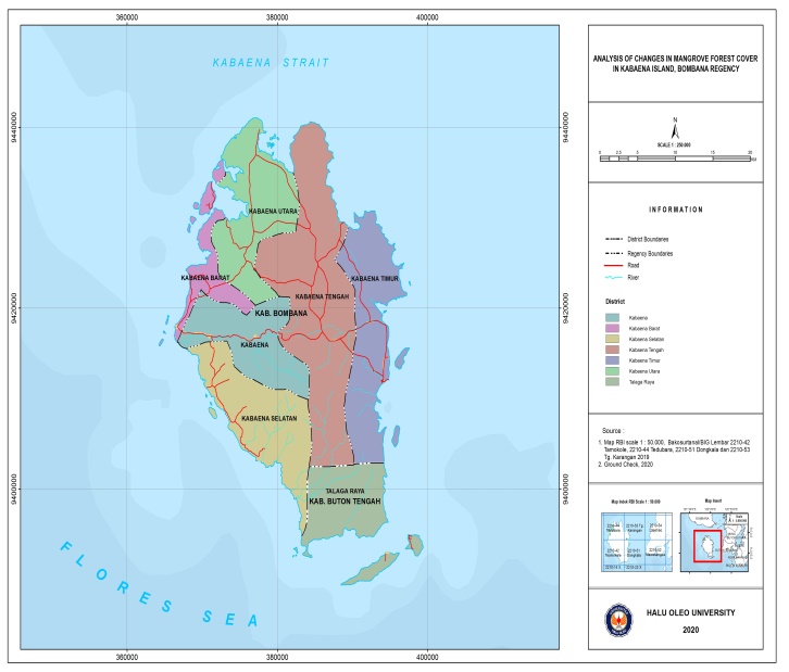 | Figure 1. Study Area |
 Information:xi + = Number of reference pixels in the ith land usexii = The number of reference pixels on the ith land use that correspond to the –iN = Total number of reference pixelsKhat = accuracy value KappaAccuracy is in the high category if it is 0.81-1.00Identification of Changes in Mangrove Forest CoverThe map of mangrove forest cover resulting from image interpretation is used to identify changes in classified mangrove forest cover between 2000, 2005, 2010, 2015 and 2020. The technique used is guided classification. The results of identification of changes in mangrove forest cover are displayed in the form of a matrix of changes in mangrove forest cover.
3. Results
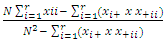
3.1. Field Inspection
- In this study, checks were carried out at 75 points in the field. The following shows several check points in the field in Figure 2.
 | Figure 2. Several Points field inspection |
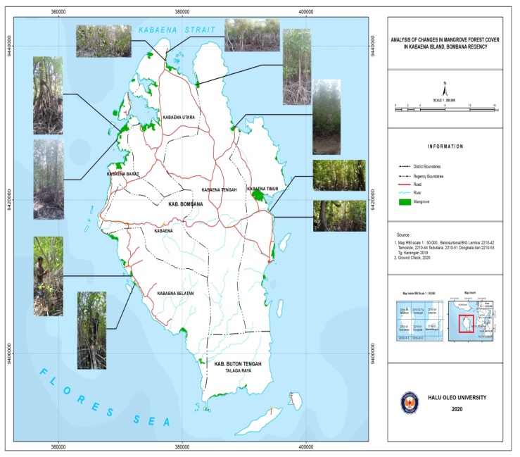
3.2. Mangrove Forest Area from 2000 to 2010
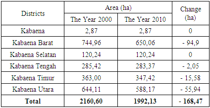
- The results of interpretation of Landsat 5 imagery in 2000 and 2010, obtained data on the area of mangroves forest for each district on the island of Kabaena. More clearly can be seen in Figure 3 and Table 1.
 | Figure 3. Kabaena Island Mangrove Forest Cover in 2000 and 2010 |
|
3.3. Mangrove Forest Area from 2010 to 2020
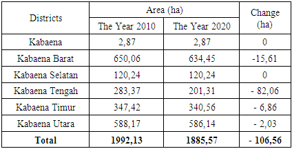
- The results of interpretation of Landsat 5 and Landsat 8 imagery from 2010 and 2020, obtained data the area of mangroves forest for each district on the island of Kabaena. More clearly can be seen in Figure 4 and Table 2.
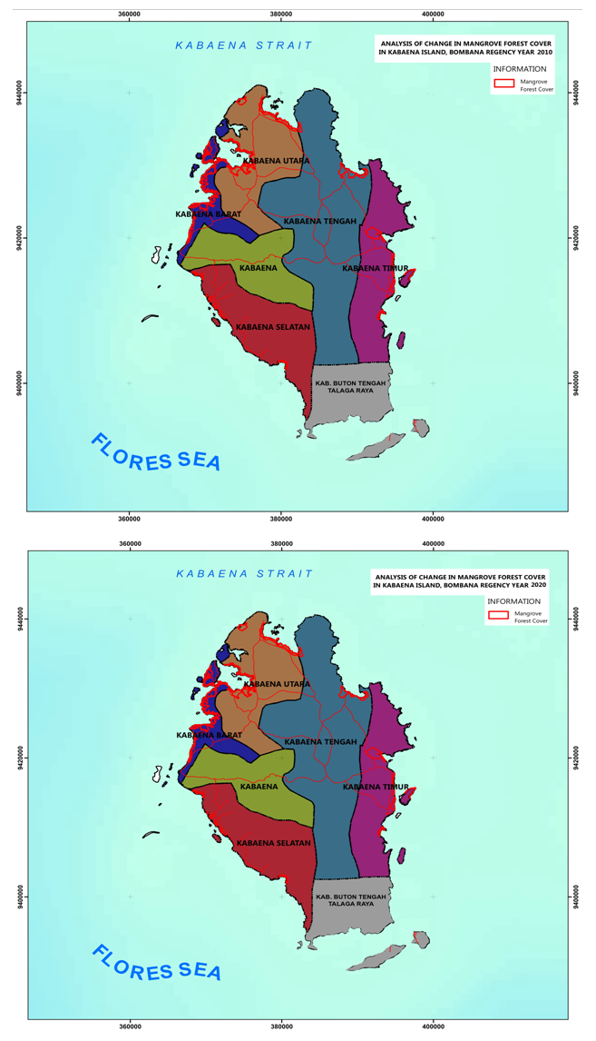 | Figure 4. Kabaena Island Mangrove Forest Cover in 2010 and 2020 |
|
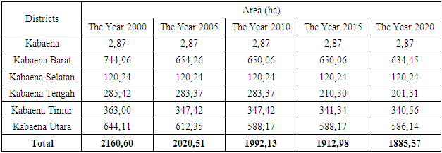
3.4. Mangrove Forest Area from 2000 to 2020
- The results of image interpretation in 2000, 2005, 2010, 2015 and 2020, obtained data on the area of mangroves forest for each district on the Kabaena island. It can be seen that there has been a decrease in the area of mangrove forest in the last 20 years. More clearly can be seen in Figure 5 and Table 3.
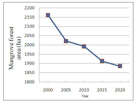 | Figure 5. Graph of changes in mangrove forest area for 20 years |
|
4. Discussion
- Based on the results data above, it is known that overall there has been a decrease in the area of mangrove forest that has occurred during the last 20 years (2000 to 2010) covering an area of 275,03 ha. The largest decrease in area occurred in Kabaena Barat and Kabaena Tengah Districts. Based on the results of surveys and interviews conducted in the field, information was obtained on some of the main causes of mangrove forest degradation in the study location, namely conversion of mangrove forests to ponds, logging for timber utilization and for settlement. Research [11,12,13] explains that the cause of the reduction in mangrove forests is because pond development activities are carried out through mangrove forest conversion activities. In line with [14,15,16,17] that community activities such as aquaculture and illegal logging which are used as firewood and building materials cause mangrove forest damage. Research [14,18,19] stated that the level of damage to mangrove forests is increasing every year due to the construction of settlements, ports, and aquaculture. Areas that did not experience wide change were Kabaena and Kabaena Selatan Districts. This is probably due to natural factors, given the long study period of 20 years. Within five years of recovery, mangrove growth is seen to be significantly higher [20]. Research [21] stated that from time to time the mangrove seedlings would grow bigger so that the mangrove seeds that were originally planted with a sparse density would become medium and dense. Protection and reforestation measures are driving the restoration of mangrove forests very rapidly [22].The reduced area of mangrove forests that occurs will have an impact on the surrounding environmental conditions. This is because mangrove forests have an important role in environmental balance. Mangrove forests have various roles, such as providing protection and supplying organic matter as food for aquatic biota such as various types of fish, shrimp and mollusks [23,24,25,26,27], protection against currents and waves ocean [5,28,29], store larger average carbon per hectare of terrestrial tropical forest [30,31,32,33] and play a role in the socio-economy of communities [23,34,35]. Therefore, efforts are needed to maintain the remaining mangrove forests as well as efforts to improve them through rehabilitation or replanting of mangroves, especially in sub-districts where the mangrove forest area is lost. B. Utomo [36] explained that the rehabilitation of mangrove forests in addition to increasing forest area also has an impact on increasing salt / fish production, decreasing coastal abrasion, being able to withstand winds from the sea, increasing the catch of biota and becoming a tourist attraction. Artificial planting has a stronger positive effect on the survival of mangroves and increases the growth of these mangroves [37].
5. Conclusions
- The results of the study concluded that during the period 2000 to 2020 there had been a decrease in the area of mangrove forests on Kabaena Island by 275,03 ha, which was generally caused by conversion to ponds, logging for timber utilization and for settlement. The largest decrease in mangrove forest area occurred in Kabaena Barat Subdistrict, amounting to 110,50 ha and Kabaena Tengah with 84,11 ha.
ACKNOWLEDGEMENTS
- Thanks to the Institution for Research and Community Service, Halu Oleo University, for financial this research through the UHO DIPA Fund 2020.