Fereshteh Habib1, Farideh Atabi2, Hassanali Laghaei2, Hossein Mousavi Fatemi2, Kimia Janfada2
1Department of Art and Architecture, Science and Research Branch, Islamic Azad University, Tehran, Iran
2Department of Environment and Energy, Science and Research Branch, Islamic Azad University, Tehran, Iran
Correspondence to: Kimia Janfada, Department of Environment and Energy, Science and Research Branch, Islamic Azad University, Tehran, Iran.
| Email: |  |
Copyright © 2014 Scientific & Academic Publishing. All Rights Reserved.
Abstract
Given the large number of tourists, Darakeh is considered as one of the most important tourism resort in Tehran City. Limited natural reservoirs in mountainous areas should be managed appropriately in order to avoid deteriorating of natural equilibrium. The present study aims at designing of a nature park in northern Tehran. For this purpose, a variety of map layers including slope, aspect, elevation, accessibilities, land cover, land uses, facilities, constraints, and landscape were prepared using GIS. Subsequently, according to literature reviews, a conceptual model was presented based on sustainable development principals using SWOT. According to the results, southern slope of Alborz Mountain is a suitable place for development of mountainous nature park in northern Tehran.
Keywords:
Nature park, Tourism, Urban planning, Darakeh, Tehran City
Cite this paper: Fereshteh Habib, Farideh Atabi, Hassanali Laghaei, Hossein Mousavi Fatemi, Kimia Janfada, Design of Dareh-Darakeh Nature Park for Ecotourism Development in Tehran Metropolitan City, International Journal of Ecosystem, Vol. 4 No. 5, 2014, pp. 224-232. doi: 10.5923/j.ije.20140405.03.
1. Introduction
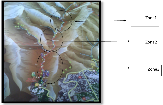
Urban open space is of utmost importance for social interactions and for protection of future generation rights. Obviously, coordinating natural and man-made structures requires identifying environmental carrying capacity and determining zones suitable for recreational purposes [1-4]. This makes possible the most appropriate permissible use of national parks in consistent with the stability and survival of these places [5, 6]. Therefore, resources remain without deterioration for future generations [7, 8]. From modern ecological viewpoint, national park or river-valley ecosystem is a part of the space on the ground that meets a specific arrangement of topography, land cover, hydrography, and built environment. This space is called landscape. In this viewpoint, the landscape is composed of groups of ecosystems or spatial units influencing each other throughout which a similar form is repeated [9]. According to Forman & Gordon (1986) landscape elements include one patch or 2 corridors. The patches are considered as an ecosystem or a biogoecenose. Patches form an ecological mosaic. Due to the role of valleys as "patch - corridor" in the ground structure, in the present study, patches and corridors were used as structures to achieve sustainability. The output will be applied as a suitable model for designing other valleys. The slopes of Alborz Mountain Range as a main origin for establishment of Tehran City provide the citizens with tourist resorts. Unsustainable development regardless of environmental considerations in Tehran in the last three decades has led to degradation of mountain ecosystem in the northern Tehran and its surrounding plains. Considering that mountains are natural heritage and a vital source of water supply, their conservation must be the responsibility of all society members [10, 11]. Currently, lack of an appropriate model for referrals to the mountains has caused all reception and service units located in the mountains be considered as a destructive factor of the nature. According to the relevant laws, development of Tehran City is illegal at altitudes higher than 1800 m. Tehran Master Plan, adopted in 2006, highly emphasis on the importance and necessity of maintaining and developing river-valleys in Tehran as a respiratory lung of the city. In the meanwhile, one of the main valleys in northern Tehran is Darakeh in District 1 of Tehran City. The main objective of this research is to provide a healthy environment in the Darakeh Valley based on the existing ecological capabilities and to reorganize the mountain environment in a way to slow down or even stop deterioration of the natural ecosystem. Figure 1 demonstrates importance of Tehran's river-valleys in Tehran Master Plan. River- valleys in the figure are marked with arrows. Due to the role of mountains in people's life and vulnerability of mountain regions, there has been much discussion on "Sustainable mountain development" among which can be pointed to the United Nations Conference on "Environment and Development" [12]. Agenda 21 is the main achievement of this summit in which Chapter 13 is devoted to the sustainable management and development of mountain areas. 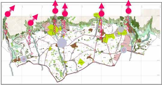 | Figure 1. River-Valleys of Tehran (Tehran.ir website) |
Mountain Conference was held nine decades ago as a result of Earth Summit in Rio. Among the summit achievements can be pointed to "International Partnership of Mountains and Global Change”. One can also mention the date of December 11 as "International Mountain Day" and the organization is called "International Cooperation for Sustainable Development in Mountain Areas." The idea of park designing dates back to 1917 when creation of "national parks" was raised. It emphasized to the point that parks should be maintained in a way to remain without degradation for recreational use of future generations. In order to achieve design criteria of mountain parks, similar templates in the world and in Iran are mentioned here. Among sustainable parks can be pointed to Banff Mountain Park (part of the Rocky Mountains) in Canada. The park is Canada's first mountain park, which was established in 1885. The park was designed in compliance with the ecological considerations. By protecting the park, it would be maintained at least for the next 150 years. Another example is Kittatinny Valley State Park located near Andover, New Jersey. Glacial lakes and limestone outcroppings are just some of the features of the park. Northern valleys overlooking Tehran had initially a rural fabric and a good climate, which have gradually led to urban development. Since natural capabilities have not been observed in urban development, all factors causing an economic boom such as weather and access to natural resources have gradually disappeared and replaced by urban constructions [13]. For instance, the design of Farahzad and Kolakchal parks is examined here to detect factors affecting the mountain environment. In recent years, the rout of Farahzad River - Valley (adjacent to Hemmat Highway) was designed to conserve the watercourse and its high walls (Atak Consulting Engineers, 2004). The design of such an environment considered as one of the corridors of Tehran has some drawbacks including loss of communication between the river-valley downstream and upstream areas. Asphalt pavement of the natural riverbed and allocation of a small area surface watercourse can be a great risk against seasonal flooding in Tehran. A suitable resort can be established in the region considering environmental and security considerations [13]. Jamshidieh Park is located on the northern Tehran in the vicinity of the valleys Gelaidare and Kolakchal. Among the criteria were met in the design of this park can be pointed to sustainability, conformity with the nature, respecting the hierarchy of city to mountain, variation in spatial design, paying attention to natural features and constraints, savings in the use of natural materials, and the use of native plants [14]. By comparing similar templates, a series of criteria can be shortlisted for sustainable design of mountain parks including maximum use of indigenous plants and materials, compliance with ecological principles, establishment of security in parks, and integrated management. The implementation of such principles ensures sustainable architecture in the region. The purpose of this study is to design one of the main river-valleys in Tehran (located in District 1) using a nature-based approach. In this study, the site features and constraints were identified and evaluated using GIS. Given the design principles of mountain parks, the land uses necessary for development of the site were determined. Afterwards, the land uses were allocated in a way to minimize deterioration of the natural environment.
2. Materials and Method
In the current study, planning and designing of Dareh-Darakeh Mountain Park was performed using GIS. Accordingly, the designing principles of the mountain park were determined, initially. Alongside, the designing process of several mountain parks in Iran and in the world was studied to shortlist the most important principles for the design of mountainous nature parks. In the next step, the geographic characteristics of the study area were identified. Subsequently, the maps of the facilities and constraints of the site were prepared. Using field studies, vision and landscape map of the site was prepared by overlaying of criteria map layers. According to the designing principles of the mountain parks and nature parks, appropriate land uses of the site were selected. Then, a schematic of allocated land uses and their communications was prepared. These areas were designed based on the present status of the study area as well as principles for a sustainable landscape.Recreational site District 1 situated in northern Tehran has always been the center of attention in terms of topography and climate. Dareh-Darakeh River extending along the north-south direction is bordered by Shahneshin and Tochal altitudes on north, by Velenjak River and Aliabad hills on the east, by altitudes overlooking Hesarak and Kan River basin on the west, and by Evin and Saadatabad on the south. It has an area of 2420 ha with an average height of about 3900 m. The average slope of the lands is about 40%. The length of the river is approximately 9 km. The riverbed slope is about 5.5% on average. The riverbed width varies from 7m to 60m at different cross-sections while its depth ranges between 4m to 8 m. Darakeh is one of the most popular river valleys in District 1 of Tehran Municipality. Natural features such as mountainous landscape and natural attractions are among the factors distinguishing the area from other valleys in northern Tehran. Figure 2 illustrates situation of Dareh-Darakeh River.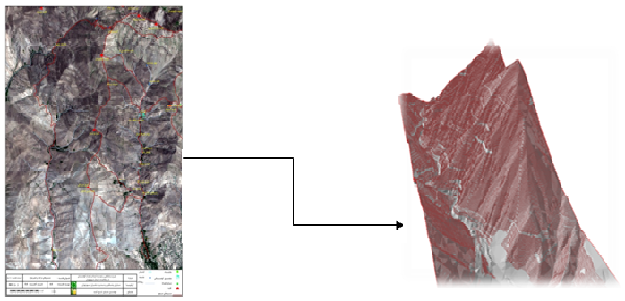 | Figure 2. Dareh-Darakeh River Basin |
Study areaSlope and aspect classifications The slope and aspect parameters have a significant impact on land cover, soil moisture retention, and locating park applications. Contour lines on the topographic map were used to prepare the aspect map of the study area [15]. The average slope in the study area is 40%. A large part of the study area extends along southern and north-eastern slopes. Geomorphology Geo-morphological status of the study area results from geological activities in the Alborz and Central Plateau. Thin topsoil together with grained-sandstone and crushed-stone chips in the riverside is due to the natural erosion in the study area. At highlands (ranges from 2500 m to 3400 m), there are distributed soft soil along springs and a variety of shrubs and forage plants. In this area, outcrops are covered with volcanic ash and the stones such as clay, limestone, stratified clay, sand, and conglomerate, known as lithosol and regosol [16]. Surface water The most important surface water source in the study area is Darakeh River. The river fed by springs and seasonal rivers has appropriate water discharge all through the year, which is consumed mainly for irrigation of gardens in Evin and Darakeh region. The drainage system in the region includes a main section and some subsidiary parts. The main section located in the centre discharges a large volume of surface water outside the study area. It originates from the main ridge in east-west direction, and, after joining the tributaries, is discharged to the Darakeh River. The drainage water enters Evin Valley and flows outside the area. Remaining surface water is discharged from eastern and western parts through Farahzad Glen in the west and Kareh-Delvaz Valley in the east.Fauna and flora The land cover in the study area has a medium density with a discontinuity in some places. It is distinguished as a riverside strip alongside the Darakeh River. Woody and gross plants include the majority of the plant species in the study area. Situating a part of the site in Central Alborz Protected Area provides great potentials for wildlife reproduction and growth. Considering the necessity of proper interaction between humans and wildlife, the impacts of development activities on wildlife habitats are to be assessed [16].
3. Result and Discussion
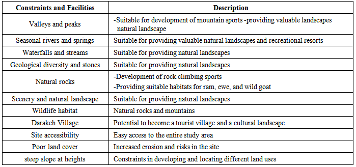
In this research, map layers were overlaid considering the facilities and resources available in the site. Facilities and constraints of the site are briefly listed in Table 1. Besides; Figure 3 shows constraints and facilities of the site.Table 1. Constraints and facilities of the site
 |
| |
|
 | Figure 3. Facilities and constraints of the site |
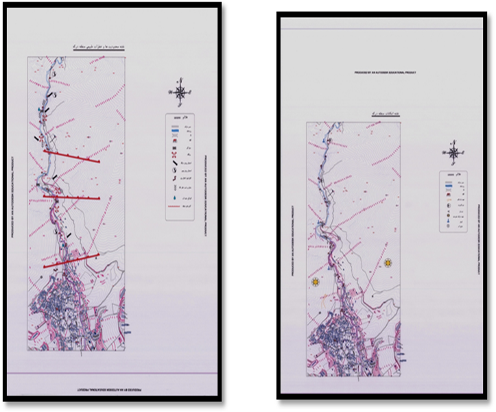
Site zoning The site was zoned regarding the constraints and facilities. The site was divided into three zones demonstrated in Figure 4. The attributes of the zones are listed in Table 2. 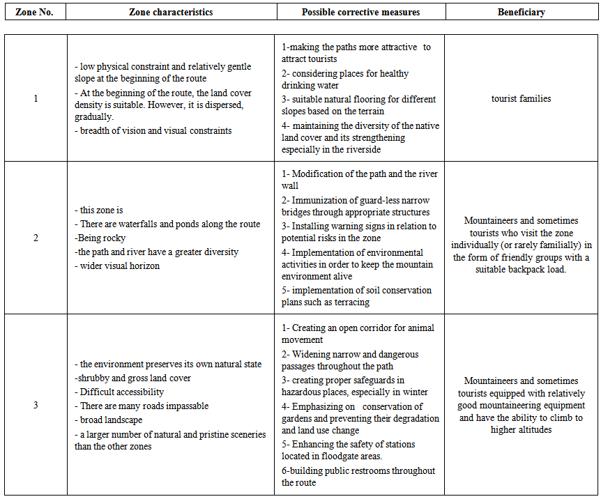 | Table 2. Zones considered for the site |
 | Figure 4. Zoning map of the site |
First part: recreational zone This zone includes Darakeh Crossroads situated before the Kara Spring. the elevation of the zone ranges between 1684m and 1889 m. The route length is 2.6 km. There is a subsidiary route before the Kara Restaurant towards west direction that ultimately reaches the Kara Forest. The path length is 1.1 km. Second part: mountaineering zoneThis zone includes a mountaineering path covering an area between Kara Spring to and Azghal Chal Spring at the height of 2110 m. The path length is 1.8 km.Third part: climbing zoneThis zone begins from Azghal-chal Spring at a height of 2110 m and ends in Palang-chal Wildlife Refuge at the height of 2441 m. The path is 1.2 km in length. There are wonderful, beautiful landscapes such as waterfalls throughout the route. Principles for sustainable site planning “use of indigenous plants and materials”, “use of the surface water and seasonal rivers”, “architectural use of the land cover”, “use of advance technologies”, “designing based on the contour lines”, “appropriate distribution of the land uses”, “allocation the land uses considering the current status of the site”, and “providing site security” are strategies of outmost importance for sustainable physical planning of the site.Physical planning of the entire siteConsidering the site conditions, some land uses were selected for recreational development. Principals for allocation of the land uses are presented in Table 3. In overall, land uses were allocated considering the facilities, constraints, and zoning map of the site. Finally, a model was presented to design the river valleys.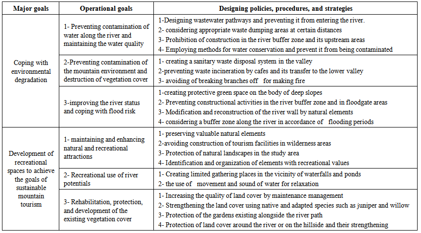 | Table 3. Physical planning for development of the site |
Strategic map of the site The land uses were allocated in the site considering available facilities and existing constraints. The output is depicted in Fig.5 as the strategic map of the site. Moreover, some strategies were recommended for development of the site. Generally, most of the proposed land uses are categorized as extensive recreation, which involves limited development activities. This would impose minimal, destructive impact on the nature.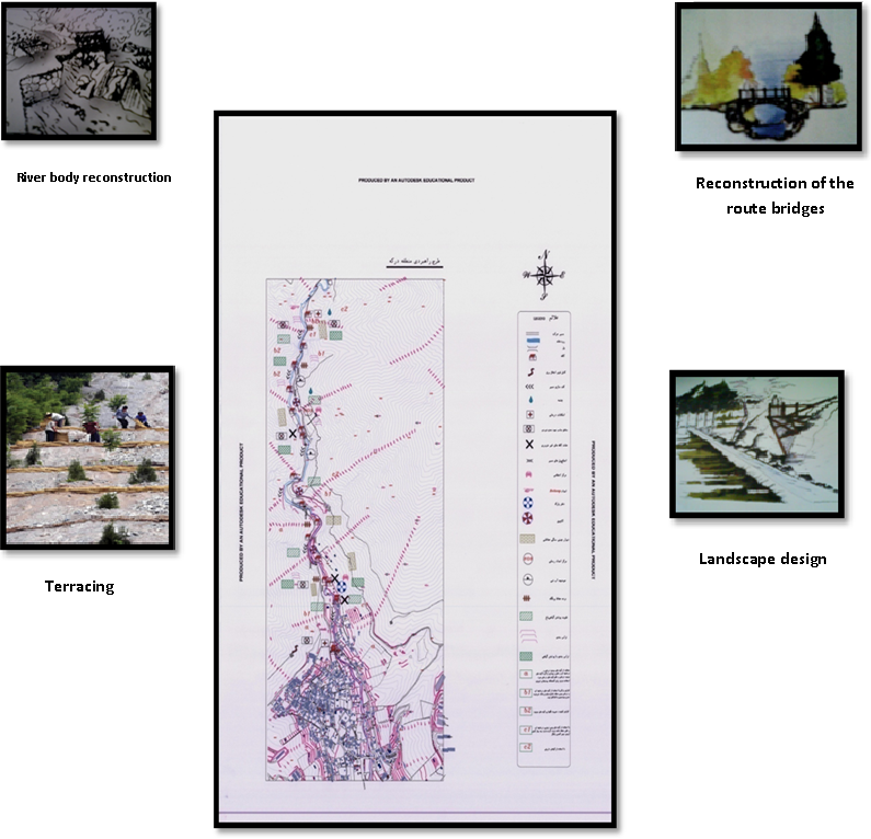 | Figure 5. Strategic planning of the site |
Designed master plan In this research, a site located in Zone 2 in the vicinity of the Darakeh River was designed for intensive recreation. Avoiding decentralization of activities in one place greatly reduces the destruction of the environment and nature. Physical planning of recreational areas Considering that Darake is situated in District 1, it will be visited by the citizens from the western and northwestern Tehran. Accordingly, areas located adjacent to the seasonal river were dedicated to recreational resorts and camping sites. Physical planning is essential for providing tourists' comfort. Considering carrying capacity of the park for ecotourism development, required area for establishment of different land uses was estimated. Recreational area: Recreational sites were supposed to be established adjacent to natural rocks as well as upstream areas of Darakeh River. Appropriate land uses selected for the site include camping sites, a buffet, restrooms, access routes among land uses, a pavilion to provide horticultural products, and bridges.Physical planning procedure Physical planning of the nature park was done according to the following principles: Road improvement: improvement of roadside slopes, identification of areas vulnerable to erosion, and stabilization of erosion-prone areas using appropriate methodsCamping Design: In this research, design of camping wad done considering the following considerations: - Number of people visiting the site,- Situation of the site and its distance from Tehran City,- restrooms, and a buffet (to supply essential food items)- Special places for cooking stoves, barbeques, and field dishwashers- easy access to potable water and waste dumping areas- Appropriate visual landscape at site and its surroundings, - Proper selection of plants, especially native species compatible with the environment to prevent erosion at upstream of picnic areas, as a green belt providing either beautiful scenery or good shade on hot, sunny day sCompetence with riparian: considering the changing riparian buffer zone for the seasonal rivers, a low-user access was positioned at places with suitable land cover.Accessibility to recreational sites: this criterion involves easy and convenient access to land uses and campsWatercourses and river: it refers to maximum use of river aesthetics along with considering a riparian buffer zone in an appropriate extent Rock climbing route: it is required to provide security to rock climbers and to restore them as natural habitats for animals and birds Management and surveillance: the conceptual master plan of Dareh-Darakeh is depicted in Figure 6.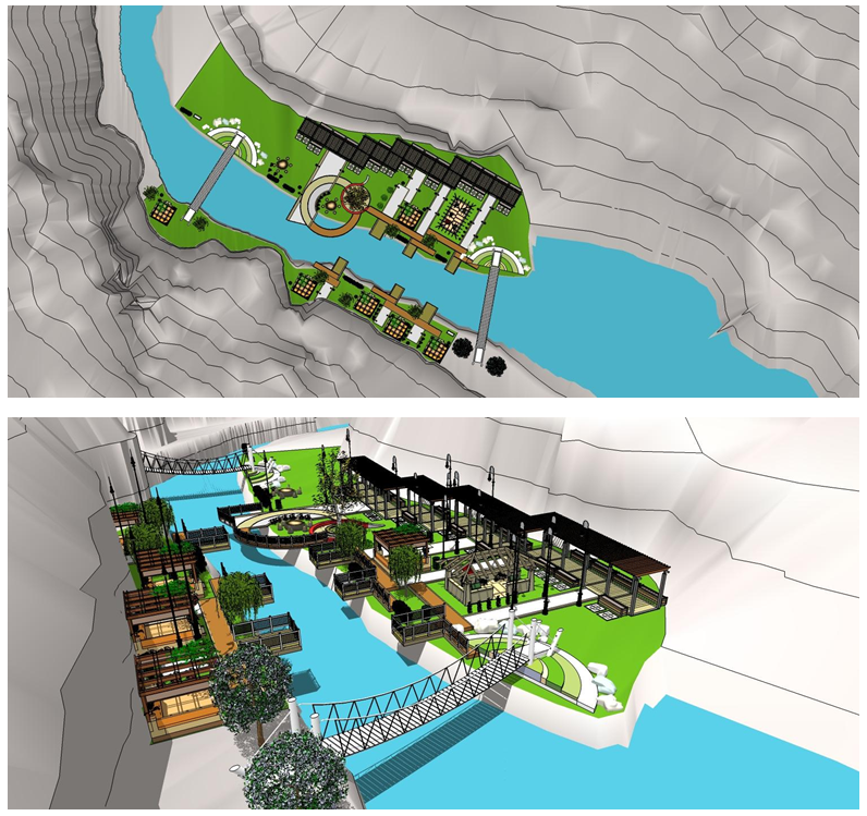 | Figure 6. Conceptual master plan designed for Darake region |
4. Conclusions
Southern slope of Alborz Mountain is one of the valuable natural heritage areas in Tehran. It is a traditional promenade for Tehran citizens and prevents sprawl of the city towards north direction. In this research, Dareh-Darakeh Nature Park was designed for ecotourism development in Tehran City. For this, compatible land uses were selected considering the existing possibilities and opportunities. Afterwards, the land uses were allocated in the site in a way to meet the principles of sustainable development. River-valleys upstream of Tehran have a determining role in ecotourism development in the city. Sustainable design of corridors and patches in the site provides the possibility of sustainable development of mountain tourism and tour activities in the river- valleys of Tehran.
ACKNOWLEDGEMENTS
We hereby appreciate proof-reading services rendered by Ravian Danesh Mohit Company.
References
| [1] | Lane, M., 2010, the carrying capacity imperative: Assessing regional carrying capacity methodologies for sustainable land-use planning, Land Use Policy, 27 (4), 1038–1045. |
| [2] | Prato, T., 2009, Fuzzy adaptive management of social and ecological carrying capacities for protected areas, Journal of Environmental Management, 90(8), 2551–2557. |
| [3] | Navarro Jurado, E., Tejada Tejada, M., Almeida García, F., Cabello González, J., Cortés Macías , R., Delgado Peñad, J., Fernández Gutiérrez, F., Gutiérrez Fernández, G., Luque Gallego, M., Málvarez García, G., Marcenaro Gutiérrez, O., Navas Concha, F., Ruiz de la Rúa, F., Ruiz Sinoga, J., and Solís Becerra, F.,2012, Carrying capacity assessment for tourist destinations. Methodology for the creation of synthetic indicators applied in a coastal area. Tourism Management, 33(6), 1337–1346. |
| [4] | Saveriades, A., 2000, Establishing the social tourism carrying capacity for the tourist resorts of the east coast of the Republic of Cyprus, Tourism Management, 21 (2), 147-156. |
| [5] | Saarinen, J., 2006, Traditions of sustainability in tourism studies, Annals of Tourism Research, 33(4), 1121-1140. |
| [6] | Yong Ahn, B., Koo Lee, B., and Scott Shafer, C., 2002, Operationalizing sustainability in regional tourism planning: an application of the limits of acceptable change framework, Tourism Management, 23(1), 1-15. |
| [7] | Kim, K., Uysal, M., and Joseph Sirgy, M., 2012, How does tourism in a community impact the quality of life of community residents?, Tourism Management, 36, 527–540. |
| [8] | Castellani,V., and Sala, S.,2010, Sustainable performance index for tourism policy development, Tourism Management, 31(6), 871-880. |
| [9] | M. Forman, and M. Goron, “Landscape Ecology”, John Wiley & Sons, UK, 1986. |
| [10] | Deniz, B., Kılıçaslan, Ç., Kara, B., Hilal Göktug, T., and Kutsal, E., 2011, Evaluation of the tourism potential of Besparmak Mountains in the respect of protection – use balance, Procedia - Social and Behavioral Sciences,19, 250-257. |
| [11] | Glück, P., 2002, Property rights and multipurpose mountain forest management, Forest Policy and Economics, 4(2), 125-134. |
| [12] | earth summit, united nation conference on enviroment, rio de janeiro, Argentina, 1992. |
| [13] | Laghaei, H., 1994. Construction of mountain parks in Tehran; a necessary action to protect and improve the environment, Fazaye Sabz Journal, 9 and 10, [in Persian]. |
| [14] | Paseban Hazrat, Gh., “Design in nature”, Ganj-e Honar Publication, Tehran, Iran, 2004 [in Persian]. |
| [15] | Makhdoum, M., “foundation for landuse planning”, edit 2, institute of publishing and printing, Tehran, Iran, 2002. |
| [16] | Consulting engineers tarh & taavon, consulting service in urban planning. check the darake area, tehran, Iran, 2008. |
 Abstract
 Reference
 Full-Text PDF
 Full-text HTML