-
Paper Information
- Previous Paper
- Paper Submission
-
Journal Information
- About This Journal
- Editorial Board
- Current Issue
- Archive
- Author Guidelines
- Contact Us
International Journal of Ecosystem
p-ISSN: 2165-8889 e-ISSN: 2165-8919
2014; 4(3): 107-118
doi:10.5923/j.ije.20140403.02
Development of Mangrove Conservation Area Based on Land Suitability and Environmental Carrying Capacity (Case Study from Probolinggo Coastal Area, East Java, Indonesia)
 Abstract
 Reference
 Full-Text PDF
 Full-text HTML
Bambang Suprakto 1, Soemarno 2, Marsoedi 3, Diana Arfiati 3
1Doctoral Program of Agricultural Sciences, Faculty of Agriculture, University of Brawijaya, Malang, Indonesia
2Faculty of Agriculture, University of Brawijaya, Malang, Indonesia
3Faculty of Fisheries and Marine Sciences, University of Brawijaya, Malang, Indonesia
Correspondence to: Bambang Suprakto , Doctoral Program of Agricultural Sciences, Faculty of Agriculture, University of Brawijaya, Malang, Indonesia.
| Email: |  |
Copyright © 2014 Scientific & Academic Publishing. All Rights Reserved.
Regions with coastal areas and qualify for mangrove growth must preserve and develop mangrove forests as protected areas. Probolinggo District has a coastal length of 72 km and 714.2 ha of mangrove forest area. The objective of this research is to determine land suitability and environmental carrying capacity mangrove conservation area. Analysis of mangrove forests condition is based on Important Value Index (IVI), carrying capacity, land suitability, and supporting software of ArcView 3.2 and ArcGIS version 8.1. The condition of mangrove forests on level of high to very high of density belongs to Rhizophora mucronata, while low-moderate level of density belongs to R. mucronata and Sonneratia alba. The reforested mangrove belongs to R. mucronata and R. stylosa. The water quality (temperature, salinity and pH) is eligible for mangrove growth. The soil pH is neutral, total N elements is 0.03-10%, P-Olsen is 6.56-9.72 mg kg-1 and K is 1.83-2.35 me 100gr-1. Overall, the soil texture is sandy clay loam, except for the east area of Paiton Sub-district which is rocky sand. The tide type is diurnal with daily pattern towards the mangrove areas (10-25 days month-1). The current velocity is slow (<1 m sec-1). At certain seasons, periodically, the wave height reaches > 2 m. 31174.18 ha of coastal land area consists of land class S1 = 734.06 ha; class S2 = 877.35 ha, and class S3 = 29562.77 ha. Each parameter has an influence on the availability of land suitability class. S1 and S2 are lands which have the potential for development of mangrove conservation area. The vast of the land area has not met the need for environmental carrying capacity of mangrove area of 2433.6 ha or approximately 822.19 ha. The existing mangrove forests should be preserved and gradually rehabilitated with Rhizophora sp. to accelerate the development of mangrove conservation area.
Keywords: Mangrove conservation, Land suitability, Environmental capacity, Probolinggo district coastal area
Cite this paper: Bambang Suprakto , Soemarno , Marsoedi , Diana Arfiati , Development of Mangrove Conservation Area Based on Land Suitability and Environmental Carrying Capacity (Case Study from Probolinggo Coastal Area, East Java, Indonesia), International Journal of Ecosystem, Vol. 4 No. 3, 2014, pp. 107-118. doi: 10.5923/j.ije.20140403.02.
Article Outline
1. Introduction
- Mangrove forests are an important ecosystem in coastal area due to their very complex ecological, physical, or socio-economic function [1-5]. As a result of rapid activities and population growth in coastal areas, mangrove forests in Indonesia have been converted into industrial zones, ports, housing and ponds. The destruction of mangrove forests is also caused by intensive use for firewood, building materials, and animal feed [2, 3, 6-9]. Coastal mangrove of Java Island has lost 70% of its area since 1985. Mangrove forest area in 1970 reached 8.6 million ha; it remained only 5.2 million ha in 1982 and 3.7 million ha in 1992 [2, 10]. Based on scientific studies, the availability of coastal areas that eligible for the growth of mangroves is 130x the average range of the highest and the lowest tide, or a minimum 200 m width along the beach and 50 m along the river banks. However, most coastal areas in Indonesia, especially in North Java and Madura strait, the existence of mangrove forests have not been eligible. It is become necessary to prevent the damage and restore the mangrove forests to improve the economy of coastal communities that rely on mangrove ecosystems [1, 11]. An effort to improve and develop mangrove forest is the establishment of mangrove forest conservation area [12]. As a concrete act, it requires planting activities to accelerate mangrove forests extension. The result of mangrove planting activities, as one of the framework in the development of conservation area, often fails due to a high mortality rate [5]. This is due to deficient information and data on land suitability and environmental carrying capacity of coastal for the growth of mangrove. Therefore, the general objective of this research is to determine the land suitability and environmental carrying capacity of mangrove conservation area. In particular, the purpose of this study is to determine: (1) the condition of mangrove forests, (2) the carrying capacity of coastal marine environment, (3) land suitability class for mangrove forests, and (4) development pattern of mangrove forest conservation area.
2. Materials and Methods
- This research was conducted in the coastal of Probolinggo District, East Java, Indonesia in geographical position between 112° 50 ' to 113° 30 'E longitude and 7° 40' to 8° 10' S latitude. The study conducted in January to May 2013.
2.1. Data Collection
- The study used purposive sampling method. Mangrove forest conditions, water quality, soil quality, coastal bathymetry and current velocity were determined at nine (9) stations. The tidal was sampled at one station. The primary data are mangrove forest conditions, which obtained from on-site measurements and observation of water quality (temperature, salinity and pH). The soil sampling used a 2-inch PVC pipe with a length of 50 cm. The sample was taken from 30 cm depth, and analyzed in the laboratory. The tidal, current velocity and bathymetry were also determined on site. The coastal type and land coverage data were conducted with ground checks. While the secondary data were documents from Department of Forestry and Plantation, Department of Marine and Fisheries, and Central Statistic of Probolinggo District [13], Center for Management of Marine and Coastal Resources (for Land Resource map), Coordinating Agency for Survey and Mapping (RBI map), Bandung Geological Research and Development Centre (Geological map) and Google Earth imagery (2013).
2.2. Data Analysis
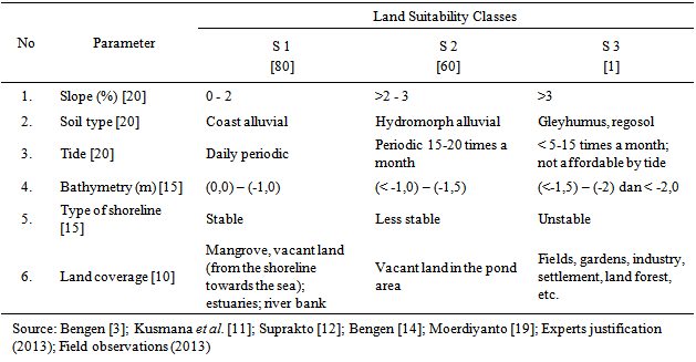
- Quantitative-descriptive method was used for data analysis. The quantitative analysis was based on numerical data. Data analysis was used to determine the concept of mangrove conservation development. 1. Analysis of mangrove forests condition is based on Important Value Index [14, 15, 16]: Ni = RDi + RFi + RCiDescription: Ni = Important Value Index of Species (i) RDi = Relative Density Value of Species RFi = Relative Frequency Value of Species RCi = Coverage Value of Species 2. Carrying capacity of the coastal environment: - Analysis of water quality (temperature, salinity, and water pH) [17] - Analysis of soil quality (soil pH, N-total, P-Olsen and K) - Analysis of tide range and type using formhazl numbers of Pugh (1987) - Analysis of current velocity using Kreyzig (Rashid, 2000) 3. Analysis of land suitability for mangrove conservation area according to Suprakto [12] and expert’s justifications. Parameters, qualities and classes of land suitability for mangrove conservation areas were showed in Table 1. The classification were based on the potential for mangrove conservation area that divided into three (3) classes: ● Highly suitable class (S1): a very good suitability with very minor limiting factors.● Suitable class (S2): a good suitability with certain limiting factors, but it still can be developed for mangrove conservation area.● Not suitable class (S3): less and inappropriate because it has permanent and very heavy limiting factors. The Supporting software used in the analysis are ArcView 3.2 and ArcGIS version 8.1 [12, 18].
|
3. Results and Discussion
3.1. Analysis of Mangrove Forest Conditions
- Mangrove forests condition are classified into three (3) mangrove forest: 1) Mangrove forest with high – very high level of vegetation density2) Mangrove forest with low – moderate density 3) Reforested mangrove forests
3.1.1. High – Very High Level of Vegetation Density
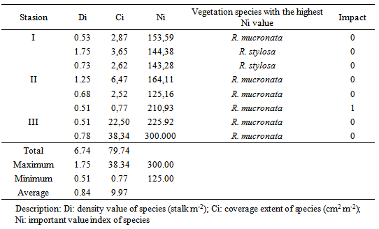
- The averages density value of species (Di) is 0.84 stalk m-2, the maximum density value is 1.75 stalk m-2 and the minimum density value is 0.51 stalk m-2 (Table 2). The condition of mangrove vegetation is classified as a high level of density which ranges from 0.51 to 1.00 stalk m-2 [14, 20]. The coverage value of species (Ci) to the average land area is 9.97 cm2 m-2 or classified into a high coverage category [20]. The maximum coverage value is 38.34 cm2 m-2 and the minimum coverage is 0.77 cm2 m-2. The important value of species (Ni) ranges from 125.16 to 300.00. Mangrove vegetations with the highest important value index are found only Rizophora mucronata (300.00) and R. stylosa (144.38). The important value index of species became a consideration in determining the suitable species of mangrove to be cultivated in an area [14]. For that, the development of mangrove forests with a high - very high level of density can use R. mucronata as the first alternative, and R. stylosa as the second alternative [12, 21, 22].
|
3.1.2. Low – Moderate Level of Vegetation Density
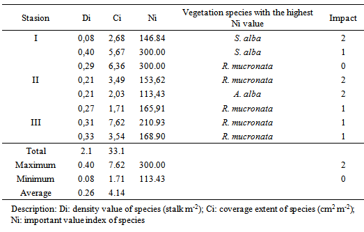
- The averages density of species (Di) is 0.26 stalk m-2 or at the level of moderate density (Table 3). The maximum density value of species is 0.40 stalk m-2 and the minimum is 0.08 stalk m-2 or at low - moderate level of density [14,20]. The coverage value of species (Ci) averages 4.14 cm2 m-2, with the maximum coverage value of 7.62 cm2 m-2 and the minimum coverage of 1.71 cm2 m-2. The coverage of species is moderately suitable [19]. The highest important value index of species (Ni) belongs to R. mucronata (300) and S. alba (300) and the lowest is A. alba (113.43). The species specification of vegetation for the development of mangrove areas at low - moderate level of density respectively are R. mucronata as the first alternative and S. alba as the second alternative [12, 21, 22].
|
3.1.3. Reforested Mangrove Forests
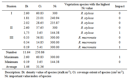
- The averages density value of species (Di) is 1.46 stalk m-2 with the maximum density value 2.60 stalk m-2, and the minimum density value 0.19 stalk m-2 (Table 4). The density value of species is classified as high density [13, 19]. The coverage value of species (Ci) to the area averages 31.36 cm2 m-2, the maximum coverage value is 60.83 cm2 m-2 and the minimum coverage is 3.65 cm2 m-2. The vegetation coverage value to the area is categorized high [20]. The highest important value index of species belongs to R. mucronata and R. stylosa, both have the same Ni, 300.00. This is consistent with the overall results of reforestation using seedlings of R. mucronata and R. stylosa. While the other species such as Avicennia sp. grows naturally among the dominant mangrove vegetation [12, 21, 22]). The reforested mangrove was generally not affected (0) and only lightly affected on the plot 2.2 and 3.3 due to human activities.
|
3.2. Analysis of Environmental Carrying Capacity
3.2.1. Water and Soil Quality
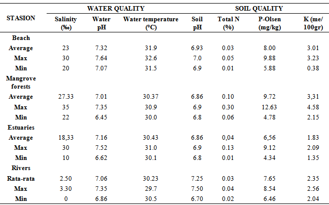
- The analysis of water and soil quality on beach, mangrove forests, estuaries, and rivers on coastal areas showed in appendix 1. The average salinity was 2.50-27.33 ‰ with the maximum and minimum values are respectively 35 ‰ and 0 ‰. Salinity of 0 ‰ was found in rivers and salinity 35 ‰ was found in mangrove forests. The average water pH is 7.01 - 7.32 with the maximum and minimum values are 7.64 and 6.62 respectively. The average water temperature ranges between 30.23-30.90℃ with the maximum and minimum water temperature 32.6℃ and 29.7℃. The quality is at the limit of the tolerance range for the growth of all species of major mangroves (Rhizophora sp., Bruguera sp., Sonneratia sp. and Avicennia sp.) [1, 3, 11]. The average soil pH ranges from 6.86-7.25, with the maximum and minimum values 6.7 and 7.5, respectively. Average of total Nitrogen (N) was 0.03 to 0.10% with the maximum and minimum values 0.01% and 0.30%, respectively. Phosphate (P)-Olsen averages 6.56-9.72 mg kg-1 with the maximum and minimum values are respectively 12.63 mg kg-1 and 4.34 mg kg-1. Potassium (K) averages between 1.83- 2.35 me 100gr-1 with the maximum and minimum values 4.58 me 100gr-1 and 0.38 me 100g-1, respectively. For mangrove growth, total N and P-Olsen are in a sufficient category and K is in high category [23-26]. Coastal areas without mangroves at a distance of > 1000 m to estuaries are dominated by sandy soil texture or less suitable for mangrove vegetation [12]. Regions at a distance > 500 - 1000 meters to estuaries have a sandy clay loam soil texture or suitable for Rhizophora sp. and Avicennnia sp. [11]. The soil texture in mangrove forests with a high-very high level is mostly sandy clay loam. Otherwise, soil texture in mangrove forests with low-moderate level of density is mostly sandy clay loam and muddy sand. Estuaries’soil texture is mostly muddy soil and sandy clay silt. While in the East coast of Paiton sub-district is partly rocky. These muddy, sandy clay loam or sand soil texture is mangrove habitat. Even some mangrove vegetations are often found on rocky substrates [11, 14]. However, the main mangrove vegetations, Rhizophora sp., Bruguera sp., Sonneratia sp., and Avicennia sp., grow very well on soil with muddy substrate and sandy clay loam texture [11, 13, 27, 28].
3.2.2. Hydro Oceanography
- Analysis of tidal measurements for 15 days (January 9th – 23rd 2013) in the coast of Probolinggo indicates that the tide types are semi-diurnal and diurnal incline to semi-diurnal. The range of the highest and the lowest tide reach 2.70 m. At high tide, the average height range reaches 1.18 m. The tidal current movement comes from the East to the West. The condition is different from Madura strait waters around Surabaya. The range of the highest tide reaches 3 m [29]. This is because the Madura strait near the Surabaya is narrower than the strait in the region of Probolinggo District. The current near the coast of Probolinggo is 0-0.17 m sec-1 with an arbitrary direction. At high tide, the current flows westward with the maximum velocity reaches 0.17 m sec-1 and at low tide, the maximum velocity reaches 0.11 m sec-1. The current strength is relatively weak when compared with the current occurs near the coast of Surabaya which reaches 1.7 m sec-1 [29]. The current condition in the coastal waters of Probolinggo is strongly influenced by ocean current which occurs in Java Sea [30]. According to Department of Region Development and Planning of Probolinggo [31], 5-year return period of maximum wave height from the Northwest reaches 2.8 m; 2.13 m from the North; and 3.69 m from the Northeast. While the 10-year return period of maximum wave height from the Northwest reaches 2.96 m, 2.30 from the North, and 3.90 m from the Northeast. The maximum wave height only occurs in a certain time period (January-March) in one year. The wave height is very influential on the level of life and growth of mangroves because mangroves grow well in areas that sheltered from high waves [3, 14, 27, 30, 32].
3.2.3. Land Suitability for Mangrove Conservation Area
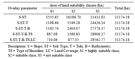
- Coastal boundaries (Law No. 27/2007) are the district’s administrative boundaries which have a coast to the closest districts to the inland. Overlay process on several parameters in the coast of Probolinggo is obtained a land extent for mangrove conservation areas (Table 5).
|
3.3. Development of Mangrove Conservation Area
3.3.1. Establishing the Conservation Area
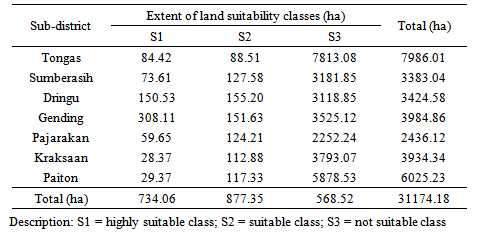
- Based on the land suitability classification, highly suitable class (S1) and suitable class (S2) are the classes which have the potential to be developed into a mangrove conservation area. The number of potential land area is 1611.41 ha. S1 is 734.06 ha (including some of the mangrove forest) and S2 is 877.35 ha. Establishment of Mangrove conservation area in Probolinggo refers to the results of the analysis of land suitability classes in each sub-district. The seven sub-districts in coastal areas, Gending sub-district has the widest class S1=308.11 ha and S2=151.63 ha then followed by Dringu sub-district, Sumberasih sub-district, Tongas sub-district, Pajarakan sub-district, Paiton sub-district and Kraksaan sub-district (Table 6). The map of conservation area land suitability in the coastal area of sub-districts, Probolinggo district can be viewed in Appendix 3.
|
3.3.2. Development and Preservation of Mangrove Forests
- Mangrove forests of Probolinggo cover an area of 714.2 ha; 598.8 ha are in good condition and 115.4 ha are in damaged condition (Department of Plantation and Forestry, Probolinggo District, 2012). The mangrove forests should be maintained and the damaged ones need rehabilitation. The damage impact to the mangrove forests with minor and moderate level are mostly caused by human activities. It is required community participation to preserve the mangrove forests as a key component of mangrove forest conservation pioneers [3, 9, 12, 32, 33]. In accordance with the important value of species, the mangrove vegetations suitable for rehabilitation are R. mucronata and R. sylosa. Both of these mangrove species have root systems that can support the coastal protection and relatively grow faster, as well as a higher level of life [27, 34]. Mangrove forests area can occur naturally and by planting activities. Planting mangrove is an attempt to accelerate the development of the area by prioritizing land eligible for the rehabilitation [11, 27]. Land extent of S1 (734.06 ha) is consisted of mangrove forests and only ± 19.86 ha is not. While S2 (877.35 ha) is largely vacant land from the sea towards the shoreline (around mangrove forests), shrubs, pond area and rivers [11, 12]. Suitable mangrove vegetation to plant on S1 can refer to the highest important value index of species (150-300) in the nearby mangrove forests. The planting could be done with propagules (fruit) or nursery seedlings. While mangrove for S2 we reommend nursery seedlings of Rhizophora sp., because the areas get periodically wave effect [11, 14]. The relatively protected areas or the area that periodically affected by wave were planting by the nursery seedlings. It reaches 80% level of life, while the direct planting with propagules reaches only 40%. Rhizophora sp. has a higher level of life in a relatively open area [14, 27]. In open areas with the wave height periodically reaches > 2 m, the planting is done by using the nursery seedlings, a closer spacing and with an alternating pattern. The mangrove seedlings are tied to the stake and are equipped with a wave barrier [11]. The sea current is relatively slow which less than 1 m sec-1 is. The condition is very good for the growth of mangroves because it does not disturb root structure and very helpful in transporting nutrients needed by mangrove vegetations [3, 11, 22].
4. Conclusions
- 1. There are three (3) categories of mangrove forests in the study area. They are high - very high density, low- moderate density, and reforested mangrove; with the highest important value index are R. mucronata, R. stylosa and S. alba. 2. The water quality and soil quality are eligible for mangrove vegetations growth with most of the soil textures are sandy clay loam. The tide pattern is diurnal daily inundation with slow near shore current. At a certain season, the wave height reaches > 2 m. 3. The extent of land suitability for mangrove conservation area classes S1 = 734.06 ha; S2 = 877.35 ha, and S3 = 29562.77 ha, spreads over seven coastal sub-districts. 4. The development of mangrove forests is prioritized on land class S1 around the mangrove forest and restores the damaged mangrove forests. Area with periodically affected waves, the mangrove planting used nursery seedlings which was equipped with a stake or retention waves and implemented in stages.
5. Suggestion
- Further researches on: 1. The influence of oceanographic process and soil texture on the life level of mangrove Rhizophora sp.; 2. mangrove vegetation for various types of shoreline; and 3. community participation in conserving mangrove forests; are needed for mangrove forest conservation areas preservation and development.
Appendix 1. Analysis of Water and Soil Quality
Appendix 2. Land Suitability Map of Mangrove Conservation Areas in Probolinggo District Coastal Area, East Java, Indonesia
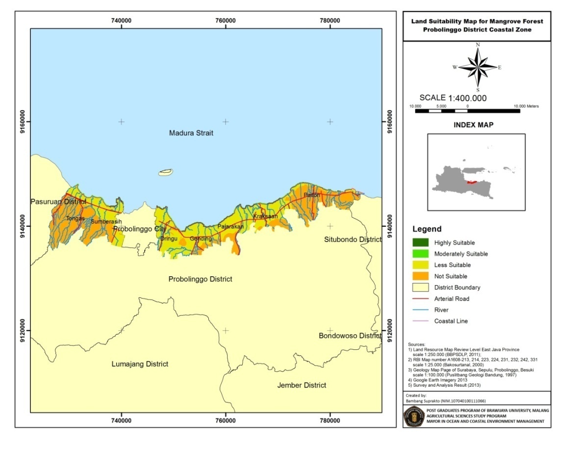 | Figure 1. Land suitability map of mangrove conservation areas in Probolinggo district |
Appendix 3. Land Suitability Map of Mangrove Conservation Areas in Sub-districts, Probolinggo District Coastal Area
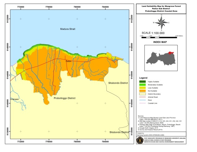 | Figure 2. Land suitability map of mangrove conservation areas in Paiton sub-districts |
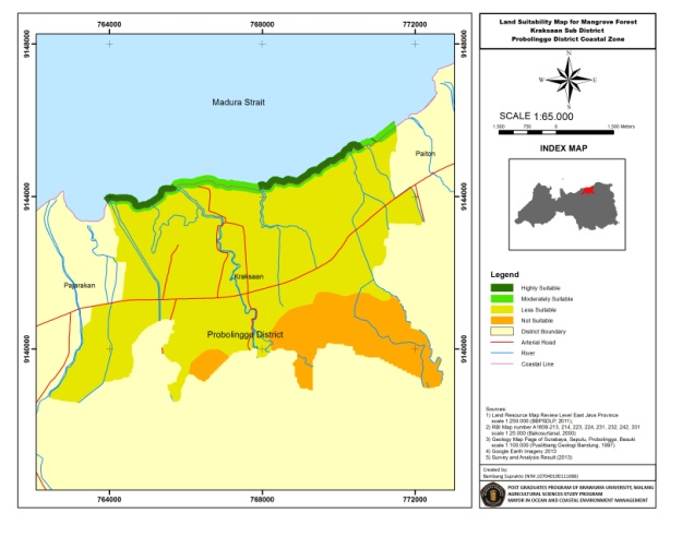 | Figure 3. Land suitability map of mangrove conservation areas in Kraksaan sub-districts |
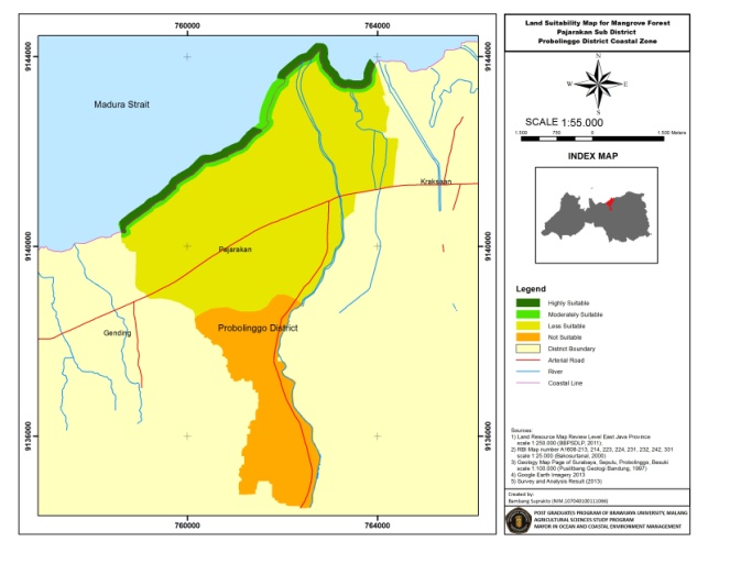 | Figure 4. Land suitability map of mangrove conservation areas in Pajarakan sub-districts |
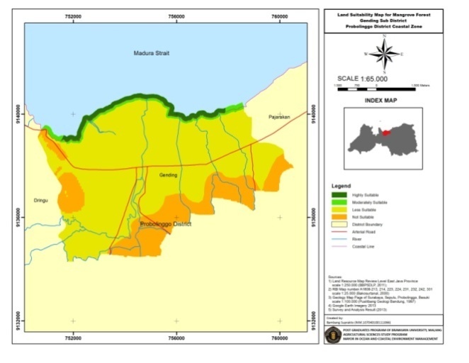 | Figure 5. Land suitability map of mangrove conservation areas in Gending sub-districts |
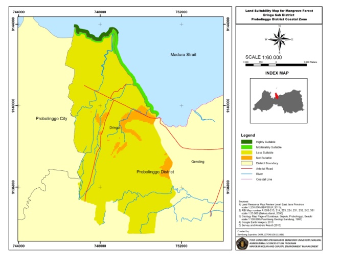 | Figure 6. Land suitability map of mangrove conservation areas in Dringu sub-districts |
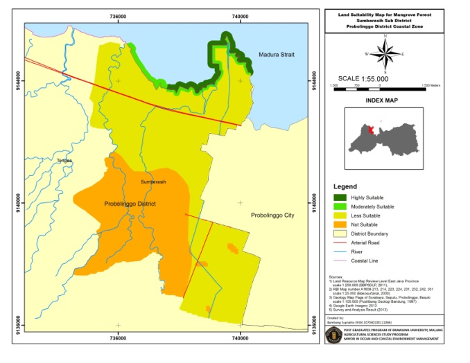 | Figure 7. Land suitability map of mangrove conservation areas in Sumberasih sub-districts |
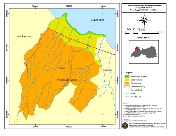 | Figure 8. Land suitability map of mangrove conservation areas in Tongas sub-districts |