Haryuni1, Marsoedi2, Nuddin Harahab2, Daduk Setyohadi2
1Doctoral Program of Agricultural Sciences, Faculty of Agriculture, University of Brawijaya, Malang, Indonesia
2Faculty of Fisheries and Marine Sciences, University of Brawijaya, Malang, Indonesia
Correspondence to: Haryuni, Doctoral Program of Agricultural Sciences, Faculty of Agriculture, University of Brawijaya, Malang, Indonesia.
| Email: |  |
Copyright © 2014 Scientific & Academic Publishing. All Rights Reserved.
Abstract
The aim of this study was 1) to assess the mangrove vegetation condition from mangrove distribution and composition and Importance value index (IVI), and 2) to assess the water quality from physico-chemical parameters and primary productivity in the coastal waters of Seruyan Regency. The study was carried out from December 2012 to May 2013, on 3 mangrove zones or habitats in the coastal area of Seruyan Regency, Central Kalimantan, i.e. Zone I (Sungai Bakau Village), Zone II (Kuala Pembuang II Village); and Zone III (Sungai Gintung Village). Data were obtained by Line Tansect Plot method, population sampling of an ecosystem with sample plot approach along the line put from the coastal line toward the land. Vegetation diversity showed that mangrove distribution in the study site was structured by 5 species, Avicennia marina, Excoecaria agallocha L, Nypa fruticans, Rhizophora apiculata, and Sonneratia caseolaris. Zone I (Sungai Bakau village) had 16 individuals (69.6%) of N. fruticans and 7 individuals (30.4%) of S. caseolaris, with a density of 6 ind/100 m2. Zone II (Kuala Pembuang II village) had 66 individuals (89.2%) of A. marina,4 individuals (5.4%)of E. agallocha and 4 individuals (5.4%) of R. apiculata, with a density of 15 ind/100 m2. Zone III (Sungai Gintung village) had only A. marina as many as 30 individuals (100 %). The mangrove density was 10 ind/100 m2. Moreover, the importance value index in zone I was 151.4 for N. fruticans and 148.6 for S. caseolaris. In zone II, the highest IVI occurred in A. marina (231.7), followed by E. agallocha (50.0) and Rhizophora apiculata (18.3). In zone III, since A. marina was the only spesies found, the IVI was 300.0. Mangrove productivity was 100 gr C/m2/yr in zone I, 63.98 gr C/m2/yr in zone II, and 35.36 gr C/m2/yr in zone III, respectively. Physico-chemical parameters, such as temperature, pH, DO, and total suspended solid still met the provision of Minister’s Decree for Living Environment No. 51, 2004. Except that nitrate (N-NO3) and phosphate (P-PO4) exceeded provision of seawater quality standard, 0.008 mg/l for nitrate (N-NO3) and 0.015 mg/l for phosphate (P-PO4).
Keywords:
Composition, Distribution, IVI, Mangrove Vegetation, Seruyan Regency, Water Quality
Cite this paper: Haryuni, Marsoedi, Nuddin Harahab, Daduk Setyohadi, Mangrove Vegetation and Water Quality Conditions in the Coastal Area of Seruyan Regency, Central Kalimantan, International Journal of Ecosystem, Vol. 4 No. 2, 2014, pp. 89-94. doi: 10.5923/j.ije.20140402.07.
1. Introduction
Central Kalimantan has a coastal line approximately of 750 km long and 16,361 km2 areal widths administratively cover seven regencies: Kapuas, Pulang Pisau, Kotawaringin Timur, Katingan, Seruyan, Kotawaringin Barat and Sukamara [1]. Seruyan is the regency developed from Kotawaringin Timur regency since 2002. Seruyan regency possesses about 100 km long of coastal line, where exists as a conservation forest area, based on RTRWP of Central Kalimantan, i.e. Regencial Regulation No. 08, 2003, consists of National Park of Tanjung Puting (TNTP) of 162,968.08 Ha (93%) and mangrove forest of 8,020.00 Ha (0.49 %) [2]. Mangrove is one of habitats found in the estuary and shallow coastal waters, and in tropics, mangrove forest is mostly a dominant habitat type in the estuarine area [3]. As typical ecosystem in the coastal area, mangrove forest has several important ecological roles, a) as wave muffler, beach protector from abrasion, mud holder and sediment trap; b) detritus producer; and c) nursery ground, feeding ground and spawning ground for aquatic organisms living in coastal waters or open oceans [4].Coastal ecosystems of Central Kalimantan at least possess 8 big rivers dominated by estuarine and mangrove ecosystems with high sedimentation rate. Besides that, sedimentation has been aggravated by various environmental unfriendly human activities in the terrestrial area; for instance, illegal logging, illegal mining, mangrove forest conversion to fish pond area, land use violating the regulation or inappropriate to spatial plan, gives also negative impacts to the coastal environment. Seruyan regency, since developed to be a new regency, the mangrove forest conversion to fish pond area in the last 10 years has been extensive enough, in which fisheries statistics issued by Marine and Fisheries Services of Seruyan Regency indicates that the fish pond area has reached 1310 Ha [5]. Extensive mangrove forest conversion to ponds, aquaculture was an underestimated problem [6]. No mangrove forest management in this area also makes monitoring activities and specific environmental studies neccesary to carry out. This study was conducted to ensure that the mangrove ecosystem could be well taken care so that people could continuously gain ecological and economic benefits and values for the indigenous people from the presence of mangrove forests [7,8].Based upon the background and problems mentioned above, the objectives of the study were as follows:1. To assess the condition of mangrove vegetation from distribution and composition of mangrove species (density, frequency, and dominance/coverage) so that the importance value index was obtained and used to know the extent of roles of each mangrove on the entire mangrove ecosystem in the coastal area of Seruyan regency.2. To assess the water quality from physico-chemical parameters and primary productivity in relation with mangrove vegetation condition in Seruyan regency.
2. Materials and Methods
This study was conducted in December 2012 to May 2013, in three mangrove zones or habitats in the coastal area of Seruyan regency, Central Kalimantan, i.e. Sungai Bakau village, Kuala Pembuang II village and Sungai Gintung village (Fig. 1).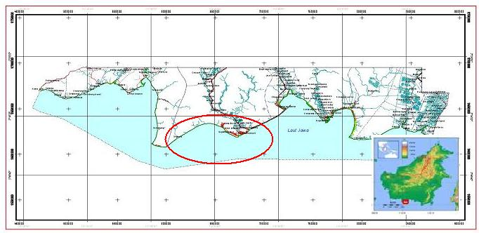 | Figure 1. Study Site |
2.1. Data Collection
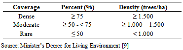
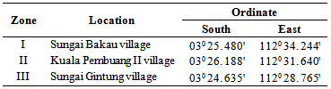
Variables observed in this study to gain the mangrove vegetation profile were: a. Mangrove species name.b. Number of mangrove trees by spesies.c. Stem diameter, by stem circle measurement (cm).d. Measurement of leaf litter weight (g).e. Measurement of physico-chemical parameters around the mangrove vegetation. Before data sampling, field surveys were done in order to get general description of mangrove vegetation density, plant size higher than 1m and stem diameter ≥10 cm at each study site, using field transect method, based on the criteria of State Minister’s Decree for Living Environment No. 201, 2004 (Table 1). Sampling site was selected using purposive sampling for mangrove vegetation density, and then observation points were divided into three sampling zones /stations (Table 2). Mangrove vegetation observation in this zone was made in three, four, and five sample plots, each of which was 10 m x 10 m, so that total plot cover was 300 m2, 400 m2 and 500 m2, respectively.Table 1. Standard criteria for mangrove density
 |
| |
|
Table 2. Observation zones and ordinate points of the study sites
 |
| |
|
Measurements for mangrove vegetation condition used Line Transect Plot Method and Sample Plot, population subsampling of an ecosystem with sample plot approach along the line passing the ecosystem. There were several phases in data sampling with Line Transect Plot:a) In each observation station/zone line transects were put from the coastal waters toward the land (rectangle to the coastal line along the mangrove forest zonation in the intertidal).b) In each mangrove zone along the transect line, the rectangular sample plots were randomly placed at least three samples plot. General description of the sample plot can be seen [10] in Figure 2. A 10x10 m transect was used to count number of > 10 cm diameter trees. A 5 x 5 m transect was utilized to count number of 2-10 cm saplings. A 1 x 1 m transect was used to count number of seedlings, diameter < 2 cm. c) Each sample plot was determined mangrove species, counted the number of individuals by species, and measured the stem circle for approximately 1.3 m high trees (Diameter at Breast Height; DBH).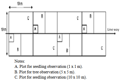 | Figure 2. Sample plots along the Line Transect Plot |
2.2. Analytical Method of Mangrove Vegetation and Water Quality
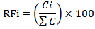
Mangrove vegetation analysis (density, frequency and dominance/coverage) was intended to obtain the importance value index usable to know the extent of role of each mangrove species in the entire ecosystem. Number of species relative density values (RDi), species relative frequency (RFi) and species relative covers (RCi) [4]. Data analyses of mangrove vegetation were as follows:
2.2.1. Species Relative Density (RDi)
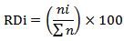 Description:
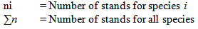
2.2.2. Species Relative Frequency (RFi)
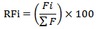 Description:
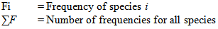
2.2.3. Species Relative Cover (RCi)
 Description:
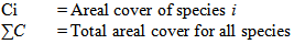 Indicates the Importance Value Index (IVI= RDi + RFi + RCi). It ranges from 0 – 300.
2.2.4. Litter Production
Measurements of litter production were carried out by placing 1 mm-mesh sized litter fall trap (1 x 1 m) under the canopy for 30 days [11]. All litters sustained in the litter fall trap were taken to the laboratory for further analysis. The analysis of leaf litters follows the biomass and carbon guide of SNI 7724:2011.
2.2.5. Physico-chemical Parameters
Physico-chemical parameters (salinity, temperature, visibility, depth, pH and DO) around the mangrove vegetation were measured in-situ and the primary productivity (chlorophyll-a, nitrate and phosphate) was determined by bringing water sample to the laboratory for further analysis. Water sampling and measurement were done 6 times in about 30 day-intervals, repeated 3 times, at three depths, < 5m, 5 -10 m; and > 10m, respectively.
3. Results and Discussion
3.1. Mangrove Vegetation Condition
3.1.1. Mangrove Species Distribution
Mangrove ecosystem consists of many species of mangrove plants and other different plant families. Each species of mangrove possesses different distribution in mangrove vegetation of certain area. Based on mangrove species identification [12] and field observation using Line Tansect Plot method, this study found 5 species of mangroves, A. marina, E. agallocha, N. fruticans, R. apiculata, and S. caseolaris (Table 3).Table 3. Distribution of mangrove species in the study zones
 |
| |
|
Low mangrove diversity in the study site could result from Line Transect Plot method used just covers relatively limited area, depending upon the green belt width of mangrove vegetation area. For instance, Zone I, located at the margin of Seruyan rivermouth (reverine environment), the width of mangrove vegetation are about 0-100 m from the river margin, the area toward the land is a shrub area, while zone II and zone III are located in the margin of coastal line. Zone II has mangrove vegetation area about 0-150 m from the coastal line, and behind the mangrove vegetation is fish pond area. Zone III has mangrove vegetation width only about 0 - 40 m from the coastal line, and behind it is fish pond area.
3.1.2. Mangrove Species Composition and Density
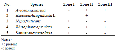
Mangroves possess certain vegetation composition. This vegetation group consists of various species of mangrove plants that can physiologically adapt to specific environment, such as salinity, type of soil, and tides, so that zonation is formed [13]. The composition of mangrove species at tree phase in each study zone can be seen in Figure 3. | Figure 3. mangrove species composition at tree phase in each zone |
One of the zonation types of mangrove forest in Indonesia, on mangrove species basis, viewed from the coast toward the land, the mangrove stand formation are as follows: Avicennia/Sonneratia, Rhizophora, Rhizophora/Bruguiera, Bruguiera, and Nypa fruticans. The nearest area to the sea, with sandy substrates, is often occupied by Avicennia spp. which is associated with Sonneratia spp. dominantly lives in deep mud area rich in organic matters. Toward the land, the mangrove forest is generally dominated by Rhizophora spp. Bruguiera spp. and Xylocarpus spp. were also recorded in this zone, and the next zone is dominated by Bruguiera spp. The last zone is a transitional zone between mangrove forest and low land forests where N. fruticans and several palm trees or other shrubs grow [4].Zone I (Sungai Bakau village). Two species of mangroves were recorded at the tree phase, N. fruticans with 16 individuals and S. caseolaris with seven individuals. Related with the extent of the study zone, the density of mangrove vegetation in zone I is 6 ind/100 m2. Zone II (Kuala Pembuang II village). Three mangrove species at the tree phase were found in this zone, A. marina, 67 individuals, E. agallocha, four individuals, and R. apiculata, four individuals, so that total number of mangroves found was 74 individuals. Related to the width of study zone, the mangrove density in zone II was 15 ind/100 m2. Mangrove species at the sapling phase were E. agallocha, 30 individuals, and R. apiculata, 10 individuals, while those of seedling phase were A. marina and R. apiculata, each of which was only one individual.Zone III (Sungai Gintung village). There was only one mangrove species, A. marina, found at the tree phase, with 30 individuals. If related to the width of observation site, the vegetation density was 10 ind/100 m2. In this zone was found mangrove species at the sapling phase, A. marina, 12 individuals, and 9 individuals of R. apiculata, while at the seedling phase 13 individuals of R. apiculata were recorded.Mangrove species mostly encountered in zone I is N. fruticans, 69.6 % of the total number of species and then S. caseolaris, 30.4% (Fig. 3). Sonneratia caseolaris was mostly found growing close to the margin of rivermouth, while toward the land was occupied by N. fruticans. Both species were recorded almost along the right margin of Seruyan rivermouth. Sonneratia caseolaris existed in muddy sand soil, while N. fruticans was easier found in the muddy soil. It is line with the fact that along the left margin of Seruyan rivermouth is declivous enough with sandy mud substrates. Sonneratia caseolaris is a major mangrove plant growing in the most front of the coastal line or the rivermouth [4]. This species has adapted to the tidal current fluctuations causing flood and salinity variations and forming the pure stand [14]. Otherwise, N. fruticans and shrubs of Scyphiphora spp., Brownlowia spp. and Acrostichum spp. mix-grow in the mangrove forest at various phases, sometimes depending upon the freshwater input and water flood level. These mixed mangrove communities often grow far to hinterland and the coastal characteristics are affected by big river system [15].In zone II, mangrove species at the tree phase mostly found are A. marina, 66 individuals or 89.2% of the total species number. Other species encounterd in small numbers were E. agallocha and R. apiculata, four individuals for each, or 5.4%. Avicennia marina is the most dominant species growing in the margin of coastal line associating with E. agallocha. Towards the land was found A. marina associating with R. apiculata. The substrate type of this zone is slightly muddy sand. Avicennia marina is a major mangrove plant living in the most front line facing the coastal line and could generally grow well in sandy substrate [4]. Excoecaria agallocha is a minor species found at the edge part of the mangrove vegetation on the land or tidal water boundary. Ng and Sivashosi [16] found that R. apiculata prefers humus-enriched soft muddy substrate. In zone III, only A. marina, 30 individuals (100%), was recorded. In this zone, no other mangrove species was encountered due to mangrove areal conversion to fish pond, in which the mangrove clear-cut had reached far to the green belt, and remained 0 – 40 m from the coastal line. So, that the mangrove vegetation zonation occurs only in the closest area to the sea, where A. marina generally grow.
3.1.3. Importance Value Index (IVI)
Importance value index (IVI) calculations were used to assess the extent of roles of each mangrove species in a certain area. Mangrove vegetation zone used for this study is structured by five mangrove species, A. marina, E. agallocha, N. fruticans, R. apiculata and S. caseolaris, with varied IVI (Fig. 4).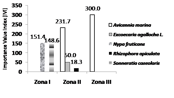 | Figure 4. Importance Value Index (IVI) for mangrove species |
Both S. caseolaris and N. fruticans are similarly dominant in structuring the mangrove vegetation in zone I (Fig. 4). It could be seen from the nearly same IVI value for N. fruticans (151.4) and S. caseolaris (148.6). In zone II, the mangrove structurers consist of A. marina, E. agallocha and R. apiculata. The highest IVI was recorded in A. marina (231.7), followed by E. agallocha L (50.0) and R.apiculata (18.3). Zone III has only one species, A. marina, and the IVI was scored 300.0. Indriyanto [17] claimed that a plant with higher importance value index than other plant species in certain area will dominate the area. Mangrove productivity was 100 gr C/m2 per year in zone I, 63.98 gr C/m2 per year in zone II, and 35.36 gr C/m2 per year in zone III, respectively, calculated from the leaf litters. Study in Sepi Bay, West Lombok, recorded total litter production of 9.9 t d-1 controbuted from R. mucronata of 5.41 t d-1 (5.41 t d-1 (54.7%), followed by R. apiculata of 1.8 t d-1 (18.2%), S. alba of 1.75 t d-1 (17.6%), R. stylosa of 0.92 t d-1 (9.3%) and Aegiceras sp. of 0.02 t d-1 (0.2%) [18]. In mature/adult forest Rhizophora trees, compared with the biomass of stem, branch and bufferring root, the leaf biomass ratio is sufficiently low/small ranging from 0.4 – 29.8 t d-1 [19].
3.2. Water Quality
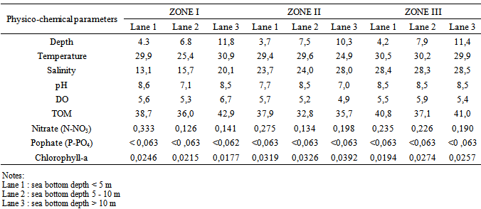
As one of pollution and/or degradation control tools for marine environment, Indonesia Government, through the Minister of Living Environment, issued a decree numbered 51, 2004 [20] concerning seawater quality standard, in which chapter 1 (point 2) states that seawater quality standard is a threshold level where living organisms, substances, energy or components present or must present and/or pollutants allowed to be in the seawater. Further, the chapter 3 (point 3) claimes that water quality standard for marine biota is as mentioned in Appendix 3 of this decree [20]. For this, the measurements of the physico-chemical parameters in the study zone are given in Table 4.Table 4. Physico-chemical measurements at the study zones
 |
| |
|
The physico-chemical parameter measurements in the study zones, such as temperature, salinity, pH, dissolved oxygen, total suspended solid, were compared with similar parameters listed in the Minister’s Decree for Living Environment No: 51, 2004 (Table 4). These measurements still met the provision of the seawater quality standard (Appendix III). Except that nitrate (N-NO3) and phosphate (P-PO4) exceeded the seawater quality standard.
4. Conclusions
Mangrove vegetations in the study sites comprise five species, Avicennia marina, Excoecaria agallocha L, Nypa fruticans, Rhizophora apiculata, and Sonneratia caseolaris. Their composition and density in zone 1 (Sungai Bakau village) at the tree phase were 16 individuals of N. fruticans and seven individuals of S. caseolaris, with a density of 6 ind/100 m2. In zone II (Kuala Pembuang II village), speies composition at the tree phase was 66 individuals of A. marina and four individuals of each E. agallocha and R. apiculata, with a density of 15 ind/100 m2. In zone III (Sungai Gintung village), there were only 30 individuals of A. marina cover, with a density of 10 ind/100 m2.Regarding Importance Value index (IVI), in zone I, it was 151.4 for N. fruticans and 148.6 for S. caseolaris. In zone II, the highest IVI occurred A. marina (231.7), followed by E. agallocha (50.0) and then R. apiculata (18.3). In zone III, since A. marina was the only species inhabiting the area, the IVI was 300.0. Mangrove productivity per year was 100 gr C/m2 in zone I, 63.98 gr C/m2 in zone II and 35.36 gr C/m2 in zone III. In addition, all physico-chemical parameters, but nitrate (N-NO3) and phosphate (P-PO4), still met the provision of Minister’s Decree for Living Environment No. 51, 2004.
ACKNOWLEDGEMENTS
We thank Raival, Ufik, Tono and Hendri, students of Study Program of Aquatic Resources Management, Faculty of Agriculture, Palangkaraya University, for their assistence during the field data sampling.
References
| [1] | Central Statistics Agency (BPS), Central Kalimantan, 2013, Central Kalimantan in Numbers 2013, Government of Central Kalimantan, Indonesia. |
| [2] | Central Statistics Agency (BPS), Seruyan Regency, 2013, Seruyan in numbers 2013, Government of Seruyan, Indonesia. |
| [3] | Manson, F.J. , Lorenagan, N.R., Skilleter, G.A., Phinn, S.R., 2005, An evaluation of the evidence for linkages between mangroves and fisheries: a synthesis of the literature and identification of research directions, Journal Oceanography and Marine Biology: an Annual Review, 43, 485-515. |
| [4] | Bengen, G.D., 2004, Synopsis of coastal and sea resources ecosystem and its principle management, PKSPL, Bogor Agricultural University, Bogor, 72 p. |
| [5] | DKP of Seruyan Regency, 2013, Fisheries Statistics of Seruyan Regency, Seruyan Government. |
| [6] | Primavera, J.H., 2005, Mangroves, fishponds, and the quest for sustainability, Science, 310, 57–59. |
| [7] | Moberg, F., Rönnbäck, P., 2003, Ecosystem services of the tropical seascape: interactions, substitutions and restoration, Ocean Coast. Manage., 46, 27–46. |
| [8] | Walters, B.B., Rönnbäck, P., Kovacs, J.M., Crona, B., Hussain, S.A., Badola, R., Primavera, J.H., Barbier, E., Dahdouh-Guebas, F., 2008, Ethnobiology, socioeconomics and management of mangrove forests: A review, Aquat. Bot., 89, 220–236. |
| [9] | Decree of Environment Ministry, No. 201/2004 on Standard Criteria and Guideline of Mangrove Damage Determination. |
| [10] | Bakosurtanal, 2005, Survey guideline and mangrove mapping, Survey Centre of Sea Natural Resources, Bogor. |
| [11] | Sutaryo, D., 2009, Biomass calculations, an introduction to Carbon Study Trading, Wetland International Indonesia Program. |
| [12] | Giesen, W., Wulffraat, S., Zieren, M, S., Scholten, L., 2007, Mangrove guidebook for Southeast Asia, FAO and Wetland International, 511 p. |
| [13] | Blasco, F., 1992, Outlines of ecology, botany and forestry of the mangals of the Indian subcontinent, Chapman, V.J., (Ed.), Ecosystems of the World 1: Wet Coastal Ecosystems, Elsevier, Amsterdam. |
| [14] | Tomlinson, C.B., 1986, The botany of mangroves, Cambridge University Press, Cambridge. |
| [15] | Brown, B., 2007, Resilience thinking applied to the mangroves of Indonesia, IUCN and Mangrove Action Project, Yogyakarta, Indonesia, 52 p. |
| [16] | Ng, P.K.L., and N. Sivasothi (Ed.), 2007, A guide to mangroves of Singapore, Volume 1: The Ecosystem and Plant Diversity and Volume 2: Animal Diversity, The Singapore Science Centre, Singapore. |
| [17] | Indriyanto, 2006, Forest Ecology, PT Bumi Aksara, Jakarta, 165-170 p. |
| [18] | Zamroni, Y., and Rohyani,I.S., 2008, Litterfall production of mangrove forest in the beach waters of Sepi Bay, West Lombok, Biodiversitas, 9(4), 284-287. |
| [19] | Komiyama, A., Ong, J.E., Poungparn, S., 2008, Allometry, biomass, and productivity of mangrove forests: A review, Aquatic Botany, 89, 128–137. |
| [20] | Decree of Environment Ministry, No. 51/2004 on Quality Standard of Sea Water, Appendix III. |
 Abstract
 Reference
 Full-Text PDF
 Full-text HTML