-
Paper Information
- Next Paper
- Previous Paper
- Paper Submission
-
Journal Information
- About This Journal
- Editorial Board
- Current Issue
- Archive
- Author Guidelines
- Contact Us
International Journal of Ecosystem
p-ISSN: 2165-8889 e-ISSN: 2165-8919
2012; 2(5): 99-102
doi: 10.5923/j.ije.20120205.03
Gamma Shooting of the Territory of Municipal Landfill of the Dushanbe City
 Abstract
 Reference
 Full-Text PDF
 Full-Text HTML
D. A. Abdushukurov 1, G. B. Anvarova 2, D. V. Bondarenko 3, B. N. Mamadaliev 4, D. F. Stotsky 5
1Leading researcher, Physical Technical institute of Academy of Sciences, Dushanbe, Tajikistan
2PhD student, Physical Technical institute of Academy of Sciences, Dushanbe, Tajikistan
3Physical Technical institute of Academy of Sciences, Dushanbe, Tajikistan
4Director of NGO «Tabiati Toza», Dushanbe, Tajikistan
5Committee on Emergency Situations, Dushanbe, Tajikistan
Correspondence to: D. A. Abdushukurov , Leading researcher, Physical Technical institute of Academy of Sciences, Dushanbe, Tajikistan.
| Email: |  |
Copyright © 2012 Scientific & Academic Publishing. All Rights Reserved.
The rearrangement of Municipal landfill of Dushanbe city has begun; in this connection the gamma and neutron shooting of territory of landfill has been made. The landfill territory has been divided into 128 routes, and it has been conducted 5691 measurements of gamma background. The gamma background in territory is defined by background from environing soils 0.18±0.02 µZv/h and background from low-active wastes 0.11±0.02 µZv/h. During conducting gamma shooting the ownerless gamma source Cesium-137, with equivalent dose rate 40 µZv/h, has been detected. For localization and source extraction specialists of Committee on emergency situations under government RT and Agency on Radiation and Nuclear Safety at Academy of Sciences RT have been invited. Fluency of neutrons on surface does not exceed background values and that testifies about absence of neutron sources.
Keywords: Gamma Shooting, Neutron Shooting, Gamma’S Background, an Ownerless Radioactive Source, Municipal Landfills
Article Outline
1. Introduction
- After collapse of the USSR the centralized monitoring system over storage and disposal of radioactive sources in Tajikistan has been destroyed. And only after 11 years, in 2003 the Agency on Control for Radiation and Nuclear Safety has been created. During the civil war years and after it there could be events of losses or illegal disposal of radioactive nuclear sources at the Republic factories. For the purpose of search of ownerless radioactive sources IAEA financed the project of the Agency on Radiation and Nuclear Safety. Recently the decision on rearrangement of Municipal landfill (ML) of Dushanbe city was made. Within the limits of rearrangement it is supposed to carry out a soil covering of a surface of a landfill dump. Before realization of these works there was a necessity of conducting gamma and neutron shooting of a surface of a landfill, for the purpose of detection of illegally buried of ownerless sources. ML of Dushanbe city is located in its southeast part, in 12 km from the centre and 2 km from a route of Dushanbe - Vahdat, fig. 1. The relief of territory of a dump represents complex undulating system with comparative deep ravine, sometimes with steep slopes, with a grade from 5-10° to25-30°. The territory is located at altitudes 870 - 930 m above sea level. Landfill exploitation has begun in 1977. The landfill total area makes more than 20 hectares, the maximum depth of a body of landfill exceeds 30 m. Territory of landfill has no accurately certain boundary lines and fences. The landfill surface was not covered with a ground for many years, therefore all working zone for today is accessible.
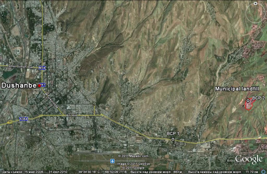 | Figure 1. The map shows the localization of Municipal landfill in the southeast of Dushanbe. The map was made by means of program Google Earth [6] |
2. Method of Conducting of the Gamma Shooting
- Preliminary reconnaissance investigations of the ML were carried out before beginning of works. With shuttle route landfill and its natural complex were familiarized, correctness and conformity of a modern situation with topographic maps were checked. Landfill contours were plotted, wind rose beam directions defined. Two basic monitoring points (BMP), for the monitoring over correctness of work of dosimeters have been chosen. The first place of BMP was chosen in territory of Physical Technical institute in 4 km from landfill, the second place was chosen near to a landfill office building. Chosen BMPs were noted on a district map. The topographic grid was put on the map-scheme of landfill with step of 5 meters, fig. 2. The grid has been tied up to outstanding points on locality (electric poles) and fixed in the working notebook. A knot of this topographic grid has been numbered. In an aspect of relief complexity the itineraries for access the measurement points were chosen. The beginning and the end of a grid, a position of monitoring knots on it and coordinate of BMPs were measured by means of the GPS-navigator and were recorded in the notebook.
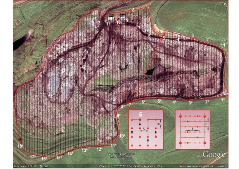 | Figure 2. Map of the distribution of itineraries of measurements. The map was made by means of program Google Earth [6] |
3. Results of Measurements
- During the performed works 5691 measurements of gamma background in the points has been registered. Landfill has been divided into 128 lines of measurements - routing lines least of which was 75 meters and the greatest - 355 meters. Gamma background on a surface of soils equals 0.18±0.02 µZv/h, and this background is typical for a Dushanbe city and its neighbourhoods. Background measurements on BMP points have shown similar values, 0.18 µZv/h near Physical Technical institute and 0.19 µZv/h near office building of ML, measuring points were placed on distance more than 20 meters from structures. The wastes on landfill in the basic consist of pieces of polyethylene, glass, paper and rag scraps, and also food wastes. At unloading of wastes from trucks all visible metals (black and colour), polyethylene tare and large plastic products was being collected, for recycling. The remained wastes are slightly radioactive and their gamma background does not exceed 0.11±0.02 µZv/h, fig. 3. Considering the big square of an urban dump - more than 20 hectares, 20 days have been spent for conducting of a field work. Results of measurements are introduced in drawing 4. At measurement the ground roads with background of 0.16-0.20 µZv/h were clearly visible. Ground roads edged a dump boundary line, also there are the inner roads with the raised background presented.
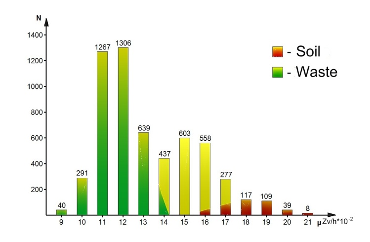 | Figure 3. Distribution of gamma background on Equivalent Dose Rate depending on quantity of measuring points |
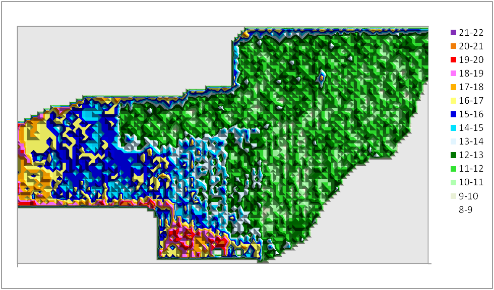 | Figure 4. Distribution of gamma background on landfill territory in µZv/h*10-2 |
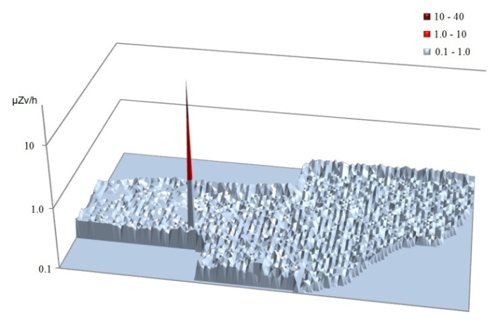 | Figure 5. Tridimensional bar graph of distribution gamma background on a surface of landfill. The point matching to the found source is clearly visible |
4. Conclusions
- In connection with forthcoming rearrangement of the Municipal landfill of Dushanbe city the gamma and neutron shooting of a surface of landfill has been made. During the performed works 5691 measurements of gamma background in the points has been registered. Landfill has been divided into 128 lines of measurements - routing lines least of which was 75 meters and the greatest - 355 meters. Gamma background of adjoining soils equal 0.18±0.02 µZv/h and wastes equal 0.11±0.02 µZv/h were measured. Gamma background on a dump varied dependent on these two values and varies with changes of waste thickness too. The neutron background in all territory of a dump did not exceed background values, which testify the absence of disposal of neutron sources. During shooting the ownerless illegally buried gamma source of Cs-137, with EDR on a surface 40 µZv/h was detected. For liquidation of the emergency situation specialists of Committee on Emergency Situations under Government of Republic Tajikistan and Agency on Nuclear and Radiation Safety at Academy of Sciences have been invited. The source has been taken, placed in to the container and carried out to laboratory of Agency for identification and the subsequent disposal. In the conclusion authors express gratitude to specialists of Committee on Emergency Situations under Government of Republic Tajikistan and Agency on Nuclear and Radiation Safety of Academy of Sciences of Republic of Tajikistan for the help and participation in process.