-
Paper Information
- Paper Submission
-
Journal Information
- About This Journal
- Editorial Board
- Current Issue
- Archive
- Author Guidelines
- Contact Us
International Journal of Agriculture and Forestry
p-ISSN: 2165-882X e-ISSN: 2165-8846
2021; 11(1): 9-15
doi:10.5923/j.ijaf.20211101.02
Received: Feb. 24, 2021; Accepted: Mar. 24, 2021; Published: Apr. 25, 2021

Characterization of Historical and Future Drought in Central Uganda Using CHIRPS Rainfall and RACMO22T Model Data
 Abstract
 Reference
 Full-Text PDF
 Full-text HTML
Mabel Najjuma1, Alex Nimusiima2, Geoffrey Sabiiti3, Ronald Opio4
1Uganda National Meteorological Authority, Kampala, Uganda
2Meteorology Unit, Makerere University, Kampala, Uganda
3IGAD Climate Prediction and Applications Centre, Nairobi, Kenya
4WIMEA-ICT Lab, Makerere University, Kampala, Uganda
Correspondence to: Mabel Najjuma, Uganda National Meteorological Authority, Kampala, Uganda.
| Email: |  |
Copyright © 2021 The Author(s). Published by Scientific & Academic Publishing.
This work is licensed under the Creative Commons Attribution International License (CC BY).
http://creativecommons.org/licenses/by/4.0/

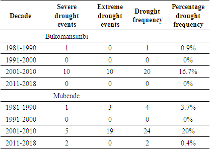
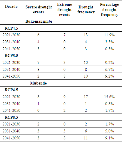
Drought is one of the devastating natural events that affect sensitive sectors such as crop production. The overall aim of this study was to characterize historical and future drought in two districts located within Uganda’s coffee growing region, that is Bukomansimbi and Mubende. The standardized precipitation index (SPI) was applied to both historical and model-projected future rainfall in order to characterize the drought events. Data from the Climate Hazards Group InfraRed Precipitation (CHIRPS) provided the historical rainfall observations while future rainfall for the period2021 to 2050 was obtained from projections of version 2.2 of the Regional Atmospheric Climate Model (RACMO22T). The results showed that for the historical period, the decade 2001 to 2010 had the highest drought frequency of 16.7% in Bukomansimbi and 20% in Mubende. It also had the highest records of drought duration, magnitude and intensity, and the pinnacle of these events was in the period 2005 to 2007. The future drought characterization showed that the decades 2021 to 2030 and 2041 to 2050 are anticipated to have the highest drought frequencies, which for RCP 4.5 are 11.9% in Bukomansimbi and 15.6% in Mubende while for RCP 8.5 they are 9.2% in Bukomansimbi and 9.1% in Mubende. It is likely that drought will decrease in the future periods, and thus loosen its grip on the most affected sectors such as crop production.
Keywords: Drought, Standard Precipitation Index, Uganda
Cite this paper: Mabel Najjuma, Alex Nimusiima, Geoffrey Sabiiti, Ronald Opio, Characterization of Historical and Future Drought in Central Uganda Using CHIRPS Rainfall and RACMO22T Model Data, International Journal of Agriculture and Forestry, Vol. 11 No. 1, 2021, pp. 9-15. doi: 10.5923/j.ijaf.20211101.02.
Article Outline
1. Introduction
- Drought is one of the most catastrophic types of natural disasters, causing damage in the order of billions of US dollars to the farming community worldwide each year (FAO, 2017; Zhou et al., 2018). Agriculture is one of the sectors most affected by this phenomenon in that it causes long term shortage of water and extreme heat stress in crops, thus damaging them especially if the event occurs during vulnerable times of the plant life-cycle (FAO, 2017). Drought stands out among natural disasters because it affects wide regions and extends over long periods of time, thus having disastrous impacts (Eslamian et al., 2017). In many developing regions of the world such as in East Africa, drought impedes production and income at a household level which in turn affects peoples’ overall output and welfare (Gebremeskel et al., 2019). At a country level, severe drought has the potential to affect the gross domestic product and undermine a country’s development efforts. This is much more pronounced in third world countries like Uganda where agriculture is a major pillar of the economy. Drought is an important topic in Uganda’s farming regions, and that is no exception for the coffee growing regions. With about 1.7 million smallholder farmers involved in coffee farming (Mulinde et al., 2019), occurrence of prolonged drought events can have disastrous implications on their income and well-being. The interest of this work, therefore, is to characterize drought in these coffee growing districts of the country and to understand its trend in both the historical and future perspectives.Understanding and assessing the drought occurrences is an essential element in any country’s drought management plan because it reduces on the production losses that may lead to the reduction of government tax revenues (Adhyani et al., 2017). So far, in Uganda, Mulinde et al. (2016) has done a scientific analysis of drought events covering the period 1943 to 1982. This leaves the question of the recent drought trends unanswered. This study therefore seeks to establish the recent and future drought trends in Central Uganda. Furthermore, for Uganda to achieve its commitment in the 2030 Agenda particularly on climate action, it is essential for the country to understand the dynamics of climate-related natural disasters such as drought.
2. Materials and Methods
- Study areaThe study was conducted in Mubende and Bukomansimbi which are main Robusta coffee growing districts in Central Uganda (Figure 1). The total population of Bukomansimbi district is 151,413 and households that depend on crop growing as the main source of livelihood are approximately 93% (Uganda Bureau of Statistics, 2017a). In Mubende, the total population is 684,348 and households engaged in crop growing are 89.3% (Uganda Bureau of Statistics, 2017b). In Central Uganda, the rainfall pattern is bimodal, having two seasons. The long rain season is from March to May (MAM) and the short rain season is from September to November (SON). The climatological zones in which Bukomansimbi lies receives an average annual rainfall amount of 1408.2mm, its maximum temperature ranges from 26.78 to 29.43°C and its minimum temperature ranges from 15.69 to 17.53°C. On the other hand, the zone in which Mubende lies receives 938.8mm of rainfall, its maximum temperature ranges from 26.17 to 27.65°C and its minimum temperature ranges from 13.41 to 14.40°C (Majaliwa et al., 2015). These districts were chosen for the study because there have been reports such that by Ssekweyama and Nakkazi (2019) that highlight them as being severely affected by drought. They also lie in the drought prone cattle corridor of Uganda.
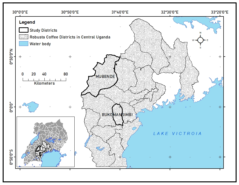 | Figure 1. The position of Mubende and Bukomasimbi among the coffee growing districts in Central Uganda |
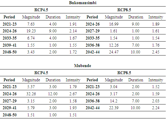
 was then calculated using equation 1. This calculation was applied to each year of the data series for both the historical and future periods, and results were categorized as shown in Table 1. In this work, emphasis was placed on the severe and extreme drought events because they potentially have more disastrous consequences on human livelihood.
 | (1) |
|
 by the total number of months of the study,
  and then multiplied by 100, as shown in equation 2.
  | (2) |
 | (3) |
 and dependent variable,
  the linear regression equation takes the form of equation 4, in which
  is a constant and
  is the slope (Wilks, 2019). The
  determinant appended onto the results gives an indication of the strength of the relationship, it ranges from 0 to 1, and the closer the value is to 1, the stronger the relationship.
 | (4) |
3. Results and Discussion
- Drought characteristics for the historical periodIn figure 2 (a) and (b) the SPI index shows a similar pattern at both locations with notable variation across the years. It was observed that in both districts, the period 2004 to 2008 had the extreme and severe drought events, although in 2005 Mubende recorded a slightly higher extreme event (SPI = -2.8) than Bukomansimbi (SPI = -2.2).
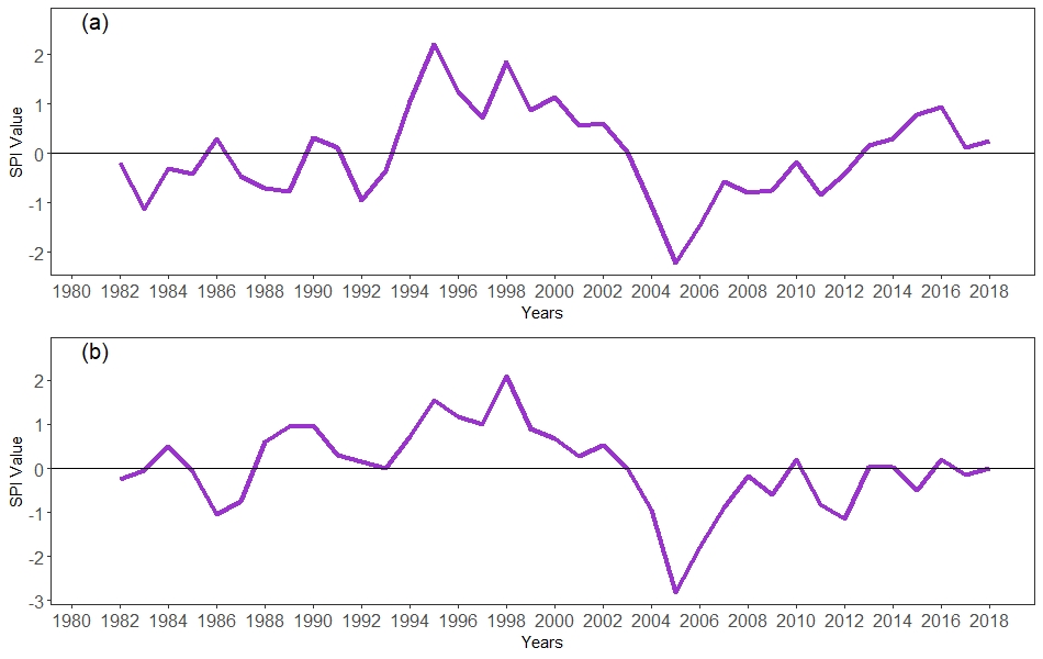 | Figure 2. Average Standardized Precipitation Index (SPI) for Bukomansimbi (a) and Mubende (b) |
|
|
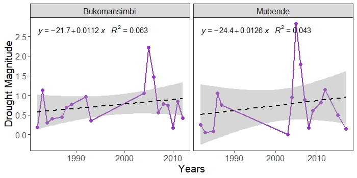 | Figure 3. Historical drought trend in Bukomansimbi and Mubende |
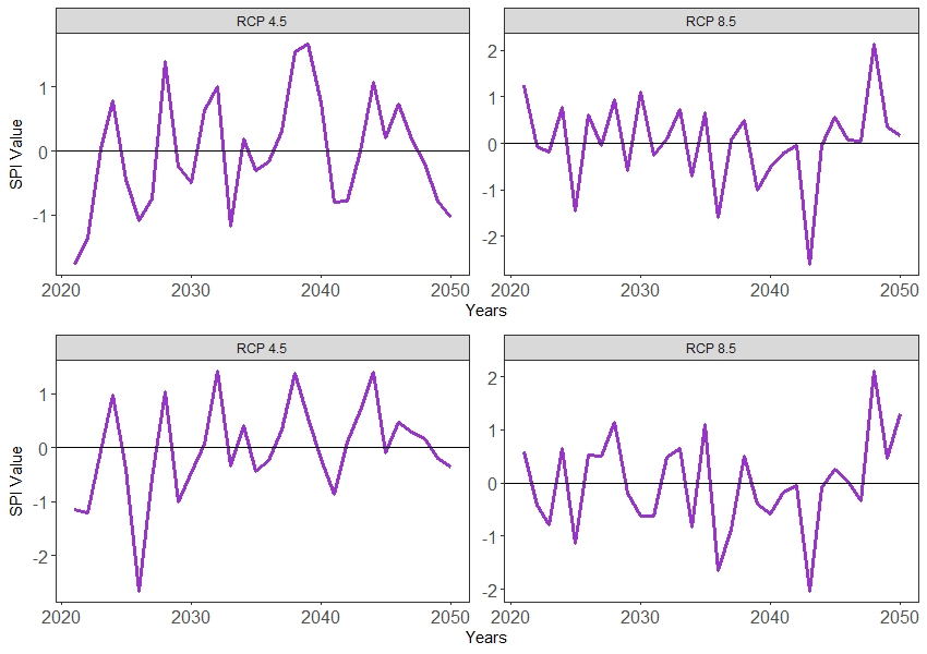 | Figure 4. Projected drought magnitude for Bukomansimbi (upper row) and Mubende (lower row) under RCP 4.5 and RCP 8.5 emission pathways |
|
|
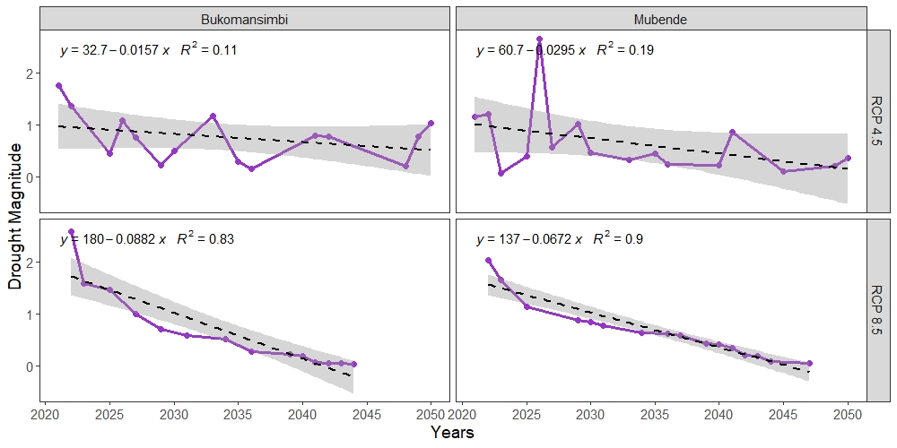 | Figure 5. Trends of projected drought for Bukomansimbi and Mubende under RCP 4.5 and RCP 8.5 |
4. Conclusions
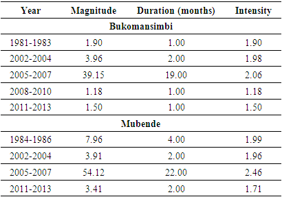
- For the historical period, 1981 to 2018, the analysis revealed that the 2-year period from 2005 to 2007 was the peak of the drought events, having intensities of over 2. Also, during this period, Mubende experienced drought events of a higher magnitude, lasting over longer periods and with higher intensities compared to Bukomansimbi. Now during the future period, 2021 to 2050, the model projections reveal that under the low emission scenario (RCP 4.5), this situation could remain the same, however, under the high emission scenario (RCP 8.5), it is likely that Bukomansimbi could turn out to have stronger drought cases than Mubende. This affirms society’s fears of climate change causing a shift in the spatial and temporal dynamics of natural disasters. Furthermore, since a decline in drought magnitude is projected under the high emission pathway, drought affected sectors such as agriculture could be alleviated from their severe impacts and consequently experience an increase in production. It is also possible that drought will most likely be a topic drawing lesser attention in future years.
ACKNOWLEDGEMENTS
- Rainfall data for this work was provided by the Climate Hazards Group InfraRed Precipitation with Station data (https://www.chc.ucsb.edu/data/chirps) and the KNMI regional atmospheric climate model RACMO, version 2.2.