-
Paper Information
- Previous Paper
- Paper Submission
-
Journal Information
- About This Journal
- Editorial Board
- Current Issue
- Archive
- Author Guidelines
- Contact Us
International Journal of Agriculture and Forestry
p-ISSN: 2165-882X e-ISSN: 2165-8846
2015; 5(3): 182-189
doi:10.5923/j.ijaf.20150503.02
Rangeland Biodiversity: Interrelationships of Stocking Density and Grazing Intensity
 Abstract
 Reference
 Full-Text PDF
 Full-text HTML
Carmelito C. Valdez
Faculty, Ifugao State University – College of Agriculture and Forestry, Potia Campus, Alfonso Lista, Ifugao, Philippines
Correspondence to: Carmelito C. Valdez, Faculty, Ifugao State University – College of Agriculture and Forestry, Potia Campus, Alfonso Lista, Ifugao, Philippines.
| Email: |  |
Copyright © 2015 Scientific & Academic Publishing. All Rights Reserved.
This study aimed to assess the interrelationships of biodiversity with stocking density and grazing intensity in the rangelands of Ifugao Province. Taking into consideration rangeland management practices and climate, this study exhaustively characterized the rangelands or silvipastoral systems of Ifugao Province, identified the plant species (grass and trees) and determined their composition per unit area of the selected rangelands. The biodiversity indices of the various rangeland conditions had been correspondingly estimated.
Keywords: Stocking Density, Grazing Intensity, Biodiversity
Cite this paper: Carmelito C. Valdez, Rangeland Biodiversity: Interrelationships of Stocking Density and Grazing Intensity, International Journal of Agriculture and Forestry, Vol. 5 No. 3, 2015, pp. 182-189. doi: 10.5923/j.ijaf.20150503.02.
1. Introduction
- Rangeland management as a discipline skillfully applies an organized body of knowledge accumulated by range science for two purposes: (1) protection, improvement, and continued welfare of the basic resources (soils, vegetation, endangered plants and animal species, wilderness, water, and historical sites) in a sustainable way, and (2) optimum production of goods and services in combinations needed by society in a more multiple fashions (the harmonious use of range land resources for more than one purpose, such as livestock, recreation, wild life, water production, and others) Fikre et al. (2010). Grazing has been reported to reduce the diversity of herbs and shrubs in the rangeland. Due to overgrazing, the vegetation species composition, richness and productivity has changed over the past decades, some species have disappeared (Darau et al., 2005) while others have survived through the use of morphological or other adaptations (Blench and Sommer, 1999, Gitay et al., 2002, Ali-Shtayeh and Salahat, 2010). Because of decline of natural species in the area, rangeland managers will tend to grow other species that will help supply forage needed by the animals that will lead to species invasion (Del Pozo et al., 2006). Rangeland management techniques intend to increase forage production through increase perennial species (Abraham et al., 2009) that is potential to increase above and below ground soil carbon stocks. Grice et al. (2006) and FAO (2009) found out that rangeland stores thirty (30%) percent of the world’s soil carbon and it is estimated that it could globally sequester 0.35-0.55Gt-C. per year up to 2030. Likewise, FAO (2009) observed that natural and improved fallow systems under agroforestry and managed for resting of lands has potential sequestration rates of 0.1-5.3 T-C. per hectare per year. Objectives of the StudyGenerally, this study aimed to assess the interrelationships of biodiversity with stocking density and grazing intensity in the selected rangelands of Ifugao Province. Specifically, this study has the following objectives:1. Characterize the rangelands or silvipastoral systems of Ifugao Province;2. Identify the plant species (grass) of the selected rangeland in Ifugao Province;3. Determine the biodiversity indices under various rangeland conditions.
2. Methodology
- Research DesignThe rangeland that serves as the research site was strategically identified by the researcher with the assistance of the rangeland officer of the Community Environment and Natural Resources Office (CENRO) of Alfonso Lista, Ifugao. Study sites were based from the density of the rangeland (number of stocks and total area) available at the CENRO-Alfonso Lista followed by actual validation of the data. There are three quadrats established in each of the site representing Heavily Grazed Ecoystem (HG); Partially Grazed Ecosystem (PG) and Recently No-grazing Ecosystem (NG). Selected rangelands were located in adjacent Barangays/Villages of the same climatic condition. Location and Duration of the StudyThe study was conducted in the three selected rangelands in Alfonso Lista, Ifugao (Figure 2) namely; FLGA No.572 situated at Barangay Namillangan, Alfonso Lista, Ifugao, FLGA No.19-2007 located at Barangay Caragasan, Alfonso Lista, Ifugao and FLGA No.743 located at Sitio Pabalay, Barangay Namillangan, Alfonso Lista, Ifugao. The study was accomplished within six months starting from proposal conceptualization on April 2012 up to September 2012.Data Gathering Techniques and ToolsThe criteria in the selection of specific rangeland that served as the study site were based on the stocking density of the rangelands as well as the grazing intensity. Density of rangeland was based on the following criteria: (1) low density if ratio of number of stock and the rangeland area (m2) is 1: above 20, 000; (2) moderate density and (3) high density if the ratio of number of stock and the area (m2) of rangeland is 1: 11, 000-20, 000 and 1: 10, 000 below, respectively.Vegetative and species composition of the rangelands were determined by ecosystem stratification. There are three ecosystems commonly considered in the three rangelands such as: (1) Heavily Grazed Ecosystem (HG) which is characterized as grazing of cattle is throughout the year, (2) Partially Grazed Ecosystem (PG) is cattle grazing in the area for five months and below, and (3) Recently No-grazing Ecosystem (NG) is a rangeland with no grazing in the area for at least five months. Considering sampling intensity and consistency, site reconnaissance was done to identify the points where plots in each ecosystem were established. Plots in square meter method (Darau et al., 2005) as shown below are enclosed in a 25 meters by 25 meters quadrant (Wanner, 2009) where vegetation analysis was done.
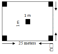 Set-up of the quadrat and the plots for the study.Data Processing and AnalysisIndex of diversity, species evenness, dominance, and relative abundance of species and plant diversity was calculated with Shannon techniques as follows:
 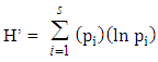 where:H’= Index of diversitypi = ni /N = Relative Abundance s = total number of speciesni = number of individuals in each speciesN = total number of individuals of all speciesIndex of diversity is ranging from 0 (Low community complexity) to 4 (High community complexity). The data gathered was processed using codes and encoded in the Microsoft Excel Program. Through this software, descriptive analyses such as means, frequency, and percentages, was undertaken and subsequently to be transformed to tables and graphs.
 3. Results and Discussion
- A. Physical Characteristics of the Study Sites1. General profile of the Low Density Rangeland The study site (Study Site 1) located at Barangay Caragasan, Alfonso Lista, Ifugao has an approximate area of 100 hectares. The area is under Forest Land Grazing Management Agreement (FLGMA No. 19-2007) for 25 years started on November 27, 2007 and up to December 31, 2032. At present, the rangeland has a stoking rate of 37 cow heads (Low Density). It is bounded on the north by timberland project 5-D, on the eastern part is alienable and disposable land BLK I, Project 5-B, on the south is timberland and on the west is the Cosili River. Some part of the area is devoted for food production with an area of approximately 5 to 6 hectares on the northern part of the pasture area. The area to graze is 85 hectares and the remaining area is devoted to protection or watershed part of the rangeland area.a). Vegetation and topography. The pastureland is dominantly grown to Amorseco, Carabao grass, Cogon and Samsamon. Shrubs and trees to include are Hagonoy, Subsuban, Guava, Lagundi and other pioneer species like Anabiong, Tebbeg, Hauili and Is-is.The general terrain of the area is rolling and more or less categorized as follows: 5 hectares has slope with 18 percent below, 90 hectares with 19-50 percent and 5 hectares having 51 percent and above slopes. b). Soil and water supply. The general soil type of the area is clay loam to sandy loam particularly along creeks and it is semi black to brownish in color. The effective soil depth ranges from 25-65 centimeters (DENR-CENRO, 2012).There are seven creeks and one water impounding located at the north part of the pasture area. Out of seven creeks on the study site, five are all year round that would supply water for the animals all throughout the year.c). Accessibility. The pasture area could be reached through hiking for about 10 to 20 minutes from the national road with a distance of about one kilometer from the high way. The existing farm road however, is passable to four-wheeled vehicle when well improve (i.e., when surface gravelling is undertaken) usually for easy transport of the animals to and from the national road (DENR-CENRO, 2012).d). Existing improvement. The rangeland has been set up to five layers of barbed-wire perimeter fence that would control the animals from getting out from the area and avoiding to destroy neighboring properties particularly agricultural crops. A corral is also constructed on the southern part of the pasture.2. General profile of the Medium Density RangelandStudy site 2 is located at Sitio Pabalay, Barangay Namillangan, Alfonso Lista, Ifugao with an approximate area of 50 hectares. The area is under Forest Land Grazing Management Agreement (FLGMA No. 572-2007) for 25 years which started on November 2007 and expires on December 31, 2032. At present, the rangeland has a stocking rate of 48 cow heads which is considered as having a medium stocking density.It is bounded by the North by open grassland, to the east by barangay road to sitio Pabalay, to the south by PLA No. 431 and to the west by the provincial road of Ifugao.a). Vegetation and topography. The area is dominated by cogon, amorseco, trigo-trigohan and carabao grass. Generally, the area is rolling to slightly rugged in slope. The topography of the area consisted of 15 hectares under the 18 percent slope and below category while the remaining 35 hectares falls within 19 percent and above category.b). Soil and water supply. The soil varies from clay loam to sandy loam. The source of water is a spring which provides continuous water throughout the year. There are also five fishponds established in the area serving as reservoirs of water. Two fish ponds are supported by water pump connected to the spring that serves as source of water for the cattle during summer specifically when water supply is limited.c). Accessibility. Aside from the provincial road which serves as the area boundary on the southern and western portion, there are also trails which radiates from the barangay road from the Sitio Pabalay going to the cowboy/ranchers quarter about 200 meters in length.The presence of these trails and roads make the area accessible anytime of the season.d). Existing Improvements. The area is well secured having a perimeter fence of five layers barbed-wire with three layers of barbed-wire in each of the three compartments. A part of this rangeland, with an area of more or less five hectares, was developed into different land-uses such as; mango plantation, a corn production area and vegetable production area, aside from being used as grazing area for the animals. This practice of maintaining different land uses in the rangeland would definitely generated additional income to the manager-owner (DENR-CENRO, 2012). 3. General profile of the High Density Rangeland Study site 3 is located at Namillangan Proper, Alfonso Lista, Ifugao, with an approximate area of 50 hectares. The area is under Forest Land Grazing Management Agreement (FLGMA No. 743-2007) for 25 years started on August 6, 1997 up to December 31, 2022. At present the rangeland has a stoking rate of 63 cow heads (High Density).It is bounded by the North by a provincial road going to Barangay Calupaan, on the west by a development site to be undertaken by the National Housing Authority and the south east is the NIA Dam and Reservoir of Ramon, Isabela.
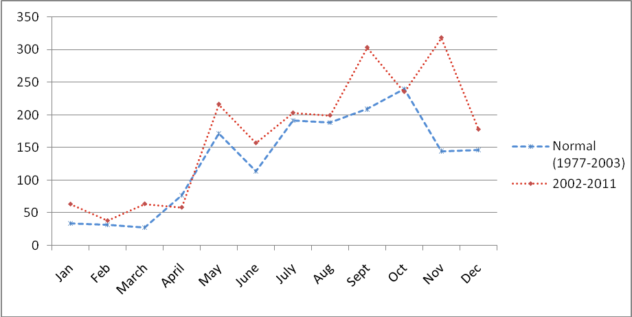 | Figure 1. Average monthly and annual rainfall (mm) in the study site |
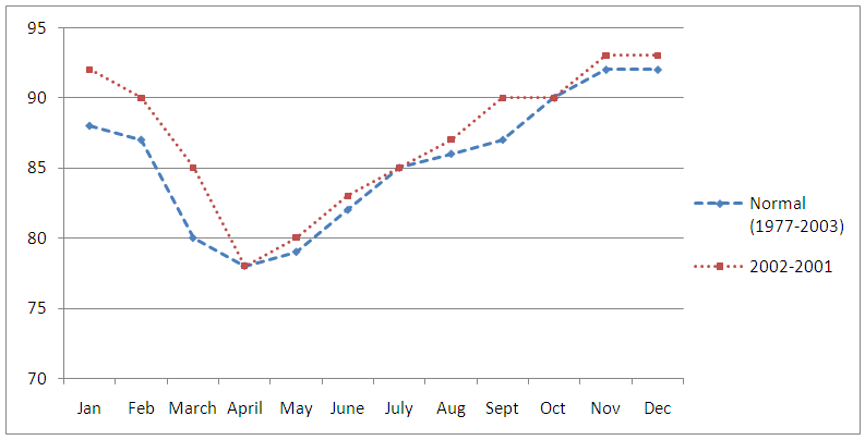 | Figure 2. Average monthly and annual relative humidity |
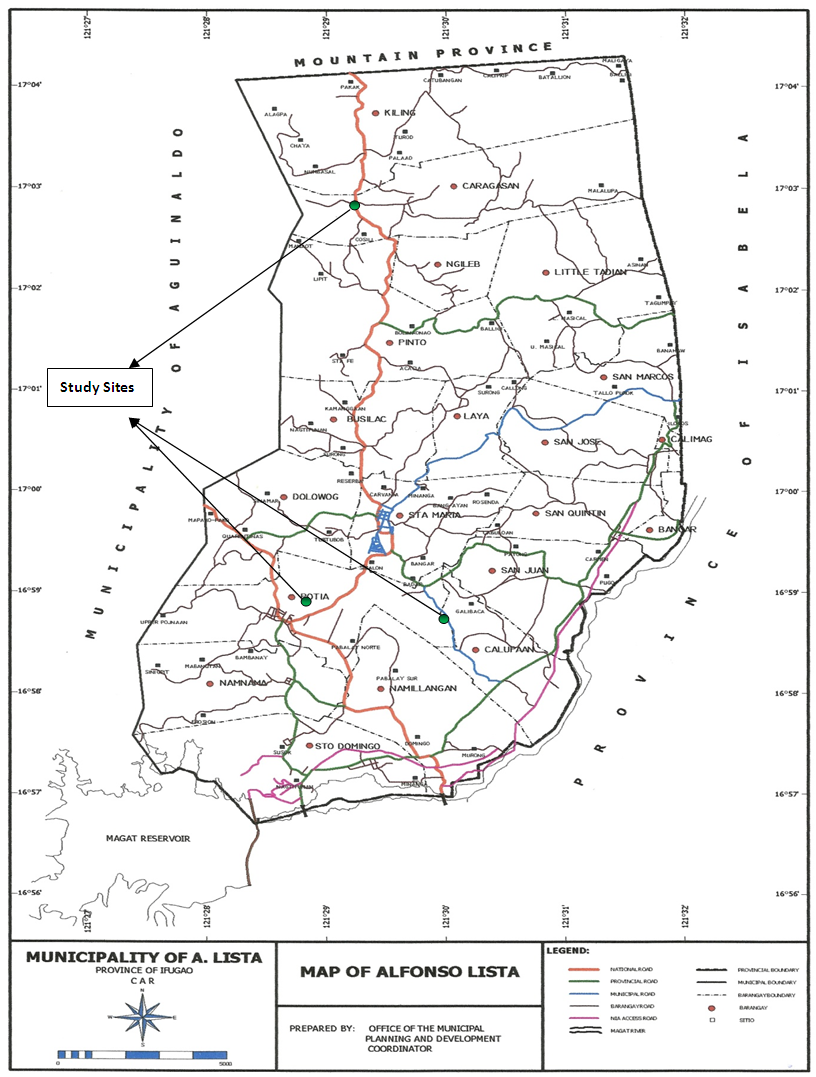 | Figure 3. The study sites |
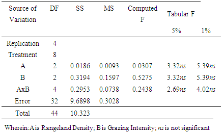
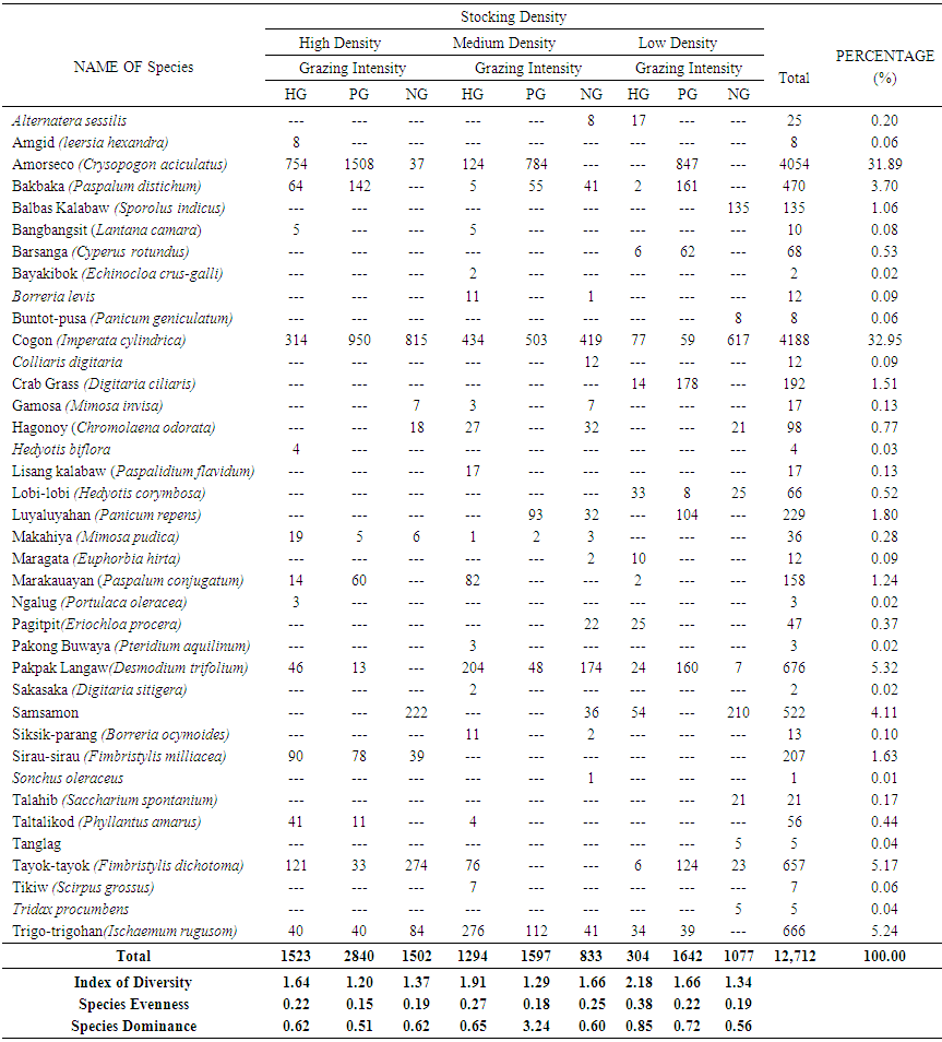 | Table 1. Overall results of the assessment of rangelands' biodiversity in Ifugao Province (HG=heavily Grazed; PG=Partially Grazed; NG=No Grazing) |
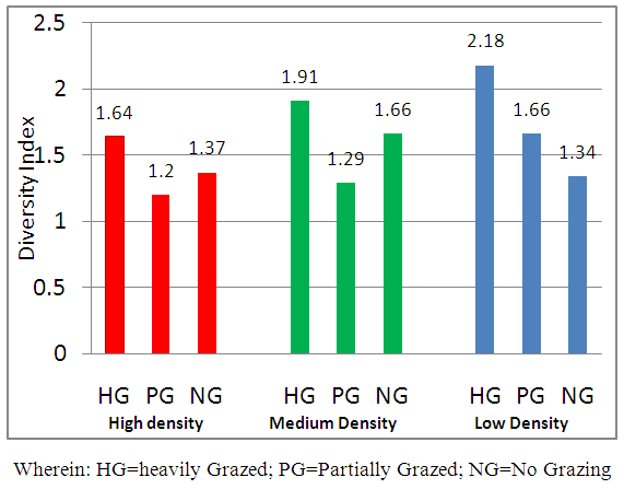 | Figure 4. Biodiversity indices in relation to grazing intensity |
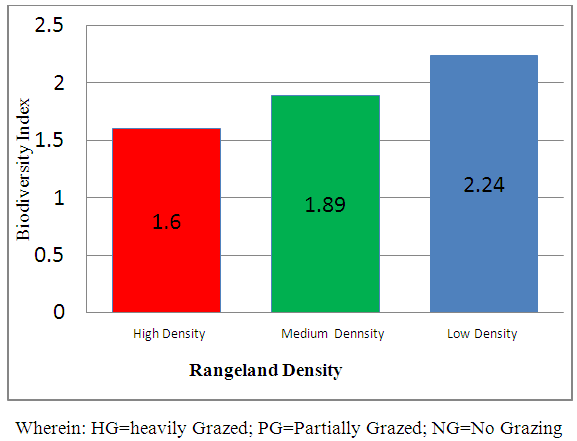 | Figure 5. Biodiversity Indices in Relation to Stocking Density |
|
ACKNOWLEDGEMENTS
- The researcher wishes to acknowledge Commission on Higher Education-Faculty Development Program (CHED-FDP II) for the financial assistance in the conduct of the study.