-
Paper Information
- Next Paper
- Previous Paper
- Paper Submission
-
Journal Information
- About This Journal
- Editorial Board
- Current Issue
- Archive
- Author Guidelines
- Contact Us
International Journal of Agriculture and Forestry
p-ISSN: 2165-882X e-ISSN: 2165-8846
2015; 5(1): 17-22
doi:10.5923/j.ijaf.20150501.03
The Physical Properties of Soils within Major Dumpsites in Abakaliki Urban, Southeastern Nigeria, and Their Implications to Groundwater Contamination
 Abstract
 Reference
 Full-Text PDF
 Full-text HTML
Obasi A. I. 1, Ekpe I. I. 2, Igwe E. O. 1, Nnachi Enwo E. 1
1Department of Geology and Exploration Geophysics, Ebonyi State University, Abakaliki, Nigeria
2Department of Soil Science and Technology, Federal University of Technology, Owerri, Nigeria
Correspondence to: Obasi A. I. , Department of Geology and Exploration Geophysics, Ebonyi State University, Abakaliki, Nigeria.
| Email: |  |
Copyright © 2015 Scientific & Academic Publishing. All Rights Reserved.
Physical properties of soil such as bulk density, total porosity, gravimetric moisture content, hydraulic conductivity and soil texture can determine its suitability for the purpose of waste disposal. In this work, physical properties of soil that play a role in effluent transportation down ground water was studied. These properties included the bulk density, total porosity, gravimetric moisture content, hydraulic conductivity and soil texture. Three (3) samples were collected from each site at a soil depth of about 0-60 cm using a core sampler attached to a soil auger. Summary of the results from the four Dumpsites shows that they all have sandy texture, high total porosity (Water works 53. 1%, New layout 58.3%, Rice mill site 60.4%, and Iyiokwu 54.2%), high hydraulic conductivity (63.2 cm/hr for Water Works, 125.3 cm/hr for New layout, 47.8 cm/hr for Rice mill and 59.4 cm/hr for lyiokwu), high bulk density (1.24 g/cm3 for Water Works, 1.11 g/cm3 for New layout, 1.05 g/cm3 for Rice mill and 1.21 for Iyiokwu), high affinity for moisture due to their general low moisture content (33.9% for water works, 42.3% for new layout, 38.1% for Rice mill site and 30.6% for Iyiokwu). Hence, all are susceptible to infiltration. However, the higher clay contents (307/1000 for Water Works, 190/1000 for New layout, 240/1000 for Rice mill site and 163/1000 for Iyiokwu) and higher Bulk Densities of the water works and Iyiokwu Dumpsites will cause the sites to have minimal infiltration rate. While the Water Works and the Iyiokwu dumpsites could be retained on the grounds of clay content and bulk density, it is recommended that the New layout and Rice mill dumpsites be relocated to a better site to prevent potential threats to groundwater.
Keywords: Physical Properties, Soils, Dumpsites, Abakaliki, Groundwater Contamination
Cite this paper: Obasi A. I. , Ekpe I. I. , Igwe E. O. , Nnachi Enwo E. , The Physical Properties of Soils within Major Dumpsites in Abakaliki Urban, Southeastern Nigeria, and Their Implications to Groundwater Contamination, International Journal of Agriculture and Forestry, Vol. 5 No. 1, 2015, pp. 17-22. doi: 10.5923/j.ijaf.20150501.03.
Article Outline
1. Introduction
- The management of solid waste dump sites or landfills has been a major problem in our urban centers (Abakaliki inclusive) in Nigeria and other growing countries worldwide. The practice of dumpsite system in most developing countries is usually far from standards (Mull, 2005; Adewole, 2009). These wastes are generated and disposed without recourse to the underground environment/ecology, local geology, and proximity to living quarters or public health. In open dumpsites, water percolating through land-fills and refuse dumps often accumulate within or below the dump site top soil. This is due to production of leachate resulting from degradation processes operating within the waste, in addition to the rainwater percolating through the waste (Jegede et al., 2011). Observation of leachate springs, or poor water quality in adjacent wells/boreholes are indicators that leachate has been produced and is moving vertically and laterally (Jegede et al, 2011). The migration of these leachates contaminates the soil along its path of migration (Tropath and Misra, 2010). So, their detection and situation assessment is critical, considering the fact that soil constitutes a vital part of environmental, ecological and agricultural resources and also the major channels to groundwater. Its migration to groundwater poses great threat to the health of the end users. These dumpsites receive tones of various waste matter of which their compositions (these includes heavy metals) has the ability to put the entire ecosystem to danger. The occurrence of various heavy metals such as Mn, As, Cr, Cd, Ni, Zn, Co, Cu, and Fe in dumpsites was reported by many workers (Amusan et al., 2005; Esakku et al., 2003; Hoffmann et al., 1991; Ogundiran and Osibanjo, 2008). The physical properties of soil at dump sites play significant roles in determining the rate at which leachate plume will infiltrate, migrate and contaminate the surface and subsurface environment. The physical parameters that readily come to mind are; texture, porosity, hydraulic conductivity, soil moisture content, and the bulk density of the soil. The Abakaliki metropolis will face critical health problems emanating from its groundwater resources with the coming years if the underlying rocks at these disposal sites allow introduction of some hazardous waste into the aquiferous zone. Hence, this research was intended to study these soil physical properties in the major dumpsites within Abakaliki urban. The aim was to understand the impact of each of these physical properties in leachate plume migration. Also an attempt was made to identify the dumpsites that are prone to infiltration of leachate based on the physical properties and make appropriate recommendation on the best site suitable for waste dumping in order to avert the attendant challenges. This will also set a base line for further studies.
1.1. Location
- The study area (Abakaliki urban) is located within Abakaliki and Ebonyi Local Government areas of Ebonyi State in South East Nigeria (fig.1). It lies within latitudes 6°151N and 6°201 and longitudes 8°051E and 8°101E. The Iyiokwu dumpsite (L4 in Fig.1; Fig. 2) is located along the Enugu – Abakaliki road, beside the Iyiokwu River. It is quite strategic and as well accessible anytime of the day. This dumpsite has been in use for more than thirty years now. The Rice Mill dumpsite is located within the premises of the popular Abakaliki rice mill, along old Ogoja road (now Sam Egwu way) Abakaliki (L3 in Fig.1; Fig. 3). The major waste disposed here is rice husk which are produced from the mills. The New layout dumpsite is located very close to the New Layout Primary School Abakaliki (L2 in Fig.1; Fig. 4). It has existed for more than 20 years and is believed to have been in constant use as a refuse disposal site all through these years. It exists also by the road side which makes it accessible to both young and old. The water works road dumpsite is located along the road but very close to the Ebonyi State University College of Agricultural Science (CAS) school gate (L1in Fig1; Fig. 5). It is at the base of the popular Juju Hill in Abakaliki. The Juju hill is a conical hill formed by the outcropping of the volcanic rocks that characterize the Abakaliki area. The dumpsite is as old as the city of Abakaliki.
 | Figure 1. Topographic map of the study area |
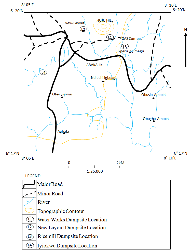
 | Figure 2. Pictorial view of (L4) Iyiokwu dumpsite |
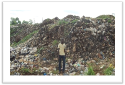
 | Figure 3. Pictorial view of (L3) Rice mill dumpsite |
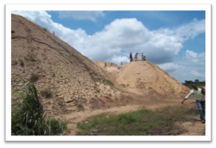
 | Figure 4. Pictorial view of (L2) New layout dumpsite |
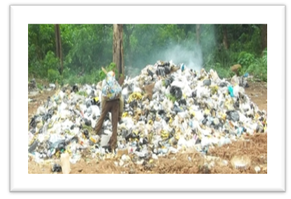 | Figure 5. Pictorial view of (L1) Water works dumpsite |
1.2. Physiology/ Climate
- Abakaliki urban is generally characterized by a low level land with a few isolated residual hills due to igneous activity in the area which left some deposits of volcanic rocks. The highest elevation in the study area is represented by the conically shaped popular Juju hill, which is about 300 m above sea level. The predominant shale lithology has favored the low erodibility of the lithology, resulting in absence or near absence of deep cut valleys and erosion channels (Aghamelu et al., 2011). The major river that drains the area is the Ebonyi River and its tributaries; Iyiudene and Iyiokwu streams. Both tributaries are perennial and usually overflow their banks at the peak of the rains. This area is characterized by two climatic seasons; the wet and dry seasons, also known as the rainy and harmattan seasons. The rainy or wet season starts in late April and last till October with heavy rainfalls recorded in the months of June, July and September. There is usually decline of rainfall in August. This is usually referred to as “August break”. The rainy season is usually a period of high humidity, generally low temperatures and low evapotranspiration. The main soil types found in Abakaliki area are silty hydromorphic soil. This soil has moderate to reddish-brown silty-clay subsoil. It has moderate to low drainage properties with a fairly high natural fertility rate. It provides good crop yields of vegetables and tubers. This accounts for the major occupation of the people, which is farming. The vegetation of the area is mostly characterized by tree shrubs and a variety of other trees such as palm trees. Most of the vegetations are ever-green while some are deciduous.
1.3. Geology
- The Abakaliki area falls within the Southern Benue Trough. Burke et al. (1972) gave evidences to support the fact that the origin of the Benue Trough was closely associated with the breakup of western Gondwanaland during the separation of the African and South American Plates, and opening of the South Atlantic Ocean, in the early Cretaceous. Murat (1972) pointed out that the first marine transgression of the Benue Trough started around the middle Albian period, with the deposition of the Asu River Group (Abakaliki Shale Formation and other undifferentiated sediments) in the Southern Benue Trough. The Asu River Group sediments are predominantly shales and localized development of sandstone, siltstone and limestone facies as well as extrusives and intrusives (Reyment, 1965). The group has an average thickness of about 2000 m and uncomfortably overlies the Precambrian Basement (Benkhelil et al., 1989). The Santonian tectonic phase is resulted in series of folding and fracturing of these rocks, giving rise to chains of anticlines known as the “Abakaliki Anticlinorium” (Reyment, 1965). The major fracture system which houses the lead-zinc minerals are in NW and NNW SE and SSE (Farrington, 1952). The Asu River Group sediments in the Abakaliki area have been further divided into Abakaliki and Ebonyi formations (Agumanu, 1989). The Abakaliki Formation is predominantly dark grey colored shale, (weathers to brownish material in the greater part of the formation), blocky, and indurated in most locations, yet fissile in some locations.
2. Materials and Methods
2.1. Soil Sampling
- A profile of 60 cm was made on the sites, disturbed soil samples within 0 – 30 cm along the profile were collected by scraping. The samples were then bagged and labeled. A core sampler was fully inserted into the soil so that the upper part of the cylinder was completely filled with soil. The core sampler was extracted from the soil, filled with soil sample. Both ends of the core sampler were cut to ensure that the volume of soil in it is equivalent to the volume of the core. The core sampler with the soil was firmly tied in a sample bag and labeled. The soil samples were kept in polythene bags for further analysis at the soil laboratory, faculty of Agricultural Sciences, Ebonyi State University Abakaliki.
2.2. Determination of Soil Texture
- The procedure commonly used involved determining particle sizes by the rates at which they drop out of solution. While a set of sieves was used to separate out the sand fraction, a sedimentation procedure was then used to determine the amounts of silt and clay according to IITA (1999).
2.3. Hydraulic Conductivity
- In saturated soils, the hydraulic conductivity is represented as Ksat and in unsaturated soils; the hydraulic conductivity is represented as K. The quantity of water per unit of time (Q) that flows through a column of saturated soil can be expressed by Darcy's Law, as follows:
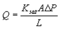 Where Ksat is the saturated hydraulic conductivity, A is the cross-sectional area of the column through which the water flows, ∆P is the hydrostatic pressure difference from the top of the column to the bottom of the column, and L is the length of the column. Since area A and length L of a given column are fixed, the rate of flow is determined by the hydraulic force DP driving the water through the soil (commonly gravity) and the saturated hydraulic conductivity, Ksat.
2.4. Determination of Bulk Density, Porosity, and Moisture Content
- The three parameters were determined as shown below.
2.4.1. Weigh and Record Sample
- Weigh and enter the weight of the soil sample on the Soil Data worksheet. Weigh an empty plastic bag to account for the weight of the bag. Mix sample thoroughly in the bag by kneading it with your fingers. Take a 1/8-cup level scoop subsample of loose soil (not packed down) from the plastic bag and place it in a paper cup (a glass or ceramic cup may be used). Weigh the soil subsample in its paper cup. Enter the weight on the Soil Data worksheet. Weigh an empty paper cup to account for its weight. Enter the weight on the Soil Data worksheet.
2.4.2. Dry Subsample
- Place the paper cup containing the subsample in a microwave and dry for a minimum of two minute cycles at full power. Open the microwave door for one minute between cycles to allow venting. Weigh the dry subsample in its paper cup and enter the weight on the Soil Data worksheet.
2.4.3. Calculation of Bulk Density
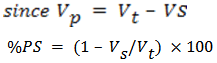
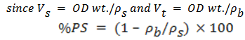
- ρb = oven-dry wt./total volume of the soil = OD wt./VtWhere Vt is the total volume of the soils and is the sum of the volume of the pore space (Vp) and (Vs) solid space (Vt = Vs + Vp).
2.4.4. Calculation of Porosity
- The percent pore space of a soil can be calculated with the following relations.
 | (1) |
 | (2) |
 | (3) |
 | (4) |
2.4.5. Calculation of Moisture Content
- The percentage moisture content of soil can be related with the following relations;
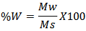 Where Mw =mass of water= oven-dry wt─ air dry wt and Ms = mass of soil = oven-dry wt
 3. Results and Discussion
3.1. Water Works Dumpsite
- The water works dumpsite has a porosity of 53.3% which could be considered high (Table 1). The conductivity of 63.2 cm/hr is also high. By implication, it means that by the end of a day infiltrate (leachate) would have migrated about 15.2 m. (if and only if the same soil medium continues). In the aspect of texture, the soil at Water Works dumpsite has 54% of sand, 30.7% of clay and silt 15.3%. The high content of clay (30.7%) will be able to compensate for the 54% sand, reducing its permeability. Remember, as sand becomes increasinglyclayey, fluids in the intergranular pore paces are displaced by clay and the bulk density increases and infiltration reduces. The mean bulk density of 1.24 pictures very clear that the soil is sandy loan or rather more of loamy, bulk density for sand and sandy soils ranges from 1.3 to 1.8. Thus 1.24 is relatively high for a sandy loam soil. Therefore, with 30.7% clay and 15% silt, and a bulk density of 1.24 (relatively high for a sandy loam) one can say that infiltration of the leachate will be minimal.
|
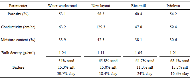
3.2. New Layout Dumpsite
- The Porosity of the New Layout is 58.3%, which is high and will promote infiltration. The hydraulic conductivity of 125.3 cm/hr is very high. This implies that in a day, the leachate would have migrated about 30m. This result is very-very alarming considering the fact this depth is the average depth to aquifer within the Abakaliki formation. The soil texture indicates 65.8% of sand (high), 15.77% and 18.39% of silt and clay respectively which is not much to compensate for the sand, making the soil sandier. But the bulk density is 1.11g/cm3, this is lower than a sandy soil of which class it falls under. Suffice to say that infiltration of leachate will be high in this dumpsite. This is evident in the hydraulic conductivity test which shows 125.3 cm/hr (30.1 m/day) for new layout soil. This can be interpreted to mean that every leachate generated within the Dumpsite, hits the aquifer same day (if and only if the same soil medium continues).
3.3. Rice Mill Dumpsite
- Porosity of 60.4 is very high and will readily promote infiltration, the hydraulic conductivity of 47.8 cm/hr implies a migration rate of 11.5 m/day. This value is high and posses a treat to the aquifer. With 38.1% moisture content, the soil here still has an affinity for fluid (leachate) infiltration to the tune of about 61.9%. This high affinity for moisture will invariably encourage infiltration. The texture indicates 64.7% sand (very high). But with up to 24% clay content and 11.3% silt, the permeability can be moderately checked. However, the hydraulic conductivity of 47.8 cm/hr (11.5 m/day), low moisture content, high porosity and low bulk density the soil will readily promote infiltration.
3.4. Iyiokwu Dumpsite
- Porosity of 54.2% is on the high side and this is liable to infiltration. With 30.6% moisture content, this implies that the soil will readily allow infiltration to the tune of 69.4%. Hydraulic conductivity of 59.4 cm/hr implies that the leachate will migrate about 14.3 m within a day; this is a very high value. Clay of 16.32% and silt of 15.32% might not be enough to compensate for 68.36% of sand content. But the bulk density of 1.21 shows a slightly higher density, thus a reduced permeability. Integrating the other parameters, infiltration can be said to be moderate in this site.
4. Conclusions
- Summary of the results from the four Dumpsites show that they all have high porosity, high hydraulic conductivity, high affinity for moisture due to their general low moisture content, hence are all susceptible to infiltration. However, the higher clay content and higher Bulk density of the Water Works dumpsite will cause the site to have minimal infiltration rate. While high hydraulic conductivity of the New Layout site makes it more prone to infiltration. Consequently, while the Water works and Iyiokwu dumpsites could be retained at the present locations, the Rice mill and New layout dumpsites should be relocated to safer sites.