Geosciences

p-ISSN: 2163-1697    e-ISSN: 2163-1719

2019;  9(1): 18-26

doi:10.5923/j.geo.20190901.03


Paleoenvironmental Reconstruction of an Onshore Field, Coastal Swamp Depobelt, Niger Delta

Okoli Emeka Austin1, Acra Jones Edward2, Ehirim Chukwuemeka Ngozi3, Adewale Dosunmu, Okechukwu Ebuka Agbasi3

1Federal University of Technology, Owerri, Nigeria

2University of Port Harcourt, Nigeria

3Micheal Okpara University of Agriculture, Umudike, Nigeria

Correspondence to: Okechukwu Ebuka Agbasi, Micheal Okpara University of Agriculture, Umudike, Nigeria.

Email:

Copyright © 2019 The Author(s). Published by Scientific & Academic Publishing.

This work is licensed under the Creative Commons Attribution International License (CC BY).
http://creativecommons.org/licenses/by/4.0/

Abstract

Three (3) wells from “Sigma Field” and biostratigraphic data of Sigma-25, coastal Swamp Depobelt, Niger Delta were integrated to carry out a sequence stratigraphic analysis of depositional systems in the field and further develop conceptual models in areas not penetrated by wells. The analysis revealed one (1) 3rd order Maximum Flooding Surfaces (MFS) dated 11.5 Ma MFS delineated. The 11.5Ma MFS was identified from bio-stratigraphic analysis of micro-floral and palynological zonation provided for Sigma-25 which dated sediments that penetrated the F9500 zone and P784-750 zone of the Serravallian in the Middle Miocene age on the Niger Delta chronostratigraphic chart. Other candidate Maximum Flooding surfaces dated 10.4 Ma MFS and 9.5 Ma MFS respectively were identified on Sigma-25 using lowest resistivity value and widest separation between density and neutron logs. Four 3rd order depositional sequences bounded by four erosional surfaces interpreted as Sequence Boundaries and dated 12.1, 10.6, 10.35, and 8.5Ma were also delineated. A Transgressive Surface of Erosion (TSE) that mark the onset of marine flooding and turnarounds from progradational facies to retrogradational facies during sequence build-up was delineated in the fourth depositional sequence. The delineated sequences comprised Lowstand Systems Tracts, Transgressive Systems Tracts and High stand Systems Tracts and predominantly reflected a regressive phase. The Low stand Systems Tract (LST) is representative of a delta front process specifically the Distributary Channel fill sediments. Transgressive Systems Tract (TST) consists of retrogradational marine shales deposited during high relative sea levels and when accommodation space was higher than rate of sediment influx. High stand Systems Tracts (HST) consisted of Distributary Mouth bars sands in the first and second depositional sequence displaying generally an aggradational stacking pattern and Fluvial sands in third and fourth depositional sequence displaying generally an aggradational stacking pattern. The depositional model in the field was inferred from Conceptual models generated with the available wells in both strike and dip direction. Sigma field showed a transition from a deltaic environment to a fluvial environment as sea level generally shows a relative fall going upwards across the well section. The sands of LST and HST show good reservoir qualities while the shales of the TSTs could form potential reservoir seals and show source rock potential. The above recognized sequences were deposited within the Non-marine – Inner Neritic paleo-water depths.

Keywords: Unconformities, Progradation, Retrogradational, Aggradational, Paleoenvironments and Reservoir

Cite this paper: Okoli Emeka Austin, Acra Jones Edward, Ehirim Chukwuemeka Ngozi, Adewale Dosunmu, Okechukwu Ebuka Agbasi, Paleoenvironmental Reconstruction of an Onshore Field, Coastal Swamp Depobelt, Niger Delta, Geosciences, Vol. 9 No. 1, 2019, pp. 18-26. doi: 10.5923/j.geo.20190901.03.

1. Introduction

Sequence stratigraphic analysis of these successions define key stratal surfaces at abrupt dislocations of system tracts to delineate broad-scale facies trends formed by along-basin shifts in depositional environments and changes in preservation within system tracts (Vail et al., 1977; Posamentier et al., 1988; Postma, 1995). Higher-frequency progradation and transgression of deltaic systems tracts has been related to both random autocyclic channel avulsion and associated delta lobe switching, and to allocyclic processes like sea-level fluctuations and climate changes (Thorne and Swift, 1991). The internal architecture of deltaic successions that prograde onto mobile shale substrates can be significantly complicated by structural collapse of the delta front. Despite extensive literature on large delta deposits, little attention has been focused on influence of mobile substrates on the resulting sequence stratigraphy.
The Niger Delta has a distinctive structural and stratigraphic zonation. Regional and counter-regional growth faults, developed in an outer-shelf and upper-slope setting, are linked via a translational zone containing shale diapirs to a contractional zone defined by a fold-thrust belt developed in a toe-of-slope setting (Hooper, 2002). Damuth (1994) considered Neogene gravity tectonics and depositional processes on the modern deep Niger Delta continental margin. He recognized three regional structural styles; (1) an upper extensional zone of listric growth faults beneath the outer shelf, (2) a translational zone of diapirs and shale ridges beneath the upper slope; and (3) a lower compressional zone of imbricate thrust structures (toe thrusts) beneath the lower slope and rise. He suggested these areas with different structural style are linked together on a regional scale and that these variations in style suggest that large portions of this thick sediment prism are slowly moving downslope by gravity collapse. Cohen and Ken McClay (1994) discussed sedimentation and shale tectonics of the northwestern Niger Delta front. Morgan (2004) examined relationships between mobile shale structure and channel formation above the compressional toe of Niger Delta and highlighted the importance of transfer zones within the toe thrust belt as a control on the underlying structural framework. Adeogba et al. (2005) discussed transient fan architecture and depositional controls from near-surface 3-D seismic data of Niger Delta continental slope. Corredor et al. (2005) related structural styles in the deep-water fold and thrust belts of the Niger Delta and concluded that there are two complex, imbricate fold and thrust belt systems (the inner and outer fold and thrust belts) that are the product of contraction caused by gravity-driven extension on the shelf. Okoli et al., (2018a) explained the role of deformation in controlling depositional patterns in the south-central Niger Delta, their work was however focused mainly at the compressional toe of the delta, and they concluded that structural elements are the primary control of accommodation changes on the slope and toe of the delta.
Other examples of deltaic systems that rapidly prograded onto mobile substrates include: the Baram delta, offshore Brunei (Rensbergen et al., 1999), Caspian Sea (Khalivov and Kerimov 1983), and Alboran Sea (Morley 1992). Daily (1976) synthesized relationships between progradation, subsidence, basal under compacted shale wedge, growth faulting, shale diapirism and overthrusting within the Mississippi, Niger and Mackenzie Delta systems. They established that shale diapirs and associated growth faults exerted an important influence on large- and small-scale bedding geometries and facies changes of syntectonic shallow- marine, shoreface and tidal strata for the area. Edwards (2000) reviewed the origin and significance of failed shelf margins of Tertiary northern Gulf of Mexico basin and recognized the role of slumping in forming unconformities of regional extent along retrograde failed shelf margins. Rensbergen and Morley (2000) discussed a 3D Seismic study of a shale expulsion syncline at the base of the Champion delta, offshore Brunei and its implications for the early structural evolution of large delta systems.
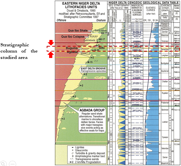
Figure 1. Niger Delta Sequence Stratigraphic Column

2. Materials and Methods

Materials provided for this study include seismic volume in SEG-Y format, geophysical well logs, base map and check shot data from Sigma field. The standard micropaleontological sample preparation method involving sample disaggregation and washing through a 63-micron mesh sieve, drying and picking of the foraminifera and accessory fauna were used (Armstrong and Brasier, 2005; Ukpong et al, 2017). The foraminiferal statistical data was imputed into Strata- Bugs (Biostratigraphy Data Management software) for data processing and integration with the well logs data. Seismic analysis was achieved on Petrel window (version 2016). The workflow plan is shown in figure 2.
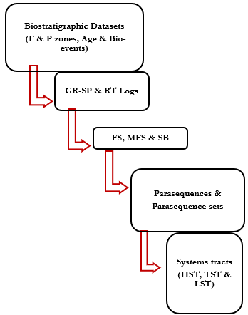
Figure 2. Sequence stratigraphic analysis Workflow
The Maximum Flooding Surfaces (MFSs) were identified as shaliest part of the section. It represents the points with the highest gamma ray values.
The Transgressive Surface (TS) is a prominent flooding surface. It represents the first major flooding surface to follow the sequence boundary and is usually identified on the gamma ray log by fining upward. This is an indication of the beginning of rise in relative sea level at an increasing rate.
Depositional sequence was determined by the cycle of sea level changed. In vertical succession, depositional sequences were identified in the well logs by using the order.
The environment of deposition was identified using gamma ray log responses. A funnel log response (progradational) represents a change from mainly shale into high sand lithology. It also indicates a gradual change from clastic to carbonate deposition. A bell log response is an indication of lithology change from sand to shale (waning of submarine fans-reducing sand contents). It is predominant within meandering or tidal channel deposits in a non-marine setting. A cylindrical response indicates fluvial channel sands, turbidites and aeolian sands.

3. Results and Discussion

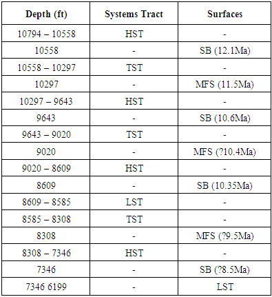
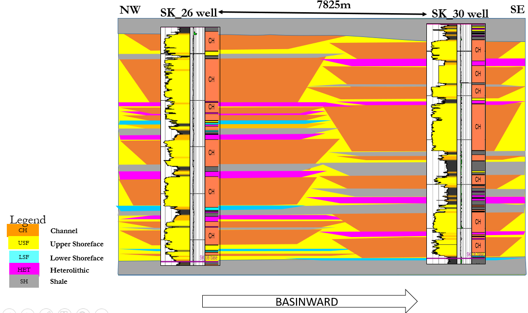
The following methods were adopted for the sequence stratigraphic interpretation:
Foraminiferal biozonation and Paleo-bathymetric interpretation, Paleo-bathymetric interpretation shows that the environment ranged from non-marine through shallow inner neritic, inner neritic, middle neritic and outer neritic (Figure 1).
Geophysical well log interpretation (gamma-ray and resistivity logs) was confirmed from the lithologic information. Lithostratigraphic analyses were based on detailed description gamma ray log signatures, which the result shows an alternation of sand and shale in a progressive pattern. The well log characteristics were used to delineate the different systems tracts (Figure 3). Sequence boundaries were delineated at points of inflection from progradation to retrogradation of parasequences in shallowing upward sand sections, and at the fluctuation points of lowstand systems tract. Points of high gamma ray and lowest resistivity log response were used for the identification of maximum flooding surfaces (Onyekuru et al., 2012).
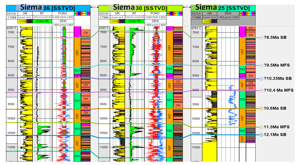
Figure 3. Geophysical well log interpretation
From the foraminiferal abundance/diversity curves and well log signatures, three Maximum Flooding Surfaces (MFS) were identified at 8308ft, 9020ft and 10297ft and dated 9.5Ma, 10.4Ma and 11.5Ma respectively and Sequence boundaries (SBs) at 7346ft, 8609ft, 9843ft and 10558ft dated 8.5Ma, 10.35Ma, 10.6Ma and 12.1Ma respectively. Lowstand Systems Tract (LST), Transgressive Systems Tract (TST) and Highstand Systems Tract (HST) were also identified as shown in table 1.
Table 1. Sequence stratigraphic summary of Sigma Field
     
The MFSs and SBs identified from Sigma-25 foraminiferal sequence Stratigraphic analysis were correlated across Sigma-30 and Sigma-26. The correlation was base on identifying the MFSs on Sigma-30 and Sigma-26 individually. The MFSs were identified by looking out for shale tops of high acoustic properties within a shale interval that corresponds to the lowest resistivity value and widest separation between neutron and density values (Okoli et al., 2018b).
The maximum flooding surface (MFS) and sequence boundaries (SB) are the key bounding surfaces identified in the well with their corresponding depths. The ages and bio-events were obtained based on the zonal correlations and cycles of Blow (1969, 1979) and by correlation with the Niger Delta Chronostratigraphic Chart (Fig. 1).
Systems tracts are components of depositional sequences. They are divided into three groups according to relative sea level at the time of deposition: Lowstand at relatively low sea level, Transgressive as shoreline moves landward (retrogradation) and Highstand at relatively high sea level. The shape and content as well as the stratigraphic order of systems tract can be predicted.
The Lowstand Systems Tract (LST) deposits are derivatives of gravity movement due to sediments depositions by rivers as they traverse the shelf and upper slope proceeding towards the incised valleys and canyon along the continental slope (Armstrong and Braisier 2005). The Lowstand Systems Tract is characterized by interbedding of shale and sandstone that follow a coarsening upward pattern with initial progradational stacking pattern and a subsequent aggradational stacking pattern. There is shallowing upward trend of foraminiferal assemblages from regions with high foraminiferal abundance to complete barren regions. Transgressive Systems Tract (TST) identified showed an upward increase in foraminiferal abundance and diversity, it represents the well sections with the highest foraminiferal abundance and diversity often culminating in the Maximum Flooding Surfaces. The TSTs identified exhibits retrogradational geometries. These deposits are composed of sand units characterized by fining and thinning upward trends which are overlain by the Maximum Flooding Surfaces and underlain by Sequence Boundaries and Transgressive Surfaces (TS). The TST contains rich preserved microfossils. This has been reported to be due to the progressive supply of sediments in the process of transgression as turbidity current reduces leading to the high occurrences of clear water micro-fauna (Armstrong and Braisier 2005).
Highstand Systems Tract (HST) are deposits that accumulates when sediment supply exceeds the rate of accommodation space at the onset of relative sea-level rise (Catuneanu et al. 2011). The HST deposits are capped by surfaces of erosion or non-deposition and their correlative conformity (Posamentier and Allen 1999). The HSTs delineated were characterized by progradational sequences with an alternation of sands and shale, occurrences of sparse benthonic foraminifera and complete absence of the planktic assemblages. The pro-grading HSTs consists of gravity flow deposits with high rate of microfossils reworking with shallowing upward trend of benthic fauna (Armstrong and Braisier 2005).
Between depth 10600-11150 in Sigma-26 and 10700-11350 in Sigma-30, our first HST was identified which depicted an aggradational stacking pattern which signifies rapid deposition of continental sediments outpacing the sea level fall. At 10650 in Sigma-30 and 10600 in Sigma-36, sea level just begins to rise while deposition from continent continues leading to a retrogradational stacking pattern in our first of a TST which culminates to 11.5 Ma MFS in the first depositional sequence of our well section in the Sigma field.
Deposition from continent continues rapidly going upwards in our well section leading to massive sand intervals observed with thing shale interclast. At 9650 in Sigma-26 and 9650 in Sigma-30, a sequence boundary is identified (10.6Ma SB). This marks the onset of another transgressive episode which is clearly seen in Sigma-25 with thick shale intervals and barely seen in Sigma-26 and Sigma-30 where deposition must have been continuous. From this observation, it is clear that Sigma-26 and 30 are located at our river mouth while 25 would represent our overbank deposits, all these environments in a delta front process.
The LST interval was observed just after the last episode of transgression. This represented continental deposition in accommodation space and characterized with interclast of fine marine sediments within its depositional architecture. After that short episode of static sea level at 8450 in Sigma-30 and 26, transgression occurs which peaked at 9.5Ma LFS at 8150ft in Sigma-30 and 8200ft in Sigma-26. Going upwards from that point we see stacking pattern representing deposition in a fluvial environment across the well section which represents the HST interval in the fourth depositional sequence terminating with an 8.5Ma SB. The entire well section from the bottom to the top depicts a general sea level fall from a deltaic environment to a fluvial environment.
Conceptual Models: Figure 5 shows deposition from the bottom of the well section 11.5Ma MFS. This is a conceptual model showing depositional pattern away from both wells (Sigma-26 and 30) aligned in the strike direction. The depositional pattern is shown along the strike direction. The stacked sequence of the reservoir shows delta front and channel incisions. The reservoirs were deposited as channels and shoreface sands in wave dominated high energy deltaic setting as shown in Figure 6. The evidence of marine influence in the depositional model is seen from the thick shale interval in the Sigma-30 well. Figure 7 shows the high energy deltaic environment between wells 30 and 25 in the dip direction with a fault cutting across both wells. We observe thicker shales in Sigma-25 which is more basin ward. This occurring in the second depositional sequence of our well section. Figure 9 and 10 shows deposition in a strike direction in the second depositional sequence between Sigma-26 and 30. We see more fluvial input in the deltaic environment characterizing delta front processes. In our third depositional sequence shown in Figure 11 and 12 we see predominance of the fluvial sediments characterized of clean channel sands over the heterolithic sediment of the environments.
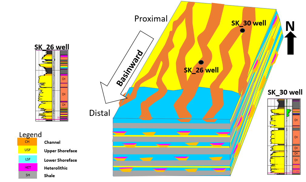
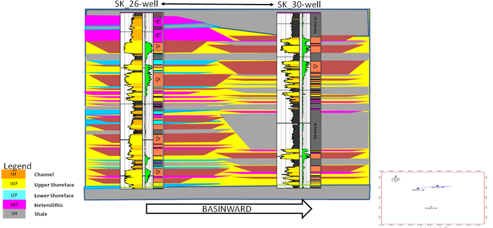
Figure 5. Conceptual depositional environment model of Sigma-26 and 30 in strike direction as at 11.5 Ma MFS
Figure 6. Conceptual depositional environment model as at 11.5 Ma MFS
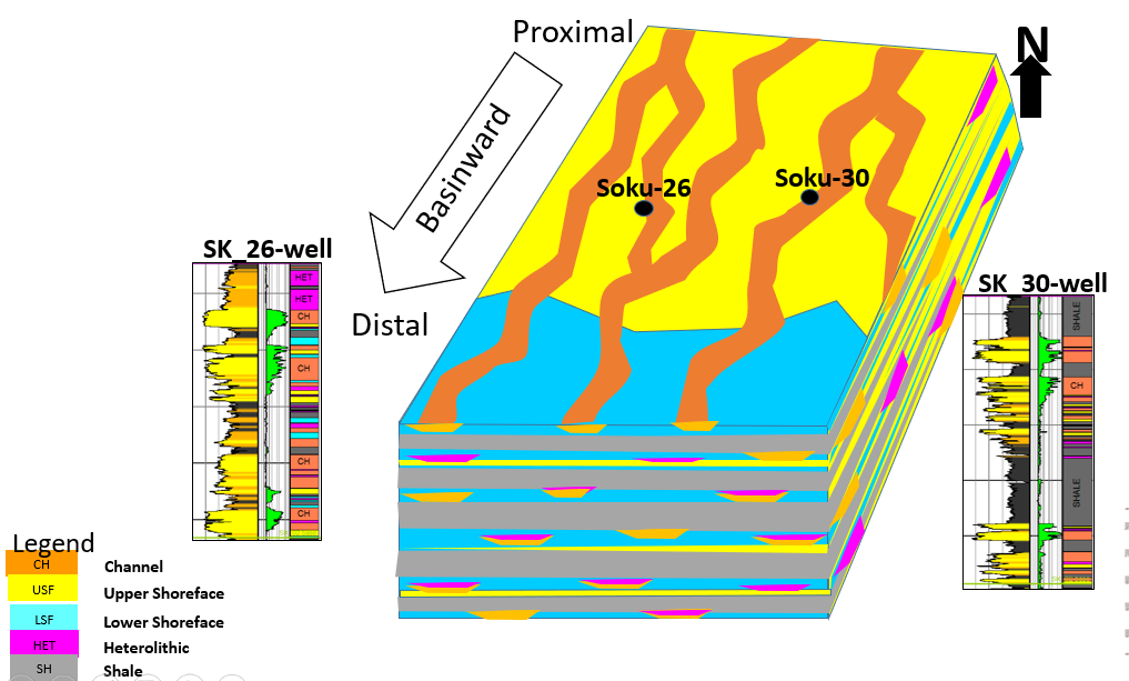
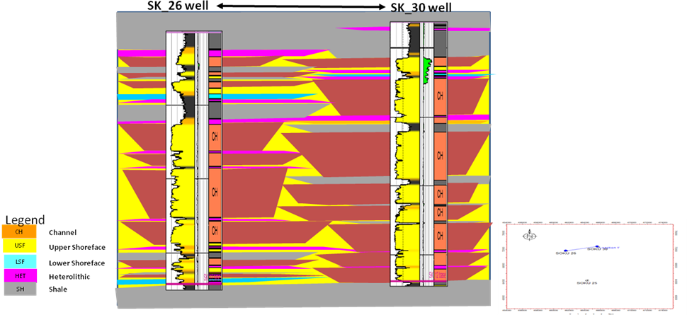
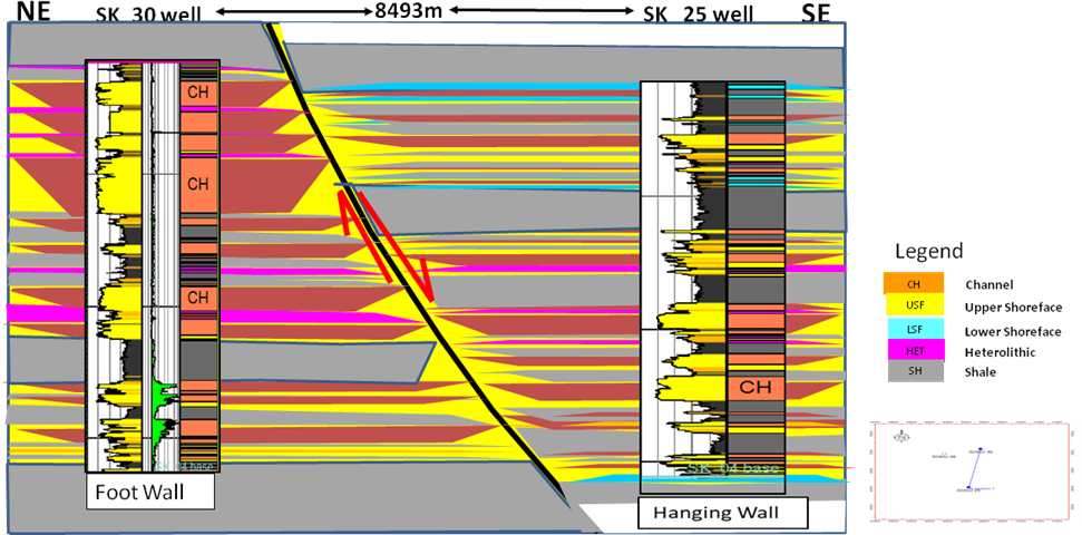
Figure 7. Conceptual depositional environment model of Sigma-25 and 30 in dip direction as at 10.4 Ma MFS
Figure 8. Conceptual depositional environment model in dip direction as at 10.4 Ma MFS
Figure 9. Conceptual depositional environment model as at 10.4 Ma MFS
Figure 10. Conceptual depositional environment model as at 10.4 Ma MFS
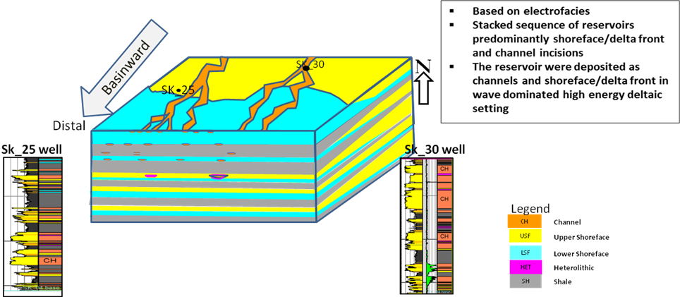
Figure 11. Conceptual depositional environment model as at 9.5 Ma MFS
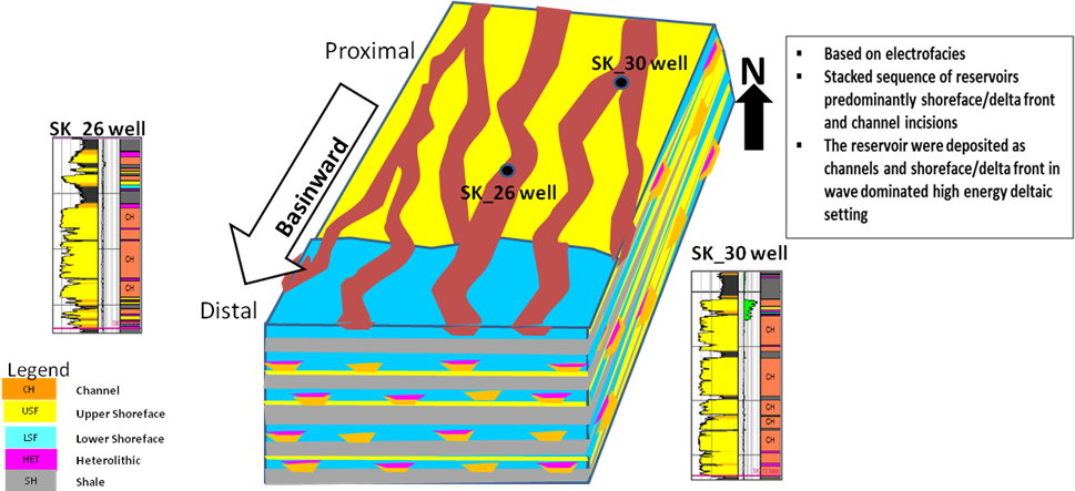
Figure 12. Conceptual depositional environment model as at 9.5 Ma MFS
An observation of the shape and contents as well as stratigraphic distribution of the identified systems tracts in Sigma field shows they could have good reservoir potentials suitable for exploration. The Lowstand systems tracts (LSTs) identified contains thick sand units which are bounded by shales which could act as sealing rocks. The sands could act as good reservoirs while active growth faults seen in the vicinity of the well could serve as pathways for hydrocarbon upward migration. The shale unit in the overlying Transgressive Systems Tract and the underlying High stand Systems Tract could form excellent seals assuming the right prevailing conditions. Olusola and Olusola (2014) identified hydrocarbon occurrences within Low stand Systems Tracts and Transgressive Systems Tracts reservoirs where the major traps are structural and shales within the Transgressive Systems Tract. Sands of reservoir quality are also found within the Transgressive Systems Tracts, especially those occurring within the non-marine to shallow inner neritic environment (Mitchum et al, 1993). The transgressive sands constitute good potential reservoirs. These sands are capped by the overlying and underlying shales of the High stand Systems Tracts and Low stand Systems Tract which provided good stratigraphic traps. The hemipelagic - pelagic shales found in the Transgressive Systems Tract, and the levees of the leveed channel of slope fans are possible excellent source rock in the well field. Also, the High stand Systems Tracts with identified thick sandy unit can serve as important reservoirs as they are also capped by pelagic shales within the systems tract.

4. Conclusions

One MFS which is the 11.5Ma MFS was discovered from bio-stratigraphic analysis which corresponded to Cassidulina 7 shale marker and two other candidate MFSs which are the 10.4 and 9.5 Ma were inferred from use of well logs in identifying MFS. Four depositional sequences were identified with the first and second depositional sequence culminating into 12.1Ma SB and 10.6Ma SB respectively. As we go upwards from the bottom of the well, the stacking pattern depicts delta front depositional environment as shown in our conceptual model interpretations. The third and fourth depositional sequence terminating at 10.35 Ma SB and 8.5Ma SB respectively characterized high energy fluvial environment as we see from the clean sands deposited within the interval. The sands within the depositional sequence show good reservoirs properties and the thick shales within the fourth and depositional sequence have source rock potentials.

References

[1]  Armstrong, H. and Brasier, M. (2005). Microfossils. (2nd ed). Blackwell Publishing Malden, USA. 274-275.
[2]  Adeogba, A.A., T.R. McHargue, and S.A. Graham, (2005). Transient fan architecture and depositional controls from near-surface 3-D seismic data, Niger Delta continental slope: American Association of Petroleum Geologists Bulletin, v. 89, p. 627-638.
[3]  Blow, W.H. (1979). The Cainozoic Globigerinida. Leiden, E.J. Brill, 1400-1413.
[4]  Blow, W. H. (1969). Late Middle Eocene to Recent Planktonic Foraminiferal Biostratigraphy,” Proc. First International Conf. Planktonic Microfossils. 199 – 422.
[5]  Corredor, F., Shaw, J. H. and Bilotti, F. (2005). Structural styles in the deep-water fold and thrust belts of the Niger Delta. AAPG Bulletin. (89) 6: 753–780.
[6]  Cohen, H.A., and McClay K., (1996). Sedimentation and shale tectonics of the northwestern Niger Delta Niger Delta front: Marine and Petroleum Geology, v. 13, p. 313–328.
[7]  Catuneanu, O., Galloway, W.E., Kendall, C.G., Miall, A.D., Posamentier, H. W., Strasser, A. and Tucker, M.E. (2011). Sequence Stratigraphy: Methodology and Nomenclature. Newsletters on Stratigraphy. 44 (3): 173–245.
[8]  Damuth, J.E., (1994). Neogene gravity tectonics and depositional processes on the deep Niger Delta continental margin: Marine and Petroleum Geology, v. 11, p.320-346.
[9]  Daily, G.C., (1976). A possible mechanism relating progradation, growth faulting, clay diapirism and overthrusting in a regressive sequence of sediments: Bulletin of Canadian Petroleum Geology, v. 24; p. 92-116.
[10]  Edwards, M. B., (2000). Origin and significance of retrograde failed shelf margins; Tertiary Northern Gulf Coast Basin: Transactions of the Gulf Coast Association, v. 50, p. 81-93.
[11]  Hooper, R.J., Fitzsimmons, R.J Grant, N. and Vendeville, B.C. (2002). The role of deformation in controlling depositional patterns in the South-Central Niger Delta, West Africa: Journal of Structural Geology, v. 24, p. 847-859.
[12]  Khalivov, N.Y., and Kerimov, A.A. (1983). Origin of mud volcanism and diapirism: International Geological Review, v. 25, p. 877-881.
[13]  Morley, C.K., (1992). Notes on Neogene basin history of the Western Alboran Sea and its implications for the tectonic evolution of the Rif-Betic Orogenic Belt: Journal of African Earth Sciences, v. 14, p. 57-65.
[14]  Morley, C.K., Crevello, P. and Ahmad, Z.H. (1998). Shale tectonics and deformation associated with active diapirism: The Jerudong Anticline, Brunei Darussalam: Journal of the Geological Society of London, v. 155, p. 475–490.
[15]  Mitchum, R. M. Jr., Sangree, J. B., Vail, P. R. and Wornardt, W. W. (1993). Recognizing Sequences and Systems Tracts from well logs, seismic data and biostratigraphy: Examples from the Late Cenozoic of the Gulf of Mexico. In Eds.
[16]  Weimer, P. and Posamentier, H. W. (2000). Siliciclastic sequence stratigraphy: Recent developments and applications. AAPG Memoir 58, 163 – 165.
[17]  Morgan, R., (2004). Structural controls on the positioning of submarine channels on the lower slopes of the Niger Delta: Geological Society, London, Memoir 29, p.45-51.
[18]  Onyekuru, S.O., Ibelegbu, E.C., Iwuagwu, J.C., Essien, A. G and Akaolisa, C.Z. (2012). Sequence Stratigraphic Analysis of “XB Field”, Central Swamp Depobelt, Niger Delta Basin, Southern Nigeria. International Journal of Geosciences. 3: 237-257.
[19]  Okoli E.A., Okechukwu E.A. Casmir, A and Inyang N.J.. (2018a). Seismic Analysis of the Transgressive Systems Tracts (TSTS) of the Niger Delta. Earth Science Malaysia. 2(2). 16 – 19. Doi.org/10.26480/esmy.022018.16.19.
[20]  Okoli E.A., Onyekuru S.I, Okechukwu E.A and Zaidoon T.A. (2018b). Application of Model-Based Inversion Technique in a Field in the Coastal Swamp Depobelt, Niger Delta. International Journal of Advanced Geosciences, 6 (1). 122 – 126. doi: 10.14419/ijag.v5i2.7890.
[21]  Olusola, A. O. and Olusola, J. O. (2014). Sequence Stratigraphic Analysis of Olay Field, Niger Delta, and Implications for Hydrocarbon Prospect. The Pacific Journal of Science and Technology 15(1): 375-392.
[22]  Posamentier, H. and Allen, G. (1999). Siliciclastic sequence stratigraphy: concepts and applications. Society of Economic Paleontologists and Mineralogists, Concepts in Sedimentology and Paleontology 7.
[23]  Posamentier, H.W. and Vail, P.R. (1988). Eustatic control on clastic deposition II-sequence and systems tractsmodels. In: Wilgus, C.K., Hastings, B.S., Kendall, C.G.St.C., Posamentier, H.W., Ross, C.A., and VanWagoner, J.C. (eds.), Sea level changes: an integrated approach: SEPM Special Publication 42: 125-154.
[24]  Postma, G., (1995). Sea-level related architecture trends in coarse grained delta complexes, in S.K. Chough and G.J. Orton, eds., Fan Deltas: Depositional Styles and Controls: Sedimentary Geology, v. 98, p. 3-12.
[25]  Rensbergen, P.V., Morley, C.K, Ang, D.W., Hoan, T.Q. and Lam, N.T. (1999). Structural evolution of shale diapirs from reactive rise to mud volcanism: 3D seismic data from the Baram delta, offshore Brunei Darussalam: Journal of The Geological Society, v.156, p. 633-650.
[26]  Rensbergen, P.V., and Morley, C.K. (2000). 3D Seismic study of a shale expulsion syncline at the base of the Champion delta, offshore Brunei and its implications for the early structural evolution of large delta systems: Marine and Petroleum Geology, v. 17, p. 861–872.
[27]  Sangree, J. B., Vail, P. R. and Mitchum, R. M. Jr. (1990). A summary of exploration application of sequence stratigraphy. GCSSEPM Foundation, 11th Annual Research Conference Program and Abstracts, 321 – 327.
[28]  Thorne, J.A., and Swift, D.R (1991). Sedimentation on continental margins VI: A regime model for depositional sequences, their component systems tracts, and bounding surfaces, in D.J.R, Swift, G.E. Oertel, R.W. Tillman, J.A. Thorne, eds., Shelf Sand and Sandstones Bodies: Geometry, Facies and Sequence Stratigraphy: Special Publication International Association of Sedimentologists 14, p. 189-255.
[29]  Ukpong, A. J., Ikediasor, K. C., Anyanwu, T. C., Osung, E. W. and Ekhalialu, O. M. (2017). Foraminiferal Biozonation of “Well K-27”, Greater Ughelli Depobelt, Niger Delta Basin, South Eastern Nigeria. EPRA International Journal of Multidisciplinary Research. 3(10):23-32.
[30]  Vail, R.R., Mitchum, R.M. and Thompson, S. (1977). Seismic stratigraphy and global changes of sea level, Part 3. Relative changes of sea level from coastal onlap, in, C.E. Payton, ed., Seismic Stratigraphy - Applications in Hydrocarbon Exploration. American Association of Petroleum Geologists Memoir 26, p. 63-82.