Geosciences

p-ISSN: 2163-1697    e-ISSN: 2163-1719

2018;  8(1): 1-6

doi:10.5923/j.geo.20180801.01


Earthquake Hazard Update in Central Himalaya

Shubham, D. Shanker

Indian Institute of Technology Roorkee, Department of Earthquake Engineering, Roorkee, Uttarakhand, India

Correspondence to: D. Shanker, Indian Institute of Technology Roorkee, Department of Earthquake Engineering, Roorkee, Uttarakhand, India.

Email:

This work is licensed under the Creative Commons Attribution International License (CC BY).
http://creativecommons.org/licenses/by/4.0/

Abstract

To gauge the risk of future earthquakes, one must first understand the earthquake hazard and related earthquake engineering determinations; which usually need estimate of return periods, probabilities of exceedance of specific levels of design load criteria or extremal safety conditions. Himalayan region 29°N - 33°N latitude and 75°E - 81°E longitude which exclusively include Himachal Pradesh and Uttarakhand adjoining have been considered for potential earthquake hazard analyses. This region is one of the most seismically active due to Indian and Eurasian plate collision where large to great earthquakes have occurred in the past. Fifty five years of earthquake data from the year 1963 to 2017 with Mw≥4.0 have been taken from the catalogue of USGS and ISC. The analyses indicate that the earthquake occurrences agree with the Gumbel’s Type I extreme distribution function applied to those maximum magnitude data with novel correlation (0.87). Hazard in the region have been quantified in terms of return periods and probabilities of occurrence of earthquake of any given magnitude. The line of expected extremes (LEE) based on 55 years (1963-2017) of seismicity for the region has been plotted. The medium to large size earthquakes have been predicted. Study indicates that the most probable largest annual earthquakes are close to 4.9 and the most probable earthquake that may occur in an interval of 50 years is estimated to be 7.3.

Keywords: Gumbel’s Type I extreme distribution function, The line of expected extremes (LEE), Return period

Cite this paper: Shubham, D. Shanker, Earthquake Hazard Update in Central Himalaya, Geosciences, Vol. 8 No. 1, 2018, pp. 1-6. doi: 10.5923/j.geo.20180801.01.

1. Introduction

The ultimate goal of seismic hazard assessment and risk evaluation for a particular site or area is to abridge seismo tectonic knowledge and experience used for predicting seismic parameters which in turn can be applied by engineers in design and subsequent earthquake resistant construction. Several investigations support researches on the likelihood of future earthquakes. Several investigations support researches on the likelihood of future earthquakes. It increased public and government awareness regarding seismic activities in Central Himalaya exclusively Himachal Pradesh and Uttarakhand have motivated scientists and researchers in earthquake engineering to deliberate the new theoretical approach to assess the speedy impending hazard with limited data set of the region. Seismic hazard analysis has been an element of good engineering design practice in modern countries for many decades. Assessing the probability of rare and extreme events is an important issue in the risk assessment. Extreme value theory provides the solid fundamentals needed for the statistical modelling of such events and the computation of extreme risk measures. Recently, numerous research studies have analyzed the extreme variations [4-7, 12, 13, 17-19, 21-23, 27, 28]. Thus the use of extreme value now has a lengthy history in several branches of science, including earthquake recurrence estimation. This study estimates the return periods and probability of earthquake occurrences, which would be very helpful for future preparedness planning and even construction practices in the considered area.

2. Regional Tectonic Characteristics

The considered region falls within 29°N - 33°N latitude and 75°E - 81°E longitude and is located in Himalayan range (Fig. 1). This region comes under the Zone IV (severe) and Zone V (very severe) of the seismic zoning map of India (IS: 1893 - 2002) with damage intensity of VIII and IX, respectively. It is seismically a very active region and cascades in the zone of continental collision of the Indian and Eurasian plates [3]. The seismic activity of this area is closely associated with the several active faults running nearby and the dynamic regional tectonic features.
Figure 1. Tectonic map of the considered region. Major and minor faults and other important lineaments are also shown
The region is in the lap of Himalayas, and the Himalayan orogeny resulted in the formation of a large number of major faults in this region. Seismotectonics of the region is related to the regional tectonic features like thrusts and faults, their interactions and clustering of epicentres at places. Thus, the frequent seismic activities observed in this region are due to ruptures at these thrust faults formed by the subduction of the Indian plate below the slow moving Eurasian plate [32]. Some of these prominent faults are the Main Frontal Thrust (MFT) [31], the north-west-south-east trending Main Boundary Thrust (MBT) and Main Central Thrust (MCT) running parallel to Himalayas [1] and other local transverse faults across the area [15]. A highly devastating earthquake of magnitude 7.8 on the Richter scale occurred in 1905 within the study area. Despite the seismicity, the increase in the population in the high seismicity regions of this state has led to increase in the seismic vulnerability.

3. The Data

Study investigates the seismicity data from the year 1963 to 2017 with Mw≥4.0 in the region bounded by 29°N - 33°N latitude and 75°E - 81°E longitude have been taken from the catalogue of USGS and ISC. Prepared seismotectonic map is presented in Fig. 2.
Figure 2. Seismotectonic map of the considered region
In order to study the earthquake risk, probability of occurrence and return periods, the earthquake data distributed over 55 years periods has been divide into one year time interval such as at least one event in each year duration is observed, which is necessary condition of the validity of the approach. In our case, in only few years no events are re-ported, so for the continuity of the data Mw=4 has been assumed for that years.

4. Method of Analysis

Various statistical models have been proposed to the analyses of earthquake occurrence with different degrees of success [6]. The earthquakes occurrence in space and time can be explained through stochastic processes, which are mathematical models of a given physical system change in accordance with the laws of probability [3]. These models have usually incorporated the Poisson distribution, or extended to clustering of events using Markovian models of non-independent events. Estimates thus obtained are often unconvincing because of incompleteness in the data sets or inherent uncertainties in the distributed parameters, which simply ignored. However, the extreme value method has certain clear and obvious advantages as far as the requisite data are concerned when compared with methods requiring the whole data set, which is rarely completely reported. Gumbel’s Type I, which uses extreme value statistics, need only part of the data (the largest earthquakes i.e. extremes).
In the present study, Gumbel’s model based on the extreme value theory is used for the calculations. Although, the details of the theory have been given in [30], some steps are also presented here. The Gumbel distribution is a particular case of Fisher and tippet distribution and is used here for estimation of Gutenberg–Richter parameters, a and b. Gumbel’s [6] extreme value theory postulates that if the earthquake magnitude is unlimited, if the number of earthquakes per year decreases with their increase in size, and if individual events are unrelated, then the largest annual earthquake magnitude is distributed by cumulative distribution function G(m), where
(1)
where α is the average number of earthquakes with magnitude > 0 per year, β is the inverse of the average magnitude of earthquakes under the considered region, and m is the maximum annual earthquake magnitude. The probability integral transformation theorem and manipulation of equation (1) gives the relation:
(2)
where, pm represents the plotting position. The mean frequency of i-th observation in the ordered set of extremes may be represented as
(3)
where, N is the total number of observed data. The relationship between Gumbel parameters α and β and Gutenberg-Richter parameters a and b can be given by the expression
(4)
and
(5)
The expected number of earthquakes, 𝑁m, in a given year having magnitude exceeding 𝑀 can be expressed by the Gutenberg- Richter seismicity relation as
(6)
Where, 𝑎 and 𝑏 are constants. From equation (6) we get
(7)
The probability of at least one earthquake of magnitude ≥ 𝑀 occurring within one year is given by the Poisson process a
(8)
After derivation equation (8) becomes
(9)
where, p lies in the interval (0,1).
The probability of at least one earthquake of magnitude ≥ 𝑀 within t years can be given by the equation
(10)
The expected number of earthquakes in a given year which have magnitude exceeding m can be found using Eq (11)
(11)
and the return period of earthquakes having magnitude greater than m is given by:
(12)
This paper utilizes the 55- years earthquake data from 1963 to 2017 with M ≥ 4.0 (Fig 2) for the considered region to study the earthquake risk, probability of occurrence and return periods.

5. Results and Discussion

The annual maximum magnitudes of seismic events observed in the considered region from the year 1963 to 2017 are shown in Table 1. The events are arranged in rank order, and the values of cumulative frequency probability are calculated using Eq (3). The Extreme Event Type I reduced variant is then calculated as per Eq (2). The obtained results from this process are given in Table 1.
Table 1. Calculations of Gumbel's Annual Maximum Distributions
     
Table 1. Continued….
     
Variation of maximum magnitude with time (years) indicates a very peculiar behaviour. Figure 3 shows that from year 1963-1975 and 1991-1999 maximum magnitude increases, but period 1976-1989 decreases. From year 2000 afterwards continued decreasing trend up to 2022. This suggests that there is no possibility of large (M≥6.5) earthquakes in this region. The line of expected extremes (LEE) based on 55 years (1963-2017) of seismicity for the region has been plotted as shown in Figure 4.
Figure 3. Variation of maximum magnitude with year
Figure 4 inferred the mean Line of Expected Extreme (LEE) to study the probability of largest earthquake in the considered region. The model demand that the value α and β stated in Table 2 and derived from figure 5 do not vary much if one uses long or short duration of data. Seeing the importance of economics as well as safety before making any investment for the development in an area, seismic hazard and risk update is decisive. The variation of maximum magnitude with year has been shown in Fig 3 which indicates that maximum magnitude increases with time in the considered region.
Figure 4. Variation of extreme magnitude with probability
Table 2. Estimated Gumbel’s Parameters α and β
     
Figure 5. Plot of Reduced Variate with Maximum magnitudes to estimate α and β (Table 2)
The earthquake early numbers and their return period for different magnitude expected in the region summarized in Table 3. These indicate that as return period increases, frequency of earthquake occurrences decreases. The earthquake occurrences probabilities for different magnitudes with time are also accessible from Figure 6 & 7. These observations suggest that within hundred year period probability of occurrence of larger magnitude earthquakes decrease with time. Study indicates that the most probable largest annual earthquakes are close to 4.9 and the most probable earthquake that may occur in an interval of 50 years is estimated to be 7.3. This study is useful for engineering investigations at particular site and decision making problems for planning to develop certain region for infrastructural activities.
Table 3. Predicted yearly number of earthquakes with their return periods
     
Figure 6. Variation of Probability with Year
Figure 7. Earthquake hazard in Central Himalaya for different periods

ACKNOWLEDGEMENTS

The results presented here is the part of the Master Thesis. Authors are indebted to Department of Earthquake Engineering, IIT Roorkee, Roorkee for facilitating to carry out the research work. Views expressed in this paper are that of authors only, and may not necessarily be of the institute.

References

[1]  Arya, A.S., (1992). Possible effects of a major earthquake in Kangra region of Himachal Pradesh, Current Science, 62(1-2), 251-256.
[2]  Bock, Y., Prawirodirdjo, L., Genrich, J.F., Stevens, C.W., McCaffrey, R., Subarya, C., Puntodewo, S.S.O., & Calais, E., 2003. Crustal motion in Indonesia from Global Positioning System measurements. Journal of Geophysical Research, 108, 2367.
[3]  Chandra, U., (1992). Seismotectonics of Himalaya. Current Science, 62(1-2), 40-71.
[4]  Dick, I. D., Proceedings of the 3rd World Conference on Earthquake Engineering, New Zealand, I, 1965, pp. 45–53.
[5]  Epstein, B. and Lomnitz, C., A model for the occurrence of large earthquakes. Nature, 1966, 211, 954–956.
[6]  Gayskiy, V. N. and Katok, A. P., Primeneniye teorii extremal ''nykh znacheniy dlya ocenki povtoryayemosti sil''nykh zemletryaseniy, sbornik Dinamika zemnoy kory AN SSSR, Nauka, Moskva, 1965, p. 9.
[7]  Gumbel, E. J., Statistics of Extremes, Columbia University Press, New York, 1958, p. 375.
[8]  Gutenberg, B. and Richter, C. F. (1944). Frequency of earthquakes in California. Bull. Seism. Soc. Am., 34, 185-188.
[9]  Hall, R. (1996). Reconstructing Cenozoic SE Asia. In: Hall, R. & Blundell, D. J. (eds). Tectonic Evolution of SE Asia. Ge-ological Society, London, Special Publication, 106, 153-184.
[10]  Hall, R. (2011). Australia–SE Asia collision: plate tectonics and crustal flow. In: Hall, R., Cottam M. A., & Wilson M. E. J. (eds). The SE Asian Gateway: History and Tectonics of the Australia– Asia Collision. Geological Society, London, Special Publication, 355, 75–109.
[11]  Hamilton, W. (1979). Tectonics of the Indonesian region. U.S. Geological Survey Professional Paper, 1078, 345 pp.
[12]  Karnik, V. and Hubernova, Z., The probability of occurrence of largest earthquakes in the European area. Pure Appl. Geophys., 1968, 70, 61–73.
[13]  Knopoff, L. and Kagan, Y., Analysis of the theory of extremes as applied to earthquake problems. J. Geophys. Res., 1977, 82, 5647–5657.
[14]  Kropotkin, P. N., The problem of continental drift (mobilism). IZV Akad. Nauk., 1969, 3, 139–149.
[15]  Lomnitz, C., Global Tectonics and Earthquake Risk, Elsevier, Amsterdam, 1974, p. 320.
[16]  Mahajan, A.K., and Kumar, S., (1994). Linear features registered on the Landsat imagery and seismic activity in the Dharmsala-Palampur region (NW Himalaya), Geofizika, 11 (1), 15-25.
[17]  Milne, W. G. and Devenport, A. G., Distribution of earthquake risk in Canada. Bull. Seismol. Soc. Am., 1969, 59, 729–754.
[18]  Nordquist, J. M., Theory of largest values applied to earthquake magnitudes. Trans. Am. Geophys. Union, 1945, 26-I, 29–39.
[19]  Poulos, H. G., (1971). Behavior of laterally loaded piles-I: Single piles. J. Soil Mech. and Found. Div., 97(5), 711–731.
[20]  Rangin, Claude, Jolivet, Laurent, Manuel Pubellier, and Tethys Pacific working group (1990). A simple model for the tectonic evolution of southeast Asia and Indonesian region since 43 m.y., Bulletin de la Societe Geologique de France, 8 (6), 889-905.
[21]  Reese, L. C., and Matlock, H., (1956). Non-dimensional solu-tions for laterally loaded piles with soil modulus assumed proportional to depth., Proc., 8th Texas Conf. on Soil Me-chanics and Foundation Engineering, Austin, Texas, 1–23
[22]  Reese, L. C., and Welch, R. C., (1975). Lateral loading of deep foundations in stiff clay., J. Geotech. Engrg. Div., 101(7), 633–649.
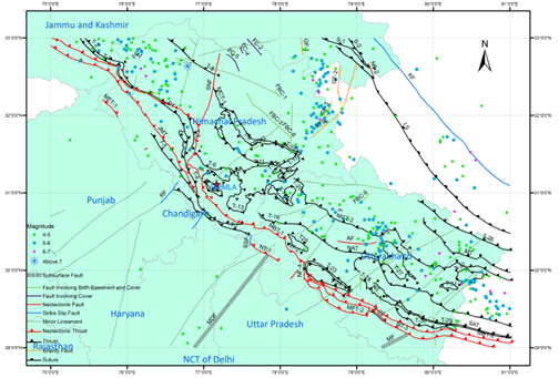
[23]  Shanker, D. and Singh, V. P., Seismic risk analysis for the occurrence of medium size earthquakes in Kangra region of Himachal Pradesh, India. Proc. Indian Natl. Sci. Acad. Part A, 1997, 63, 197–202.
[24]  Shanker, D., R.B.S. Yadav and H.N. Singh (2007), “On the seismic risk in the Hindukush-Pamir-Himalaya and their vi-cinity”, Current Sciences, 92 (1), 1625-1630.
[25]  Shanker, D., Sherif M. Ali and Manisha Singh, (2017). Earthquake Hazard and Engineering Determinations for Indonesian Region Using IMS Network Data, Geosciences, 7(5): 150-155.
[26]  Silver, E.A., Mccaffrey, R., & Smith, R.B. (1983). Collision, rotation and the initiation of subduction in the evolution of Sulawesi, Indonesia. Journal of Geophysical Research, 88, 9407-9418.
[27]  Singh, Manisha, D. Shanker and Sherif M. ALI (2015). Seismic Hazard Assessment in Hindukush-Pamir Himalaya Using IMS Network, Geosciences, 5(3): 81-85.
[28]  Singh, V. P., Duda, J. and Shanker, D., A plausible model for the present day seismicity and tectonic activity in the Hindukush complex zone. J. Asian Earth Sci., 2005, 25, 147–156.
[29]  Spakman, W., & Hall, R. (2010). Surface deformation and slab-mantle interaction during Banda arc subduction rollback. Nature Geoscience, 3, 562-566.
[30]  Spencer, J.E., (2011). Gently dipping normal faults identified with Space Shuttle radar topography data in central Sulawesi, Indonesia, and some implications for fault mechanics. Earth and Planetary Science Letters, 308, 267-276.
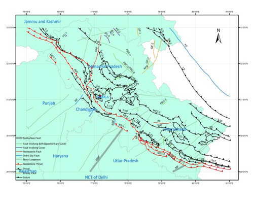
[31]  Valdiya, K.S., (1976). Himalayan transverse faults and folds and their parallelism with subsurface structures of noth Indian Plains; Tectonophysics, 32, 353-386.
[32]  Valdiya, K.S. Rana, R.S. and Sharma, P.K., (1992). Active Himalayan Frontal fault, Main Boundary Thrust and Ramgarh Thrust in Southern Kumaun; Jour. Geol. Soc. India, 40, 509-528.