-
Paper Information
- Next Paper
- Paper Submission
-
Journal Information
- About This Journal
- Editorial Board
- Current Issue
- Archive
- Author Guidelines
- Contact Us
Geosciences
p-ISSN: 2163-1697 e-ISSN: 2163-1719
2017; 7(1): 1-6
doi:10.5923/j.geo.20170701.01

Old Urban Texture Vulnerability Assessment against Earthquake (Case Study: Semnan City)
 Abstract
 Reference
 Full-Text PDF
 Full-text HTML
Roghaye Golvari1, Ahmad Aram1, Mansoure Nikbakht2, Maryam Zare3, Samane Hashemi4, Mahdi Naseri Moghbel1
1MA in Geography and Urban Planning PNU of Boin Zahra, Qazvin, Iran
2MA in Geography and Rural Planning, Tarbiat Moddares University of Tehran, Iran
3MA in Geography and Urban Planning PNU of Babol, Sari, Iran
4MA in Geography and Urban Planning PNU, Qazvin, Iran
Copyright © 2017 Scientific & Academic Publishing. All Rights Reserved.
This work is licensed under the Creative Commons Attribution International License (CC BY).
http://creativecommons.org/licenses/by/4.0/

Due to building's high vulnerability and lack of necessary infrastructures for proper crisis management, the seismic hazards in these urban areas are too high. Also, in order to preparedness and risk reduction before earthquake occurrence, evaluation of vulnerability is necessary. A great earthquake causes numerous losses and damages due to locating the case study on the seismic zoning. The occurrence of natural events such as earthquake have devastating impacts on human life and caused severe losses, destroyed man-made structures and infrastructures that is followed by vast socio-economic losses. Improper distribution of buildings, infrastructures, population and required facilities all over the city is an important reason for settlements and buildings vulnerability. Natural incidents such as earthquake cause life losses and numerous damages in various physical sites and population. In this research we have used analytic-descriptive method. Indeed we believe that we can reduce damages caused by earthquake through proper planning and designing, especially proper urban land usage. Here in order to studding the relation between land usage and urban areas vulnerability against earthquake hazards we have chosen a city called Semnan, collected necessary information, and in the following section would have surveyed ways to reduce damages caused by earthquake.
Keywords: Earthquake, Land Usage, Natural incidents, Vulnerability
Cite this paper: Roghaye Golvari, Ahmad Aram, Mansoure Nikbakht, Maryam Zare, Samane Hashemi, Mahdi Naseri Moghbel, Old Urban Texture Vulnerability Assessment against Earthquake (Case Study: Semnan City), Geosciences, Vol. 7 No. 1, 2017, pp. 1-6. doi: 10.5923/j.geo.20170701.01.
Article Outline
1. Introduction
- In a period of time the phenomenon’s such as earthquake and flood would have been called natural disasters ,in fact this is not an appropriate term, when with raising earthquake mitigation awareness and finding best ways to copping strategies we can reduce significantly the damages and losses caused by unexpected events. For example an earthquake in Bam with magnitude 6/5on the richter scale killed more than 4000 people, but in Japan an earthquake with magnitude 8 on the richter scale kille only one person (caused just one dead). While Japan cities are more populated than Iran cities. This shows that many developed countries in the world through recognizing the most important natural threats and proper planning have gone toward the imigation the impacts of disasters (Ahmadi 1372:10).The occurrence of unexpected events can be most important concern for human life especially in developing countries. During the past 20 years, according to the international organization statistics, more than 1 billion were affected by the quake.As a whole we can devise events into two different categories: events results of natural phenomenon’s and events arising from human activities. Event's occurrence statistics in developing countries show that most of events are result of natural phenomenon’s (Ahmadi, Dastjerdi et al 1382: 24).One of the most devastating natural events is earthquake which has significant impacts on the various aspects of human societies either in economy aspect or in life losses.Iran is located on the Alp-Himalayan seismic belt and its historical records of the evidence show the high probility of strong earthquake occurrence in the future. Earthquake as the most devastating natural event is the most important cause of life losses and economic damages in our country. According to published statistics in the terms of unexpected events, our country is included in 10 disaster-prone countries in the world which more than 30 unexpected natural events out of 40 take place in Iran. Iran has just 1% of world’s population, while 6% of world’ events losses belong to Iran. Indeed, according to this fact that the prediction of exact moment of earthquake occurrence is not possible, people preparedness and awareness of earthquake and how to deal with it has an special importance (zere 1380:13). According to increasing the natural events especially earthquake in different areas of the world in recent years and increasing the damages and life losses due to these events, subject of reducing damages and life losses caused by events and increasing the strength and preparedness to deal with them are of particular importance. So, 1990's is named the decade for natural disasters by the United Nations which include complete studies and researches for prevention to relief activities after disaster occurrence and situating the case study on the faults show the importance of assessing the city vulnerability against the possible earthquake and ask an special study of vulnerable texture and urban possible crisis impacts.Here in this research we examine the issue in the Semnan to reduce the urban areas vulnerability against earthquake and assess it as a tool for more exact programming before events occurrence.
2. Research Methodology
- In this research we have used analytic-descriptive method to called documental information by using the library research methods and the existing data in Semnan municipal, Ministry of Housing and the Urban Development and other related institute. And field study is done in order to complete existing information and data layers formation through questionnaire’s.
3. Research Questions
- - What we should do and what we have done to prevent ant mitigate natural disaster's impacts?- What factors lead to stronger vulnerability of cities?- Is there a relation between raising the vulnerability against an incident and population increasing?
4. Research Assumptions
- a. It seems that there are various factors which effect on the old urban texture vulnerability against natural incidents.b. It seems that old urban texture of Semnan is significantly vulnerable against earthquake in the region.
5. Geographical Distribution of Studied Area
- Semnan city is located on the southern skirts of Albors Mountains and northern edge of Dasht-e-Kavir between 34 degrees and 17 minutes orbit to 37 degrees and 30 minutes to 57 degrees of eastern longitude. Semnan is the capital city of Semnan province and has a population of 126780. It is located 216 kilometers east of Tehran in the way of Tehran to Mashad between Damghan and Garmsar on desert stretches and southern skirts of Alborz mountains (Khodaeian 1381:18). Semnan is a dry and warm area which it's northern side ends to mountains and from south ends to Dasht-e-Kavir. Figure 1 shows the Semnan area.
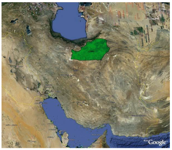 | Figure 1. Semnan city |
6. The Seismicity Records of Studied Area
- Seismicity record is a list of earthquakes occurred in the study area in past. Since Semnan is located on fault 36, it is regarded as one of the most seismically active regions in the country. The maximum intensity of earthquakes and maximum ground acceleration must be shown on an acceleration and intensity maps. Map of acceleration can be used to show maximum ground acceleration for return periods of 50, 200, and 500 years in urban areas. In these maps the soil’s condition are shown on the basis of three categories of soft soils, saturated soils and rocky or very hard soils, therefore the response spectrum based on geological studies for each urban area is estimated. In areas that surface faulting, landslides or liquefaction may occur, separate maps must be provided to evaluate the landslides and secondary effects possibility such as liquefaction into roads by Geotechnical Engineering. (Mashhadizadeh Dehaghani, 2002: 15). The possibility of floods occurrence, caused by landslides tectonic deformation which stops water flow, should be investigated and then the places which are likely for occurrence of flood and earthquake materials flowing must be indicated on other maps (Memarian, 2002:38). This information on separate maps should be combined with micro-zonation maps for planners. The resulting maps illustrate a set of risk factors in different regions. Micro-zonation maps show areas that are exposed to the same level of risk factors in details.Seismic record provides information about the maximum intensity of earthquakes occurred in urban areas during previous earthquakes. In small urban areas, maximum intensity is achieved through a single load, but in large areas this information is related to the maximum intensity of the earthquake and their damage and the possible interaction between them and soil conditions during the previous incidents (Ahmadi, 1997:41). The most devastating earthquake in the history of Iran happened in the region of Ghomes or current Semnan in the year 856 AD and about 200 thousand people were killed during it. According to statistical studies and theoretical studies occurrence of earthquake with 8 degrees Mercalli in the region is possible. Since Semnan is a foothill town and located on the southern slopes of the Alborz Mountain the risk of earthquakes is high in the region, so it is necessary to retrofit buildings and also necessary steps must be taken before and after the earthquake disaster.
7. Region Tilt
- Semnan is located in the Northern part of the alluvial fan with the 1-3 percent tilt. General slope is from North to South. The head of the Semnan alluvial fan is consistent with Semnan River Basin in Northern part of city (near Jahad Sq.) and its base is toward the South, which includes the villages in Southern of Semnan (Khodaian, 2002: 25). Semnan River branches with their drainage system (North-South direction) carry the stones from the mountains to the basin and then with decreasing of slope, the handling power will be reduced. The water flow will form branches in low land area and form their alluvial fan after leaving their alluvial deposits. Semnan is located on the alluvium of this large alluvial fan. Tehran-Mashhad road cuts the Semnan alluvial fan base and Semnan-Shahmirzad way passes from the alluvial fan mouth. The alluvial fans on which Semnan has been establishment over is rugged and undulating and the convexity is the result of water decrease in recent years since the new floods could not carry the alluvium to the first alluvial fans and new alluvium have been left on the surface. And every time the portability power is reduced and finally it has cause the convex surface on the alluvial fan. (Abdolhossein, Khodaian, 2002:32)The thickness of Semnan alluvial fans, as usual, is reduced from the top to the base. The top part of Semnan alluvial fan, in Northern part, is made of large boulders and the fine materials cover all around them as cement. This form shows the flooding structures since there is no clear and specific layer. The grains and stone, which are close to the base, are smaller and more similar and are normally made of silt and clay. The alluvial fan material components are associated with the Northern Mountains of Semnan.Semnan is regarded as one of the most vulnerable areas against the earthquake due to some issues such as the deposition of sediments in Semnan plain from top to base which made relatively steep slopes, coarse sediments with high permeability in Northern parts of city, gentle slopes with fine sediment and low permeability, rising of groundwater and neighboring the faults which are mostly active. There are some issues adding to the sensitivity including the construction of high-rise buildings, urban and rural road network, sewage disposal facilities and the establishment of industrial centers (Khodaian, 2002:29).
8. The Procedure of Assessing the Vulnerability of Urban Areas in Semnan
- Semnan fault is located in the northern Semnan, and separating the Alborz Mountains from central Iran. This fault is spread to Damghan from East and to Deh Namk Plains in Garmsar from west. Since Semnan fault is an active and nationwide fault, it makes the Semnan vulnerable. Also indiscriminate construction of high buildings, regardless of the geotechnical characteristics has wasted the national capital, have negative effects on the process of retrofitting buildings and has made the reason of vulnerability of the high-rise building clear and indicate the critical parts of the city regarding construction (Khori et.al, 2007: 8).Semnan development and uncontrolled construction in recent decades have been incompatible with earthquake risk. Scientifically valid studies and laboratory analysis have shown that many of the existing buildings in the city of Semnan are vulnerable to intense earthquake. In order to reduce the damages and losses caused by the earthquake, major programs for the rehabilitation and retrofitting of buildings, vital installations, and infrastructures must be prepared and implemented. But for such programs, vulnerable situation and locations must be identified in Semnan. For analyzing the vulnerability, a holistic approach must be taken and all aspects of vulnerability should be considered since the incidents, as it has been mentioned before, effect all existing systems in Semnan. Analyzing the vulnerability in Semnan means investigating all urban factors and their condition in a dangerous incident. So following issues will be studied in analyzing the vulnerability:A) Study the natural environment B) Examine the seismic history of the regionC) Classifying the InfrastructureD) Socio-cultural studiesE) Economic studiesSemnan as a gathering place for the human population is not an exception, so serious steps must be taken to reduce the vulnerability of this city against earthquakes. Regarding the location of Semnan, which is in a relatively high risk region, occurrence of an intense earthquake in the city will be results in huge casualties and damages. This risky condition makes the necessity of preparation for crisis caused by earthquake clear. In addition the lack of attention to the correct positioning and development planning and lack of planning for the uncontrolled growth make a lot of problems for this city regarding the safety issues. And development of Semnan on the main fault can makes the damages more severe (Khori et.al, 2007: 9).
9. Semnan Urban Texture
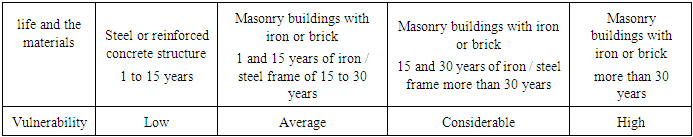
- Considering the age of the building and combine it with the type of structures, the analyzing process will be determined. Useful life of buildings in Iran is estimated about 30 years. The old building will have higher vulnerability (Hatami Nejad et.al, 2009: 12). Most of the southern part of the study area has a worn and old texture and constructions are illegal.1. The old, worn and highly vulnerable texture made of some materials such as clay, wood and clay.2. The middle aged texture without strength made of the brick and iron and cement.3. The new texture are not constructed based on regulations associated with earthquakes.4. The new texture with average strength5. The new texture with high strength.The following table shows the classification based on the life and the materials of the building:
|
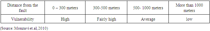
10. The Vulnerability Caused due to Closeness to the Fault
- The vulnerability increase as building get closer to the fault and the risk will decrease by getting far from it. Earthquake experts consider the minimum of 300 meters distance from the fault. Locating farther than this range, the structures behavior is just like other buildings far from faults. (Coburn, Spence, 2003:541)The following table shows the distance from the faults and vulnerabilities in the study area:
|
11. The Geotechnical Vulnerability Characteristic of the Area
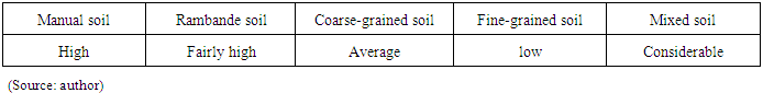
- Geotechnical conditions is one of the most important environmental parameters during earthquakes considering their behavior against seismic waves. The hard and tough geotechnical conditions reduce the transmission power of the earthquake waves and as a result destruction power will be decrease (Alexander, 2002:39).The sedimentation process in Semnan alluvial fan, mainly resulting from climatic changes in the Quaternary period, is created deposits with high thickness and different physical and chemical diversity, and are introduced as problematic soils from geotechnical point of view these days. These types of soils have problems for construction of buildings, especially high-rise buildings. To prevent possible damages, their behavior against stresses and loadings must be studied carefully. The most important characteristics of soils in the city of Semnan in terms of construction, especially the construction of high-rise buildings, is manual soils in different areas of the city which are hidden now due to leveling and other development activities. Soils of areas near the active faults such as the Rosbeh town near the Semnan faults in the Northern part of the city or Industrial Town’s soils near Atari fault are unstable in long term due to the tectonic movements and can be a significant problem and it can cause crisis especially for building and structures (Khodaian et.al, 2011: 15). Fine sediment with high water levels in southern part of the city and coarse sediments with significant slope in northern part of the city make the problematic soils which their behavior against stress and loading should be studied carefully.The following table shows the vulnerability from geological perspective.
|
|
|
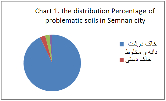 | Figure 3. Location of problematic soils in Semnan city regarding geological studies |
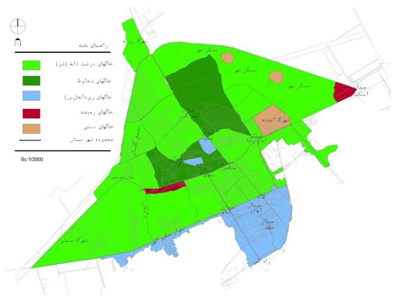 | (Source: Kodaian et.al, 2011) |
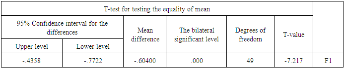
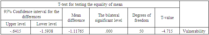
12. Hypotheses Examination
- The conclusion of the first hypothesisThe first hypothesis: It seems that the physical-spatial indices are effective factors in vulnerability of old texture of Semnan city.According to the average values obtained from tests performed for the first hypothesis and significance level (sig) which is lower than 0.05, it is concluded at 95% level that physical-spatial indices are effective factors in vulnerability of old texture of Semnan city.So our research hypothesis which regards the physical-spatial parameters as the most important factors in studied area, is approved. The conclusion of the second hypothesisIn this section we consider the second hypothesis, which is “Urban texture of Semnan is significantly vulnerable in case of earthquake in region”. According to the average values obtained from tests performed for the first hypothesis and significance level (sig) which is lower than 0.05, it is concluded at 95% level that physical-spatial indices are effective factors in vulnerability of old texture of Karaj city.
13. Conclusions
- Currently due to expansion of city toward North and constructing building and neighboring the active faults of Atari in south and Semnan Fault in north, the city is at the high seismic risk. Based on Earthquake Regulation 2800, this city is categorized in high risk level.Due to the high vulnerability of buildings in old texture of Semnan, new designs and widening the ways for making the traffic flow and helping services in emergencies easier and improve accessibility, should be considered. Also vulnerable building must be identified, prioritized and categorized, and then in case of economic justification they must be retrofitted by applying incentive policies and the facilities. Encouraging people to bound themselves to safety instructions and the importance of national laws and regulations; encouraging and promoting the use of different tools; improving public awareness and providing appropriate programs and public education for emergencies are absolutely useful and they should not be forgotten in normal condition and before the earthquake because studying the previous earthquakes indicates that at least one intense earthquake occurs each ten years.Preventing irregular migration and centralization, which prevents the accumulation of population size and resources, is very useful in reducing losses. Also from defensive point of view, centralizing the facilities in one place is not correct strategy. The results of these researches show that, the increase in some factors such as land slope, buildings age and population density increase the vulnerability. And increase in some factors such as distance from fault and better accessibility decrease the vulnerability.