-
Paper Information
- Next Paper
- Paper Submission
-
Journal Information
- About This Journal
- Editorial Board
- Current Issue
- Archive
- Author Guidelines
- Contact Us
Geosciences
p-ISSN: 2163-1697 e-ISSN: 2163-1719
2015; 5(1): 1-7
doi:10.5923/j.geo.20150501.01
Geochemical Analysis of the Reservoir Rocks of Surma Basin, Bangladesh
 Abstract
 Reference
 Full-Text PDF
 Full-text HTML
Md Shofiqul Islam1, Mosarraf Hosain1, Yeasmin Nahar Jolly2, Mohammad Shahedul Hossain1, Shirin Akter2, Jamiul Kabir2
1Department of Petroleum and Mining Engineering, Shahjalal University of Science and Technology, Sylhet, Bangladesh
2Chemistry Division, Bangladesh Atomic Energy Commission, Dhaka Center, Dhaka, Bangladesh
Correspondence to: Md Shofiqul Islam, Department of Petroleum and Mining Engineering, Shahjalal University of Science and Technology, Sylhet, Bangladesh.
| Email: |  |
Copyright © 2015 Scientific & Academic Publishing. All Rights Reserved.
Geochemical analysis of three major gas fields (Kailastila (Well 2), Rashidpur (Well 4) and Fenchuganj (Well 2)) of the Surma Basin has been performed in this study to characterize source rocks and to understand the composition, rock types, and environment of accumulation of sediment of the basin. The XRF analytical result shows that the rock samples are comprised of moderate to high SiO2 contents (50–58%; on average 55%) with a significant amount of Al2O3 (~23%). The SiO2 content and the SiO2/Al2O3 ratio of the samples reflect the intermediate quartz richness. In trace element concentration, Arsenic (As) in the reservoir rocks is more than the permissible limit of WHO. Analyses using different discriminating diagrams show that the reservoir rocks of the Surma basin are mostly greywackey to litherenite. These rocks are deposited under active continental margin with quartzose provenance.
Keywords: Geochemical analysis, Surma basin, Gas field, Reservoir rock, Active continental margin
Cite this paper: Md Shofiqul Islam, Mosarraf Hosain, Yeasmin Nahar Jolly, Mohammad Shahedul Hossain, Shirin Akter, Jamiul Kabir, Geochemical Analysis of the Reservoir Rocks of Surma Basin, Bangladesh, Geosciences, Vol. 5 No. 1, 2015, pp. 1-7. doi: 10.5923/j.geo.20150501.01.
Article Outline
1. Introduction
- The geochemical analysis is the method through which scientists discover and unravel the chemical compounds that make up the earth, its atmosphere, and its seas. Geochemical analysis can predict where petroleum, metals, water, and commercially valuable minerals can be located. In recent years, petroleum geochemical analysis has been developed to characterize source rocks and to understand the origin, migration, and accumulation of petroleum. Geochemical and their solutions could yield tremendous competitive advantages in exploration and production. It is most powerful when used by other disciplines, such as seismic sequence stratigraphy and reservoir characterization.The Surma Basin of Bangladesh (Figure 1) experienced a variety of sediment facies, indicating a range of depositional environments during the Neogene time [1]. Furthermore, during the Miocene time, the Sylhet Basin has a noticeable subsidence and marine transgression. The transgression of the Miocene certainly affected the coastline. It is believed that the Surma Basin has undergone two successive phases of evolution; the marine transgressive phase, followed by a regressive phase resulting in a series of continental fluvio-deltaic to marginal marine sedimentation during the Neogene. The Great Himalayan Orogeny and related tectonics subject the Surma Basin during the Miocene-Pliocene times. However, major changes in sea level for Neogene are transgressive-regressive phenomena suggested by [1]. Moreover, Bandy [2] pointed a marked rise in sea level would have caused a marine transgression.
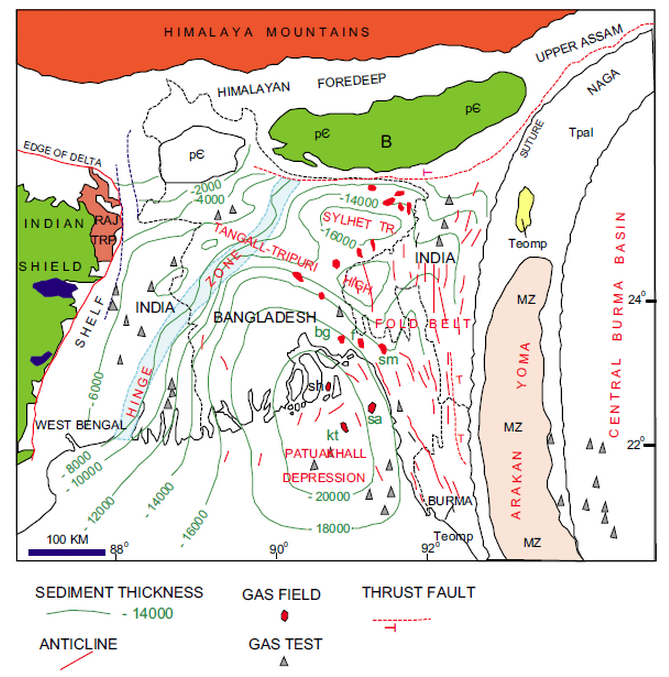 | Figure 1. Generalized geological map of Bangladesh and adjoining area. Surma Basin is same as Sylhet Trough (after [13]) |
2. Overview of the Study Area
- Sylhet Trough (Surma Basin) (Fig. 1) Covers the northeastern part of the Bengal Basin, representing a promising petroleum bearing basin in the Southeast Asia. The basin is bounded on the north by the Shillong plateau, on the east and southeast by the Chittagong-Tripura fold belt of the Indo-Burman ranges and on the west by the Indian Shield platform, to the south and southwest it is open to the main part of the Bengal Basin. The thickness of the late Mesozoic and Cenozoic strata in the Surma Basin range is from about 13 to 17 km [11, 12], and much of this group is Neogene in age. Considerable interest has been focused over the past few decades concerning the geological investigation of the Surma Basin due to its petroleum prospective. There are several gas fields have been discovered within the basin.Considerable contributions have been made by several investigators in relation to the regional geology, petroleum prospects, sedimentology and tectonic evolution of individual parts of the basin and adjoining areas (e.g. [1, 6, 12-19]. Surma Group (middle to late Miocene) consists of alternating sandstones, siltstones and mudstones and is lithologically divided into the mostly arenaceous Bhuban Formation and the dominantly argillaceous Bokabil Formation (Fig. 2). The Surma Group accumulated in interdeltaic to open marine depositional environments [20, 21].
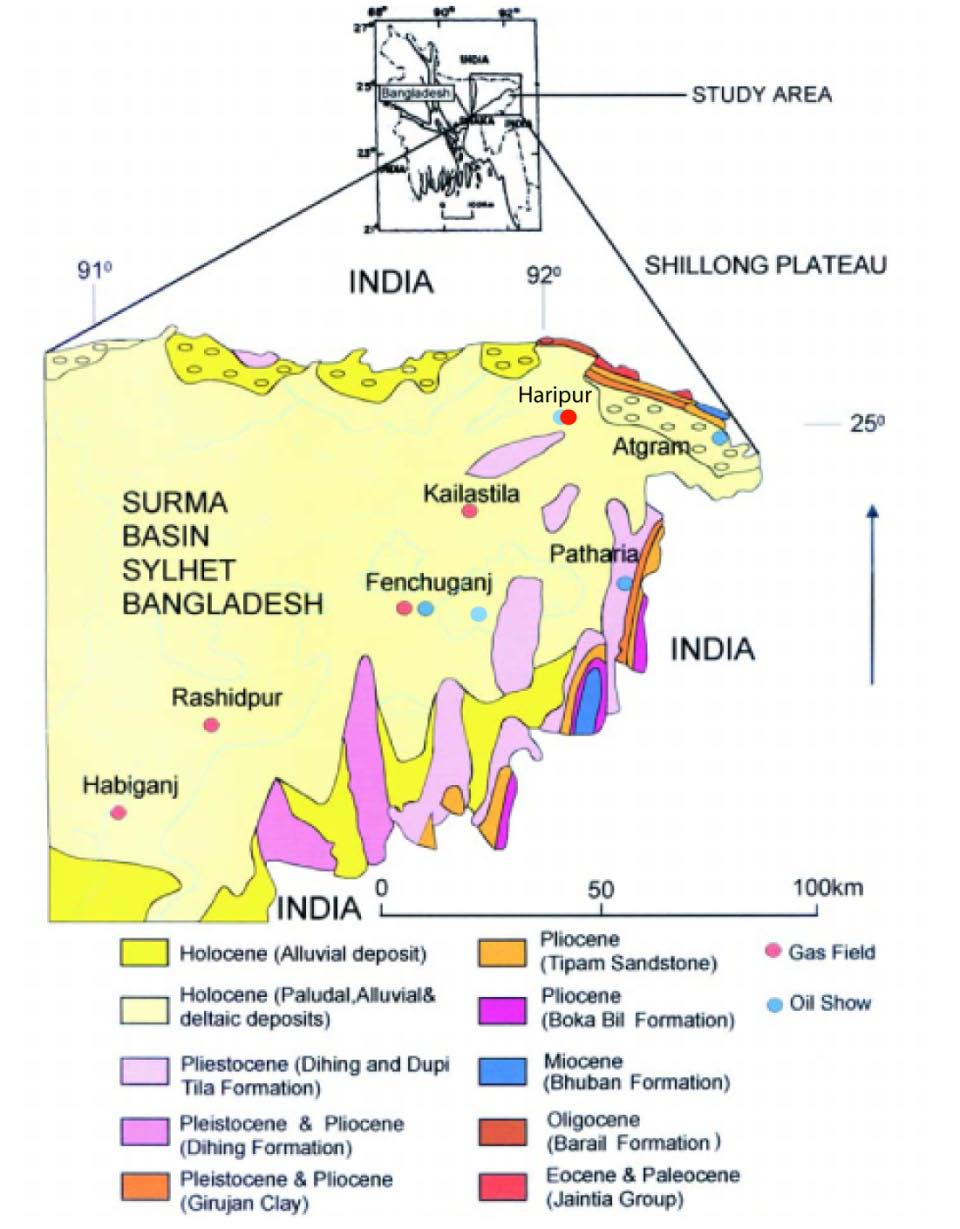 | Figure 2. Map of the Surma Basin, Sylhet, Bangladesh with some prominent gas fields (after [1]) |
3. Materials and Methods
- Twelve (12) core sample has been collected from core storage at Chittagong of BAPEX (Bangladesh Petroleum Exploration & Production Company Limited) are given in the Table 1.
4. Result and Discussion
- Rock type analysisMajor element's data (Table 2) show that sandstones have moderate to high SiO2 contents (50–58%; on average 55%) with a significant amount of Al2O3 (~23%). However, the most commonly used geochemical criteria of sediment maturity are the SiO2 content and the SiO2/Al2O3 ratio [24], reflecting the intermediate quartz richness. However, the chemical maturity is the alkali content (Na20 + K2O), also a measure of the feldspar content. The chemical maturity can be measured using Na2O/K2O ratio. Pettijohn et al. [25] proposed a classification for terrigenous sands based upon a plot of log(Na2O/K2O) vs log(SiO2/Al2O3). This diagram is particularly shows the relationships between elemental composition, mineralogy and rock type, and is widely being used. Using the diagram, our analyzed samples are graywacke to litharenite sandstone (Fig. 3). However, the Na2O vs K2O discrimination diagram (after Crook, 1974 [26]) shows the intermediate richness of quartz (Fig. 4).
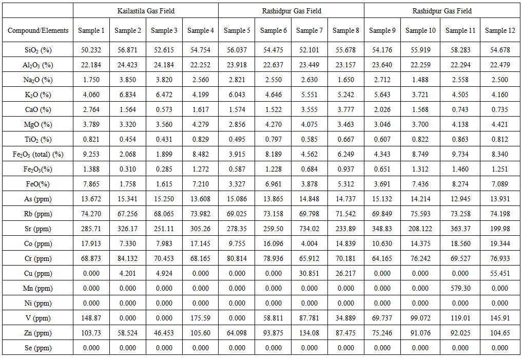 | Table 2. Major element analysis of reservoir rocks of the Surma Basin |
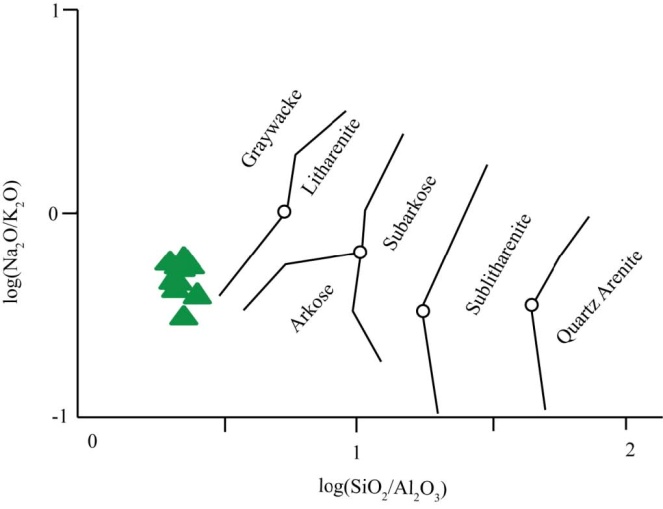 | Figure 3. The classification of terrigeneous sandstones using log(Na2O/K2O) vs log(SiO2/A12O3) from [25], the boundaries drawn using [27] |
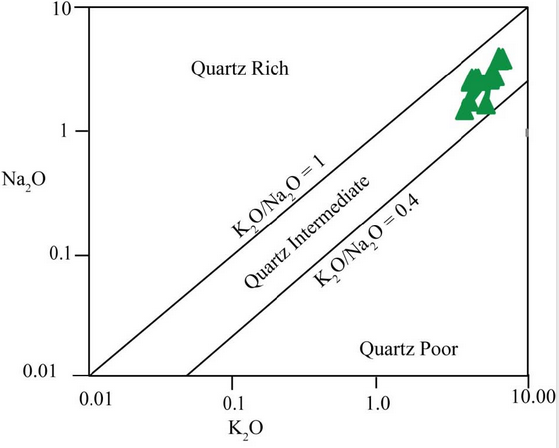 | Figure 4. The K2O vs Na2O discrimination diagram after [28] for sandstone-mudstone suites and showing the fields for an abundance of quartz |
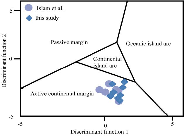 | Figure 5. The discriminant function diagram for sandstones after [28], showing fields for sandstones from passive continental margins, oceanic island-arcs, continental island-arcs and active continental margins |
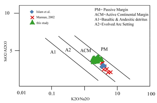 | Figure 6. The log (SiO2/Al2O3) vs (K2O/Na2O) discrimination diagram after [29] for sandstone-mudstone suites |
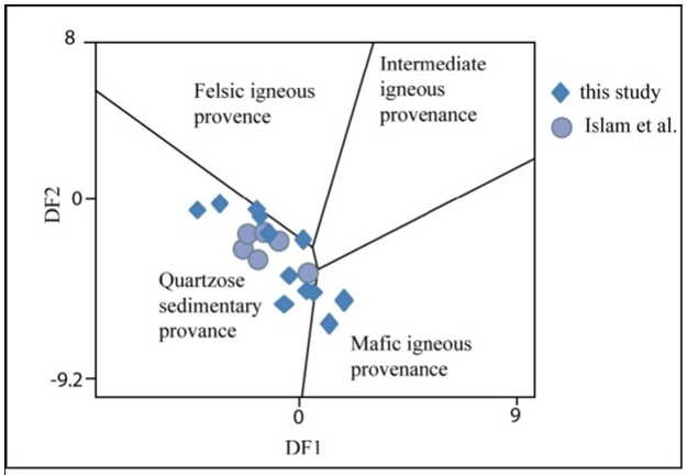 | Figure 7. The discriminant function diagram for the provenance signatures of sandstone-mudstone suites using major elements after [37] |
5. Conclusions
- In the present study there are twelve rock samples from different depth were analyzed. Geochemical of the rock samples revealed the rock type, depositional setting, sedimentation, and tectonics of the reservoir rock formation. Geochemical study indicates that the rock samples are enriching of quartz with a significant amount of aluminium oxide. Most of the samples are grayacke to litharenite in composition with the richness of quartz. Geochemical results are indicative for active continental margin deposition of the sediment under quartzose sedimentary provenance. However, the present result is comparable to previous studies of the Surma Basin.
ACKNOWLEDGEMENTS
- The authors are grateful to Bapex authority for providing samples for analysis. Authors are also grateful to the Bangladesh Atomic Energy Commission for XRF facility at their laboratory. This research work was conducted with financially supported by the SUST Research Center.
References
| [1] | Mannan, M.A. (2002) Stratigraphic evolution and geochemistry of the NeogeneSurma Group, Surma Basin, Sylhet, Bangladesh, PhD Dissertation, Department of Geology, University of Oulu. |
| [2] | Bandy O.L. (1968) Cycles in Neogenepaleoceanography and eustatic changes: Palaeogeog. Palaeoclimate and Palaeoecology 5, 63–76. |
| [3] | Bakhtine M.I. (1966) Major tectonic features of Pakistan Part II. East Prov. Science India 4, 89–100. |
| [4] | Alam M. (1972) Tectonic classification of Bengal Basin. Geological Society of America Bulletin 83, 519–522. |
| [5] | Khan, M.A.M., Ismail, M. and Ahmad, M. (1988) Geology and hydrocarbon prospects of The Surma Basin, Bangladesh: Seventh Offshore Southeast Asian Conf. Singapore, pp.364–378. |
| [6] | Johnson, S.Y. and Alam, A.M.N. (1991) Sedimentation and tectonics of the Sylhet trough, Bangladesh. Geological Society of American Bulletin 103, 1513–1527. |
| [7] | Imam, M.B. (1987) Implication of shale diagenesis on cementation of reservoir sandstonein the NeogeneSurma Group of Bengal Basin. Journal Geological Society of India 30, 447–492. |
| [8] | Imam, M.B. (1989) Comparison of Burial Diagenesis in some Deltaic to Shallow Marine Reservoir Sandstones from different Basins. Journal Geological Society of India 33, 524–537. |
| [9] | Imam, M.B. (1993) Mineralogy and clay diagenesis of Neogeneshales from Patharia-5 and Sitakund-1 wells, eastern folded belt of Bangladesh. Report of Bangladesh Petrol Inst under Institutional cooperation project NORAD BGD-023, pp.97. |
| [10] | Imam M.B. (1994) X-Ray Diffraction Study on NoegeneShales from Patharia Anticline, Eastern Bangladesh, with emphasis on Smectite clay Dehydration and Implications. Journal Geological Society of India 44, 547–561. |
| [11] | U.S Geological Survey -Petrobangla cooperative assessment of undiscovered natural gas resources of Bangladesh, 2001. U.S. Geological Survey Bulletin 2208-A, pp119. |
| [12] | Evans P (1964) The tectonic framework of Assam. Journal Geological Society of India 5, 80–96. |
| [13] | Hiller, K. and Elahi, M. (1984) Structural development and hydrocarbon entrapment in the Surma Basin, Bangladesh (northwest Indo-Burman fold belt): Singapore Fifth Offshore Southwest Conference pp.656–663. |
| [14] | Shamsuddin, A.H.M and Abdullah S.K.M, 1997. Geologic evolution of the Bengal Basin and its implication in hydrocarbon exploration in Bangladesh. Indian Journal of Geology, Vol.69, No. 2, pp 93-121 |
| [15] | Gani, M.R., Alam, M.M., 1999. Trench-slope controlled deep-sea clastics in the exposed lower Surma group in the southeastern fold belt of the Bengal Basin, Bangladesh. Sedimentary Geology 127, 221–236. |
| [16] | Gani, M.R., Alam, M.M., 2003. Sedimentation and basin-fill history of the Neogene clastic succession exposed in the southern folded belt of the Bengal Basin, Banladesh: a high resolution sequence stratigraphic approach. Sedimentary Geology 155 (3–4), 227–270. |
| [17] | Alam, M.M., Curray, J.R., Chowdhury, M.L.R., Gani, M.R., 2003. An overview of the sedimentary geology of the Bengal Basin in relation to the regional tectonic framework and basin fill history. Sedimentary Geology 155 (3–4), 179–208. |
| [18] | Chowdhury, K.R., Haque, M.M., Nasreen, N., Hasan, M.R., 2003. Distribution of planktonic foraminifera in the northern Bay of Bengal. Sedimentary Geology, 155 (3–4), 393–406. |
| [19] | Uddin, A., Lundberg, N., 2004. Miocene Sedimentation and Subsidence during Continent–Continent Collision, Bengal Basin, Bangladesh. Sedimentary Geology,164(1–2): 131–146 |
| [20] | Banerji, R.K., 1984. Post-Eocene biofacies, palaeoenvironments and palaeogeography of the Bengal Basin, India. Palaeogeography, Palaeoclimatology and Palaeoecology 45, 49–73. |
| [21] | Reimann, K.-U., 1993. Geology of Bangladesh. Gebruder Borntreger, Berlin–Stuttgart |
| [22] | Goto, A. and Tatsumi, Y. (1994) Quantitative analysis of rock samples by an X-ray fluorescence spectrometer (I). Rigaku Journal 11, 40–59 |
| [23] | Goto, A. and Tatsumi, Y. (1996) Quantitative analysis of rock samples by an X-ray fluorescence spectrometer (II). Rigaku Journal, 13, 20–38. |
| [24] | Potter, P.E. (1978) Petrology and chemistry of modern big river sands. Journal of Geology 86, 423-449. |
| [25] | Pettijhon, F.J. (1975) Sedimentary rocks. 3rd ed. Harper and Row, New York, pp. 682. |
| [26] | Crook, K.A.W. (1974) Lithogenesis and geotectonics: the significance of compositional variation in flyscharenites (graywackes). Society of Economic geology and Paleontology. Mineral. Spececial Publication 19, 304–310. |
| [27] | Herron, M.M. (1988) Geochemical classification of terrigeneous sands and shales from core or log data. Journal of Sedimentary Petrology, 58, 820–829. |
| [28] | Bhatia, M. R. (1983) Plate tectonics and geochemical composition of sandstones. Journal of Geology. 91, 611–627. |
| [29] | Bhatia, M.R. and Crook, K.A.W. (1986) Trace element characteristics of graywackes and tectonic setting discrimination of sedimentary basins. Contributions to Mineralogy and Petrology 92, 181–193. |
| [30] | Islam, M.S., Alam, M.M., Biswas, P.K., Petrography and geochemical analysis of Fenchuganj Well-2, Sylhet, Bangladesh. Submitted (under review), SUST journal of Science and Technology |
| [31] | Chandra U. (1978) Seismicity, earthquake mechanisms and tectonics along the Himalayan mountain range and vicinity. Physic of Earth and Planetary International 16, 109–131. |
| [32] | Chaudhury H.M. and Srivastava H.N. (1976) Seismicity and focal mechanism of some recent earthquakes in northeast India. Annal di Geophysics 29, 41 – 56. |
| [33] | Molnar G. (1984) Structure and Tectonics of the Himalaya-Constraints and implications of geophysical data: Earth and planetary Sciences Annual Review 12, 489–518. |
| [34] | Nandy, D.R. and Dasgupta, S. (1991) Seismotectonic domains of northeastern India and adjacent areas. In: Sharma KK (ed) Geology and Geodynamic evolution of the Himalayan collision zone Part II: pp.371–384. |
| [35] | Verma, R.K. (1991) Seismicity of the Himalaya and the northeast India, and nature of continent-continent collision. In: Sharma KK (ed) Geology and Geodynamic evolution of the Himalayan collision zone Part II: pp.345–370. |
| [36] | Khan, M.A.M. (1985) A brief account of the geology and hydrocarbon exploration in Bangladesh. In: Offshore South East Asia Conf, Feb 1980. SEAPEX Session, pp.6. |
| [37] | Basu A. (2003) A perspective on quantitative provenance analysis. In: Valloni, R., Basu, A. (Eds.), Quantitative Provenance Studies in Italy, Memorie Descrittive della Carta Geologica dell’Italia, 61, 11 – 22. |
| [38] | Roser, B. P. and Korsch, R. J. (1988) Determination of the tectonic setting of sandstone-mudstone suites using SiO2 content and K2O/Na2O ratio Journal of Geology 94, 635–650. |