-
Paper Information
- Paper Submission
-
Journal Information
- About This Journal
- Editorial Board
- Current Issue
- Archive
- Author Guidelines
- Contact Us
Geosciences
p-ISSN: 2163-1697 e-ISSN: 2163-1719
2014; 4(1): 13-22
doi:10.5923/j.geo.20140401.02
Geochemical Investigation of Potential Source Rocks for  Agbada Formation, Osioka South Area, Western Niger Delta, Nigeria
 Abstract
 Reference
 Full-Text PDF
 Full-text HTML
E. K. Nyantakyi 1, 2, W. S. Hu 2, J. K. Borkloe 1, 2, R. D. Nagre 3, 4, I. K. Frimpong 3, 5
1Department of Civil Engineering, Kumasi Polytechnic, P.O. Box 854, Kumasi, Ghana
2School of Earth Sciences, Yangtze University, Caidian-Wuhan, 430100, Hubei, China
3Department of Chemical Engineering, Kumasi Polytechnic, P.O. Box 854, Kumasi, Ghana
4College of Petroleum Engineering, Yangtze University, Caidian-Wuhan, 430100, Hubei, China
5College of Geophysics, Yangtze University, Caidian-Wuhan, 430100, Hubei, China
Correspondence to: E. K. Nyantakyi , Department of Civil Engineering, Kumasi Polytechnic, P.O. Box 854, Kumasi, Ghana.
| Email: |  |
Copyright © 2012 Scientific & Academic Publishing. All Rights Reserved.
The study investigated hydrocarbon potential source rock for Agbada formation located in the Osioka south area, Western Niger Delta. Thirty (30) core samples from an appraisal well in Oil Mining Lease, OML 65 were investigated for total organic carbon (TOC), Rock-Eval analysis and vitrinite reflectance. The analytical results of the studied core samples revealed that they have generally good total organic carbon (TOC values ranging between 1.0 and 2.0%) contents, suggesting that there exist conditions in the Osioka south area, Niger delta that favour organic matter production and preservation. The Rock-Eval results indicated that 50% of the samples from Osioka south area consist of Type II kerogen, which are capable of generating both oil and gas at suitable temperature in depth. The remaining half of the samples has Type III kerogen which are capable of generating gas. From the vitrinite reflectance measurements, all the samples from Osioka South area reveal moderate source-rock grade. The Agbada formation can be regarded as having good petroleum source rocks and could be part of a petroleum system if sufficient burial and maturation have occurred.
Keywords: Agbada formation, Core samples, Potential source rocks, Total organic carbon, Rock-Eval, Vitrinite reflectance
Cite this paper: E. K. Nyantakyi , W. S. Hu , J. K. Borkloe , R. D. Nagre , I. K. Frimpong , Geochemical Investigation of Potential Source Rocks for Agbada Formation, Osioka South Area, Western Niger Delta, Nigeria, Geosciences, Vol. 4 No. 1, 2014, pp. 13-22. doi: 10.5923/j.geo.20140401.02.
Article Outline
1. Introduction
- The Niger Delta is considered among the world’s best studied delta provinces. There are three lithostratigraphic units recognized in the Niger Delta namely Akata, Agbada and Benin Formations[1]. Source rock of the Niger Delta hydrocarbon has been a subject of controversy.[1] and[2] proposed the shale of the paralic Agbada Formation as the source rocks, while[3] and[4] argued that in most parts of the delta, the Agbada Formation is immature and suggested the source rock to be the marine shale of Akata Formation which are more matured. There has been much discussion about the source rock for petroleum in the Niger Delta (e.g.[5];[6];[7]; [8];[9];[10]). Possibilities include variable contributions from the marine interbedded shale in the Agbada Formation and the marine Akata shale, and a Cretaceous shale ([3];[5]; [7];[4];[8];[10];[11];[12];[13]). The Agbada Formation has intervals that contain organic-carbon contents sufficient to be considered good source rocks (see data in[7];[14]). The intervals, however, rarely reach thickness sufficient to produce a world-class oil province and are immature in various parts of the delta ([5];[11]). Based on organic-matter content and type,[5] proposed that both the marine shale (Akata Formation) and the shale interbedded with paralic sandstone (lower Agbada Formation) were the source rocks for the Niger Delta oils. [6] used ab-hopanes and oleananes to fingerprint crude with respect to their source--the shale of the paralic Agbada Formation on the eastern side of the delta and the Akata marine-paralic source on the western side of the delta.[7] further constrained this hypothesis using geochemical maturity indicators, including vitrinite reflectance data that showed rocks younger than the deeply buried lower parts of the paralic sequence to be immature.[8] argued that the migration efficiency from the over-pressured Akata shale would be less than 12%, indicating that little fluid would have been released from the formation. They derived a different thermal maturity profile, showing that the shale within the Agbada Formation is mature enough to generate hydrocarbons.[10] conclude that the source organic matter is in the deltaic offlap sequences and in the sediments of the lower coastal plain. Their hypothesis implies that both the Agbada and Akata Formations likely have disseminated source rock levels, but the bulk will be in the Agbada Formation. In deep water, they favor delta slope and deep turbidite fans of the Akata Formation as source rocks. The organic matter in these environments still maintains a terrestrial signature, however, it may be enriched in amorphous, hydrogen-rich matter from bacterial degradation.[9] in a detailed source-rock study on side-wall core and cuttings from the Agbada-Akata transition or uppermost Akata Formation, concluded that there are no rich source rocks in the delta. With respect to oil potential, Bustin claims that the poor source-rock quality has been more than compensated by their great volume, excellent migration pathways, and excellent drainage. The oil potential is further enhanced by permeable interbedded sandstone and rapid hydrocarbon generation resulting from high sedimentation rates. The total organic-carbon (TOC) content of sandstone, siltstone, and shale in his study is essentially the same (average of 1.4 to 1.6% TOC). The content, however, seems to differ with age of the strata—a trend of decreasing content with decreasing age (average of 2.2% in the late Eocene compared to 0.9% in Pliocene strata). Bustin’s Eocene TOC average compares well with the averages of 2.5% and 2.3% obtained for Agbada-Akata shales in two wells[15].[7] report TOC values from 0.4 to 14.4% in both onshore and offshore paralic sediments.[14] report values as high as 5.2% in paralic shales from the western part of the delta. The higher TOC contents are limited to thin beds and are only easily recognized in conventional cores[10]. The organic matter consists of mixed maceral components (85-98% vitrinite with some liptinites and amorphous organic matter)[9]. There is no evidence of algal matter and the shales are low in sulfur (0.02 to 0.1 %). Hydrogen indices (HI) are quite low and generally range from 160 to less than 50 mg HC/g TOC.[16] believe that Bustin’s average of 90 mg HC/g TOC underestimates the true source-rock potential because of matrix effects on whole-rock pyrolysis of deltaic rocks.[17] report HI values of 232 for immature kerogen isolates from Agbada-Akata shales. HI values over 400 have been measured[18]. Pristane/phytane in extracts range between 2 and 4[9]. Bustin found that both HI values and pristane/phytane change with stratigraphic position similarly to TOC contents (lower values in younger strata). He attributes these stratigraphic trends in organic-matter to increased dilution as sedimentation rates increased and possibly an increase in oxidizing conditions of the depositional environment. Organic geochemistry assesses if the rocks in an area are of the right quality and the right amount to form oil or gas. It is therefore important to recognize these rocks in the early stages of petroleum exploration for their evaluation. The presence of more than one source rock in an area makes it more attractive. Estimates of how prolific the source rock has been and some indications of the nature of the hydrocarbon products will be useful for effective hydrocarbon exploration.
1.1. Geology of the Niger Delta
- The Niger Delta, situated at the apex of the Gulf of Guinea on the west coast of Africa, covers an area of about 75 000 km2. The geology of the tertiary Niger Delta province has been described by several workers ([1];[19];[3];[20];[5]; [10]; [21]). Basement tectonics related to crucial divergence and translation during the late Jurassic and Cretaceous continental rifting probably determined the original site of the main rivers that controlled the early development of the Delta. The Cenozoic development of the delta is also believed to have taken place under approximate isostatic equilibrium. The main depocenter is thought to have been at the triple junction between the continental and oceanic crust where the delta reached a main zone of crustal instability. The Niger Delta is a large arcuate delta of the destructive, wave-dominated type and is composed of an overall regressive clastic sequence which reaches a maximum thickness of about 12 km in the basin centre.
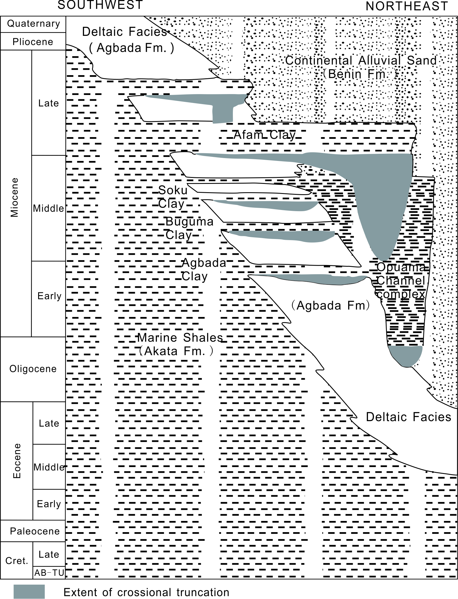 | Figure 2. Stratigraphic column showing formations of the Niger Delta[26]. Modified from[10] |
1.2. Hydrocarbon Source Rock
- There has been much discussion about the source rock for petroleum in the Niger Delta which has reflected in[6];[7]; [8];[9];[10]. Possibilities include variable contributions from the marine interbedded shale in the Agbada Formation, the marine Akata shale and the Cretaceous shale[3];[25];[7];[8]; [10];[11];[12];[13].The Agbada Formation has intervals that contain organic-carbon contents sufficient to be considered good source rocks. The intervals, however, rarely reach thickness sufficient to produce a world-class oil province and are immature in various parts of the delta[5];[11]. The Akata shale is present in large volumes beneath the Agbada Formation and is at least volumetrically sufficient to generate enough oil for a world class oil province such as the Niger Delta. In the case of the cretaceous shale, it has never been drilled beneath the delta due to its great depth; therefore, no data exist on its source-rock potential[5].
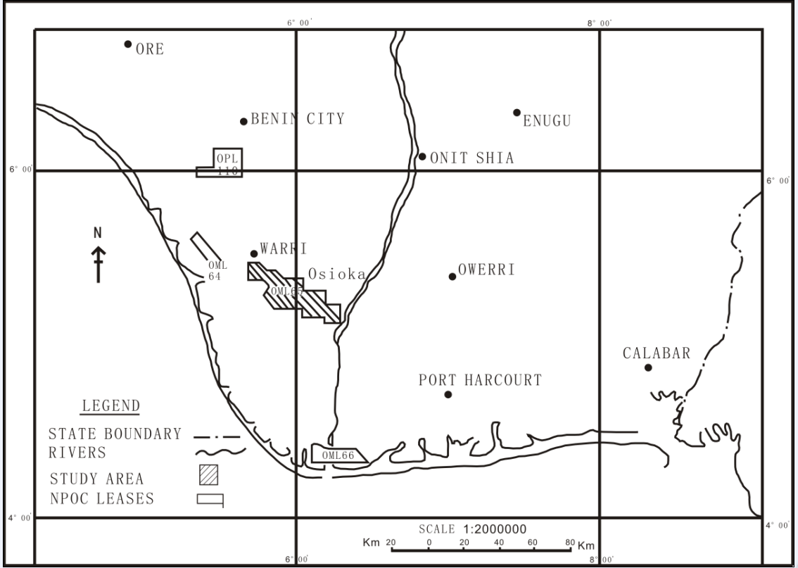 | Figure 1. Location Map of study Area |
2. Methodology
2.1. Samples
- Thirty (30) core samples were recovered from an interval of an appraisal well within the Osioka south area, Western Niger Delta. The sample locations are shown in Fig. 1. The samples numbers and depth details are summarized in Table 1. The core samples were taken to the Organic Geochemistry Laboratory, Yangtze University, Wuhan-China. The samples were oven-dried overnight at 110°C, pulverized, and analyzed using TOC/Rock-Eval pyrolysis techniques. The geochemical parameters including total organic content, organic matter type, maturity of organic matter (Ro) were determined in order to characterize the petroleum generation potential of the source rock.
2.1. Total Organic Carbon (TOC) Contents and Rock-Eval Analyses
- The TOC contents, hydrogen index (HI), the oxygen index (OI) and Tmax (temperature of maximum kerogen pyrolysate yield), were determined using Rock-Eval II instrument. The oven was initially kept isothermally at 300°C for 3 minutes during which time the free hydrocarbons were volatilized and the S1 peak was measured by the Flame Ionization Detector (FID). Pyrolysis of organic matter was then performed at 300 – 600°C with a temperature rise of 25°C /min. This is the phase of volatilization of the higher carbon number hydrocarbons compounds (>C40) as well as the cracking of non-volatile organic matter. The hydrocarbons released from this thermal cracking were measured as the S2 peak (by FID). The temperature at which S2 reaches its maximum depends on the nature and thermal maturity of the kerogen and this was measured as Tmax. The CO2 produced from kerogen cracking was trapped in the 300 - 390°C range. Upon further heating, CO2 was released and detected on a Thermal Conductivity Detector (TCD) during the cooling of the Pyrolysis oven (S3 peak). The HI was determined as the yield of reduced products of pyrolysis (S2) relative to the TOC (mg HC/g TOC) and OI is the yield of the oxygen and bound organic carbon (S3).
2.2. Vitrinite Reflectance
- Vitrinite reflectance (Ro) was measured on samples with Corg > 0.4%. In this study, Corg values were all above 0.4%. For microscopic studies, the samples were embedded in an epoxy resin, and a section perpendicular to bedding was polished[27]. The polished blocks were investigated at a magnification of 500× in incident white light and in incident light fluorescence mode, excited by ultraviolet and violet light. The Ro measurements were conducted using a Zeiss Axioplan incident light microscope at a wavelength (l) of 546 nm with a Zeiss Epiplan- Neofluar 50×, 0.85 oil objective. An yttrium aluminum garnet standard was used, with an Ro of 0.889%.
3. Results and Discussions
- The results of the TOC contents and Rock-Eval data for the studied core samples are presented in Table 2. Trend of TOC values of the samples with sample depth numbers (as shown in Table 1) is presented in Figure 3.In order to characterize the organic matter type (kerogen type) of the samples, the modified Van Krevelen diagram (HI versus OI) is displayed in Figure 4. For the evaluation of the generation potential, graphs of PG against TOC[28] and the Rock-Eval HI versus TOC[29] were plotted and shown in Figures 5 and 6 respectively.
|

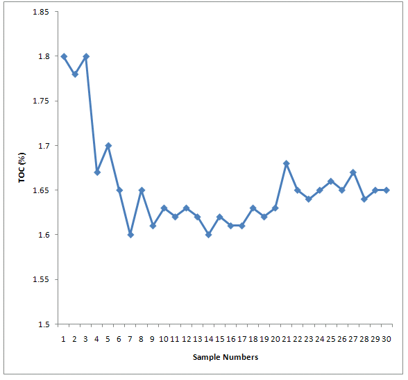 | Figure 3. Trend of TOC values in the studied samples (Numbers 1 – 30) |
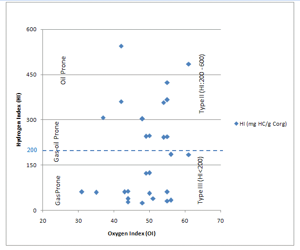 | Figure 4. Modified Van Krevelen diagram showing the organic matter types of the studied samples |
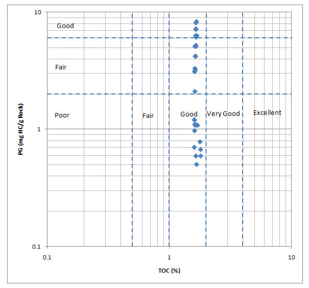 | Figure 5. Generative potential for the studied samples[28] |
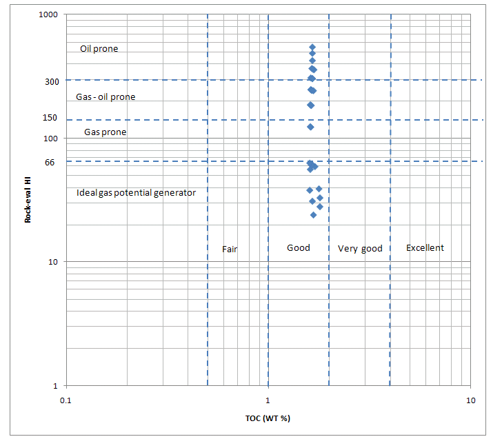 | Figure 6. Generative potential of potential source rocks of Niger delta, Nigeria |
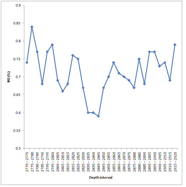 | Figure 7. Maturity, Ro (%) versus Sample Depth Interval (feet) |
3.1. Organic Matter (Kerogen) Type
- The organic matter type is a key important parameter in evaluating source rock potential and has important influence on the nature of the hydrocarbon products ([30];[31];[32]). [33] proposed that, for mature source rock, HI for gas-prone organic matter is less than 150, gas-oil-prone organic matter is ranged between 150 and 300, whereas the oil-prone organic matter is more than 300 HI. Thus, it is very important to determine the kerogen types of the source rocks as they have a first-order control on the hydrocarbon products after maturation. The results from this study showed that 14 samples (with sample Nos. 1-12, 14 and 16) representing 47% have HI values less than 150 which indicate gas-prone organic matter. Twenty three percent (23%) of samples (with sample Nos. 13, 15, 17-18, 20, 23 and 27) have HI values between 150-300 indicating gas-oil prone organic matter. The remainder (with sample Nos. 19, 21-23, 24-26 and 28-30) have HI values are greater than 300 (Table 1) which also indicate oil-prone organic matter. Additionally, 12 samples (with sample Nos. 1-10, 12 and 14) representing 40% have HI values less than 66 mg/ g, indicating ideal potential sources of gas generation. [31] proposed a genetic potential (PG = S1 + S2) for the classification of source rocks. According to their classification scheme, rocks having PG of less than 2 mg HC/g rock correspond to gas-prone rocks or non-generative ones, rocks with PG between 2 and 6 mg HC/ g rock are moderate source rocks, and those with PG greater than 6 mg HC/g rock are good source rocks. Based on the above criteria, 47% samples (with sample Nos. 1-10, 12 and 14-16) with PG less than 2 mgHC/g are either gas-prone rocks or non-generative rocks. Nine (9) samples (with sample Nos. 11, 13, 17-20, 22-23 and 26) with PG values between 2 and 6 mgHC/g are moderate source rocks. Seven (7) samples (with sample Nos. 21, 24-25 and 27-30) representing 23% with PG values greater than 6 mgHC/g exhibit good source rock potential at sufficient depths. The modified Van Krevelen diagram (HI versus OI) (Figure 4) for the studied core samples shows that about half (50%) of the samples from Osioka south area consist of Type II kerogen, which are capable of generating both oil and gas at suitable temperature and depth. The other half (50%) of the samples has Type III kerogen. These results confirmed the findings of previous researchers on the potential source rocks of Niger Delta[9], with respect to variation in kerogen types which may be related to the relative stratigraphic positions of the outcrops within the Niger delta.
3.2. Source Rock Richness and Generation Potential
- The organic matter richness of source rocks is determined usually using the total organic carbon content, which is the total amount of organic material (kerogen) present in the rock, expressed as a percentage by weight (TOC wt.%). By and large, the higher the TOC, the better the chance and potential for hydrocarbon generation. According to[33], the TOC values between 0.5 and 1.0% indicate a fair source-rock generative potential, TOC values varying from 1.0 to 2.0% reflect a good generative potential whilst values between 2.0 and 4.0% refer to a very good generative potential, and rocks with TOC greater than 4.0% are considered to have excellent generative potential. Based on this criterion, the TOC results of rock samples in this study reveal that all the sample sources from Osioka south area (Table 1) have good hydrocarbon generative potential regarding their TOC values of 1.0 to 2.0%. This is demonstrated in the plot of the Rock–Eval HI versus TOC (Figure 6). The good generation potential of all the samples in particular is well supported by the presence of type II & III kerogens (Figure 4). Figure 5 shows the generative potential for the studied samples.
3.3. Maturity of Organic Matter (Ro)
- The Ro values (Table 2) of all samples are plotted against the depth interval in Figure 7. An overview of maturity distribution is provided by Ro data, which is considered to be the most reliable and most commonly used maturity indicator ([34];[35]). According to them, the Ro values between 0.5 and 0.7% indicate low source-rock grade, Ro values varying from 0.7 to 1.0% reflect a moderate source-rock grade, Ro values between 1.0 and 1.3% refer to a high source-rock grade. Based on the above criteria, all the samples from Osioka South area reveal moderate source-rock grade since their Ro values are between 0.7 to 1.0%.
4. Conclusions
- Results of TOC and Rock-Eval analyses of potential hydrocarbon source rocks of the thirty (30) samples in the Osioka south area, offshore Niger delta show that the prevailing conditions favoured organic matter production and/or preservation. This led to high organic matter contents of the samples in all stratigraphic intervals. About 50% of the samples contained predominantly Type II kerogen and were both oil- and gas-prone, and the organic matter content good generative potential. Furthermore, the remaining 50% of the samples contained mainly Type III kerogen and were more gas prone with moderate organic carbon contents and also exhibited good hydrocarbon generative potential. Results of the vitrinite reflectance measurement also revealed that all the samples from Osioka south area were moderate source-rock grade. The Osioka south area, offshore Niger Delta can be regarded as having good petroleum source rocks and could be part of a petroleum system if sufficient burial and maturation have occurred.
ACKNOWLEDGEMENTS
- The authors would like to acknowledge the management of Kumasi Polytechnic, Kumasi headed by the Rector Prof. N.N.N. Nsowah-Nuamah, for providing financial assistance to undertake this study. Special thanks go to Oil & Gas Resource and Digital Geo-Processes, Yangtze University and Research Institute of China National Offshore Oil Corporation for providing the data.
References
| [1] | Short K.C. and Stauble A.J., (1967). Outline of Geology of Niger Delta. Amer. Assoc. Petrol. Geol. Bull. V. 57, p. 761-779. |
| [2] | Frankl E.J. and Cordry E.A., (1967). The Niger Delta Oil Province- Recent Developments Onshore and Offshore: Proc. 7th World Petroleum Cong. Mexico City. V. I b. p. 195-209. |
| [3] | Weber, K. J., and Daukoru, E.M., (1975) Petroleum geology of the Niger Delta Proceedings of the Ninth World Petroleum Congress, Geology: London, Applied Science Publishers, Ltd., 2, 210-221. |
| [4] | Ekweozor C.M. and Daukoru, E.M., (1984). Petroleum Source Bed Evaluation of the Tertiary Niger Delta. Amer. Assoc. Petrol. Geol. Bull. V. 68, p. 390-394. |
| [5] | Evamy BD, Herebourne J, Kameling P, Knap WA, Molley FA, Rowlands PH (1978). Hydrocarbon habitat of Tertiary Niger Delta. Am. Assoc. Petrol. Geol. Bull., 62: 1-39. |
| [6] | Ekweozor, C. M., Okogun, J.I., Ekong, D.E.U., and Maxwell J.R., (1979) Preliminary organic geochemical studies of samples from the Niger Delta, Nigeria: Part 1, analysis of crude oils for triterpanes. Chemical Geology, 27, 11-28. |
| [7] | Ekweozor, C.M., and Okoye, N.V., (1980) Petroleum source-bed evaluation of Tertiary Niger Delta: American Association of Petroleum Geologists Bulletin, 64, 1251-1259. |
| [8] | Lambert-Aikhionbare, D. O., and Ibe, A.C., (1984) Petroleum source-bed evaluation of the Tertiary Niger Delta: discussion: American Association of Petroleum Geologists Bulletin, 68, 387-394. |
| [9] | Bustin, R. M., (1988) Sedimentology and characteristics of dispersed organic matter in Tertiary Niger Delta: origin of source rocks in a deltaic environment: American Association of Petroleum Geologists Bulletin, 72, 277-298. |
| [10] | Doust, H., and Omatsola, E., (1990) Niger Delta, in, Edwards, J. D., and Santogrossi, P.A., eds., Divergent/passive Margin Basins, AAPG Memoir 48: Tulsa, American Association of Petroleum Geologists, 239-248. |
| [11] | Stacher, P., (1995) Present understanding of the Niger Delta hydrocarbon habitat, in, Oti, M.N., and Postma, G., eds., Geology of Deltas: Rotterdam, A.A. Balkema. |
| [12] | Frost, B.R., (1997) A Cretaceous Niger Delta Petroleum System, in, Extended Abstracts, AAPG/ABGP Hedberg Research Symposium, Petroleum Systems of the South Atlantic Margin, November 16-19, 1997, Rio de Janeiro, Brazil. |
| [13] | Haack, R.C., Sundararaman, P., and Dahl, J., (1997) Niger Delta petroleum System, in, Extended Abstracts, AAPG/ ABGP Hedberg Research Symposium, Petroleum Systems of the South Atlantic Margin, November 16-19, 1997, Rio de Janeiro, Brazil. |
| [14] | Nwachukwu,J.I., and Chukwurah, P. I., 1986, Organic matter of Agbada Formation, Niger Delta, Nigeria: American Association of Petroleum Geologists Bulletin, v. 70, p. 48-55. |
| [15] | Udo, O.T., and Ekweozor C.M., 1988, Comparative source rock evaluation of Opuama Channel Complex and adjacent producing areas of Niger delta: Nigerian Association of Petroleum Explorationists Bulletin, 3, n. 2, p. 10-27. |
| [16] | Ekweozor, C M; Daukoru, E M (1994). Northern delta depobelt portion of the Akata- Agbada. (1) Petroleum system, Niger Delta, Nigeria, In, Magom, L.B., and Dow, W.G., eds. The petroleum system- from source to Trap, A. A. P. G. Memoir 60: Tulsa, 599 – 614. |
| [17] | Udo, O.T., Ekweozor, C.M., and Okogun, J.I., 1988, Petroleum geochemistry of an ancient clay-filled canyon in the western Niger delta, Nigeria: Nigerian Association of Petroleum Explorationists Bulletin, v. 3, p. 8-25. |
| [18] | Michael Lewan, U.S. Geological Survey, written communication, 1999. |
| [19] | Weber KJ (1971). Sedimentological aspect of oil fielding the Niger Delta. Geol. Minjbouw, 50: 559-576. |
| [20] | Weber KJ, Mandi J, Pilaar WF, Lehner E, Precious RG (1978). The role of faults in hydrocarbon migration and trapping in Nigeria growth fault structures. 10th Annual Offshore Technology Conference Proceedings, 4: 2643-2653. |
| [21] | Haack RC, Sundararaman P, Diedjomahor JO, Xiao H, Gant NJ, May ED, Kelsch K (2000). Niger Delta petroleum systems, Nigeria, in M. R. Mello and B. J. Katz, eds., Petroleum systems of South Atlantic margins: Am. Assoc. Petrol. Geol. Memoir, 73: 213-231. |
| [22] | Murat RC (1970). Stratigraphy and Paleogeography of the Cretaceous and Lower Tertiary in Southern Nigerian. 1st Conference on African Geology Proceedings, Ibadan University Press, pp. 251-266. |
| [23] | Michele, L W T; Ronald, R C; Michael, E B (1999). The Niger delta petroleum system: Niger delta province, Nigeria, Cameroon, and Equatorial Guinea, Africa. Open-file report 99-50-H. |
| [24] | Uko, E D (1996). Thermal modeling of the Northern Niger delta. Unpublished Ph. D. Thesis, Rivers State University of Science and Technology, Port Harcourt. |
| [25] | Ejedawe, J.E., (1986). The expulsion in the evaluation of petroleum source beds of the Tertiary Niger Delta. J. Pet. Geol. 9, 439-450. |
| [26] | Tuttle, M. L. W., R. R. Charpentier and M. E. Brownfield, 1999, The Niger delta petroleum system: Niger delta province, Nigeria, Cameroon, and Equatorial Guinea, Africa: USGS Open-file report 99-50-H. |
| [27] | Taylor, G. H., M. Teichmüller, A. Davis, C. F. K. Diessel, R. Littke, and P. Robert, 1998, Organic petrology: Berlin, Borntraeger, 704 p. |
| [28] | Ghoria, K. A. R., “Petroleum Source-Rock Potential and Thermal Maturity of the Officer Basin”, Geological Survey of Western Australia, vol. 1, pp. 52-53, 1998. |
| [29] | Walters, C. C., The Origin of Petroleum, in Practical Advances in Petroleum Processing, Volume 1, Springer Science and Business Media Inc, New York, 2006. |
| [30] | Hunt, J. M., Petroleum Geochemistry and Geology, W. H. Freeman, San Francisco, 1979. |
| [31] | Tissot, B. P. and D. H., Welte, Petroleum Formation and Occurrence, Springer Verlag, New York, 1984. |
| [32] | Barker, C., Thermal Modelling of Petroleum Generation: Theory and Applications, Elsevier, New York, 1996.62. |
| [33] | Peters, K. E., “Guidelines for evaluating petroleum source rock using programmed analysis”, The American Association of Petroleum Geologists Bulletin, vol. 70, pp. 318-329,1986. |
| [34] | Dow, W. G., 1977, Kerogen studies and geological interpretations: Journal of Geochemical Exploration, v. 7, p. 77– 99, doi:10.1016/0375-6742(77)90077-2. |
| [35] | Waples, D. W., H. Kamata, and M. Suizu, 1992, The art of maturity modeling: Part 1. Finding a satisfactory geological model: AAPG Bulletin, v. 76, p. 31–46. |