-
Paper Information
- Paper Submission
-
Journal Information
- About This Journal
- Editorial Board
- Current Issue
- Archive
- Author Guidelines
- Contact Us
Geosciences
p-ISSN: 2163-1697 e-ISSN: 2163-1719
2013; 3(5): 143-152
doi:10.5923/j.geo.20130305.01
Revisiting State of Stress and Geodynamic Processes in Northeast India Himalaya and Its Adjoining Region
 Abstract
 Reference
 Full-Text PDF
 Full-text HTML
A. Panthi1, H. N. Singh2, D. Shanker3
1Department of Physics, Nepal, Butwal Multiple Campus, Tribhuvan University, Butwal, Nepal
2Department of Geophysics, Faculty of Science, Banaras Hindu University, Varanasi, India
3Department of Earthquake Engineering, Indian Institute of Technology Roorkee, Roorkee, India
Correspondence to: D. Shanker, Department of Earthquake Engineering, Indian Institute of Technology Roorkee, Roorkee, India.
| Email: |  |
Copyright © 2012 Scientific & Academic Publishing. All Rights Reserved.
The paper investigates to study components of seismicity and prevailing tectonic stress regimes of the considered region by analyzing the earthquake data that occurred during the last 200 years (from 1808 to 2008). For the purpose, northeast India Himalaya and its adjoining regions have been divided into five active regions namely Eastern Syntaxis, Arakan-yoma fold belt, Shillong plateau, Himalayan Frontal arc and Southeastern Tibet by taking into consideration the spatial distribution of seismicity its tectonic complexity. The minimum compressive stress is almost horizontal in the Tibet which indicates that the earthquake generation process is due to the flow of materials in east-west direction. The prevailing regional stress conditions at shallower levels in compression as well as in extension zones extend up to the deeper levels in to the upper mantle especially in southeastern Tibet and Arakan-yoma region. The present findings provide additional information on the seismicity, tectonics, the faulting pattern and the associated ongoing geodynamic processes in the region.
Keywords: Extension Regime, Compression Regime, Syntaxis
Cite this paper: A. Panthi, H. N. Singh, D. Shanker, Revisiting State of Stress and Geodynamic Processes in Northeast India Himalaya and Its Adjoining Region, Geosciences, Vol. 3 No. 5, 2013, pp. 143-152. doi: 10.5923/j.geo.20130305.01.
Article Outline
1. Introduction
- Focal mechanism solution determines the nature and orientation of the stress field that prevailed in the preliminary generation of an earthquake. It is the analytical result of waveforms generated by an earthquake which eventually provide information about the mode in which the seismic energy is released in the hypocentral zone and facilitates to understand the physical and the tectonic conditions. It commonly refers to fault orientation, the seismic slip in relation to plate movement, stress release patterns and the geodynamic process of seismic wave generation. To understand the stress pattern and the geodynamic processes in the eastern segment of Himalayan collision zone and its adjoining regions, a total of 94 focal mechanism solutions have been considered in the present research work. Thirty four focal mechanism solutions have been determined in present work. The remaining 60 solutions are compiled from already published literatures (e.g.[3],[4],[5],[15],[17],[18],[20],[22],[26], Centroid Moment Tensor (CMT) solution). Rastogi et al.[22] determined eleven focal mechanism solutions of earthquakes occurred in Assam-Burma region using P-wave first-motion direction data and reported that the dominant modes of deformation are thrust faulting in the region. Chandra[3] determined eighteen focal mechanism solutions for the earthquakes occurred in Himalayan region using P-wave first motion data and reported thrust faulting pattern in northeast India region. Singh and Shanker[25] have stated that the effect of Tibetan plateau on Burmese Arc tectonics and seismicity distribution cannot be ignored. Several thrusts, lineaments, folded belts are found to be responsible for the earthquake generation in this region. It is believed that high seismic activity in the region is due to northward as well as eastward movement of the Indian plate toward the Eurasia and Burma plates, respectively.
2. Physiographic Location of Study Region
- The Himalayan mountain belt extends from Nanga Parbat (8138 m) in the west to Namche Barwa (7775 m) in the east[14]. This belt trends mostly in NW-SE with a length 2400 km and width vary from 200 to 250 km covering Nepal and some parts of India, China, Bangladesh, Bhutan and Burma. The Himalaya is bounded by Tibetan plateau to the north and Indus- Ganga -Brahmaputra plain to the south. Northeast India Himalaya and its adjoining regions, the eastern part of Himalaya, are focused here to identify the present state of geodynamic processes by using focal mechanism solutions (Fig 1). This region has been considered as complex from geologic and tectonic points of view[1, 7, 9, 19]. The region is seismically potential zone as several large/great damaging earthquakes have occurred in the past. The earthquakes in this region are reported to be associated with MCT, MBT, thrusts, faults and lineaments. The main Himalayan seismic belt is mostly confined with the MCT and MBT[20]. The Indo-Burma region forms complex geology and tectonics. On the basis of physiographic structure, Burma territory has been divided as Eastern Highlands, Central lowlands and Indo-Burma mountain belt (called Indo-Burma Range). Bengal basin lies to the west of Indo-Burma range. The Arakan-Yoma, Manipur, Naga Hills, Lushai and Patkai are the most prominent structure in the Indo-Burma range. The northernmost part of Indo-Burma arc joins with the Himalayan belt and the joint region is outlined a complex structure that forms Syntaxis called Eastern Syntaxis.
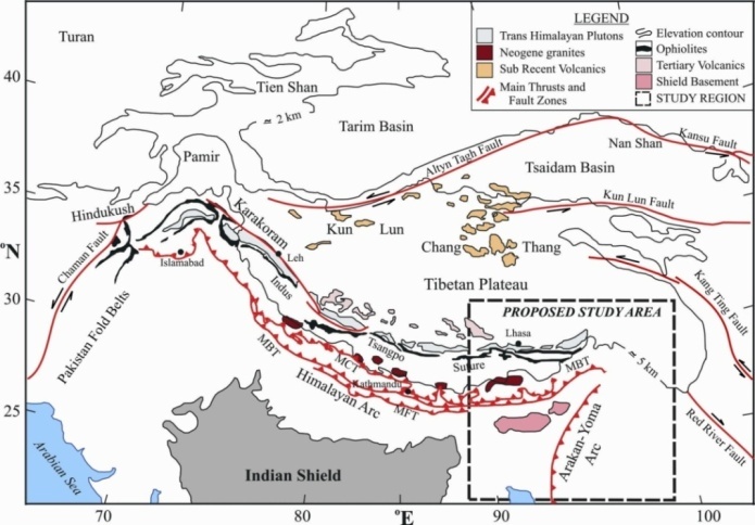 | Figure 1. Map of the Northeast India Himalaya and its adjoining regions (modified after[20]). The map includes the Himalayan arc, Tibetan plateau and surrounding regions showing major tectonic– structural features. MCT (Main Central Thrust); MBT (Main Boundary Thrust); MFT (Main Frontal Thrust) |
3. Seismicity and Stress Pattern
- The Northeast India and the Eastern segment of the Himalaya is seismically one of the most active regions in the world where several large and two great earthquakes have occurred during the past hundred years. Several thrusts, lineaments, folded belts are found to be responsible for the earthquake generation in this region. A total of 560 earthquakes have been listed in the database during the period 1808 to 1962 in the considered region. Gupta et al.[10] have considered the great Shillong earthquake (1897) as the demarcation between the historical and recent seismicity of northeast India region. The seismicity pattern of this region has been studied by a number of researchers[10, 12, 13, 23, 25]. Considering the spatial distribution of earthquakes for the period 1808-2008 and using the information from[8], five seismically active zones are delineated in the northeast India Himalaya and its adjoining regions (Fig. 2.) as: Eastern Syntaxis (I), Arakan Yoma Fold Belt (II), Shillong Plateau (III), Himalayan Frontal Arc (IV) and Southeastern Tibet (V).The seismicity and stresses acting in Himalayan region are very complex. Eastern and western Syantaxis of the Himalaya show comparatively high seismic activity to that of the central section. Four great earthquakes have occurred in this Himalayan belt during the last one hundred years which are 1897 (M 8.7, Shillong), 1905 (M 8.6, Kangra), 1934 (M 8.4, Bihar –Nepal border) and 1950 (M 8.7, Assam). The high seismic activity in the region is due to northward as well as eastward movement of the Indian plate toward the Eurasia and Burma plates respectively.Chouhan and Srivastava[6] studied the focal mechanism solutions of earthquakes in northeastern India region using P-wave first motion directions data only for two years (1965-1966) and reported strike-slip faulting in northern part and thrust faulting in the southern part of Burmese mountains, and strike-slip faulting with Dauki fault and Disang thrust. Verma et al.[27] determined six focal mechanism solutions and observed normal as well as thrust faulting in Burma region and reported compressive stress axis nearly vertical than horizontal. Pure thrust faulting in Shillong area and pure thrust and strike faulting in Tura area were observed by composite focal mechanism of microearthquakes[12]. Singh and Shanker[25] determined six focal mechanism solutions in Bengal Basin using P-wave first motion data and observed thrust faulting.
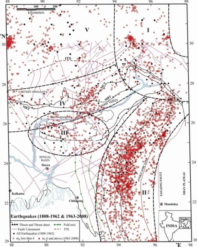 | Figure 2. Seismicity of Northeast India Himalaya and its adjoining regions from 1808 -2008 over the major tectonic features MCT, MBT, IBR, and Shillong plateau. Roman letters I to V indicate seismically active regions delineated in the present study |
4. Data Analysis
- Focal mechanism solutions are determined by using P-wave first motion directions data of short as well as long periods from the catalogue of the International Seismological Centre (ISC) bulletin for the earthquakes with magnitudes mb 4.7-6.1 occurred from 1964-2008 in northeast India Himalaya and its adjoining regions. P-wave velocity structure model of Bhattacharya et al.[2] for the region is used to estimate the angle of incidence at each seismological station. Data related to ray parameter is taken from P–wave table of Herrin et al.[11] and estimated the angle of incidence of the ray at each recording station. The first motion directions of P–wave were plotted on an equal area projection of the lower hemisphere using the estimated values of angle of incidence (i) at the azimuth (Az) of each seismological station. The orientations of the nodal planes and the direction of P (pressure), T (tension) and B (null) axes were determined by using Wulff’s stereographic projection net. The azimuth and the plunges of the P, T and B axes and the orientation of nodal planes were measured in degrees from the north and the horizontal, respectively. For all the solutions, a double couple source has been assumed for the interpretation of earthquake mechanism.To investigate the current geodynamic status and stress pattern in northeast India Himalaya and its adjoining regions considering 94 focal mechanism solutions (Fig. 3). And source parameters and focal mechanism solution parameters for these earthquakes are furnished in Table 1. The distribution of inferred faulting patterns from focal mechanism solution of these earthquakes, in relation to major tectonic features, is shown in Fig. 4 at their epicenter locations.
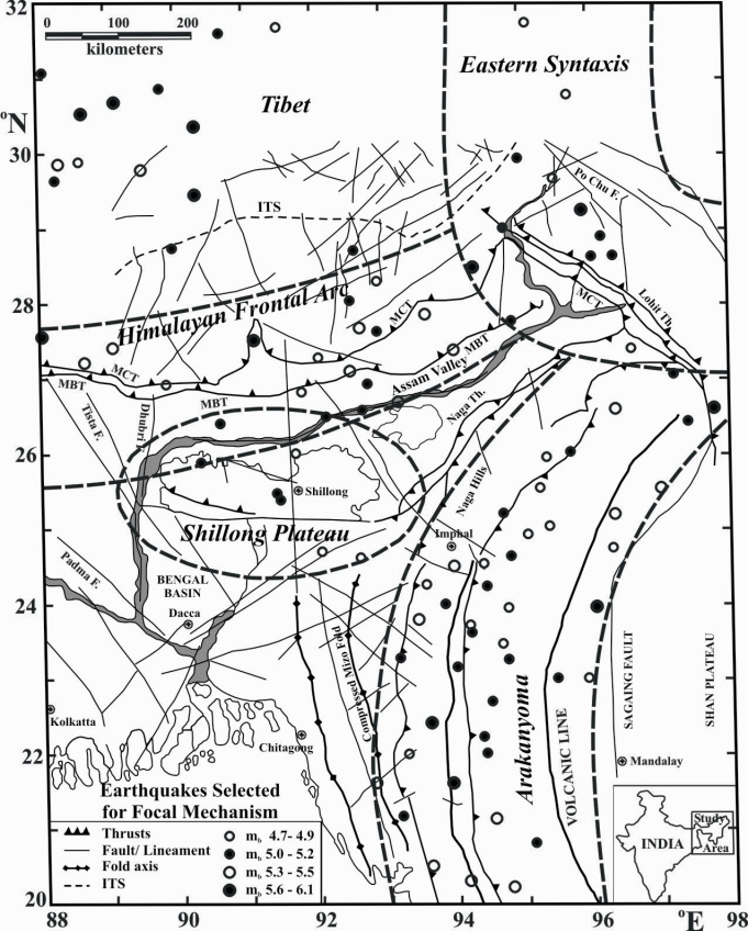 | Figure 3. Spatial distribution of ninety-four mainshocks occurred during 1963-2008 in Northeast India Himalaya and its adjoining Southeast Tibet region selected for focal mechanism solutions and seismotectonic studies |
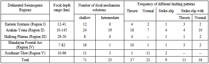
5. Statistic of Faulting Patterns
- The tectonics of Northeast India and its adjoining Eastern Himalaya, Southeastern Tibet and Burma regions is quite complex in which mixed faulting pattern is observed. It may be seen from Table 2. that the thrust environment is very much dominant in all the regions except Southeastern Tibet which is dominated by normal faulting. The tectonics of Arakan-yoma region is even more complex in which almost equal percentage of normal as well as thrust faulting occurs from shallow to intermediate depths. The nodal planes of thrust events orient predominantly in N to NE directions, and it is NW-SE to E-W direction of nodal planes for normal faulting events similar to that of the Southeastern Tibet. Thrust environment is predominant in Himalayan Frontal arc, Shillong plateau and Eastern Syntaxis regions but a few normal and strike-slip faulting have also occurred. The different tectonic regimes as observed from north to south are (1) extensional in Tibet region, (2) compression in Eastern Himalaya; and (3) both extensional and compressional in Arakan-yoma region to the south. The faulting pattern in the adjoining Tibet is totally different than Himalayan compression belt where normal faulting is predominant with north-south trending nodal planes leading to east-west flow of materials. The data furnished in Table 2 also suggest that most predominant mode of energy release in Eastern Himalaya is due to thrust faulting, and due to both normal as well as thrust faulting in Arakan-yoma regions, whereas mechanism for energy release in the Southeastern Tibet is solely due to normal faulting.
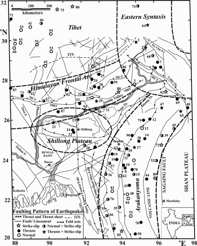 | Figure 4. Spatial distribution of faulting patterns of the ninety-four mainshocks occurred in Northeast India Himalaya and its adjoining regions during 1963-2008 |
6. Discussion and Conclusions
- It has already been established that the great Himalayan mountain range was formed as a result of the collision of two mega tectonic plates India and Eurasia. This collision, which happened some 65 million years ago, was brought about by the northward movement of the Indian plate that resulted in closing of the vast intervening Tethyan Ocean. Many scientists have already pointed out that collision of the Indian plate with the Eurasian plate, which occurred in the Late Tertiary[16, 21], is the sole cause for the faulting pattern being observed in the Himalaya and its adjoining region.
 | Table 1. List of ninety-four earthquakes occurred during 1963-2008 in northeast India Himalaya and its adjoining Tibet region are considered for seismotectonic studies using focal mechanism parameters derived through focal mechanism solutions of these earthquakes. Focal mechanism solutions for the first 34 mainshocks (Sl. No. 1-34) have been done in the present work, and the remaining 60 solutions (Sl. Nos. 35-94) and their source parameters are taken from different published literatures. The strikes, dips, dip directions (dip dir.) and slips of both the nodal planes; and azimuths (Az) and plunges (Pl) of P, T and B-axes for each of the mainshocks are estimated/ taken and these are furnished in degrees. Dip directions are considered for both of the nodal planes related to the first 34 mainshocks, whereas it is slip angle for the remaining 60 mainshocks |
ACKNOWLEDGEMENTS
- Author (DS) is thankful to Department of Earthquake Engineering for excellent computational facility. Authors (HNS and AP) are grateful to Prof V P Singh, Prof. U S Singh and Prof. M. Banarajee of Department of Geophysics, Banaras Hindu University Varanasi, India for their continuous encouragement to organizing the scientific knowledge. Authors are also thankful to learned referees and editor for their comments and suggestions which improved the manuscript appreciably.
References
| [1] | Acharyya, S. K., Geology and Tectonics of NE India, Jour. of Geophys., XXVI (1), 35-39, 2005. |
| [2] | Bhattacharya P. M., Mukhopadhyay, S., Majumdar, R. K., and Kayal, J. R., 3-D seismic structure of the northeast India region and its implications for local and regional tectonics, Jour. Asian Earth Sciences, 33, 25-41, 2008. |
| [3] | Chandra, U., Seismicity, earthquake mechanisms and tectonics along the Himalayan mountain range and vicinity, Phys. Earth Planet. Inter., 16, 109-131, 1978. |
| [4] | Chandra, U., Seismicity, earthquake mechanisms and tectonics of Burma, 20˚N- 28˚N, Geophys. J. R. Astron. Soc., 40, 367-381, 1975. |
| [5] | Chen, W. P., and Molnar, P., Source parameters of earthquakes and intraplate deformation beneath the Shillong plateau and the Northern Indoburman Ranges, J. Geophys. Res., 95, 12527-12552, 1990. |
| [6] | Chouhan, R. K. S., and Srivastava, V. K., Focal mechanism in northeastern India and their tectonic implications, Pure Appl. Geophy., 113, 467-482, 1975. |
| [7] | Deshikachar, S. V., A review of the tectonic and geological history of Eastern India in terms of ‘‘plate tectonics’’ theory, Jour. of Geol. Soc. India; 15, 137–49, 1974 |
| [8] | Dutta, T. K., Seismicity of Assam -zone of tectonic activities, Bull. NGRI, 2, 152-163, 1964. |
| [9] | Evans, P., The tectonic framework of Assam, Jour. Geol. Soc. Ind., 5, 80- 96, 1964. |
| [10] | Gupta, H. K., Rajendran, K., and Singh, H. N., Seismicity of North- East India region: Part I: The database, J. Geol. Soc. India 28, 345–365, 1986. |
| [11] | Herrin, E., Arnold, E. P., Bolt, B. A., Clawson, C. E., Engdahl, E. R., Freedman, H. W., Gordon, D. W., Hales, A. L.,. Lobdell, J. L., Nuttli, O., Romney, C., Taggart, J., and Tucker, W., Seismological tables for P- phases, Bull. Seismo. Soc. Am., 58, 1193–1241, 1968 |
| [12] | Kayal, J. R., Seismicity of northeast India and surroundings- Development over the past 100 years, J. Geophysics, 19, 9-34, 1998 |
| [13] | Khattri, K. N., and Tyagi, A. K., The transverse tectonic features in the Himalaya, Tectonophysics, 96, 19-29, 1983. |
| [14] | Le Fort, P., The Himalayan evolution, In: The Tectonic of Asia (Eds. A. Yin and T. M. Harrison), Cambridge University Press, New York, 95–109, 1996. |
| [15] | Molnar, P., and Chen, W. P., Focal depths and fault plane solutions of earthquakes under the Tibetan plateau, J. Geophys. Res., 88, 1180-1196, 1983. |
| [16] | Molnar, P., and Tapponnier, P., Active tectonics of Tibet, Jour. Geophysics, 83, 5361-5375, 1978. |
| [17] | Mukhopadhyay, M., and Dasgupta, S., Deep structure and tectonics of the Burmese arc: constraints from earthquake and gravity data, Tectonophysics, 149, 299–322, 1988. |
| [18] | Nandy, D. R., and Dasgupta, S., Seismotectonic domains of northeast India and adjacent areas, Phys. Chem. Earth, 18, 371-384, 1991. |
| [19] | Nandy, D. R., Geodynamics of Northeastern India and the adjoining region, ABC Publications, Calcutta, pp. 209, 2001. |
| [20] | Ni, James and Barazangi, M., Seismotectonics of the Himalayan collision zone: geometry of the underthrusting Indian plate beneath the Himalaya, Jour. Geophys. Res., 89, 1147-1163, 1984. |
| [21] | Powell, C. M., and Conaghan, P. J., Plate tectonics and the Himalayas, Earth Planet. Sci. Lett., 20, 1-12, 1973. |
| [22] | Rastogi, B. K., Singh, J., and Verma, R. K., Earthquake mechanisms and tectonics in the Assam- Burma region, Tectonophysics, 18, 355-366, 1973. |
| [23] | Shanker, D., Singh, H. N., Paudyal, H., Kumar, A., Panthi, A., and Singh, V. P., Searching for an Earthquake Precursor- A case study of precursory swarm as a real seismic pattern before Major Shocks, Pure and Appl. Geophys., 167, 655–666, 2010. |
| [24] | Singh, H. N., Shanker D., and Singh, V. P., Occurrence of anomalous seismic activity preceding large to great earthquakes in northeast India region with special reference to 06 August 1988, Phys. Earth and Planet. Inter., 148, 561-284, 2005 |
| [25] | Singh, V. P., and Shankar, D., On the seismicity and tectonic activity of Bengal Basin, Mausam, 43 (4), 371-378, 1992. |
| [26] | Tandon, A. N., and Srivastava, H. N., Fault plane solution as related to known geological faults in and near India, Ann. Di Geofis., 28, 13–27, 1975. |
| [27] | Verma, R. K., Mukhopadhyay, M., and Ahluwalia, M. S., Earthquake mechanisms and tectonic features of northern Burma, Tectonophysics, 32, 387-399, 1976. |