-
Paper Information
- Next Paper
- Paper Submission
-
Journal Information
- About This Journal
- Editorial Board
- Current Issue
- Archive
- Author Guidelines
- Contact Us
Geosciences
p-ISSN: 2163-1697 e-ISSN: 2163-1719
2013; 3(3): 77-88
doi:10.5923/j.geo.20130303.01
Depositional Evolutionand Sediment Facies Pattern of Upper Cretaceous in Zagros Basin, South of Iran
 Abstract
 Reference
 Full-Text PDF
 Full-text HTML
Sajjad Abbas Alinejad1, Payman Rezaee2, Alireza Piryaei3
1MSc Student at the University of Hormozgan, Department of Geology science, Bandar Abbas, Hormozgan, Iran
2Assistant professor at the University of Hormozgan, Department of Geology science, Bandar Abbas,Hormozgan, Iran
3NIOC Exploration Director, Department of Geology surface, Tehran, Iran
Correspondence to: Sajjad Abbas Alinejad, MSc Student at the University of Hormozgan, Department of Geology science, Bandar Abbas, Hormozgan, Iran.
| Email: |  |
Copyright © 2012 Scientific & Academic Publishing. All Rights Reserved.
The Upper Cretaceous (Campanian - Maastrichtian) units of Zagros fold-thrust belt were studied in four different regions (east khamir, west khamir, Namak and west Namak) in Hormozgan Province, Iran. Four cross-sections were constructed using well and outcrop data and illustrate facies and thickness variations within the Upper Cretaceous. Sedimentary environment and basin changes through the time of depositionofthese successions were studied. Based on the microfacies and by comparing the outcrops and wells, two depositional systems can be recognized in the Upper Cretaceous succession in the study area: intrashelf basin and pelagic-hemipelagic basin. Sediments deposited in intrashelf basin are dominated by thick to massive bedded limestone, Loftusia-bearing Packstone to Grainastone facies and index species of Loftusia give the age upper Maastrichtian. Pelagic basin Sedimentsfacies consist mainly thin to medium sized layers of gray marl and marlstone of wackestone to packstones with abundant pelagic foraminifera. Index species of Globotruncanagive the age of this sediment from Lower Companion to upper Maastrichtian. Rapid variations inthickness, Sequence stratigraphy and facies document the evolution of depositional processes in the foreland basin. In the study area, the foreland basin is characterized by a considerable SW to NE increase in stratigraphic thickness. The depocenter and related to maximum development of foreland basin of during this period of time was located in the SW as indicated by a thickness and facies.
Keywords: Upper Cretaceous, Foreland Basin, Depocenter, Hormozgaan Province
Cite this paper: Sajjad Abbas Alinejad, Payman Rezaee, Alireza Piryaei, Depositional Evolutionand Sediment Facies Pattern of Upper Cretaceous in Zagros Basin, South of Iran, Geosciences, Vol. 3 No. 3, 2013, pp. 77-88. doi: 10.5923/j.geo.20130303.01.
Article Outline
1. Introduction
- Organic belt, The Zagros is an 1800 km long mountain range extending NW-SE from the Taurus Mountains in NE Turkey[27,32] to the strait of Hormozin Iran[2]. The region is bounded by the Main Zagros Thrust zone to the north, the Zendan Fault to the east and SE and the Persian Gulf to the south. The Bandar Abbas region is a transitional area between three geological zones: The Zagros collisional belt to the NW, the Makran accretionary prism to the east, and the Oman Mountains to the SE (Fig. 1). The study area is located in the western and north part of the Bandar Abbas region (Hormozgan province). The most comprehensive work on the Mesozoic lithostratigraphic units of the Zagros was carried out by James & Wynd[13]. That study was linked to a study addressing biofacies nomenclature of Wynd [13]. Other more recent, stratigraphic studies include those of Kheradpir[17], Khalili[16], Setudehnia[28], Ghavidel- Syooki,[10]Taghavi et al., (2007). A biostratigraphic study of the Cretaceous in the Zagros area was recently carried out by van Buchem et al.,[33,34] and piryaei et al.,[24,25]. The Late Cretaceous interval exposed in the study area comprises two lithostratigraphic units (1) the Santonian to Maastrichtian Gurpi Formation; (2) the Maastrichtian, Tarbur Formation. The aim of this study is to provide a detailed overview of the sedimentary architecture of the Late Cretaceous succession in the Hormozgan Province using field studies combined with well data. This paper investigated depositional environment conditions and Evolution of Sedimentary Environments at the upper Cretaceous depositions based on study of microfacies in two section (west & east Khamir) and two well (Namak & west Namak) in Hormozgan province.
2. Materials and Methods
- The study area is located in the south-eastern Zagrosfold-thrust belt (Bandar Abbas area) (Fig. 1). It lies between the main Zagros thrust zone, the Kazerun Fault, the Razak Fault and the northern part of the Persian Gulf[3, 19]. This paper uses outcrop and well data from the onshore Bandar Abbas region. The Field data based on sedimentological and stratigraphical analyses were complemented by petrographical studies. Two outcrop sections were logged in the west and east Khamiranticline (Table 1; locations in Fig. 1). The outcrop sections have a total thickness of approximately 800 m, 400 samples were collected to thin-section analysis. Two wells in the Namak and west Namak anticline, which comprised of 450 m of sediments. The method used for this study comprises the detailed description of sedimentary features such as bedding Geometry, textures, lithological compositions, faunal content and special surface. It was used of two wells (Namak and west Namak, Fig. 1), for which gamma-ray, sonic and palaeontological logs were available. Palaeontological studies of foraminifera related to well successions were carried out in the Paleontological Department of the NIOC (National Iranian Oil Company). About outcrop sections, biostratigraphic analysis of foraminifers was carried out on thin sections or washed (HF acid-etched) samples and microfacies were named by Dunham method[5]. The palaeontological analysis of foraminifers, using the biozonation model proposed by Wynd[13]. The stratigraphic architecture of the Upper Cretaceous interval was reconstructed based on highresolution sedimentary sequence analysis. Sequencestratigraphic interpretations were done based on the methods and nomenclature used for shallow-water carbonate systems[33]. Finally, carbonate units microfacies and deposition environment were determined based on Flugel[8] facies belt. The outcrop sections were correlated with data of the wells and based on these data the evolution of sedimentary environments of Upper Cretaceous was analysed in this area.
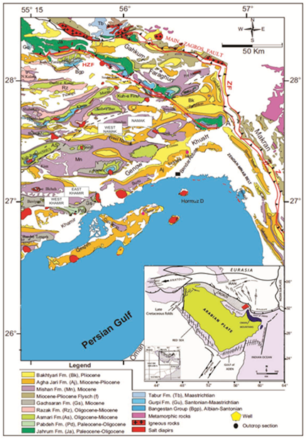 | Figure 1. Geological map of the Bandar Abbas area in Hormozgan province, southern Iran,Showing the locations of outcrop sections and wells(modified from Fakhari,[8] |
|
3. Results
- Two outcrop sections were logged at theKhamir anticline (east, west) and two wells (west Namak, Namak) are described in detailsthen compared with the logged sections (locations in Fig. 1).
3.1. East Khamir Section
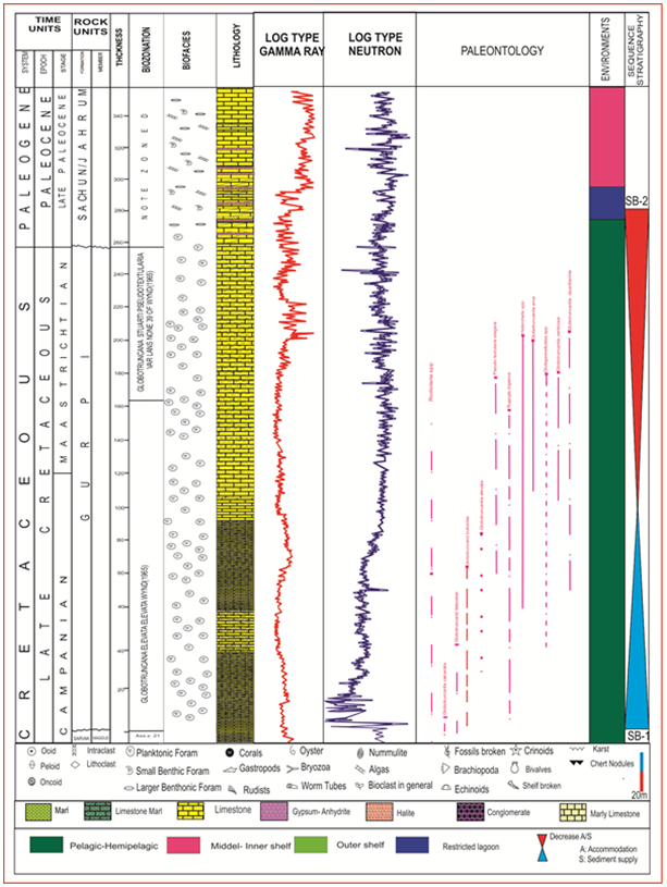
- The east Khamir section is located in a valley, situated3 km north of the Bandar-e-Pol city, in the eastern part of the southern flank of the Khamir Mountain. The exposed succession includes the Turonian to Santonian, Ilam Formation and the Santonian to Maastrichtian, Gurpi Formation[20]. Founded sediments within the southern and northern flankare representing which there are significant facies differences in the short distance(Fig. 2). This section is representative of the Late Cretaceous slope to central foreland basin setting[24, 31].Ilam FormationThe section starts with the upper part of the Ilam Formation (10 m), consist of thick-bedded to massive limestones, nodular bedded, Bioclastic wackestone to packstone which locally grades to Grainstone. Based on the faunal Archaecyclus mid-orientalis/Pseudedomiaassemblage a Turonian to Santonian age can be proposed for the Ilam sediments[13]. An iron-stained surface occurs towards the top of the basal nodular limestone unit with patches of rudist debris. This surface can be considered as theTuronian-Santonian unconformity[13]. Gurpi FormationThe Gurpi Formation reaches a thickness of 500 m and includes autochthonous facies. It can be subdivided into two units based on bedding pattern and sedimentary features (Fig 2). Unit A (10–420 m) consists of thin to medium bedded layers of gray marl and marlstone interbedded with thin layers of argillaceous limestone and marl. The interval contains three cycles; each cycle starts with marl and ends with marly limestone showing a pelagic facies. Based on this faunal assemblage the unit is attributed to the Globotruncana elevate elevate zone of Wynd[13], with a Lower Companian age and associated microfossils are G. bulloides, Hedbergella and Heterohelix.Unit B (420–500 m) consists of argillaceous lime stone interbedded with thinly bedded argillaceous limestone. Thin sections study of provided samples shows Faunal components include planktonic and benthic foraminiers, and pelagic facies with Globotruncana and Globigerina dominantly Bioclast wackestone–mudstone, Non-skeletal grains include pelloids[6]. Microfossils are dominantly planktonic (pelagic) foraminifera which showsbiozone: Globotruncana stuarti zone; associated microfossils are G. bulloides, G. Conica, G. Lapparenti, G. falsostuarti, Hedbergella and Heterohelix the age is Lower Maastrichtian [13]. Gurpi Formation in this section is located beneath the Pabdeh Formation. The Pabdeh Formation reaches a thickness of 620 m and includes autochthonous facies. base of Pabdeh Formationstarts with mediumto coarse-grained, monomict conglomerates and followed by Dark gray shale and marl with interlayers of thin bedded argillaceous limestones and alternative layers of gray thin to medium bedded argillaceous limestones, shale and marl at lower part which gradually change to medium to thick bedded limestones at middle and upper parts form the whole lithofacies of the formation.
3.2. West KhamirSection
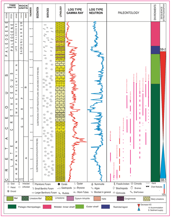
- The west Khamir section used in this study is positioned on the NW priceline of the anticline near the town of Khamir and lies with an east–west orientation. In these outcrops a continuous succession is exposed from upper Cretaceous to lower Tertiary units. The Ilam, Gurpi, and Tarbur Formations have been studied in great detail in this outcrop (Fig.3). Campanian and Maastrichtian deposits are best developed in this section. Ilam facies are very thin and consists of massive to thick-bedded limestones with a benthic fauna. Gurpi FormationThe Gurpi Formation is fully exposed; reaches a thickness of 300 m disconformably overlies Ilam Formation and consists thin bedded bluish gray marl and marlstone associated with thin interlayers of argillaceous light cream limestones. Occasionally, sparse silt and fine sand within the marl form salty and sandy marls at intervals. Partly increasing of these grains forms thin layers of shale. It can be subdivided into four subunits based on the faunal composition and sedimentary cycles. The section starts with several decimetre-scale beds of carbonate marlstone and thin to medium-bedded pelagic mudstone to wackestone with planktonic funa. Thin sections study of provided samples Based on the fauna of the Globotruncana ventricose concavata assemblage zone[13] a Santonian to Campanian age is attributed to the sediments. Within the Gurpi Formation occur several clast dominated decimeter to metre-scale beds that contain radiolarite elements such as chert and clastic sandstone rock fragments. A transition zone can be defined where interfingering is observed between the pelagic marls of the Gurpi Formation[15] and the rudist and benthic foraminifer-rich sediments derived from the nearby Tarbur formation.Tarbur FormationIn the main section the Tarbur Formation is thin and consists of (70 m) thick to massive bedded limestone. Formation starts with several metre-scale beds of limestone and sediments consist of packstone to floatstone with rudist and echinoderm debris, algae and benthic foraminifers (Rotalia, Dicyclina,Cuneolina, Loftusia). Based on the fauna of the Omphalocyclus–Loftusia assemblage zone[13] a Maastrichtian age is assigned to this formation( Fig 3). Tarbur Formation in this section has an interfingering relationship with pabdeh Formation. The Pabdeh Formation (470m) of this succession consists of thin tomedium bedded bluish graymarl and interlayers of argillaceous limestone. There are also some beds of purple to bluish shale with a thickness of about 3 moverlied by thin layers of nodular and lenticular chertand occasionally limestones interlayered with marl.
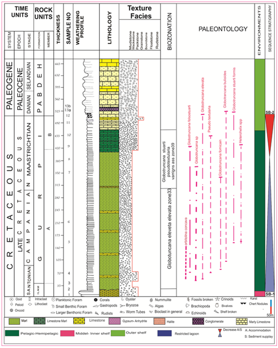 | Figure 2. East Khamirsection. Sedimentary and palaeontological log based on field data and microscopic observations |
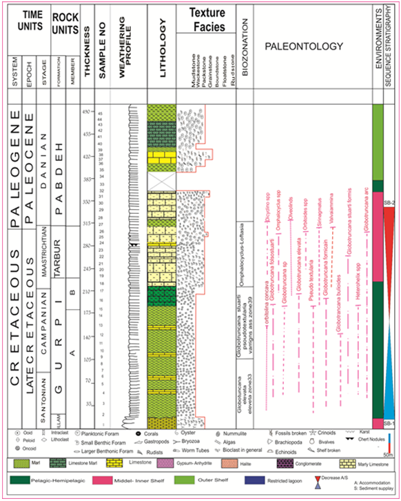 | Figure 3. West Khamirsection. Sedimentary and palaeontological log based on field data and microscopic observations |
3.3. West NamakWell
- The west Namak well is located in 65 km north of Bandar Abbas city, in the central part of the northern flank of the west Namak mountain front. Early Cretaceous to Late Oligocene sediments are continuously exposed in this well.The Late Cretaceous part of this succession consists of three main unit: a lower carbonate pelagic unit (Kazhdumi formation), the middle unit, which is attributed to the Sarvak Formation, that consists mostly of muddy, large benthic foraminifer-dominated, shallow-water facies (Mauddud Member), and an upper part, 240 m thick, consisting of pelagic basinal facies dominated by pelagic fauna (Gurpi Formation) (Fig. 4).
 | Figure 4. West Namak well. Sedimentary and palaeontological log based on microscopic observation |
 | Figure 5. Namak well. Sedimentary and palaeontological, gamma log based on and microscopic observations |
- Gurpi FormationOverall, Gurpi Formation has a maximum thickness approximately 250 m. At its base are 55 m of argillaceous mudstone to packstones containing Globotruncana, Hedbergella, Oligosteginids and Pseudotextularia. Based on this faunal assemblage the unit is attributed to the Globotruncana elevetaeleveta zone (33) of Wynd[13], with a Campanianage. The interval is overlain about 120 m of marls with elements of biozones 33 and 39 of Wynd[13] indicating a Campanian to Maastrichtian age.
3.4. NamakWell
- The Namak well are located in the core of the Namak anticline, approximately 75 km north of the city of Bandar Abbas (Fig. 1). The exposed well includes the Albian to Turonian, Kazhdumi and Sarvak Formations, the Santonian to Maastrichtian,Gurpi Formations (Fig. 5).Gurpi FormationThe interval is sedimentologically divided into two units, A and B (Fig. 3). The lower 50 m consists of thin to thick massive Globotruncana-Globigerina dominated pelagic faciesdeposits. Consist of decimetre-scale, nodular bedded, bioclastic wacke to mudstones which alternate with dark grey marly beds. The faunal assemblage includes G. bulloides, Hedbergella, Heterohelix and rare radiolaria. This unit is attributed to the Globotruncana elevetaeleveta biozone of Wynd[13] with a Campanian age.An iron-stained surface occurs towards the base of the basal nodular limestone unit with patches of glauconite. This surface can be considered as the Turonian-Campanian unconformity[13]. The upper part (Unit B) comprises sediments deposited in a Deep-water pelagic setting. deposits consist ofdecimetre-scale, shaly, dark bluish grey pelagic marls and shale’s with subordinate argillaceous limestones bedded, wackeston to mudstone containing Globotruncana and Hedbergella. Based on the faunal assemblage, this interval corresponds to the Globotruncanastuarti zone biozone of Wynd[13], and can be assigned to the Maastrichtian. The Gurpi Formation is locally overlain by approximately 300 m of cyclic evaporate and Limstones of the Suchun and Jahrum Formations.
4. Discussion
4.1. Interpretation of Depositional System
- Based on the microfacies and by comparing the outcrops and wells, two depositional systems can be recognized in the Upper Cretaceous succession in the study area: intrashelf basin and pelagic basin. This interval includes the Gurpi and Tarbur Formations (Fig. 3). Environments In the study have a wide variety of lithologies and sedimentary facies can be found. Based on lithology, sedimentary features and palaeontological analysis, two main lithofacies groups are distinguished: carbonate-dominated facies, and siliciclastic facies. They are presented below with their environmental interpretation. The stratigraphic relationships between these lithofacies are discussed in the biostratigraphic sections. Shallow-water sediments consist of packstone to Grainstone with rudist and echinoderm debris, algae and benthic foraminifers (Rotallia, Dicyclina, Cuneolina)[4,7]. These sediments were deposited in intra shelf basin (Tarbur formation)[33, 34]. Locally interbedding with facies bearing pelagic fauna (Heterohelix, oligosteginids) can be observed, which is interpreted as an deep basin environment (Hadavi, 2004). The Late Cretaceous carbonate sediments examined in this study represent an evolution from shallow water (intrashelf) to deep-water (pelagic) environments[6]. Because of the changing fauna and geometrical organization of the Late Cretaceous carbonate systems[1], they are presented in chronological order these sedimentary systems in each time interval can be related to a particular lithostratigraphic unit.
4.2. Deep Basin Pelagic Facies (Late Campanian– Early Masstrichtian)
- The pelagic basinalfacies were deposited in the deepest part of the basin during the Late Campanian–Early Masstrichtian (Gurpi Formation)[22]. The mudstones to packstones contain numerous types of planktonic foraminifers, such as Globigerinids and Globotruncanas, Oligosteginids and various rudist species. The bedding pattern varies from millimeters to decimeters scale (Figs.3, 4). In the khamir sections and wells (Namak, west Namak). In these locations the very thin-bedded marlyfacies is sometimes interbedded with medium wavy bedded limestone intervals. These mud-supported carbonate facies contain iron nodules, tar sands and a considerable amount of echinoderm fragments, which sometimes occur associated with condensed surfaces and Zoophycos ichnofossils. The Maastrichtian basinal facies is well developed in the east Kamir, and contains bioclastic wackestone to Packstone (Fig 6, 8). The faunal content of the basinal facies consists of a variety of planktonic foraminifers, radiolaria, oligosteginids and pelagic macrofossils in association with benthic elements reworked from the platform top. Compared with the underlying Campanian pelagic facies, the sediments show different decimeter - to meter-scale bedding patterns that alternate with marly intervals.
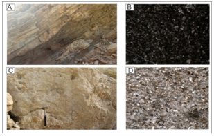 | Figure 6. Facies (A) and (C) illustrations of the Gurpi Formations deposits in the East Khamir area. Microphotographs of (B) Bioclastic Wackestonefacies (D) Intraclast Bioclastic packstone facies. 30x |
 | Figure 7. Facies (A) and (C) illustrations of the Gurpi formations deposits in the east Khamir. Microphotographs of (B) Bioclastic Mudstone facies (D) Bioclastic Wackestone facies. 30x |
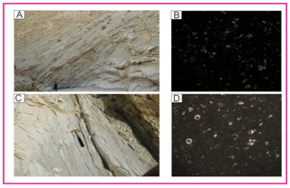
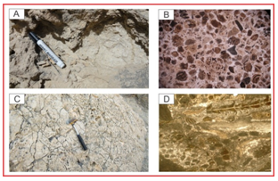 | Figure 8. Facies (A) and (C) illustrations of the Tarbur formations deposits in the Bandar-e-Khamir area. Microphotographs of (B) Intraclast Bioclastic Packstone facies (D) Bioclastic Grainstone facies. 30x |
4.3. Dominated Platform Carbonate(Maastrichtian)
- Several depositional environments can be distinguished in this depositional system, as follows[18]. (1) The inner platform facies is characterized by mudstones to packstones, with Orbitoides, milliolids, Dicyclina and non-skeletal grains such as pelloids. (2) The open platform facies consists of echinoid and rudist debris wackestone–packstone.(3) The thick packages of coarse-to very coarse grainedrudist-bearing limestone are interpreted as a high-energy barrier that occurred at the platform top. This facies is thick to massive bedded (meters scale), and shows considerable lateral and vertical Loftusia-dominated facies is developed in the west Khamir anticline. The Loftusiafacies contains both Loftusiapersica and Loftusiacoxi. Salinity and temperature are two important factors that control their distribution[18]. These large foraminifers are characteristic of an intrashelf environment[35]. They occur associated with rudist debris, Orbitoides, Siderolitescalcitrapoides and Omphalocyclus macroporus. The various species of Loftusia occur especially during the Maastrichtian in the west Khamir(Fig. 6).
4.4. Sequence Stratigraphy
- The Campanian-Maastrichtian interval is assigned to a single sequence. Sequence (1) is determined by the Campanian and Maastrichtian interval. These sequences can be correlated with those of Sharlandet al.[30] and van Buchemet al.[33] on the Arabian Plate. The basal sequence boundary (SB1) is characterized by a regional unconformity so that Namakwell on Aptian ramp system (DarianFm)[13], on the westNamak well at the top of shallowing-up and progradingorbitolinid-dominated Albian ramp system (Mauddud Member of the Sarvak Formation) and the Khamirsections(west and East) the lower boundary of the sequence (SB1) is located in a transition zone from platform carbonates (Ilam Formation). This unit can be traced throughout the study area and varies in thickness from 120 m in well Namakto 500 m in the east khamir section. In addition to the curtailment of other features can be found at this level karst topography, nodules of iron, iron oxide, in the context of succession of sedimentary, fossil and glauconitic. This level of change in wells sections is clear by logs of gamma ray and neutron. Thisis interpreted as a first order sequence (SB1), which begins from the base of the formation Gurpi studies, also the findings confirmed in Fars and Khuzestan[25,33].The maximum flooding surface (mfs) is marked by an interval bearing planktonic fauna or by a shift in the gamma-ray log as a result of an influx of shaly sediments in western Namak and Namak wells with layers of shaly limestone facies dominated by pelagic wackestone contains planktonic foraminifera such as Globotruncana (Globotruncana elevetaeleveta and Globotruncanasp) and the maximum shifting are gamma ray and neutron logs. In the western and eastern khamir sections this surface with a thin layer with cream of calcareous marl containing foraminifera pelagic mudstone facies dominated Wackestone and Globigerinids, Globotruncana.Transgressive systems tract (TST) is marked by shallow-water carbonate facies that are locally replaced by deep-water facies with planktonic foraminifera and calcispheres are representing intrashelf basin sedimentation. The part of the pelagic sediments contains pelagic foraminifera mudstone facies dominated by Globotruncana, Globigerinids arestartedlayers of limestone with thin layers of marl to shale. Khamir sections (west and east sections) are classified marly limestone with a thin layer of Campanian interval (Gurpi Formation) to begin on the place of Santonian carbonate platform (Ilam Formation).The highstand systems tract Facies (HST) is dominated by intrashelfplatform carbonates that sometimes show progradational geometries pelagic basin over the successions. This Namak and west Namak wellspelagic marl with thin layers deposited by evaporating the end of the dolomitic limestone layers containing algae intraclact Paleocene bentic foraminifera and Parts (Sachun formation) and ends up with a lower shifting of gamma ray and neutron lag are compatible. The east khamir section of the middle classes range between layers of limestone and marl (Gurpi formation), and foraminifera-bearing packstonefacies users pelagic and bottom contain components with non-skeletal benthic foraminifera known as pelloid and intraclactin the west khamir section of the upper part of the sequencepackstone to Grainstonefacies sediments of the middle layer contains Foraminiferal limestone packstone, components containing algae and Loftasia Maastrichtian age (Tarbur Fm.) continues.Age based on the sequence in this faunal assemblage is attributed to the zone 33 (Globotruncanaelevetaeleveta) of Wynd[13], with a Campanian age. This khamir (west and east) outcrop and wells (west Namak and Namak)with elements of biozones 33(Globotruncanaelevataelevata) and zone 39(Globotruncana Starti-Pseudotextulariavarian) of Wynd[13] indicating a Campanian to Maastrichtian age. In khamir sections, Based on the fauna of the assemblage zone 39 (Globotruncana Starti-Psoudotextularia)and assemblage zone 37(Omphalocyclus–Loftusia)[13]is restricted to the Maastrichtian age is on this formation.The upper boundary of the Cretaceous sequence overlay regional unconformity (SB2) which is present throughout the Zagros. in four sections are overlain by marly /dolomitic units of the Paleocene to Eocene pabdeh and Jahrum Formations or upper Paleocene to lower Eocene evaporates Sachun Formation. this placed as well as by changes in the pattern of layering, combined with lithology and changes in Fauna and microfacies is characterized by the type of first-order (SB-2) in the sediments of evaporate Sachun formation well with a major change in the gamma ray is determined. In East khamir section in the sequence (SB-1) conglomerate layers within the basin (containing rock fragments belong to Santonian(Ilam Formation) in the western section of chert nodules with intermediate layers of cream limestone and marl with pelagic Foraminiferalsuch as Globrotalia and Wackestone to packstone facies with fragments intraclast(PabdehFm).
4.5. Regional Cross-sections and Stratigraphic Evolution
- Four regional cross-sections were constructed through the wells and outcrops in the Bandar Abbas areas (profile locations are on Fig. 9). The characteristics from depositional history of this area can be divided into thickness and environments variations. These environments variations illustrate the transition from a shallow-water carbonate platform associated with anintrashelf basin, to development of a foreland basin in the study area[24]. During the Santonian (Ilam/Gurpi Formation), the sedimentary system consisted of shallowwater carbonate platform with associated pelagic facies. Platform deposits are characterised by Rotalia sp., algae, Archaeocyclus mid-orientalis and Pseudedomia, basinalfacies include Globotruncana and Globogerina.Khamirsections show that Santonian platform carbonates developed in the SW (IlamFormation), then wedge out in the central portion of the sections and grade into pelagic sediments in the NE (Kazhdumi and Maudud member of Sarvak Formations), suggesting flexure of the carbonate platform and erosion in the NE. The Santonian interval remained shallow-marine in the east khamirsection and was composed of shallow-water platform carbonates in the wells (west Namak and Namak). Campanian to Maastrichtian deposits occur throughout the study area and mainly comprise pelagic marls, frequently interbedded with marls and limestone deposits during the Campanian. In the, east Khamir and wells successions (late Maastrichtian) shows an overall shallowing trend as pelagic marls (Gurpi Formation) but in other hand on the west khamir, Loftusia-bearing (Tarbur Formation) shows the shallow-water carbonates and intra shelf basin.
4.6. Thickness Variations
- Thickness variations and associated facies transitions are evidence for this transition, while the change inregional-scale Environments led to considerable change in accommodation along a WSW-ENE trend. This is shown by significant increases in the thickness of Santonian to Maastrichtian sediments in the khamir, anticlines. The Santonian was associated with increased tilting of the continental platform, thus creating a foreland basin between the Arabian and Iranian plates[21,26]. Cross-sections shows illustrates the wedging-out of Santonian shallow-water carbonates from the Namak and west Namakwells, and then an abrupt thickness increase to a few hundredmetres consist basinal facies include Globotruncana and Globogerina of pelagic facies in the eastkhamir section (Fig. 9). By contrast, the Campanian to Maastrichtian interval shows a marked lateral increase in accommodation from the Khamir section in the SW to the depocentre of study located in the eastkhamir anticline as indicated by a thickness of 500 m. The Campanian and Maastrichtian interval presents an increase in accommodation in the SW and NE, with low accommodation in the NE (west Namak and Namak wells) suggesting salt activity[11,12]. cross-sectionWest Namak and Namakvery similar to khamir sections showing a trend of increasing accommodation from SW to NE. In this cross section, thickness variations indicate general deepening from the khamir anticlines (Fig. 9), consistent with the statigraphy profiles in Fig. 7. The figure illustrates an increase in thickness toward the SW, suggesting an increase inaccommodation space during foreland basin creation. East khamir section shows an anomalous thickness (500 m) with respect to nearby section (average 300 m), which could be related to maximum development of foreland basin during this period of time.
5. Conclusions
- Deposits of the Upper Cretaceous (Campanian – Maastrichtian) Gurpi and Tarbur formations on the Hormozgan Provincewere deposited in foreland basin system. Facies analysis indicates deposition ranging from intrashelf and basinal environments. In this region of folded zagros, Gurpi formations with Wackestone microfacies is related to pelagic environment and Tarbur formation with Packstone-Grainstonemicrofacies show shallow marine condition (intrashelf). By contrast, the Campanian to Maastrichtian interval shows a marked lateral increase in accommodation wedge-shaped deposits from the SW part of the study area. The depocentre of study located in the east khamir anticline as indicated by a thickness of 500 m.
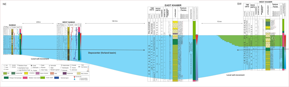 | Figure 8. Foreland basin profile: SW-NE cross-section through the west Khamir, east Khamir, Namak and west Namak sections showing facies and thickness variations in this study aria |