Fanan Ujoh1, James Ikyernum2, Olarewaju Oluseyi Ifatimehin3
1Department of Geography and Environmental Management, University of Abuja, FCT, Nigeria
2Department of Geography, Benue State University, Makurdi, Nigeria
3Department of Geography and Planning, Kogi State University, Anyigba, Nigeria
Correspondence to: Fanan Ujoh, Department of Geography and Environmental Management, University of Abuja, FCT, Nigeria.
| Email: |  |
Copyright © 2012 Scientific & Academic Publishing. All Rights Reserved.
Abstract
Reservoirs are Man’s attempt towards water re-distribution from regions/seasons of abundance/surplus to regions/seasons of scarcity. This study focuses on socio-environmental impacts of the Lower Usuma dam in Abuja, on its four surrounding communities. Stratified random sampling technique was employed in the administration of a questionnaire to 200 respondents. Using descriptive statistics and the student t-test for the analysis, the study discovered that: (i) there has been no significant improvement in infrastructure provision by Government; (ii) cases of water-borne diseases are high; (iii) the communities have lost land for cultivation; and, (iv) the communities believe that the resettlement scheme is not commensurate with their losses. It is recommended, thus: (i) the relocation scheme implemented for the four communities be reviewed with a view to improving the living conditions of the affected communities in terms of providing infrastructure (water and roads, educational and health facilities), and (ii) Strategic Environmental Assessment is encouraged for such projects.
Keywords:
Reservoir, Socio-environmental Impact, Sustainability, Usuma
Cite this paper:
Fanan Ujoh, James Ikyernum, Olarewaju Oluseyi Ifatimehin, "Socio-Environmental Considerations at the Usuma Reservoir in Abuja, Nigeria", Frontiers in Science, Vol. 2 No. 6, 2012, pp. 169-174. doi: 10.5923/j.fs.20120206.06.
1. Introduction
Water is very essential for the sustenance of life and for any meaningful development. The availability of this important resource has been the bedrock for the growth and flourishing of great civilizations and kingdoms since ancient times[1]. Presently, the availability of water in required quantity and quality is very important for the sustenance of population, more so as population and intensity of human activities increases much more than it had been in the past.Despite advances in drilling, irrigation and purification, the location, quality, quantity, ownership and control of potable water remains of important concern. This is in light of the fact that the earth’s total stock of water resources are hardly increasing, but water demand continues to increase due to population increase even in the face of surface and ground water pollution. This calls for urgent measures to ensure that water is not only made available for the various uses (agriculture/irrigation, domestic consumption,industrial and recreational usage) but is also utilized sustainably. According to[2], the supply of fresh water needed to sustain human populations became a major global concern in the latter half of the 20th century, bringing into focus questions about how best to manage this essential resource for presentand future generations.The rationale behind dam construction is therefore, to attempt a re-distribution of water from regions and seasons of abundance/surplus to regions and seasons of scarcity, as well as to appropriate it for other uses that require large volumes of water. This perhaps explains the unprecedented increase in the construction of large dams witnessed by the world in the latter half of the 20th century. According to[3], at the end of World War II, there were approximately 5,000 dams over 15 m high worldwide. By 1999 however, there were over 45,000 such structures, with a total estimated price tag of $2 trillion.However, several studies conducted in various regions of the world have indicated that Man’s attempts to re-engineer and manage the shrinking and uneven water resources distribution are in direct conflict with natural systems ([4],[5]). Reference[3] concluded that dams have significantly contributed to human development and the benefits derived from dams have been considerable. However, the socio-economic and environmental price has been unacceptably high. Resource management groups and scholars have therefore, begun to consider ways to reduce the socio-economic and environmental costs of dams. It is in this context that a third trend in water management emerged at the end of the century, which involves a thorough scrutiny of projects that require dam construction, for which in many cases, the costs seem to far outweigh the benefits[6].This study focuses on the investigating thesocio-economic and environmental effect of the Lower Usuma dam on the four immediate communities, about 20 years after it was constructed. Specific attention would be given to socio-economic gains and losses as well as environmental consequences among the communities of study.
2. Methodology
2.1. Study Area
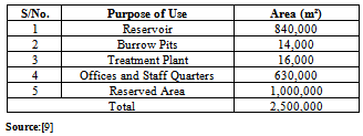
The Usuma dam is located on longitude 9º 01’ 12” N and latitude 7º 25’ 16” E. Sited 26 kilometers from Abuja city center (along the Dutse-Bwari road), and 10 kilometers away from Bwari, the dam is built across the River Usuma (Figure 1). The River Usuma, the second largest in the FCT after River Gurara, is a perennial stream with a relatively large network of tributaries. The Usuma drainage basin is the largest of the six drainage basins in the FCT, draining more than two-thirds of the FCT. It flows majestically through the Aso-Bwari hill ranges running across the north-eastern part of the FCT. The soils of are rich Alluvials and Luvisols. The vegetation is however, Park Savanna due to extensive human activities such as farming, hunting, tree-felling, etc.[7]. The original population of the four study communities is purely Gbagyi, a negative tribe that engages in farming, fishing and according to[8], collection of fuel-wood as a store of cultural value. At present, the population has become heterogeneous due to population expansion within the FCT. The Usuma dam has a reservoir capacity of 120 million m³ of raw, untreated water. The dam consists of two sides: the main dam and the saddle dam. The main dam embankment is 1.3 km long, 47m high and has a crest size of 10m. The saddle dam is 470m long, 15m high and has a crest size of 10m (see Plate 1). The total area used up by the dam is 2,500,000 m² (Table 1). The Usuma dam and the four communities (Payi, Jigo, Kwabwarra and Ushafa) constitute the area under the coverage of this study.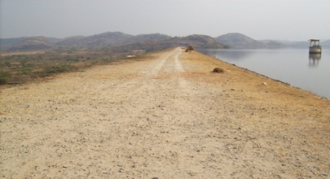 | Plate 1. The Lower Usuma Dam Crest |
Table 1. Land Allocation at Usuma Dam
 |
| |
|
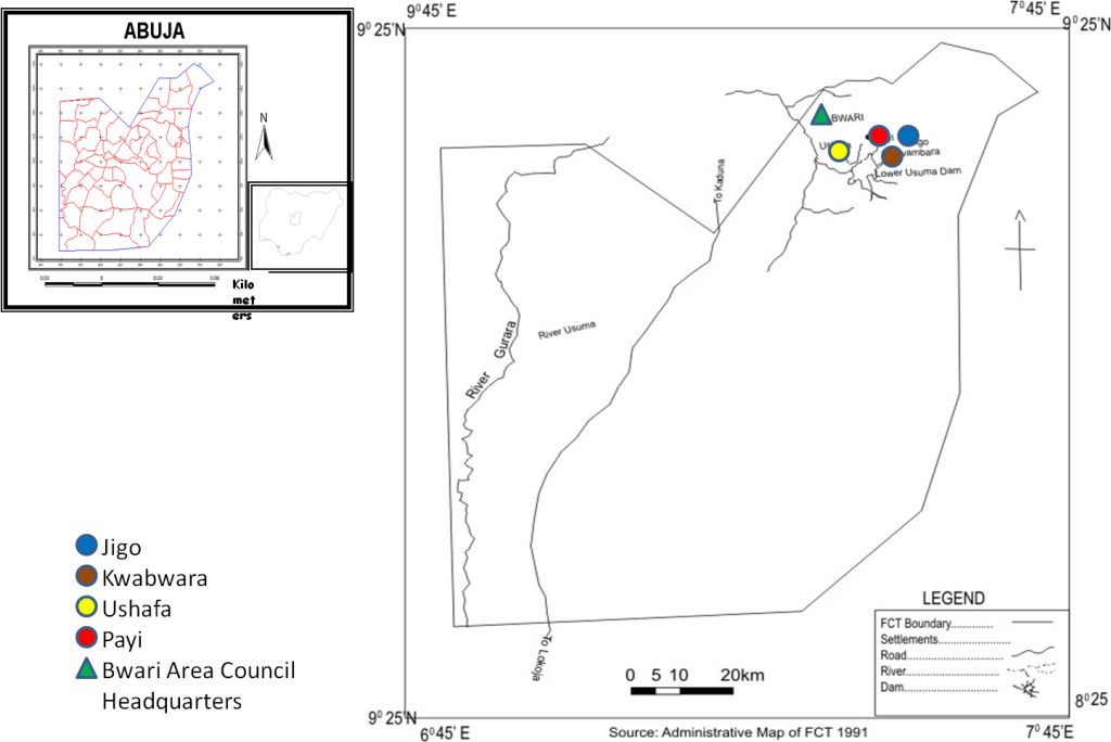 | Figure 1. Map of FCT showing the Usuma Dam and Study Communities |
2.2. Research Design, Sampling Technique and Questionnaire Administration
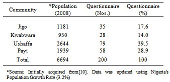
The study commenced with several reconnaissance/field surveys in order to familiarize with the area and to acquire information on both social and environmental aspects of interest to this study. A questionnaire was administered to adults of the indigenous Gbagyi population who represent the inhabitants of the surrounding communities of the dam. The questionnaire was divided into two main sections. The first part contained a total of nine questions aimed at collecting the personal data of the respondents which was used in providing background information of the respondents while the second part of the questionnaire contained a total of 12 questions which were designed to collect socio-environmental information from the respondents which was used as the primary data for the study. In all, the questionnaire was administered to 200 respondents using the stratified random sampling technique. This sampling technique had to be adopted due to the fact that these communities now shelter non-indigenes or settlers who are not officially recognized in the resettlement scheme, and therefore, do not constitute the population of interest to this study. In addition, upon identification, each respondent was administered the questionnaire orally in order to avoid the problems of poorly or wrongly completed questionnaire as a significant number of the respondents could neither read nor write.This was indeed hectic but fruitful as the return rate of administered questionnaires was 100%. The distribution of questionnaire among the 4 communities (Table 2) was based on the population size of the four communities under study. At each of the four communities, the services of a research assistant cum interpreter with very sound knowledge of the locality was employed during the process of questionnaire administration.Table 2. Questionnaire Distribution across the Study Communities
 |
| |
|
3. Results
3.1. Occupational Status of Respondents
Responses from the population of study revealed that the major occupation of the resettled population was (and is still) farming (Figure 2). Further inquiry revealed that the major crops that are cultivated include yam, maize, guinea-corn, sweet potatoes and vegetables while rice is cultivated at a much lower scale. Interestingly, before the dam was constructed there were no traders among the native population but this has changed as currently 18 respondents stated that their main occupation is now trading. The respondents also complained about traveling several kilometers to reach their farms, a situation that has only arisen due to the relocation from their ancestral/native settlements.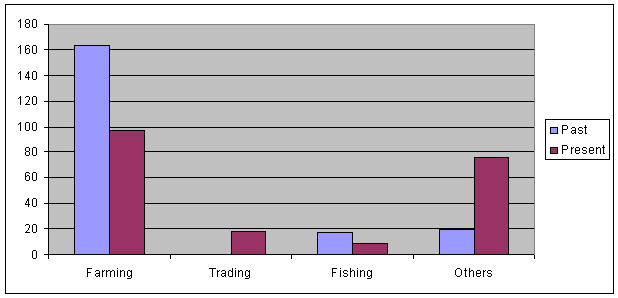 | Figure 2. ast and Present Occupation of the Respondents |
3.2. Educational Status of Respondents
The educational status of the respondents is shown in Figure 3. About 50% of the respondents are secondary school leavers, while only 9% attained tertiary education. The remaining population has either informal education (9%) or primary/elementary school certificate (21%). According to ([11],[12],[13]), education (literacy) is an index that is often incorporated in measuring the well-being and level of development of a population. Thus, the population of study is generally poor in its effort toward renewing and improving its future reservoir of skills and general abilities. The reason is not far-fetched as educational facilities within the study communities are grossly insufficient; only one public primary school and one secondary school are found located within the four communities. Also, scholarships and educational grants are not awarded to the displaced communities. This would have assisted them in acquiring formal education.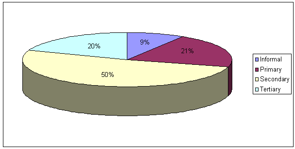 | Figure 3. Educational Status of Respondents |
The past and present income levels of the study population show that there are more people earning less than N50,000 presently than the period before the dam was constructed. Less people earn N50,000-N100,000 at present (Figure 4). However, more people are now found earning in the below N50,000 category than they were in the past, while less people now earn between N50,000 and N100,000. The people found in the above N100,000 category (although was previously low) has also reduced at present times. 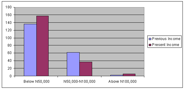 | Figure 4. Comparison of Previous and Present Income of Respondents |
3.3. Comparing Respondents’ Past and Present Income Levels
In this study, attention has been given to persons that fall within the income earning level of below N50,000. This is because[14] uses $1 (N150) per day (the equivalent of N50,000 per annum) as baseline for defining extreme poverty. Thus, there is a general tendency toward the lack/inadequacy of basic requirements such as calorie intake, health facilities, education, proper housing and transportation. This results to a very poor standard of living which invariably translates to poverty. This discovery tallies with an earlier study of the area carried out by[15].
3.4. Agricultural Land
About 186 respondents agreed that they did lost cultivable land to the dam project (Figure 5). Table 1 show that the amount of land lost to the dam area is 25 km2. The respondents also confirmed that they did lost land. However, the exact amount of land lost could not be ascertained from responses collated. Interestingly, residents of the Ushafa community seem to be less affected by the dam project as all of the responses regarding those who did not lost land came from the community.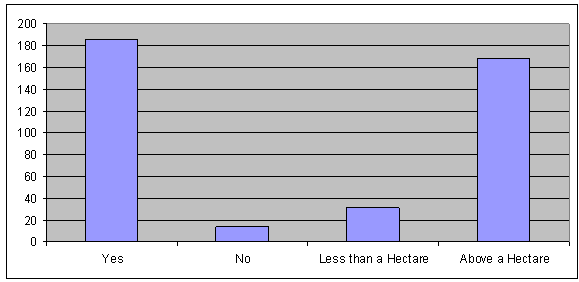 | Figure 5. Landloss to the Dam |
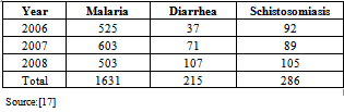
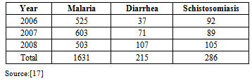
3.5. Water-Borne Diseases
The high incidence of water borne diseases suffered among the communities (Table 3) could be directly linked to the lack of available portable water for the communities. Majority of the respondents stated that there is no source of portable water provided the communities by government. Thus, they were utilizing water from the river, downstream of the dam. However, due to the prevalence of water-borne diseases, they had to resort to purchasing drinking water. The water-related diseases common among the communities are diarrhea, pruritus, guinea-worm, typhoid fever and malaria. This discovery also conforms to the findings of[16] where hospital records at the Lower Usuma dam revealed a large incidence of malaria and other water-borne diseases at the dam site.Table 3. Cases of Water-Borne Diseases at Study Area
 |
| |
|
3.6. Extensive Fuel-wood Harvest
The rate of fuel-wood harvest is shown to be very high among the Lower Usuma dam communities. Figure 6 reveal that 173 (or 86%) respondents actively participate in fuel-wood harvest for energy, commercial or cultural purposes (such as carving and stock-piling, etc.). Only 27 respondents (representing 14%) do not actively engage in fuel-wood harvest. The implication of this trend is in the fact that there is need for conservation around the area to ensure ecological restoration and stability if erosion and biodiversity loss is to be mitigated.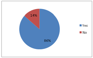 | Figure 6. Rate of Fuel-Wood Harvest within the Dam Communities |
3.7. Statistical Test
The student-t test was employed for data analysis. Five variables were tested. These include the level of adjustment of the resettled communities, incidence of water borne diseases, as well as adequate compensation that is commensurate to the losses they experienced due to the relocation to give way for the dam project. These form the key variables that were tested to ascertain the impact of the reservoir on the environment and the surrounding communities.The results of data analysis showed that the calculated t-value was 0.87 (Table 4). The table value of t at a significant level of 0.05 is 2.23. Since the table value of t is greater than the calculated t, it is concluded that the reservoir has impacted negatively on the socio-environment of the surrounding communities. In other words, the location of the reservoir is strongly accountable for the incidence of relatively high poverty levels among the dam communities, and water borne diseases such as cholera, typhoid, pruritus, malaria, etc., occurring among the surrounding communities.Table 4. Summary of Data Analysis
 |
| |
|
4. Discussions
The interpretation and implication of the results is that the dam has brought more negative consequences in terms of socio-environmental conditions of the four communities under-studied. The result is reduced farm produce, increased poverty levels, increased incidence of water-borne diseases, poor infrastructural base, etc. In view of the Federal Government’s effort toward ensuring that Nigeria becomes one of the top 20 world economies by the year 2020, and indeed, the provisions of the Millennium Development Goals (MDG) which aims at reducing extreme poverty among the developing nations by 2015, there is need for the responsible and relevant authorities to understand that the Resettlement Scheme executed for the four Usuma dam communities has not helped the communities. This is moreso as the Federal Government is also targeting to attain the status of Top-20 global economies by 2020. Although, the dam has not failed structurally, it has created very adverse ecological, socio-economic and environmental conditions that are today detrimental to the growth, progress and conducive living conditions of members of the four communities surrounding the dam. In fact, during the process of interview/data collation, it was gathered that the communities took the Federal Capital Development Authority (FCDA) to court a few years before, but the community lost the case in 2006. The FCDA is the government authority responsible for the physical and infrastructural development in the Federal Capital Territory. It was thus, in charge of the resettlement scheme that was put in place for the Usuma dam communities. The implication here is that the action of the four communities indicates that they are not satisfied with the resettlement package and have not adjusted to the effects of resettlement as contained in their package which was arranged for them by the FCDA. Lastly, the issues that have arisen from the resettlement of the study communities at Usuma dam site are indeed similar to those elsewhere in Nigeria where dams have been built. With the volume of land take and consequent dislocation of socio-cultural and economic activities by dam projects, there is the urgent need for an indepth review of the outright relocation model being applied for the resettlement of affected communities at project development areas across Nigeria. The direct impact on riparian biodiversity and other components of the ecosystem also requires that environmental audit be taken conducted at specified intervals to keep tabs on the status of host biodiversity with a view to serving as early warning systems and also prioritizing and ‘red-flagging’ areas of high impact requiring urgent mitigation.
5. Conclusions and Recommendations
This paper examined the socio-economic as well as the environmental impacts that the Lower Usuma reservoir have brought to bear on the surrounding communities. The findings have several implications both on the physical environment and on the communities affected by the dam. Environmentally, the area is now prone to water-borne diseases such as cholera, pruritus, typhoid, malaria, etc. The socio-economic implication of the findings on the communities is largely in the area of loss of occupation and income sources, which accounts for the generally poor standard of living (in terms of housing, food/calorie intake, availability of health and educational facilities, portable water, good road network, etc) among the communities. The occupational structure of the communities is now changing from being farmers and fishermen to traders, artisans and civil servants. This is due to the fact that fishing rights upstream have been restricted while agricultural land has shrinked since the construction of the dam and subsequent relocation of the communities. All of these affect the production and income generation capacities of the communities. For the sake of and sustainable development (as provided for by the UN Rio conference on sustainable development in 1992), the management of the Lower Usuma Reservoir should not just only work towards meeting the water needs of the present population of Abuja also avoid compromising the ability of future generations towards meeting their water needs. Such efforts would help avert unpleasant experiences such as the taking-up of arms and general insecurity that is now the case in the oil-rich Niger-Delta region and other parts of Nigeria.In light of the findings, the study recommends, thus:ⅰ The resettlement scheme that was earlier administered by the FCDA should be revisited. A more community-based, down-up approach should be adopted in revising the resettlement scheme;ⅱ Government should designate the area an ecologically fragile zone and should be placed under strict conservation;ⅲ Regular fumigation should be carried out at intervals within and around the vicinity of the four communities to curtail cases of malaria; and,ⅳ Basic infrastructure should be made available as a matter of urgency to the four communities. These include portable water, good road network, proper drainage system, electricity, as well as health and educational facilities.
ACKNOWLEDGEMENTS
The authors are grateful to the District Heads of the 4 study communities, Engr. Ajala of the Usuma Water Works as well as the interpreters and research assistants for aiding the process of data collection.
References
| [1] | Falkenmark, A. and Widstrand, D. ‘Population and Water Resources: A Delicate Balance’. In: Chup, C.D. “Dam Construction and Environmental Stability: Lessons from the Lower Usuma Dam in the FCT of Nigeria”. Journal of Social and Management Science. Vol. 9. pp 11-17, 1192. |
| [2] | Postel, S. Last Oasis: Facing Water Scarcity. W.W. Norton, New York, 1997. |
| [3] | World Commission on Dams (WCD). ‘Dams and Development: A New Framework for Decisions-Making’. Earthscan Publications, London, 2000. |
| [4] | Stott, R. and Smith, L. ‘River Recovery Project: Restoring Rivers and Streams through Dam Decommissioning and Modification’. Available On-line at http://en.wikipedia/dams/ 2001. |
| [5] | Tahmiscioglu,.M.S., Anul, N., Ekmeci, F. and Durmus, N. Positive and Negative Impacts of Dams on the Environment. Available On-line athttp://www.swissdams.ch/Committee/Dossiers/wcd/ICOLD%20Position%20paper.pdf, 2004. |
| [6] | Stanley, E.H. and Doyle, W.M. “Trading Off: The Ecological Effects of Dam Removal”. -22. Available On-line at http://www.frontiersinecology.org/, 2003. |
| [7] | Balogun, O. The Federal Capital Territory: A Geography of its Development. University Press, Ibadan, Nigeria, 2001 |
| [8] | Ologun, C.O. Environmental Impact of the Lower Usuma Dam. B.Sc. Research Project, Department of Geography, University of Abuja, Nigeria, 1998. |
| [9] | Chup C.D. “Dam Construction and Environmental Stability: Lessons from Lower Usuma Dam in the FCT of Nigeria”. Journal of Social and Management Science. Vol. 9. pp 11-17, 2002. |
| [10] | FCDA Task Force on Resettlement. In; Ologun, C.O.. Environmental Impact of the Lower Usuma Dam, 2008. B.Sc. Research Project, Department of Geography, University of Abuja, Nigeria, 1993 |
| [11] | Lloyd, P.E. and Dicken, P. ‘Location in Space: A Theoretical Approach to Economic Geography’. Harper and Row, New York, 1972 |
| [12] | Ozigi, A.O. and Ocho, L. ‘Education in Northern Nigeria’. George Allen and Unwin, London, 1981. |
| [13] | Balogun, O. ‘Diffusion of Post primary Schools in Kwara State’. The Abuja Journal of Economics and Social Studies, Vol. 30, No. 3, pp 335-349, 2001 |
| [14] | World Bank. “Poverty”. World Development Report. Oxford Press, UK, 1990. |
| [15] | Ujoh, F., Ojeamiren, O. and Kwabe, I.D. ‘Occupational Dislocation and Poverty Levels among the Usuma Dam Communities in Abuja, FCT’. Conference Paper, Faculty of Social Sciences National Conference, University of Maiduguri, Nigeria. 26-30 October, 2008. |
| [16] | Ujoh, F., and Ifatimehin, O.O. ‘Incidence of Malaria at Reservoir Sites: Lessons from the Lower Usuma Reservoir, Abuja-FCT’. African Journal of Modern Society, Vol. 2, No. 2, pp. 34-44, 2011. |
| [17] | Medical Records, Ushafa Primary Health Clinic, Ushafa, Abuja, Nigeria, 2008 |
 Abstract
 Reference
 Full-Text PDF
 Full-Text HTML