E. C. Merem 1, Y. A. Twumasi 2, J. Wesley 1, D. Olagbegi 1, M. Crisler 1, C. Romorno 1, M. Alsarari 1, P. Isokpehi 1, M. Alrefai 1, S. Ochai 3, E. Nwagboso 4, S. Fageir 5, S. Leggett 6
1Department of Urban and Regional Planning, Jackson State University, 101 Capitol Center, Jackson, MS, USA
2Department of Urban Forestry and Natural Resources, Southern University, Baton Rouge, LA, USA
3African Development Bank, AfDB, 101 BP 1387 Avenue Joseph Anoma, Abidjan, AB 1, Ivory Coast
4Department of Political Science, Jackson State University, 1400 John R. Lynch Street, Jackson, MS, USA
5Department of Criminal Justice and Sociology, Jackson State University, 1400 John R. Lynch Street, Jackson, MS, USA
6Department of Behavioral and Environmental Health, Jackson State University, 350 Woodrow Wilson, Jackson, MS, USA
Correspondence to: E. C. Merem , Department of Urban and Regional Planning, Jackson State University, 101 Capitol Center, Jackson, MS, USA.
| Email: |  |
Copyright © 2021 The Author(s). Published by Scientific & Academic Publishing.
This work is licensed under the Creative Commons Attribution International License (CC BY).
http://creativecommons.org/licenses/by/4.0/

Abstract
In the annals of Nigeria’s economic development, groundnut farming ranks high as a vital component of the nation’s prominence during the early days. Accordingly, groundnut sustained the economy at the federal and regional levels especially in the defunct Northern Nigeria through revenues generated from exports to local and foreign markets. The significance of the crop exemplifies common expressions associated with it like “groundnut pyramids” highlighting productivity and abundance of the produce. Under that scenario, in the economic imagination of the nation, groundnut farming flourished as a symbol of national wealth memorialized as iconic images in official stamps of the era and on warehouses awaiting exports with the crop stacked in bags mimicking the shape of pyramids. Such expressions deeply rooted in the fiscal policy and economic prowess in the Northern part of the country buttresses abundance of the crop in farm operations of the sector. Notwithstanding the overwhelming significance of the industry by the 1950s-1960s, the discovery and glut in oil and gas production resulted in the sudden decline of groundnut farming to the extent that, most peanut pyramids were turned into buildings instead of stacks of the produce. The other limiting factors consists of the volatility of the marketplace, changes in land use and output and other indicators located in the larger agricultural structure. Considering current initiatives to resurrect the production as part of economic diversification plans in Nigeria. Managers will benefit greatly from an in-depth assessment of the potentials and state of peanut farm activities in the North. At the same time, very little has been done in the literature to analyze the issue of groundnut production amidst decades of neglect. This enquiry will fill that void in the literature by assessing the state of groundnut farmland use under a mix scale method with focus on some selected states in Northern Nigeria. Emphasis is on the issues, trends, factors, impacts, resource analysis and efforts of institutions to sustain the sector. With results pointing to changes in land use and output over the years. The GIS mappings of the trends show gradual dispersal and expansion of groundnut producing activities into different portions of the North. Given some of the challenges and the factors that shaped changes under the rubric of socio-economic and physical forces. The paper provided recommendations ranging from education, effective land use regulation, the monitoring of groundnut farmland base, more lines of credit for farmers and the design of a groundnut farmland information system.
Keywords:
Groundnut farms, GIS, Northern Nigeria, Change, Factors, Impacts, Declines, Economy
Cite this paper: E. C. Merem , Y. A. Twumasi , J. Wesley , D. Olagbegi , M. Crisler , C. Romorno , M. Alsarari , P. Isokpehi , M. Alrefai , S. Ochai , E. Nwagboso , S. Fageir , S. Leggett , The Regional Assessment of Groundnut Farmland Use in Northern Nigeria, International Journal of Food Science and Nutrition Engineering, Vol. 11 No. 1, 2021, pp. 1-19. doi: 10.5923/j.food.20211101.01.
1. Introduction
In the annals of Nigeria’s economic development, groundnut farming ranks high as a vital component of the nation’s prominence during the early days. Accordingly, groundnut sustained the economy at the federal and regional levels especially in the defunct Northern Nigeria through revenues generated from exports to local and foreign markets. The significance of the crop exemplifies common expressions associated with it like “groundnut pyramids” highlighting productivity and abundance of the produce [1-8]. Nigeria currently produces about 2 million MT representing 5% of the world production. In the periods 1956 through 1967, groundnuts including its cake and oil, accounted for a chunck of Nigeria’s total export earnings with much of that from the Northern zone [9]. Being the 13th most important food crop of the world, peanut ranks highly as a major export crop for traders in the global marketplace. But there are concerns about aflatoxin level given the threats posed to the produce in Nigeria in the past, alongside drought and other elements [10,11,12]. While these worries are now receiving topmost attention in the sector via research and capacity building, the future for Northern Nigeria's groundnut as a food security catalyst and revenue source in the nation, remains far brighter than ever [13].Taking a cue from the histography of the crop, the production of groundnut in Nigeria started around 1912. In response to the nascent opportunities provided through high prices of the commodity at that time in the world. From then on, Nigeria emerged among the major producers with greater prominence between the 1950s-1960s and beyond. In the process, the nation took the lead as the largest producer and exporter of groundnut in the 1960s with output estimated at about 500,000MT yearly, until it reached the peak capacity of 1.6 million MT in 1973. Even as recently as the opening decades of the 21st century, Nigeria still stands as a major producer of groundnuts, accounting for 25 percent of world exports. Accordingly, in 2004 the country devoted about 3,500,000 hectares of land towards peanut cultivation coupled with production level of 2,750,000 tonnes [15,16]. Judging by the historical display of economic data in the nation, the crop at one time alone yielded 70% of Nigeria’s total export earnings prior to the oil boom [17]. In as much as groundnut sustained the economy through revenues generated from export transactions, the crop contributed to employment generation among rural farmers and the growth in processors in the North [18-22]. Under that scenario, in the economic imagination of the nation, groundnut farming flourished as a symbol of national wealth memorialized as iconic images in official stamps of the era and displayed for export destinations as pyramids [23,24]. Such expressions deeply rooted in the fiscal policy and regional economy in the Northern part of the country buttresses vast presence of the crop in farm operations of the sector. Also, peanuts are important in the confectionary trade among the rural traders and the oil from groundnut is sought after by the food and catering industries given its smoke point of 229.40c compared to soya oil. Despite the overwhelming significance of the industry in the 1950s and 1960s, as mentioned earlier, the discovery and glut in oil and gas production resulted in sudden declines and negligence of groundnut farming. In view of that, production fell by almost half in 1973 in less than a decade due to a combination of two important factors [25]. Essentially, the drought of 1974/75 prompted aphid infestation that destroyed over 000’000 of thousands of hectares of groundnut fields. While this led to huge losses to both farmers and traders together with the oil boom in the nation during the same period time. The loss from groundnut and the incessant flow of oil cash transformed peanut merchants to state contractors. With such a policy shift from agriculture to the oil industry, the drop in oil prices in the 1980s reduced government revenues and forced the nation to adopt stringent measures like Structural Adjustment Program (SAP) which eventually dismantled peanut marketing boards. While this left farmers without assured markets to hang on to. They were forced to adapt by embracing different strategies to cope with the situation. This entailed the shift from groundnut to other crops [26]. The other limiting factors consists of the volatility of the marketplace, changes in land use and output and other indicators located in the larger agricultural structure of Northern Nigeria. Even though such fiscal setbacks affected production of the crop, recent evidence shows, groundnut in Nigeria is mounting a come back again through current policy turnaround and the surge among Northern Nigeria's producing states in the Middle Belt and Kano state. Considering current initiatives to resurrect production as part of economic diversification plans of the Federal government [27,28,29]. Managers will benefit immensely from an in-depth assessment of the potentials and the state of groundnut farm activities in the Northern region. At the same time, very little has been done in the literature to analyze the issue of groundnut production amidst decades of neglect. This enquiry will fill that void in the literature by assessing the state of groundnut farmland use under a mix scale method of Geographic Information System (GIS) and descriptive statistics with focus on some selected states in Northern Nigeria [30,31,32]. With the emphasis on the issues, trends, factors, impacts, resource analysis and efforts of institutions to sustain the sector. The paper has five objectives and sections. The first two objectives delve on the analysis of recent issues in groundnut farmland use and to evaluate the production trends in Northern Nigeria. The third and fourth aims strives to assess the potentials of peanut farming within the various states and identification of the factors, impacts, and current efforts. The last and fifth objectives is to develop a decision support tool for planners.
2. Methods and Materials
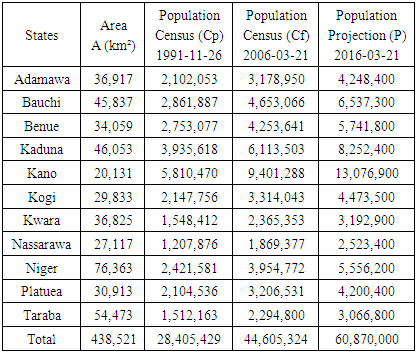
The peanut belt mainly in the Northern parts of Nigeria especially Kano, appears to have a Middle Belt dominance of some kind along the North central. All in all, the study area consists of 11 groundnut producing states from Kano, Kogi, Kwara, Nassarawa, Niger, Plateau to Benue (Figure 1). Located in the largely Middle Belt zone along Central Nigeria under the savannah ecozone with major Rivers of Benue and Niger nearby. The groundnut zone which stretches through a land area of 438,521 km² from the upper North to central Nigeria, had a population of over 60 million in 2016 (Table 1). As one of the most valuable legume crops of Nigeria and other tropical nations with 25 percent protein and more than 40% oil. Groundnut output nationwide accounts for 3.2% of fertilizer use and 6.1% of the entire cropland area [33].Table 1. The Population and Size of Northern Nigeria
 |
| |
|
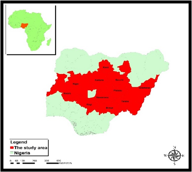 | Figure 1. The Study Area Northern Nigeria |
Obviously, groundnut as a farm produce, originally came from South America. Accordingly, it is among the most popular universal crops cultivated in more than 100 countries in six continents including the study area in Northern Nigeria, West Africa. The crop thrives under many different conditions, between 40° North and 40° South and matures from 100 – 140 days depending on the species. Surely, Nigeria’s peanut hub sits on a very diverse ecozone where production activities flourish under natural conditions suitable in the savannahs of various types made up of derived, South Guinea, Sudan, and Northern Guinea with the major farm fields stretched from the Middle Belt states to Kano in the far north [34-38]. In the study area, apart from being consumed raw, edible groundnuts are processed into many local foods in a wide range of other products which includes groundnut paste which is fried to obtain salted peanut cake. Given the rising needs, the demand for groundnut surged in Europe over time under a major shift from oilseed to the edible portions. This shift from oil to edible groundnut, led to stringent quality control measure of maximum permissible level of Aflatoxin B1 at 2μg/kg. In addition to the change in taste, groundnut production is also affected by serious competitions from other oil seed crops as the EU demands for peanut oil from West Africa fell by 200,000 MT per year in 1983 to a mere 5,000 MT yearly currently. With the discovery of oil, Nigeria’s exports of shelled groundnuts fell by 502,000 MT in 1961 to 291,000 MT in 1970 [39]. Considering the implications of the changes in peanut farmland use and output in Nigeria’s Northern region, the Federal government left no one in doubt by the series of measures initiated to revamp the sector in ways likely to benefit production activities in the years ahead. With the strengthening of production based on the study area’s average population growth rate of over 100% all through 2009 to 2016. The zone’s current potentials in groundnut farming although much more different form the levels attained during the Mid-20th century (1950s and 1960s) remains overly promising in lieu of the current policy directions of the Federal Government of Nigeria. This stems from the increments or changes in the core groundnut farm indices between the periods 2006-2010 in terms of the size of land areas devoted to cultivation and the volume of output estimated in thousands of hectares and thousands of metric tons [40,41]. Since this is essential as the study area and the nation gear up for a return to prominence entrenched in the heydays. The temporal-spatial distribution of much of the peanut’s farm indices most notably cultivation and productivity therein, affirms the dominance of the zone. Given the array of factors at work, there is ample opportunity to gain deeper insights on sustainable land use and food security systems of the zone in the enquiry by undertaking an assessment of the state of the peanut farming.
2.1. Methods Used
The research uses a mix scale approach involving descriptive statistics and secondary data connected to GIS to assess the state of groundout production and uses and the issues involved along Nigeria’s Northern region in West Africa. The spatial information for the study came through many agencies comprising of the National Population Commission of Nigeria, the Federal Ministry of Agriculture of Nigeria, the United Nations Economic Commission for Africa (UNECA), the United States Department of Agriculture (USDA) foreign agricultural services, and the USDA office of global analysis. Additional sources of geographic info are International Production Division, the University of Texas Libraries, The University of Texas at Austin, finileb, The United States Agency for International Development (USAID), CIA, Fesnet and GIS Department of E-West Africa. Other aspects of spatial data came from the Nigerian Meteorological Agency, the office of the Surveyor General, the Federal Government of Nigeria, International Institute of Tropical Agriculture (IITA), UN Food and Agricultural Organization (FAO), the United Nations Environment Programme (UNEP), and the International Union for the Conservation of Nature (IUCN). Additionally, the Governments of Northern region, the archives of the Federation of Nigeria in the First Republic and the European Union, the Economic Community of West African States (ECOWAS), the National Agricultural Seeds Council, the Bill and Melinda Gates Foundation, Institute for Agricultural Research/Ahmadu Bello University, Zaria; Centre for Dryland Agriculture/Bayero University of Kano; National Agricultural Seeds Council (NASC) and the Federal University of Agriculture, Makurdi also furnished other information needed in the research. Principally, much of the groundnut farm secondary data such as the area cultivated, cropland, the volume of peanut production, farm gate prices, agro-chemicals, fungicides, pesticides, herbicides, the percentage of changes, costs of seed / seedlings of groundnut, farm gate price by crop and state, quantity, cost, and the average price of fertilizer by state were obtained from both national and state government archives of the defunct Northern regions of Nigeria, the National Bureau of Statistics, Nigeria Data Portal, and Mundi Index and Knoema. While the World Bank, the agricultural and data base of the United Nation (FAOSTAT) and finelib provided background info and history, proportion of production among the states; the International Crops Research Institute for the Semi-Arid Tropics (ICRISAT) shared data on new improved high-yielding varieties. Added to that, the Foraminifera Market Research and USAID assisted in historical data on national output and outputs, and they provided the extra secondary data on the numbers, quantities, and the trends.Concerning the other sets of data, the groundnut markets in the North, farmers weekly, the National Groundnut Producers, Processors and Marketers Association of Nigeria (NGROPPMAN), National population commission, and All Farmers Association of Nigeria (AFAN), were individually essential in the procurement of information germane to the analysis on the various themes like areas cultivated, the volume produced and highlights of the changes. In a similar vein, the Central Bank of Nigeria (CBN), the African Groundnut Council, Chatham House, Green Sahel Agricultural and Rural Development Initiative; Catholic Relief Service, and the Peanut institute remained instrumental in the provision of other relevant information on the ranking of output. Give that the boundaries stayed the same and unchanged, the regional, state, city and federal geographic identifier codes of the states were used to geo-code the info contained in the data sets. This information was processed and analyzed with basic descriptive statistics, and GIS with attention to the temporal-spatial trends at the state and regional levels in Nigeria’s Northern region. The relevant procedures consist of two stages listed below.
2.2. Stage 1: Identification of Variables, Data Gathering and Study Design
The initial part in this study commenced with the identification of variables required to assess the scale of groundnut production as well as the trends at the regional and state levels from 2000, 2006 to 2012. The variables cover socio-economic and environmental data made up of population, population change rate, indices of peanuts, national groundnut output, groundnut cake, groundnut oil and soya oil, groundnut seed, groundnut sludge, prices, quantities, groundnut land area, percentage of output, temperature, groundnut yield, state groundnut production, harvested Area, local and global ranking of groundnut output. The others consist of peanut producing nations, population, area planted (thousand hectares) and production by crop, costs of seed/seedlings of groundnut, farm gate prices for groundnut by state, the quantity, and costs. Added to that are the average price of fertilizer by state, the volume and cost, distribution of farm agrochemicals, the quantity, and prices, coupled with insecticides, fungicides, herbicides, and the various percentages of change on variables. These variables as mentioned earlier were derived from secondary sources made up of government documents, newsletters, and other documents from NGOs. This process was followed by the design of data matrices for socio-economic and land use (environmental) variables covering the census periods from 2000, 2006-2008, 2009 to 2010 to 2012. The design of spatial data for the GIS analysis required the delineation of city boundary lines within the study area as well. Given that the official boundary lines between the 11 states remained the same, a common geographic identifier code was assigned to each of the area units for analytical coherency.
2.3. Stage 2: Step 2: Data Analysis and GIS Mapping
In the second stage, descriptive statistics and spatial analysis were employed to transform the original socio-economic and ecological data into relative measures (percentages, ratios, and rates). This procedure created the parameters for showing the extent of peanut production, cultivated area, land use change, land lost from planting, ranking of output, volume of chemicals applied, harvested areas and the price of fertilizers, the farm gate prices and changes in groundnut crop indicators driven by mounting usage and population upsurges and growth rates across the study area among the individual states through measurement and comparisons during the years. While the spatial units of analysis consist of various states, region, districts and the boundary and locations where the cultivation, consumption and delivery of groundnut flourished. This approach allows for the detection of change and the extent of usage. As the graphics highlight the actual frequency, impacts, groundnut land gains, declines, the rate of production, the trends, as well as the ecological and economic costs. The remaining steps involve spatial analysis and output (maps-tables-text) covering the study period, using Arc GIS 10.4 and SPSS 20.0. With spatial units of analysis covered in the eleven states (Figure 1), the study area map indicates boundary limits of the units and their geographic locations. The outputs for each state in the region were not only mapped and compared across time, but the geographic data for the units which covered boundaries, also includes ecological data of land cover files and paper and digital maps from 2000-2012. This process helped show the spatial evolution critical in locating various levels of use, and the trends, the ensuing socio-economic and environmental impacts, risks from ecological degradation, changes in other variables and factors driving groundnut production capacity, peanut land use and their effects in the region.
3. The Results
This part of the research centers on temporal and spatial analysis of peanut landuse activities in the study area. There is an opening focus in the analysis of land usage and groundnut production in the study area at the regional and state levels based on the operation of big, medium, and small producers using descriptive statistics. The other sections present the percentage composition and distribution of both land use and peanut output over different periods coupled with an assessment of the accumulated impacts on Nigeria’s Northern region. This is followed by the remaining portions consisting of GIS mappings, and the identification of factors responsible for the changes in Northern region’s groundnut cultivation operations and the efforts of various stakeholders in the zone.
3.1. Regional Land Use and Production 2006-2012
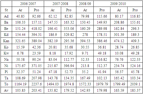
In the context of groundnut farming in the group of Northern states of mostly middle Belt extraction. The region saw big activities in output and the land areas planted with the produce all through 2006 to 2012. The zone planted 1164.19 hectares to produce 2237.6 TMT (thousand metric tons) on farm fields with volumes of output at relative average levels of 105.83 ha to 203.41 TMT. These are indicative of the intense level of operations in the entire study area during fiscal years 2006/2007. With time in the following periods 2007 to 2008 and 2009-2010, note that the core peanut farm indices for the region went from 1494.03 ha to 1974.8 TMT and continued at 1572.33 ha-1979.79 TMT, respectively. Further along that pace in other years (2009 -2010 to 2010-2011), the land coverage and production for groundnut stood at 1799.49 ha to 2039.1 TMT together with 1849.5 ha -2536.89 TMT in the ensuing periods. Notwithstanding the region’s slightly identical averages in both groundnut farmland areas and output proportions over the years, a much closer look at the emergent trends shows a gradual surge even though it seemed a bit different from the levels in the previous years. Thus, beginning in 2007/2008 to 2008/2009, the mean values for the size of land set aside for groundnut farms and the quantity produced at the regional levels held firm at 135.82 ha -179.52 TMT and 142.93 ha-179.98 TMT. In following that pattern, by the 2009/2010 to 2010/2011 fiscal years, the region’s major peanut land use indicators jumped from 163.59 ha-185.37 TMT to 168.13 ha-230.62 TMT respectively (Table 2-Table 2.1).
3.1.1. Groundnut Production Areas In the Big States
The peanut index indicates the dominance over farmland area and crop volume appears skewed especially towards a trio of places like Kano in the far North and the group of other Middle Belt states such as Niger and Kaduna. In as much as among these states, Kano held bigger land areas for groundnuts measured at 321.65 ha to 382.19 ha compared to 175.67 ha and 215.87 ha for Niger state between 2006/2007 and 2007/2008. The second tier of states (Benue, Bauchi, and Taraba) followed up, while the low-level producers which are also worthy of mention remained active, largely along the other central Nigeria states in the groundnut belt of the North from Kogi to Plateau. From the matrix, the initial groundnut production levels for Kano which began at 389.04 TMT-295.36 TMT to 386.46 TMT between the fiscal years 2006 to 2009 faded. It all started as Niger state’s output at 396.94 TMT, 512.37 to 524.16 TMT gained visible steam all through 2007/2008 to 2008/2009 with increments at levels that surpassed every state. In the process, the production increases for Niger state also extended further deep onto 2009/2010 to 2010/2011 at much higher levels of 546.62 TMT. Kaduna state on its part had strong opening values with some variabilities in peanut land and output in the first two years (2006/2007 and 2007/2008) in the order of 154.44 ha-394.31 TMT to 186.9 ha-329.82 TMT. With Kaduna having outpaced Kano and Niger in production values in 2006/2007, it remained active in farm operations again in 2008/2009 to 2009/2010 when its peanut farmland size moved from 278 ha, 301.39 ha to 235.65 ha. Consistent with Kaduna’s role as one of the leading states in groundnut farming are the growing pace of output values of 178.51 TMT, 189.3 to 297.51 TMT in three different periods from 2008 to 2011 (Table 2-Table 2.1).
3.1.2. Land Areas and Output Among Other States
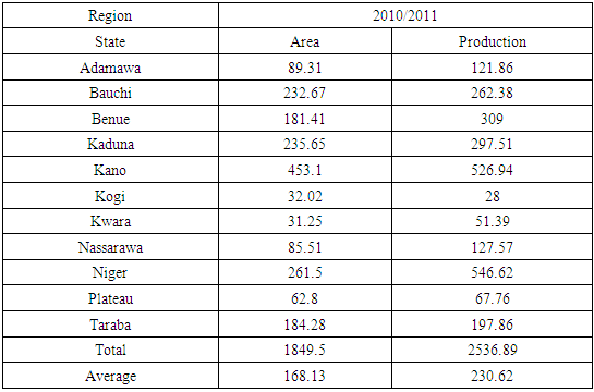
Of the medium tier group of states, aside from some level of fluctuations, groundnut farming in Benue epitomizes a place where peanut land use through planting and production appeared in sync with the patterns witnessed in the upper tier states earlier. Surely, the state still stood out among the neighboring areas through the large swaths of groundnut fields under cultivation in a span of five years. To buttress the activities in the area during those periods, Benue’s groundnut land base posted impressive opening figures of 151.24-196.41 ha coupled with another batch of areas estimated at 160.29 -162.84ha and covered with crops by the fourth period. Under that level, the planting of groundnut which went unabated in the fifth year reached the second highest level of 181.41 ha throughout the entire times under analysis. The breakdown of the figures pertaining to the temporal distribution of production for Benue were at an all-time high for such a lower tier state with 418.02-353.06 TMT to 289.98- 296.3TMT and 309 TMT from 2006 to 2011. Furthermore, Bauchi which saw its cultivated groundnut land area grow from 106.33ha to 147.55 ha by 2006 to 2008, held additional areas (150.45-208.86 ha, and 232.67 ha) devoted to the crop in 2009 and 2010 through 2011. The same thing can be said of the appreciable production quantities of 157.11-163.32 TMT and 149.93 -155.61 TMT to 262.38 TMT for groundnut in the state during the timeline of 2006 through 2011. In the case of Taraba, both planted areas and output capacity fluctuated visibly by 108.69 ha to 207.98 TMT in the first periods of 2006/2007 and continued in the ensuing years with 143.78ha to 134.35 TMT in the core farm indices by the later years. Taraba state stayed active in farm activities as both cultivated areas and production maintained identical values of 167.49 ha to 102.13 TMT and 165.42ha -103.34 TMT until an uptick of 184.28 ha to197.86 TMT by 2010/2011 (Table 2-Table 2.1).Table 2. Ground Nut Areas Planted in thousand Hectares and Production in TMT
 |
| |
|
Table 2.1. Ground Nut Areas Planted in thousand Hectares and Production in TMT
 |
| |
|
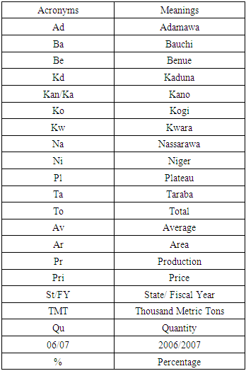
The quintet of the lower tier groundnut farming states (Adamawa, Nassarawa, Plateau, Kogi and Kwara) as contained in the Table within the middle belt zone regardless of their ranking exuded formidable viability as future areas to expand the crop’s appeal. Having said that, these areas are relevant also in the analysis and future projections of the crop in the region. Among the lower tier states, Nassarawa as the leading producer accounted for enough groundnut farmland areas (valued at 50.58 to 83.04 ha to 52.33ha 76.76 ha, and -85.51ha) therein between 2006 through 2011. Such remarkable level of coverage in land base all those years did spark a rally that drove up the state’s initial groundnut crop production volumes of 90.24 TMT-112.77 to 116.82, 122.33-127.57 TMT. Adamawa state on the other end, saw opening peanut land areas of 40.85 ha to 62.12 ha. This initial profile eventually varied by 79.98ha, 80.17ha to 89.31 ha, alongside the state’s output levels of 92.66-82.85 TMT to 115.66 and others at 116.85 to 121.86 TMT in the same periods as well. Of great relevance to the markets and the consumption of the produce are the farm activities in the three remaining states of Kogi, Kwara and Plateau. While Plateau’s groundnut farm activities involved a much more lower land base set aside in different phases of 32.37 ha - 47.18 and 35.2-56.37ha to 62.8 ha. The production sequence was quite steady as the proportions went from similar levels of 51.24 TMT, 52.73 TMT to 41.94, 45.78 to 67.76 TMT during the later period in 2010. Lastly, Kogi and Kwara as the other states in that category which rounded out at the bottom of the index, still devoted quite a minuscule land area (of 15.59 to 6.78 ha and 20.81 ha 8.18ha) from 2006 to 2008 to peanut cultivation. Such type of un-relented activities by these low-level producers went further ahead in the subsequent years with the planting of more land areas valued at 30.55 ha -9.71ha and 28.74 -10.08ha. From there, the farming trends which continued in 2010/2011 involved similar sizes in planted areas of 32.02-31.25 ha in peanut crops in both states as well. Aside from the notable disparity therein in production volumes. The two states at the different periods did show some changes in output from 42.36-23.59 TMT to 28-51.39 TMT (Table 2-Table 2.1). See the Appendix for the acronyms in full.
3.1.3. The Percentages of Change and Composition
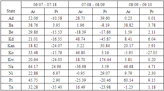
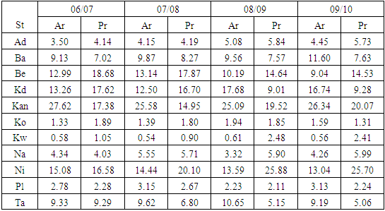
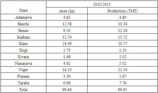
Given the extent of farming activities, the overall percentage of change in land cultivated with groundnut stood at 34.41% all through 2006 to 2008 at the regional level (Table 3). But among the individual states, a deep contrast emerges between the big state producers and those at the lower and medium tiers in production capacity and land cultivation. In that way, the states of Adamawa and Nassarawa boosted their fortunes in the sector by their respective gains of 52.06 to 64.17% as Plateau followed up with 45.75 increments in the proportion of groundnut land size. In a similar vein, the land base in both Kogi and Kwara however, plummeted by 33.48 to 20.64% as well. In the big area states where both Kaduna and Niger posted gains of over 20 percentage points, Kano state being the center of groundnut farming finished at only 18.82% during the same periods. In the mid-level states of the region, Bauchi and Taraba had increments of more than 30% as Benue’s proportion of variations in land planted with groundnut at 29.86% moved close to 30% with notable changes. On the changes in the volume of production, only 4 (Niger, Plateau and Bauchi, Nassarawa) out of 11 states made some gains whereas many of the states 7 in number recorded double digits declines across the board. In the breakdown of the losses, see that Kwara and Kano incurred the heaviest declines of 24% as Kaduna, Benue, Kogi and Adamawa’s levels of declines ranged from over 15-16% plus to -10.58%. The increases of 6.97, 2.9%, and 3.95 for Niger, Plateau and Bauchi in peanut production as significant as they were, stayed quite below Nassarawa’s level of gains of 24.96% from the fiscal years 2006 through 2008. Further along those lines, during 2007-2009 when 4 states (Adamawa, Kano, Kogi, Kwara) saw back-to-back growth in both production and cultivated area (Table 3). The two adjoining Middle Belt states of Benue and Plateau experienced outright declines of large double-digit proportions in both groundnut output and size of land area than the other states, while the levels for the others ended in an even split. In terms of the actual order of the back-to-back losses in both production and land areas, the deficits in Benue and Plateau stood at -18.39 to-17.86% and over 20% respectively between 2007-2009. Seeing that the states with complete gains includes Adamawa, Kano, Kogi and Kwara. The distribution of increments stood at 8.75-39.6% to 3.22-30.84% for the first two states and 46.8-3.16% to 18.7-174.44% for the other duo.The percentage of individual states from the regional total of peanuts planted areas and the production of the crop offers an interesting comparison among the top three; Kano, Kaduna and Niger representing the large producing states. With its place as the iconic home of groundnut pyramids in the 1950s and 1960s, Kano’s percentage proportions of 27.62 in peanuts land areas in 2006/2007 exceeded those of its immediate competitors. This includes states like Niger and Kaduna who held only15.08 -13.26% of the land base (Table 3.1). Even at that, the mid-level states of Bauchi and Benue stayed in the mix in terms of the percent coverage of the two key indicators with 9.13 -12.99%. In the production category, Benue’s strong jump from its mid-level status to top tier finisher with 18.68% ahead of big producing states of Kano, Kaduna and Niger at +17% -16 plus clearly affirms the level of output volatility inherent in the zone. This is in line with the efficiency of mid-level states like Bauchi where production proportions out of the regional total in 2006-2007 stood at 7.02%. Considering that the percentage rankings in 2007/2008 reflects the temporal patterns on the previous years with Kano and Niger ahead of others in the cultivated land areas coupled with another surge from Benue. Niger state’s percent share of production at 20.1% in 2007/2008 outpaced the rest of the states as Benue again emerged as the second-best finisher at 17.87% before Kaduna and Kano with output rates of 16.7-14.95%. By 2008/2009, Kano, Kaduna and Niger again held much of the land areas at 25.09, 17.68%-13.59 with planted fields for the other two states (Benue and Bauchi) representing only 9.56-10.19% of the regional total. The production levels at the same time, indicates Niger’s surge at 25.88% seemed closer to Kano and Benue at 19.52 to 14.64%, as the states of Kaduna and Bauchi maintained just single digit values of only 9.01-7.57%. In the remaining years, Kano still held the upper hands in terms of land areas and production at 26.34- 20.07% compared to Niger where the core peanut land use indictors were valued at 13.04-25.7% as Kaduna fell by 16.74 to 9.28%. The lower-level states of Benue and Bauchi on their part held firm in their respective rankings in the listing at 11.6-7.63% to 9.04-14.53% by 2009-2010. Again in 2010/2011, Kano and Niger states held on again to their dominant positions in the ranking order by 24.49-20.77% to 14.13-21.54% while Kaduna slid further to 12.74-11.72%. Towards the periods 2010/2011, both Benue and Bauchi waxed stronger from their percentage values of 12.58-10.34 to 9.5-12.18% (Table 3.1-3.1b).Table 3. Percentage of Change of Ground Nut Areas Planted in thousand Hectares and Production in TMT by State 2006- 2010
 |
| |
|
Table 3.1. Percentage of Individual State from Regional Total of Ground Nut Areas Planted in thousand Hectares and Production in TMT by State
 |
| |
|
Table 3.1b. Percentage of Individual State from Regional Total on Ground Nut Areas Planted in thousand Hectares and Production in TMT
 |
| |
|
3.2. Impact Assessment
From the pace of peanut production activities among the states in the study area. There exist widespread impacts of varying levels over the years in Northern Nigeria’s groundnut belt with ecological and socio-economic implications.
3.2.1. Ecological Risks from Surge in Fertilizer Use
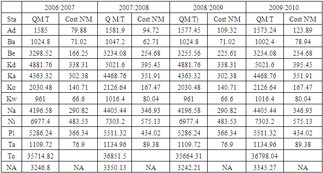
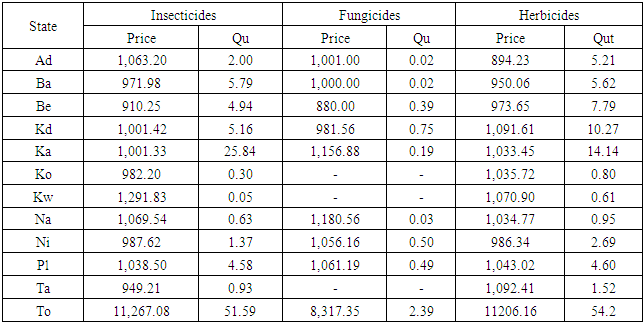
Considering the current spate of higher quality control measures upon which groundnut products from West Africa undergo rigorous safety scrutiny under the standards set by the European Union in the past decade. This level of heightened control continues to impose limiting effects on the export of West Africa’s peanut oil into the European markets as precautions against the influx of tainted products. Yet in the fiscal years 2006-2010, the quantity of fertilizers applied during farming seasons in peanut producing states in the study area reached record levels. This covers about 35714.82, 36851.5,35664.31-36798.04 metric tons (TMT) with serous ecological and human health implications between 2006 to 2010 (Table 4). Thus, based on the display, it remains obvious, that the spraying of fertilizers by peanut farms in the entire region appears to be on the rise in a way capable of threatening the adjoining lakes and rivers and the farm produce.Given that the same can be said of the actual pricing of fertilizers among the states, Niger, Plateau, Kano, and Kaduna states did spread more areas with fertilizers at higher levels of costs than their neighboring areas. However, Niger state’s elevated volumes of application and costs of nutrient procurements in its farm activities based on 6977.4 MT -N 483.53 to 7303.2 MT -N575.13 in used fertilizer and prices topped the rest of the states in the region all through 2006-2010. At the same time, both the fertilizer use(s) quantity and prices did rise remarkably in most of the states in the region as at 2006-2008 and 2008-2010 until the sudden declines in 2007-2009 in all most all of them (Table 4.1). Nevertheless, the producing states of peanuts in Nigeria’s Northern region remained actively involved in the use of agrochemicals of all types beginning with vast treatment of farm fields with fungicide, herbicides, and insecticides to ward off pests and insects threatening the storage and production of peanut crops in the zone (Table 4.1). The other far-reaching implications stems from the risks posed to quality of the peanuts in meeting stipulated health standards in the marketplace because of accumulated chemical residues on the products.Table 4. Quantity, Cost, Average Price of Fertilizer by State: 2006/07 - 2009/2010
 |
| |
|
Table 4.1. Distribution of Farm Agrichemicals (Quantity and Price)'000 metric tons price per kg (N) by State 2010
 |
| |
|
3.2.2. Changes in Land Areas and Production
The pace of emergent changes involved a mix of gains and declines with land areas surging much of the time amidst heavy losses in production levels in one fiscal year in Nigeria’s Northern region’ groundnut producing states. The robust gains in the size of cultivated areas during the periods 2006-2008 remained visible in the 11 states with extensions into 2007-2009 to 2009 and 2008-2010.These were the cases in the study area from Adamawa to Taraba which highlighted a promising sign for a rebounding sector out to regain the prominence of the 1950s to the 1960s. However, the drops in output by 2006-2008 in 7 of 11 states were large enough to slow down the sector given the shortfalls in domestic demand estimated at 300,000 to 400,000 metric tons. Nevertheless, the notable rebounds in 2007-2009 and 2008-2010 seemed sufficient in containing the losses through the spill overs from stable production that calmed the markets to some degree.
3.2.3. Mixed Economic and Environmental Effects
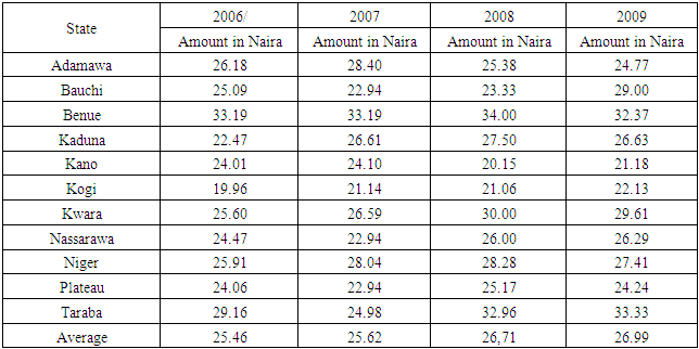
Considering that the average farm gate prices increased slightly throughout the years. With time, they seemed relatively stable over the years across the region at N25.46 – N25.62 during the periods 2006 and 2007. In the ensuing years it jumped from N26.71 to N26.99 naira at an average of N26.19. Of the states under analysis, the average farm gate price of N33.18, N30,1 to N27.4 for Benue, Taraba and Niger states exceeded the regional average of N26.19 (Table 5.1.) This raises concerns about the fate of small farm operators and their capacity to be competitive and viable amidst the operational advantages of bigger farms that are better equipped to absorb market shocks and fluctuations precipitated by pressures in policy and global marketplace and consumers, hence their role in the changes that occurred in the sector. At the same time, knowing that following the discovery of oil, Nigeria’s exports of shelled peanuts dropped from over ½ million MT in 1961 to over 200,000 MT in 1970 and to zero by 1980, environmental stressors like drought and aflatoxin contamination seemed related to the near collapse in export. Such a sudden drop-in export activities due to weak production activities and the declines in land areas provides opportunities to those solely interested in conversion of peanut farm spaces to competing land uses. This not only results in acute scarcity of poultry products due to the scarcity of groundnuts, but it does trigger increases in the prices of poultry food as well. Table 5. Farm Gate Price by Crop and State In Naira For Ground Nut by State 2006-2009
 |
| |
|
3.3. GIS Mapping and Spatial Analysis
The GIS analysis consists of the visual display of spatial patterns pinpointing production, land use and the costs of seedlings used. With that are the varying activities depicting applications of chemicals and the agro-ecosystem component of the zone crucial in peanut land use activities across the states over time. From the attributes of the indicators in space, the changes, together with the production volumes in Northern Nigeria’s groundnut Belt. The information conveyed through visual analytics under various scales and colors reflects evolving directions of the sector. The capability to visualize spatial-temporal evolution of production activities across the vast farm fields using GIS as investigative device, is vital in understanding the state of groundnut farmland use and the potentials in Northern Nigeria, now on the path towards revival. The GIS mappings of the trends shows gradual dispersal and expansion of groundnut producing areas into different portions of Northern Nigeria. With the pace of such dispersal in place along the Northern zone of the country. It is evidence that the harvesting of peanuts seemed confined predominantly to the middle belt portions of the map denoted in light yellow starting on the left side with Kwara, Niger, Kogi, Nassarawa, Plateau and Benue in the North Central and the Kano area in the upper north as well. With time in 2008-2012, came robust resurgence of the Middle Belt states (from Niger to Benue) in dark and light green colors with 9-14% values as active players in groundnut production (Figure 2). In other words, the map presents a spatial indicator in green and light colors highlighting the summation of percentage averages of peanut outputs from the fiscal years 2008-2018 in the study area. The averages of peanuts production in the thousands of tons reflects the place of Niger state as the leading state responsible for 14% of the output in 2008-2012 together with the trio of states (Kano, Kaduna and Bauchi) which accounted for 9% of peanuts. Aside from the trends for Nassarawa and Taraba at 5-6 percentage averages and Adamawa’s 3% average levels in peanut production during those periods, Kwara and Kogi in the Lower end of the Middle Belt, maintained just 2% below their other neighbors in the study area (Figure 2). That was further followed by a strong showing among the states of Niger, Kano, and Benue under varying scales in the percentage of individual state activities in regional production of groundnut during the years 2006-2007 and 2009-2010 in the lower, upper, and central sides of the map (Figure 3). 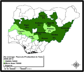 | Figure 2. Spatial Distribution of Groundnuts Output 2008-2012 |
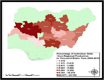 | Figure 3. The Individual State Output As Proportion of Regional Total 2009-2010 |
Added to the listing in 2006-2007 were bunch of other Middle Belt states made up of Taraba, Bauchi and Nassarawa, Adamawa and Plateau that remained actively involved in the mix in groundnut cultivation and production (Figure 3.1). In addition to that, under the percentage of change in groundnut production in 2006-2008, not only did Nassarawa state hold firm at higher scales that exceeded others at 6.971-24.960. Niger state followed up in that group of areas with 10.57-6.97 as the remaining states finished at high double-digit losses as well during the same period. In the fiscal year 2008-2010, emerged a strong concentration of areas with percentage gains in production dispersed across the up-state areas (Kano and Kaduna in purple or blue and along the lower states such as Niger and Benue in light green (Figure 4-4.1). The others include Nassarawa, Bauchi and Taraba amidst the visible presence of Plateau in the gain category. Aside from that, Kwara, Adamawa and Kogi in orange and beige saw the largest drops estimated in double digits (Fig 4.1). 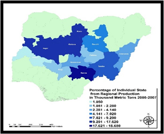 | Figure 3.1. Individual State Output As Proportion of Regional Total 2006-2007 |
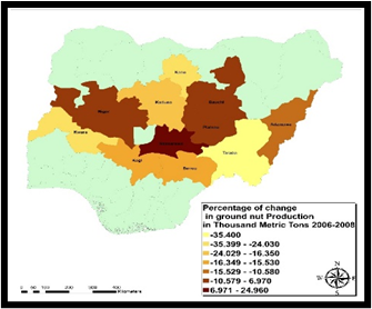 | Figure 4. Percentage of Change In Peanut Output, 2006-2008 |
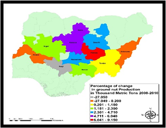 | Figure 4.1. Percentage of Change In Peanut Output, 2008-2010 |
Seeing the dependence of most producers on agrochemical usage in the treatment of groundnut farm fields with herbicides and fungicides. The percentage of total regional distribution among individual states as characterized by the geographic patterns in 2010, points to the dominance of Kano and Kaduna represented in dark red colors respectively on both maps (Figure 5-5.1). A further breakdown of the spatial diffusion of the rates of herbicides distribution in 2010 based on the info contained in the map legends among the next group of states (in orange and light orange) reveals a gradual spread from Bauchi state, Kaduna, Plateau to Benue as Adamawa, and quintet of other states like Niger, Taraba, Nasasrawa, Kwara and Kogi finished in the medium and lower end of the scale (Figure 5). When it comes to farm fungicides distribution, the trio of middle Belt states of Niger, Plateau and Benue held the medium spots in dark and light orange clustered in Central Nigeria’s axis followed by Bauchi, Adamawa and Nassarawa (Figure 5.1). 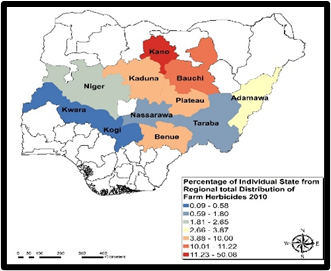 | Figure 5. The Regional Distribution of Farm Herbicides 2010 |
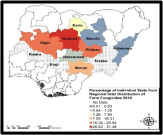 | Figure 5.1. The Regional Distribution of Farm Fungicides 2010 |
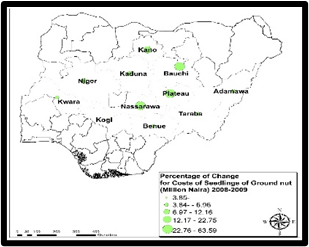
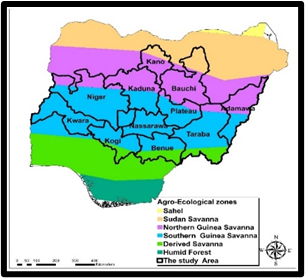
Regarding the costs of seedlings, even though Kaduna and Kogi held on the top spots in terms of gains in the percentage of changes in 2007-2008 compared to the other states during 2007-2008, within the same periods, the map showed clusters of areas represented in purple colors in space from Kano to Kwara, Adamawa and Taraba where the costs of peanuts seeds faded (Figure 6). By 2008-2009, a different spatial pattern in oval green objects emerges in which Bauchi, Plateau, and Nassarrawa states overtook the rest of the states who dropped further below in the percentage values (Figure 6.1). The scope of changes in the state of peanut production and land use activities were made possible by the physical attributes of the agro-ecological zones and the landscape parameters (Figures 7-7.2). Therefore, assessing the geographic scope of peanut farming in the study area would be incomplete without a profile of the physical conditions in the ecological zones where planting activities thrive. With the diverse zones (Northern and Southern Guinea Savannah and the Sudan Savannah distinguished under different colors of purple and light blue and Orange. Both the Northern Guinea Savanah and Sudan Savanah agricultural ecozones representing the Northmost parts of study area starts within the vicinity of upper portions of Kano and Bauchi axis alongside Kaduna and Adamawa. Down in the Middle are many other states along the Southern Guinea Savannah from Niger, Kwara, Nassarawa, Plateau, Taraba, Benue and Kogi with extension onto the Derived Savannah zone in light green (Figure 9). Of great importance in the fiscal year 2000, are the spatial dispersion of pasture and cropland spread across some of the states, but with Niger and Plateau showing more concentration of pastures. Elsewhere, Kogi in the lower area, together with parts of Kano and Plateau contained notable cropland presence during the same period (Figure 9.2-9.3).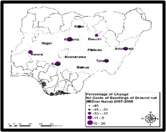 | Figure 6. The Percentage of Change In Costs of Ground Seedlings 2007-2008 |
 | Figure 6.1. The Percentage of Change In Costs of Ground Seedlings 2008-2009 |
 | Figure 7. The Spatial Locations of The Agricultural Ecozones |
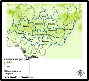 | Figure 7.1. The Distribution of Pasture Land In 2000 |
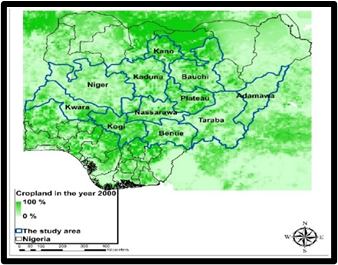 | Figure 7.2. The Geographic Distribution of Cropland, In 2000 |
3.4. Factors Driving Changing Groundnut Land Use
The underlying elements driving the activities responsible for the changing groundnut landuse in Northern Nigeria do not occur in isolation. They are associated with various policy, socio-economic, and physical-environmental factors. These elements are explored fully in the following paragraphs.
3.4.1. Policy Elements
Nigerian groundnut farmers like others, saw the nation’s central government role as major actor in the implementation of farm policy instruments of subsidized production system ended in the mid-1980s. Prior to that material time, Federal authorities often pushed the agenda through the setting of prices, together with purchases and export promotion through various farm commodity marketing boards. Even though all these programs were sustained also by the concerted efforts and support of the major agricultural research and extension services to the benefit of framers. The myopic acceptance of the International Monetary Funds’ structural Adjustment Programme (SAP) as a remedy towards the economic revival of many Third world debtor nations in the mid-1980s generated a sudden exposure for the nation’s peanut sector to unwanted liabilities given the volatility of the fiscal spill over to the market. In that way, the adoption of new reforms ended government direct participation in agricultural markets, production, and farm extension services. As a result, the government’s role was limited to regulation and policy, while demand and supply laws controlled the operation of markets. Because of that, the groundnut marketing boards were disbanded in 1986 and the private sector took over the functions of the boards. The other major policy failure tagged currency devaluation that impeded the sector, under the SAP, led to reduced funding for public research and extension services. Such IMF conditionality caught local farmers unready, amidst lower returns from investments and competition. This is different from the strong safety net enjoyed by foreign competitors and farmers from other nations where entrenched systems of sophisticated policy infrastructure and stronger institutions at the disposal of peanut growers run far deeper than in Nigeria.
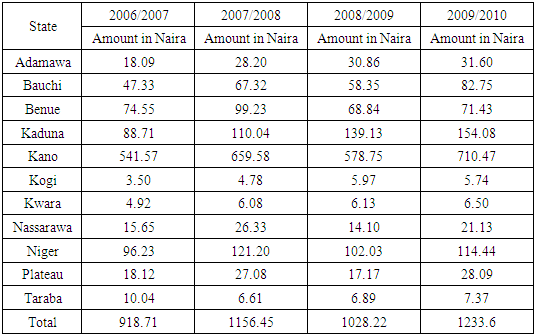
3.4.2. Socio-Economic Forces and Demography
The essence of peanut oil to people involves the use in dish cooking with health benefits and as vital part of a balanced diet. Nationwide peanut oil use is highly influenced by the growing population, rise in fast food joints and export revenues. This is relevant in the study area’s population figures where regional average changes between 1991 through 2016 reached over 114% in gains among the 11 states with implications on land use. With over 10 peanut oil producing firms nationwide using quality extraction machines to meet consumer needs in the face of changing population. The extraction of oil from peanut in such settings constitutes vital farm processing activity for women in Nigeria’s Northern states. Accordingly, the ban on the import of other edible oils in Nigeria sparked local production of peanuts, buoyed by a surge in demand with likely influence on landuse. Even though the surge in peanut output nationwide is indicative of the viability of bumper harvests among Northern farmers. One should not forget that these farmers still face huge farm gate and transportation costs in the face of poor road access and amenities (Table 5-5.1). This happened as the costs of seeds rose drastically in the entire region from N918.71-N 1156.45 to N1028.22 to N1233.6 (Table 6) to the detriment of those farmers left to bear the brunt of market uncertainties. Such changes were likely to force the loss of peanut landscape to incompatible land uses considering the growth in teeming populations in the zone. Serving the needs of such a teeming populace and those beyond the region and other parts of Nigeria and the pressures unleashed from urbanization into the farming spaces, did leave major negative footprint on the agricultural ecosystem. Table 6. Costs of Seed/Seedlings of Groundnut (Million Naira) by State 2006-2010
 |
| |
|
3.4.3. Physical Environment and Technology
The cultivation of peanut crop thrives in rainy conditions in semi-arid areas at ideal soil temp of 300°C with better drainage and high fertility. In that case, the scope of groundnut farming activities over the years as fully manifested in the 11 states in the areas seems better suited to the production of the crop in the nation’s savannah agroecological zones. Being a region that stretches through a diverse ecozone, where production activities flourished under the prevailing physical conditions peculiar to the derived savannah states of Benue to Niger and Adamawa state in the South Guinea savannah area. Among the others, Kano’s peanut fields operate in areas known for a mix of Sudan Savanah and Northern Guinea. Under those environments, the peanut farming activities in the region is no stranger to the risks from changing climatic parameters like limited farm output prompted by the outbreak of deadly droughts in the 1980s, and the exposure of peanuts to the spread of plant diseases. While the outbreak of aflatoxin disease limited the level of groundnut farm productivity in the zone with implications on land retention and losses. Innovative extraction activities using groundnut oil machine and its enhancement of entire production process with delivery of quality goods to consumers, may have played a role in the use of land as well in the region.
3.5. Efforts and Initiatives
Seeing the enviable history of groundnut production in the Northern region between the golden era of the 1950s-1960s to the downturn in 1980s and the current moves towards a resurgence. Various actions are being put into place collaboratively by state agencies and other stakeholders to regain the magic touch of the past and improve the fortunes of peanut industry in Nigeria’s Northern region.
3.5.1. The Moves Towards Sectorial Revival
In a bid to revive the peanut sector, the Central Bank of Nigeria has initiated an ambitious scheme with large sums of financial capital earmarked to accelerate cultivation of the produce. Further, the relocation of the African Groundnut Council to Kano and the later improvement of research and output of the crop state-wide injected the much-needed spark, signalling interest to the return of famous groundnut pyramids of Kano, associated with renowned eras of the 1950s-1960s. Under the Agricultural Transformation Agenda (ATA) to grow the economy and improve the welfare of the citizenry, the Federal Ministry of Agriculture launched the Groundnut Value Chain as part of the crop-based programs of the ATA. In line with the broad focus, the sector and the Ministry would be working with the International Crops Research Institute for the Semi-Arid Tropics (ICRISAT)s, the globe leading Center for research in groundnuts and sorghum. For the ministry, the venture stands as a milestone in the government’s plan to transform the agricultural sector of Nigeria in a bid to enhance peanut output, processing, and value added for local and export markets nationwide. In accordance with the glory days of the groundnut pyramid, when Nigeria controlled 40% of the world market, current efforts are aimed at lifting the sector back into prominence. Elsewhere, the state director of ATA, opined also that the Federal government and Kaduna state were exploring the viability of dry season groundnut farming to achieve better production. Since part of the major challenge stems from limited access and inadequate seeds to meet the demands of farmers. Under the joint venture, the Federal government has shown commitment towards the provision and access to improved variety of seeds in the state. In the process, many farmers who showed interests in the new variety of seeds and different kinds of groundnut received the distributed portions of seedlings for trial on their farms in July 2014. As part of a follow up around farms, it was discovered that the initial cultivation trials were so successful that after two months of trials, the farmers began ordering it for the seedlings. This coincides also with the focus on involvement and collaboration with others in conjunction with stakeholders along the value chain side to improve the production, processing, marketing, and export of the produce. Part of the proposed revitalization scheme based on the efforts, can be achieved by improving the profitability of peanut output through the genetic base increments, improved cultivars, and agronomic practices suitable to farmers and the market requirements. The other aspects of the efforts coincide with ICRISAT’s role in researching the risks posed by aflatoxin to peanut farming. This not only resulted in the design of ‘Aflatoxin kit’ elsewhere in Malawi, but it stands as a plus for farmers in Northern Nigeria who saw the threats posed by the toxin to peanut crops before.
4. Discussion
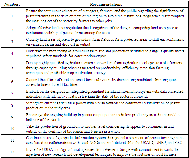
The research emphasized the extent and form of groundnut farmland use by assessing the trends, pertaining to composition and availability under varying indicators in the form of groundnut areas planted and production volumes across the region and the states. While vital aspects in the enquiry cover the proportion of changes based on gains and declines in land resource assets and the attendant challenges. The other essential components of the assessments entail the delineation of current linkages between peanut land use, production activities, food security and the host of policy, socio-economic, ecological, and physical factors. This comprises of population surge, fluctuating prices in farm products, widespread applications of fertilizers and agricultural-chemicals and pollution threats. Based on the findings, the state of peanut land use in Nigeria’s Northern zone seems promising and intact considering the versatility of options in terms of the potentials in place with much abundance aside from the periodic dangers posed by crop disease outbreaks. Of great interest is the concentration of output and cultivated land areas in a trio of states (Kano. Niger and Kaduna) with first tier classifications and the others listed in the second and third category based on their respective activities over the years. With both the leading states above their neighbours, the lower tier states in output and land size in the Middle Belt remained quite impressive as well. Being in an arid and semi region of Nigeria where groundnut is chiefly planted and situated, in the largely Middle Belt zone along Central Nigeria, under the savannah ecozone adjacent to the two major rivers with large swaths of land base. In the nation’s economic history, peanut farming enjoys a special status at the height of its eminence during the pre-and post-colonial periods. The crop was not only critical in revenue generation for the nation and the Northern region. But it bolstered the development aspirations in various ways until a gradual decline in exports by over half a million to over 200,000 MT from 1961-1970 with the discovery of oil. Realizing the potentials of groundnut, the Federal government of Nigeria waisted not time in laying out the path towards resurgence through series of policy measures to boost output in the foreseeable future within the North. The anticipated turnaround seems to be driving the current surge in production and land base activities in the producing states in the study area. This coincides with current efforts among various agencies in research and development and the revitalization of the sector to increase peanut output. The moves involve the proindustry visions of the Central Bank, relocation of the African Groundnut Council to Kano, and the collaborative actions of the Federal Ministry of Agriculture to enhance research in peanut with other agencies. Part of the emphasis among agencies like ICRISAT involved studies into aflatoxin problem in peanut which resulted in the design of aflatoxin kit’ essential to farmers in the Northern region.To track the extent of groundnut land use trends, production activities, changes in the core indicators and declines in peanut as a major export crop, the threats of ecological degradation, and host of factors, alongside past and present worries. The paper adopted mixscale model of descriptive statistics and GIS with information covering array of socio-economic, physical, ecological, and agro-chemical indicators like percentage of change in peanut output, farm agrochemicals, pastureland, farm gate price, costs and percentage of groundnut seeds and cropland. Of immense significance in the analysis is that despite the strong performance by the big three states (Kano, Niger, and Kaduna), the second tier of states of Benue, Bauchi and Taraba did show their capacity. All in all, the zone as the key frontier still has vast potentials in groundnut farming even though it is somewhat different from the scale of activities in the 1950s and 1960s. Accordingly, the increases at the regional level stems from large volume of activities involving 1494.03 ha to 1974.8 TMT and about 1572.33 ha-1979.79 between 2007 through 2010, respectively. Just as the geospatial analysis of the trends using GIS all through FY 2000 to 2012 highlighted the concentration and dispersal of groundnut farm indicators onto various producing areas in the Northern region. The proliferation of agrochemicals involving pesticides, fungicides and farm nutrients magnified the risks on the surrounding ecosystems in the zone. Added to that, the changes in groundnut farmland use which did not occur in a vacuum stem from policy, socio-economic, demographic, physical, environmental and tech elements. Notwithstanding the ample benefits demonstrated herein for planners in evaluating the problems and challenges faced by groundnut farming in multi-state settings in a region and country. To mitigate the issues arising, the paper proffered solutions ranging from the need for the education of managers and farmers to the design of an integrated groundnut farmland information system with data on related indicators under interactive features tracking the state of the sector regionwide. For more details on the recommendations, see Table 7 in Appendix A.
5. Conclusions
This study focused on an assessment of groundnut farmland use based on production, size, and the effects on some selected states in Nigeria’s Northern region with important results listed under the following headings: a) The Northern region has great potentials; b) peanut in abundance; c) changes evident in land use indicators; d) mix scale methods effective; e) changes prompted by various factors; f) environmental impacts evident. The integral portion of this research outcome recognizes the abundance of peanut in Nigeria’s Northern region. In a nation where groundnut is planted mainly in the Northern zone’s arid ecozone particularly Kano and central Nigeria, there appears to be large presence of the crop therein. Being the hub with ample potentials, the Northern region has always been the major frontier in groundnut farmland use in Nigeria. With those prospects evident amidst various efforts to revive the sector by the Federal government. In the early days of Nigeria’s development, when groundnut farming stood out as engine of the economy, the crop mainly from the North not only fuelled development aspirations at the regional and Federal levels through the generation of enough returns. The presence was so visibly felt and manifested in various forms not imagined for any product before, that it captured the nation’s popular imagination beginning with “groundnut pyramids” underscoring productivity, abundance, and export of the crop in both local and foreign marketplaces. Between 1956 and 1967, groundnuts generated vast proportions of the nation’s overall export revenues with the Northern zone the major source. This coincides with a time the nation dominated globally as leading producer in the 1960s and early 1970s at production capacity which went from 500,000 MT-1.6 MT. Even now, it still accounts for 25% of global exports. With Nigeria ranked third highest producer of groundnut in the world behind China and India in 2011, again there is no way to be in that category under current challenges and neglect without the Northern region in the mix. Other instances of abundance and potentials in the context of groundnut farming activities in Northern states involves variations in output and the land areas planted all through 2006 to 2012. Seeing that the zone’s 1164.19 hectares to 2237.6 thousand metric tons in the size of cultivated fields and volume of output stood at relative averages of 105.83 ha to 203.41TMT. The scope of those activities as indicative of the intense level of operations during 2006/2007 and beyond in the zone far exceeds other regions in the country. In stressing these potentials, this enquiry presented new ways that are essential for resurgence and better outlook of the sector and region.Another inference that can be drawn through the results comes from the level of changes in peanut land use all through 2006 to 2012 in Northern Nigeria. From what really occurred in farm activities pertaining to the core land use indicators of cultivated areas and the quantity of peanuts produced in the years under analysis. The scale of change as demonstrated in the temporal profile, reflects dynamic snapshots of a mix of gains and declines. Under that scenario, the size of land areas surged much of time amidst heavy losses in production levels particularly in one fiscal year among Northern region’s groundnut producing states. The scope of gains in the size of cultivated areas during the periods 2006-2008 was so robust that it showed ample visibility in the 11 states with extensions deep into 2007-2009 to 2009 and 2008-2010. While these were the case in the study area from Adamawa to Taraba which showed flashes of promise for a sector destined to recapture its past prominence in the globe. Given the scale of farming activities, the overall rate of change in cultivated area stood at 34.41% by 2006 to 2008 at the regional level as Adamawa and Nassarawa saw gains of over 50-60% by 2008-2010. In that way, the groundnut producing states not only served notice, but they remained on target to match the levels of the 1950s to the 1960s and the late 20th century. However, visible drops in production during 2006-2008 in 7 of 11 states or 63.63% of the peanut producing areas are concerns enough to slow down output given the drops in domestic demand at 300,000 to 400,000 MT. Nevertheless, the rebounds during the periods 2007-2010 did offset such losses. Identifying those changes and the synopsis of the trends as an upside in land use informatics ushered in the contours necessary in the design of a groundnut land index and information system for the region.Applying descriptive statistics and GIS tools of the mixscale model as working devices injected further insights to the assessment of groundnut farming activities. The model was quite efficient in detecting the trends, factors, efforts, and ecosystem impacts and change. Consequently, the use of descriptive statistics in that fashion highlighted the capability of the techniques in categorising peanut production activities, and cultivated areas among the states based on consumption, farm gate prices and other indicators under varying scales. From the degree to which GIS mappings revealed the geographic patterns of groundnut production and the individual state output on various farms. The model injected a valued flair in visualizing the spatial concentration in the percentage of change in peanut output, and points in space where the percentage of change in costs of groundnut seedlings and spatial locations of the agricultural ecozones, and geographic distribution of cropland remained intact. Other visual coverages also pinpointed the regional distribution patterns of ecological risk indicators in the form of farm fungicides and herbicides in Nigeria’s Northern region. With the uses in mapping analytics and impact assessment of peanut land use in Nigeria’s Northern zone, GIS exhibited full promise in presenting the location and scope of potential ecological risks and the extent of their diffusion. Highlighting these issues, helps shift the emphasis in future planning into places where probable exposures to degradation given the rising procurement in farm chemicals in the zone and threats to surrounding ecosystem could be imminent. For that, the study included an ecosystem safeguard component. Getting groundnut producing areas aware of these eventualities as demonstrated in the study, minimizes their exposures.Realizing that changes in groundnut farming reflect host of factors made up of policy, socio-economic elements, demography, physical environment, and advances in technology. The abysmal policies in the 1970s and 1980s held back the sector such that it fell below its levels in the 1950s and 1960s due to the elements located within the larger farm structure. As a result, the obsession with oil boom and the elimination of subsidy in the mid-1980s under SAP conditionality as a policy, stripped groundnut farming the required safety nets and relevance amidst lower output. Regardless of those drawbacks, socio-economic and demographic forces still ensured widespread usage of the produce through a growing appeal among consumers with increases in food joints attributed to regional average changes in population estimated at more than 114% from 1991 to 2016. Considering the characteristics of these indicators over time. In Essence, the dynamic forces driving global market needs to some extent, spurred the demands for the crop and related products. Thus, the rise in the production of peanut and cultivated land areas over time, in a way shaped the activities in the sector amidst change. Furthermore, the agricultural ecology in semi-arid zones of the North characterized by indicators like temperature, rain fall and fertile land area favorable for the cultivation of groundnut crop were vital in the increased output as manifested in the zone during the past years. As the most semi-arid zone in the nation, the spectre of rain and high temp of 300 degrees common in the area between 2006-2012 remained consistent in the respective states in the North, that they optimized peanut output and cultivation. Also, the processing activities reliant on peanut oil machineries not only quickened production process through prompt distribution to users, but it was quite essential in land use retention in the zone. Drawing on the overlaps with the current enabling environment created by the Federal Government of Nigeria through the Ministry of Agriculture, the Central Bank and other institutions aimed at reviving the sector. The study in re-echoing the value of these elements in the region’s peanut farm activities affirmed their influence in the sector in way that can shape ongoing debates. Essentially, the impacts of groundnut land use on Northern Nigeria’s ecosystem are evident from the array of activities that transpired therein. Since groundnut operations and the core indicators germane to production consistent with other forms of farming trigger notable impacts on the arid Northern agricultural ecosystem. The emergent negative footprints as common trends in land use interactions among various parameters poses enormous risks to the region’s environment. While the high level of quality control restrictions already imposed on groundnut products from West Africa attests to concerns over the risks from fertilizer use, the applications of agro-chemicals and exposures to environmental stressors during the production process. In the fiscal years 2006-2010, the volume of fertilizer applications in the peanut producing states in the study area rose significantly together with the high costs of nutrient procurements in a handful of Northern states with risks to the adjoining lakes and rivers and the farm produces as well. Aside from the way the Sahel drought events in the mid-1970s unleashed aphid diseases that damaged vast areas of peanut landscape in the region, aflatoxin contamination delivered similar mayhem in the zone with the sudden fall in exports. This coincided with the conversion of arable groundnut fields in some areas in the North to competing land uses. Considering the present concerns over ecological footprints of peanut production in the policy domain and heightened interest to revive the sector. The belief is that key actors will seek insights from this study at a time many are longing for new directions mindful of the essence of environment-economy interface in the sector. As a result, policy makers and researchers will demand quick answers to vital questions emanating herein. The questions are: what shape will peanut land use and production take in future? How will the region track the scale of farm nutrient flow into the ecosystem? How will the anticipated revival of the sector influence land use and production in the zone? How will the zone benefit from the design of an integrated digital regional land use index? Which critical indices will be embedded in a land use information system? How prepared is the region in absorbing fiscal shocks from global market volatility? How can we evaluate current moves to increase future output and what are the probable environmental implications? From these questions, ample opportunity exists to get the sector on track again to eminence and redirect groundnut land use and production methods into ways deeply entrenched in sustainability and environmental protection.
Appendix A
4.1. RecommendationsTable 7. Brief Remedies
 |
| |
|
Appendix B
Acronym
 |
| |
|
References
| [1] | Adebayo, Ismail. “60 Years After, Kano Groundnut Pyramids Site Turns to Football Field”. Daily Trust. Retrieved 17, April 2017. |
| [2] | Baraka, Bashir. “Groundnut Pyramids: Lost pride of the North”. Freedom Radio. Retrieved May 19, 2014. |
| [3] | Salu, Jide. “Nigeria's Groundnut Pyramids Soon To Resurface Akimwumi Adesina, Nigerian Minister of Agriculture spearheads revival”. Retrieved May 19, 2014. |
| [4] | Abubakar, Mohammed. “Jonathan In Kano, Promises Return Of Groundnut Pyramids”. The Guardian. Retrieved 9 June 2015. |
| [5] | Wikipedia. (2020). Online Available: https://en.wikipedia.org/wiki/Groundnut_pyramidsGroundnut pyramids Wikipedia, the free encyclopedia. |
| [6] | Agro Nigeria. (February 2014). Groundnut Production: Nigeria Set to Return to Dominance. |
| [7] | Foraminifera Market Research Limited. (2016) Groundnut Peanut Export In Nigeria; Non-Oil Export Opportunity In Nigeria. Ejigbo, Lagos. Available: https://foramfera.com/2016/03/04/groundnut-peanut-export-in-nigeria-non-oil-export-opportunity-in-nigeria. |
| [8] | Ani, Patience. (2013 September). Profitability and Economic Efficiency of Groundnut Production in Benue State, Nigeria. African Journal of Food, Agriculture, Nutrition and Development. |
| [9] | Usman, Ibrahim. (2013). Socio-economic Factors Affecting Groundnut Production In Sabongari Local Government of Kaduna State, Nigerian International Journal of Food and Agricultural Economics. 1:1: 41-48. |
| [10] | Ajeigbe, HA. (2015 April). Guide_to_Groundnut_Production_In_Nigeria. International Crops Research Institute For the Semi-Arid Tropics (ICRISAT). Kano: Nigeria 1-28. |
| [11] | Falae, Vivian. (2018). Factors Affecting Groundnut Production In Nigeria. Legit. Online Available: https://www.legit.ng/1136350-factors-affecting-groundnut-production-nigeria.html. |
| [12] | FAO. (2020). Nigeria At a Glance: FAO in Nigeria. FAO Rome: Italy. |
| [13] | ICRISAT International Crop Research Institute For Semi Arid. (2016 June). Agriculture. Nigerian Farmers Beat High Temperatures With Dry-Season Groundnut Varieties. ICRISAT. |
| [14] | Finilib. (2016). Groundnut Producing States In Nigeria And Its Commercial Uses. Finelib, Online Available: https://www.finelib.com/about/nigeria-cash-crops/groundnut-producing-states-in-nigeria-and-its-commerical-uses/. |
| [15] | Samuel, Patience. (2017 December). Analysis of Costs and Returns of Groundnut Processing in Taraba State, Nigeria. Journal of Research in Business and Management. 5: 6: 19-26. |
| [16] | Audu, S. I. (2017 Productivity and Profitability of Groundnut Production (Arachis hypogea L.) in Lafia Local Government Area, Nasarawa State, Nigeria. Asian Research Journal of Agriculture: 4:3:1-11. |
| [17] | Usman, M.A. (2016) Effect of Groundnut Shell Powder on the Mechanical Properties of Recycled Polyethylene and Its Biodegradability. Journal of Minerals and Materials Characterization and Engineering. 4: 228-240. |
| [18] | Kyauta, E.E. Availability Assessment of Groundnut and Beans Residue Using Remote Sensing and GIS-A Case Study of Bogoro Local Government Area, Bauchi State, Nigeria Journal of Remote Sensing & GIS. 7:3:1-5. |
| [19] | Pazderka, Catherine. (2010. June 17). Twin Case Study Chatham House Procurement for Development Forum: Groundnuts Case Study. Royal Institute For International Affairs, Chatham House. London: UK. |
| [20] | Girei1, A. A. (2013 December). An Economic Analysis of Groundnut (Arachis hypogea) Production In Hong Local Government Area of Adamawa State, Nigeria. Journal of Agricultural and Crop Research. 1:6: 84-89. |
| [21] | Taphe, B. G. (2015). Resource Productivity and Technical Efficiency of Small-Scale Groundnut Farmers in Taraba State, Nigeria. Journal of Biology, Agriculture and Healthcare, 5(17): 25-36. |
| [22] | Ani, D.P. (2013 September) Profitability and Economic Efficiency of Groundnut Production in Benue State. African Journal of Food, Agriculture, Nutrition, and Development. 13: 4. |
| [23] | Yusif, M. M. (2009). A New Politics of Agriculture in Kano-Nigeria: Groundnut for Chickens or Humans? WTO Mock Summit Paper .WTO Mock Summit Group in Bayero University, Kano. |
| [24] | Nwachukwu, Ikenna (July 2018). Do You Know Nigeria’s Groundnut Pyramids? What Happened to The Pyramids? Connect Nigeria. ConnectNigeria.com. Dolphin Estate Ikoyi. Lagos: Nigeria. |
| [25] | Taru, V. B. (2010). Profitability of Groundnut Production In Michika Local Government Area of Adamawa State. Nigerian Journal of Agricultural Science, 1:25-29. |
| [26] | Project/Naerls Zaria. Kaduna state Background and Issues 2.1 General Overview. Online Available: http://hubrural.org/IMG/pdf/nigeria_groundnut_report.pdf. |
| [27] | Hassan, Karofi. (2009 March) Nigeria: Why Groundnut Pyramids May Not Resurface Soon Daily. All Africa Online Available: https://allafrica.com/stories/200903091135.html. |
| [28] | ICRISAT (2018 October). Two to Tango: How Groundnut Production In Nigeria is Thriving On Synergy. Online Available: https://www.icrisat.org/two-to-tango-how-groundnut-production-in-nigeria-is-thriving-on-synergy. |
| [29] | African Framing Net 30. (2014 October). Nigerian government to revive groundnut farming in Kaduna. Online Available: https://www.africanfarming.net/crops/agriculture/nigerian-. |
| [30] | Merem, E. C. (2020). Appraising the Changing Trends In Oil Palm Farming in Nigeria’s Lower South Region. International Journal of Ecosystem. 10(1): 1-22. |
| [31] | Merem, E. C. (2020). Exploring Cocoa Farm Landuse Trends in The West African Region. International Journal of Agriculture and Forestry. 10:1: 19-39. |
| [32] | Merem, E. C. (2019). Analyzing the Tragedy of Illegal Fishing on the West African Coastal Region. International Journal of Food Science and Nutrition Engineering, 9:1: 1-15. |
| [33] | Merem, E. C. and Twumasi, Y. A. (2020, February). The Regional Analysis of Groundnut Farmland Use in Northern Nigeria. 87th Annual Conference of Association of Social and Behavioral Scientists, Inc (ASBS), Atlanta, 2020, March 4-. |
| [34] | Taru, V.B. (2008). Economic Efficiency of Resource Use in Groundnut Production in Adamawa State of Nigeria World Journal of Agricultural Sciences. 4: 896-900. |
| [35] | Nwanosike, M. R. O. (2011). Economic Analysis of Groundnut Enterprise in Rafi Local Government Area of Niger State, Nigeria. International Research Journal of Applied and Basic Sciences, 2(4): 155-162. |
| [36] | World Atlas. Where Are Peanuts Grown. Online Available: https://www.worldatlas.com/articles/top-peanut-groundnut-producing-countries.html. |
| [37] | J.A.C. Ezihe. (2017 November). Effect of climatic change and variability on groundnut (Arachis hypogea, L.) production in Nigeria. Bulgarian Journal of Agricultural Science 23: 6) 906-914. |
| [38] | Ojo, C. O., (2013). Gender Resource Accessibility and Profitability Among Groundnut Producers in Hong Local Government Area of Adamawa State, Nigeria. Department of Agricultural Economics, Faculty of Agriculture University of Maiduguri, Borno State, Nigeria. |
| [39] | Lawal, Haruna. (2018 March). Economics of Groundnut Production among Smallholder Farmers in Michika Local Government Area of Adamawa State, Nigeria. International Journal of Environment Agriculture and Biotechnology 3: 2: 373-379. |
| [40] | Federal Ministry of Agriculture of Nigeria (2010). Northern Nigerians Groundnut Data. National Bureau of Statistics. Abuja FCT: Nigeria. |
| [41] | National Bureau of Statistics/ Federal Ministry of Agriculture and Rural Development. (2011) Collaborative Survey on National Agriculture Sample Survey (nass), 2010/2011. |

 Abstract
 Reference
 Full-Text PDF
 Full-text HTML