-
Paper Information
- Previous Paper
- Paper Submission
-
Journal Information
- About This Journal
- Editorial Board
- Current Issue
- Archive
- Author Guidelines
- Contact Us
Energy and Power
p-ISSN: 2163-159X e-ISSN: 2163-1603
2013; 3(4): 44-50
doi:10.5923/j.ep.20130304.02
Yearly Average Maps of Solar Radiation in Azerbaijan
Fuad Mammadov
Azerbaijan State Oil Academy, D. Aliyeva 227,Baku, AZ1010, phone-fax (+99412) 4931764, Azerbaijan
Correspondence to: Fuad Mammadov, Azerbaijan State Oil Academy, D. Aliyeva 227,Baku, AZ1010, phone-fax (+99412) 4931764, Azerbaijan.
| Email: |  |
Copyright © 2012 Scientific & Academic Publishing. All Rights Reserved.
Due to his geographical location, climate condition and economical infrastructure peculiarities Azerbaijan is the most perspective region for renewable and alternative energy sources’ application. Today exhaust fossil fuels exhaust stock equal to ~2 billion tone crude oil and 2,2 billion m3 gas that concedes to Middle East on the quantity. On the other hand the predictions show that till 2030-2050 years crude oil consumption in Azerbaijan will consist of 50-55% and gas demand will be 20-25% which can lead appreciable depletion of hydrocarbon stock subject to their export. In this aspect it is necessary to notice that in majority of the regions of Azerbaijan solar energy potentials consist of averagely 1600-2000 kW-hour/m2 (including some cases till 2200 kW-hour/m2 in Nakhchivan Autonomous Republic). For application of solar energy objective evidence on solar energy potential is important. To solve practical tasks dealing with solar energy and to include its potential in Azerbaijan energy balance long term measurements should be carried out. Development of solar cadastre of Azerbaijan permits to estimate technically and economically beneficial variants of solar energy potentials during solar energy plants building in different regions of the Republic. By this purpose in Azerbaijan solar energy potential map was firstly established. Therefore during 6 years measurements at weather stations located in the several zones of the Republic have been carried out. Here average annual amount of sunshine hours, direct, diffuse and albedo solar radiations were determined. On the base of the obtained results solar energy potential maps were prepared. I should notice that maps of Azerbaijan solar energy potentials are to be published in this paper in first time.
Keywords: Solar Radiation, Sunshine Hours, Direct Radiation, Diffuse Radiation, Albedo Radiation
Cite this paper: Fuad Mammadov, Yearly Average Maps of Solar Radiation in Azerbaijan, Energy and Power, Vol. 3 No. 4, 2013, pp. 44-50. doi: 10.5923/j.ep.20130304.02.
Article Outline
1. Introduction
- Mainly energy sector causes environmental pollution and formation of hazardous gases leading green house effect in Azerbaijan. Gas emission per a person in Azerbaijan consists of 6-7 ton. According to the predictions this showing for 2020-2030 will be 9-10 ton. Such temperature increasing happens majorly because of oil (40-50%) and gas (35-45%) exploitation. Prevention of further ecological problems and energy crisis can be realized only at the expense of alternative and renewable energy sources. Thus replacement of the current fuel-energy sector into renewable energy sources will cause healthy life, natural safety, protection of flora and fauna. If we take into consideration that population Azerbaijan live in Absheron and the surrounding regions and already near 200 years oil and gas have been extracted here, in this case ecology clean energy application has great importance. For the solution of the practical questions put forward in this field of information on solar energy of the region is very necessary. Development of the information may induce new energy balance generation of Azerbaijan. Up today the well-known researchers E.M.Shikhlinski, A.A.Madatzadeh, V.M.Madatzadeh, Ch.A.Shver,A.D.Eyyubov, Sh.Y. Goychayli and other developed and established climate (temperature of soil and air, precipitation, radiation and heat balance, cloudiness, snow cover, relative humidity and so on) of Azerbaijan[1,2,3,4,5]. Though the deeds mentioned above, potential of renewable energy sources in none of the zones in the Republic have been determined. So in the communal buildings, houses, industry enterprises, in oil and power-engineering sector, there is a great deal of energy consuming processes. That’s why the average annual or average seasonal renewable energy potentials of the Republic should be known. Solar energy for the demanded power generation in industry sectors is to be certainly determined.Only in the case of determining sunshine, direct, diffuse and albedo solar radiations’ average annual marks in those places solar themal and power stations can be built. Though Azerbaijan has rich solar resources and in this field State Program was signed in 2004 in the Republic, none of database on solar energy potential for the country has been estblished. The neighboring countries, Turkey, Russia, Iran[6,7,8] have already processed their own solar energy potential maps. The first database on Azerbaijan solar energy potential was shown in the resaerches carried out by Dr, associate professor F.F.Mammadov[9].At the result of the measurements realized bt the existing metereological stations in the Republic till 1990 years and on the base of measurements done in the latest 6 years by us on the Republic average annual marksof direct, diffuse and albedo solar radiations have been determined. Due to the obtained conclusions solar energy potential maps covering entirely the Republic territory were established.
2. Analysis of Solar Radiation Measurements
- During the measurements beside data of 8 (eight) main meteorological stations information’s obtained from the mobile meteorological stations have been analysed. So the geographical coordinates of the region and relief were defined. According to the relief properties Azerbaijan is so variegated country. Alongside mountains with 3000-4000, in the country area there are plains, lowlands, regions below from the sea level. Azerbaijan territory is divided into 2 places consisting of the Great Caucasus and the Little Caucasus mountains. Here air flow enters the Republic via the Great Caucasus, the Little Caucasus Mountains and the Caspian Sea basin. Both the south cyclone and the hot air currents formed by semitropical anticyclone systems causes generation of the air current. This factor influences on each zone in falling solar radiation distribution.In open air in Azerbaijan average annual index of direct solar radiation falling onto the horizontal surface increases from the direction of the northern to the south beginning from the sea level. On the mountainous regions solar radiation amount is higher than other places. For Azerbaijan region the direct solar radiation (
 ) falling onto the horizontal surface in open air and half cloudy weather condition have been given in the following maps.
 3. Solar Radiation Maps
3.1. Sunshine Hours, Non Sunny Days and Direct Solar Radiation Maps
- Average annual amount of diffuse solar radiation in open air consists of
 In the mountains amount of diffuse solar radiation decreases due to the diffusing particles. In the foothill regions at 300-500 m height diffuse solar radiation amount is approximately
  , at 2500-3000 m height that’s
  . In the mountainous regions during cloudy weather diffuse solar radiation changes enough. For Azerbaijan territory in both open air and half cloudy weather condition diffuse solar radiation (
 ) is changing as at the below.
3.2. Diffuse Solar Radiation Maps
- Initially landscape and surface cover types were determined for defining total and albedo solar radiations in Azerbaijan territory. These are woodlands, mountains, plains, plateaus, lowlands, snow covers, water basins ( The Caspian sea , lakes and water reservoirs, rivers). At the result of the measurements in several climate zones of the Republic correlation between average annual amount of total and albedo solar radiations and different height distinctions was determined and their graphics were established. On the base of these graphics and conclusions total and albedo solar radiations map of the Republic was developed.
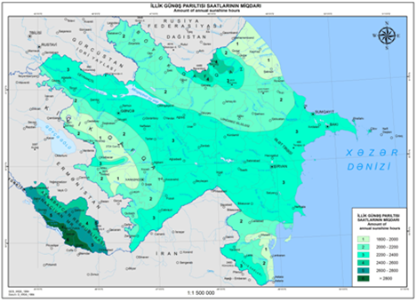 | Figure 1. Amount of annual sunshine hours |
 | Figure 2. Amount of non sunny days a year |
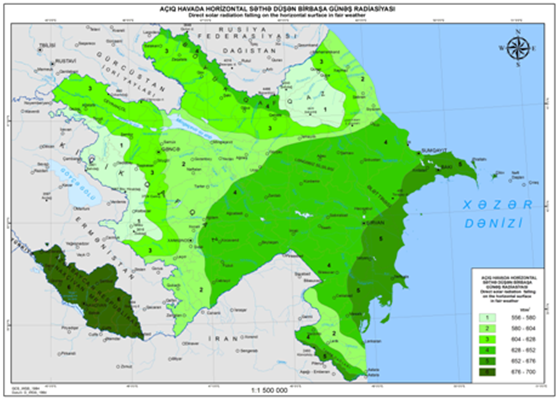 | Figure 3. Direct solar radiation falling on the horizontal surface in fair weather |
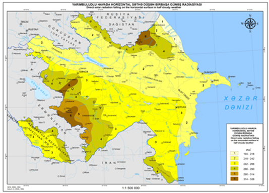 | Figure 4. Direct solar radiation falling on the horizontal surface in half cloudy weather |
 | Figure 5. Diffuse solar radiation in fair weather |
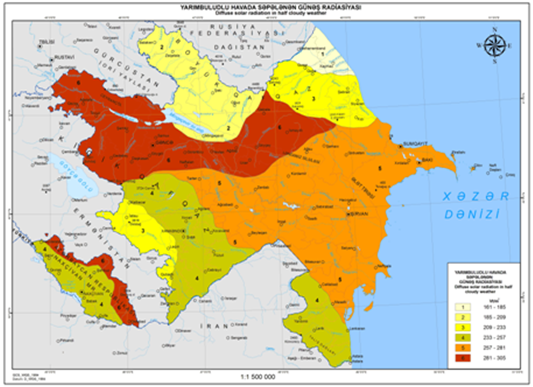 | Figure 6. Diffuse solar radiation in half cloudy weather |
3.3. Total and Albedo Solar Radiation Maps
 | Figure 7. Total solar radiation in fair weather |
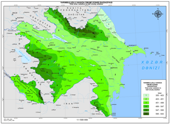 | Figure 8. Total solar radiation in half cloudy weather |
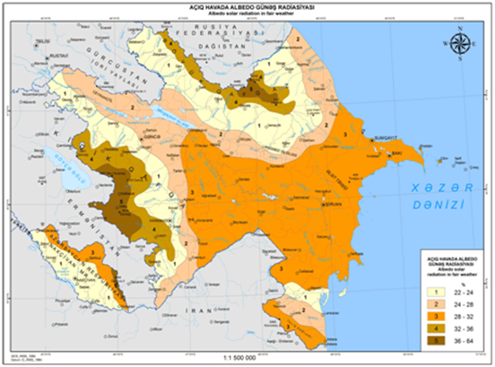 | Figure 9. Albedo solar radiation in fair weather |
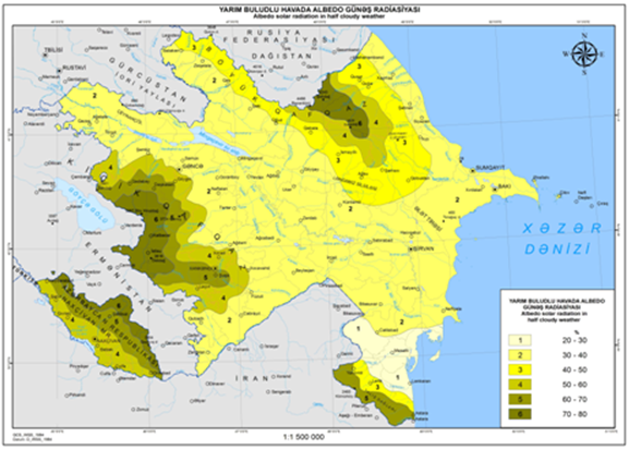 | Figure 10. Albedo solar radiation in half cloudy weather |
4. Discussion and Conclusions
- All maps were established on 1:1500 000 scale in Arcgis and Arcview programs. The developed maps are so important for the energy sector of the Republic. According to the decree signed by the president of Azerbaijan Republic these maps are to be included to the Azerbaijan National Atlas within the energy potential sector.
 Abstract
 Reference
 Full-Text PDF
 Full-text HTML