-
Paper Information
- Paper Submission
-
Journal Information
- About This Journal
- Editorial Board
- Current Issue
- Archive
- Author Guidelines
- Contact Us
World Environment
p-ISSN: 2163-1573 e-ISSN: 2163-1581
2023; 13(1): 1-8
doi:10.5923/j.env.20231301.01
Received: Jan. 2, 2023; Accepted: Feb. 10, 2023; Published: Apr. 27, 2023

Morphometric Analysis of Delta River Niger Basin in Nigeria Using Geospatial Approach
 Abstract
 Reference
 Full-Text PDF
 Full-text HTML
Ahuchaogu Udo E.1, Ojinnaka Oliver C.2, Akajiaku C. Chukwuocha1, Duru Uchenna U.1, Okoroji Anthony C.1
1Department of Surveying and Geo-Informatics Federal University of Technology Owerri
2Department of Geo-Informatics, and Surveying, University of Nigeria, Enugu Campus
Correspondence to: Ahuchaogu Udo E., Department of Surveying and Geo-Informatics Federal University of Technology Owerri.
| Email: |  |
Copyright © 2023 The Author(s). Published by Scientific & Academic Publishing.
This work is licensed under the Creative Commons Attribution International License (CC BY).
http://creativecommons.org/licenses/by/4.0/

In Delta state, series of water related disaster abound and this requires the use of state- of- the- art technologies to monitor so as to sustain the environments. Therefore, the aim of this paper is to demonstrate the potential of Remote Sensing (RS) and Geographic Information System (GIS) techniques in characterization of Morphometric attributes of Delta River Niger basin in Nigeria. Basic terrain and hydrological parameters such as slope aspect, 3-D Landscape, sub-catchments, flow direction, channel networks, drainage density, stream orders, stream frequency etc. have been processed using Advance space borne thermal emission and reflection Data (ASTER DEM) in GIS environment. Ground truthing and accuracy assessment has been carried out to ensure the reliability of the result. Based on Strahler’s method of stream ordering, the river basin is designated as 4th order basin, with 1st order streams mostly dominating. The overall stream network revealed a hierarchy of 1st, 2nd, 3rd order streams with river Niger positioned as 4th order streams in the hierarchy. This study reveals a total number of 123 streams draining an area of 17530 square kilometers of land. The total sum of the lengths of the streams and rivers measured 2907.33 kilometers giving rises to a drainage density of 0.1659km-1. It further revealed that there are ninety-six (96) first order streams, twenty (20) second order streams and seven (7) third order streams within the basin. Further investigation revealed that the basin has circulatory ratio of 0.4, stream frequency of 7.017 x 10⁻³, Form factor of 0.154, basin length of 337.60km and bifurcation ratio between the range of 4.75 to 5.0. These digital derivatives are essential for the proper management of the river basin and also attest that Remote Sensing and GIS can be effectively utilized as a viable tool to study river basins and their associated morphometry.
Keywords: River Basin, Morphometry, Remote Sensing, GIS
Cite this paper: Ahuchaogu Udo E., Ojinnaka Oliver C., Akajiaku C. Chukwuocha, Duru Uchenna U., Okoroji Anthony C., Morphometric Analysis of Delta River Niger Basin in Nigeria Using Geospatial Approach, World Environment, Vol. 13 No. 1, 2023, pp. 1-8. doi: 10.5923/j.env.20231301.01.
Article Outline
1. Introduction
- In contemporary times, the pace of climatic changes is increasing in alarming rate and this requires the use of state-of- the-art technologies to monitor so as to sustain the environments. Conservation of natural resources is of prime importance for sustainable development and to mitigate the demand and supply gap between resources (Sangeetha et.al 2019). Geographical information system (GIS) and remote sensing technique has proved to be reliable in solving verities of problems in geographic space. In this study, attempt has been made to characterize morphometric attributes of Delta state river Niger basin using remote sensing and GIS. Morphometry is the measurement and mathematical analysis of the configuration of the earth’s surface, shape and dimension of its landforms (Clarke 1996; Agarwal 1998; Obi Reddy et al. 2002; Praveen et al 2017). Good understanding of morphometric attributes of a drainage basin is invaluable for watershed management. Watershed management is the process of formulating and carrying out a course of action involving manipulation of the natural system of watershed to achieve specified objectives (Amulya et al 2018). It includes all the activities taken for proper use of all land and water resources of a watershed for optimum production with minimum hazard to natural resources. Studies on river and stream ordering systems abound all over the world as a result of the relevance of water to the sustenance of life (Abiodun et’al 2018). Morphometric analysis of a drainage basin is a quantitative description of a basin and an important aspect to know the character of the basin (Strahler AN 1964). Morphometric parameters define the topographical, geological and hydrological condition of a basin (Angillieri 2012; Kabite and Gessesse 2018.; Madaviand Anshumali 2019), It is important in any hydrological investigation like assessment of ground and surface water potential, assessment of flood and erosion propensity, ground water management, basin management and environmental assessment (Praveen et al 2014). It is well established that the influence of drainage morphometry is very significant in understanding the landform processes, soil physical properties and erosional characteristics). Digital Elevation Model (DEM) in the field of GIS provides the three dimension evaluation of the earth surface. Advanced Space borne Thermal Emission and Reflection Radiometer (ASTER) and Shuttle Radar Topographic Mission (SRTM) provide the data of DEM and are very useful for hydrological analysis and extraction of stream network of a drainage basin (Sumantra 2016).
1.1. Study Area
- Delta state is one of the oils producing state in Nigeria located in the south-south geo-political zone in the region known as Niger Delta. It has a population of 4098391 comprising of 2074306 males and 2024085 females base on 2016 population census. The State presently cover a land mass of 17530km2 and is bounded in the North by Edo State, the east by Anambra state, south east by Bayelsa State. Geographically it is located between latitude 5° 00’ and 6° 30’ and between longitude 5° 00’ and 7° 00’. Delta State is generally low lying without remarkable hills and has a wide coastal belt interface with rivulets and streams which forms part of the Niger Delta. Nigeria comprised seven relief regions based on land units or common land form assemblage these are listed as follows; (a) the creeks and lagoons, (b) the Niger Delta, (c) the coasted plane, (d) the river basin trough, (e) the inselberg landscapes, (f) the Chad basin and (e) the eastern high lands. Delta state fall in the region a, b, and c. These regions are partly wetlands with estuarine of Benin Rivers, Escarvos River, Forcodaos river with river Niger Bifurcation draining larger part of the state. The presence of Raros, Focardos and Escarvos rivers and river Niger render delta state prone to high annual rainfall and the areas of high rainfall are the area high flood impact.
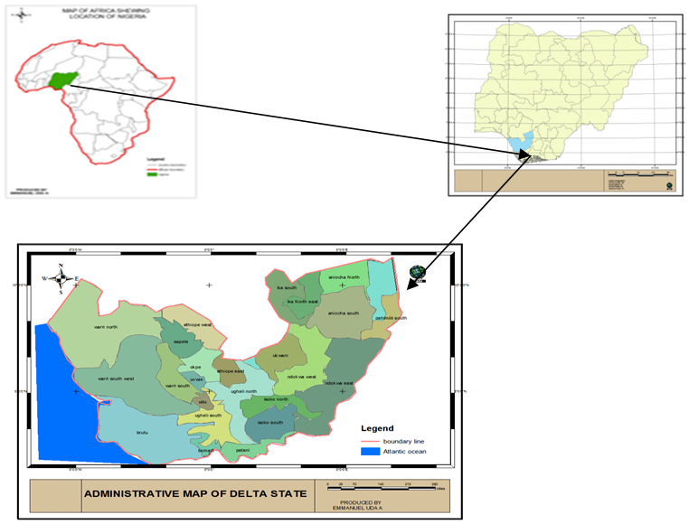 | Figure 1. Location Map of The Study Area |
2. Material and Methods
- In this study, Advance space borne thermal emission and reflection Data (ASTER DEM) of one arc second (30m resolution) covering the study area was utilized. This dataset is originally, georeferenced into the horizontal datum of WGS84 and then it is referenced into the vertical datum of EGM96 geoids. Other datasets include Catchment map of Nigeria, and political map of the catchment area. software used is Arc- GIS version 10.4.
2.1. Methodology
- Manual extraction of drainage network and assigning the stream order is a time taking tedious exercise. To overcome this problem, automatic extraction techniques have been used for evaluating the morphometric parameters of the basin, i.e., extraction of River basin/watershed boundary and extraction of drainage/stream network of Delta state River Niger basin. The Digital elevation model is the first input for morphometric analysis. The tiles of the elevation raster (DEM) have been mosaicked using data management function of Arc-tool box in ArcGIS 10.4 and the generated data was transformed from geographic coordinate system to projected coordinate system World Mercator. To ascertain compatibility, the catchment map of Nigeria, and political map of the catchment area were georeferenced to WGS1984 World Mercator. The shape-file of the basin was extracted from the Nigeria political catchment map through digitizing and was used to clip out the study area from the DEM to actual boundary limit and shape. The clipped raster was used for surface analysis, hydrological analysis, linear and areal aspects of morphometric analysis.
2.2. Extraction of Drainage Network
- The drainage network of the basin was extracted from series of geo-processing tools in hydrology extension of Arc GIS 10.4. The output of this method is a basis for extracting stream features. The depression in the DEM was filled using the fill tool and was used to create the flow direction grid of the Basin. Flow direction grid holds values in its cells that indicate the direction of the steepest descent from each cell. This value determines the direction water will flow from each cell based on the underlying topography of the landscape. Flow direction grid is fundamental to the generation of flow accumulation grid. Flow accumulation grid is important because it identifies cells of high flow where streams and channels are to be expected. In other wards each cell in the flow accumulation grid contains a value that is determined by the number of upstream cells flowing into it. The Flow Accumulation Grid was processed to create the Stream Definition Grid. A threshold of the volume of flow (number of accumulating cells) that defines a stream in the project area was set. This helped in proper definition of the stream segments. The idea here is that the grid cells that accumulate runoff from a specified number of cells are considered to be the stream (flow route) cells. Strahler’s system of classification designates a segment with no tributaries as a first-order stream. Where two first-order stream segments join, they form a second-order stream segment and so on. The sum of the length, and total number of the streams (linear aspect) were calculated with the help calculate geometry module of Arc GIS 10.4.
2.3. Drainage Density
- This is the ratio of total stream length in a given basin to the total area of the basin. It is a measure of how well or poorly watershed is drained by stream channels Horton (1932) reported that the value of the drainage density ranges from 0.93km-1 to 1.24 km-1 in the steep impervious area of the high precipitation region and zero for the permeable basin with high infiltration rate. Drainage density is related to various features of landscape dissection such as valley density, channel head source area, relief, climate and vegetation (Moglen et al. 1998; Praveen et al 2017), soil and rock properties (Kelson and Wells 1989; Praveen et al 2017). The area of the basin and the total length of the streams and rivers in the basin has been calculated using Calculate geometry module of ArcGIS10.4 and the drainage density has been calculated using the formula; Lu/A.
2.4. Circulatory Ratio (Rc)
- Miller (1953) appraised that circularity ratio is the ratio of the area of the basins to the area of circle having the same circumference as the perimeter of the basin. It is a dimensionless parameter which provides a quantitative index of the shape of the basin (Jha VC (1996). Circular basin has a maximum efficiency of the movement of runoff, whereas an elongated basin has the least efficiency. This parameter is very significant in forecasting drainage discharge, particularly in a time of the flood. In this study Circulatory ratio was computer using the formula; Rc = 4πA/P2.
2.5. Stream Frequency (Fs)
- Horton (1932) defined stream frequency as the ratio of total number of channels cumulated for all orders within a given drainage basin and the area of that drainage basin. Reddy et al. (2004) reported that low values of stream frequency (Fs) indicate presence of a permeable subsurface material and low relief. The area of Delta River Niger basin and the total number of streams and rivers in the basin have been measured using Calculate geometry tool in GIS environment. These datasets were combined to compute the drainage density of the basin using the formula; Fs = Nu/A.
2.6. Form Factor
- This is defined as the ratio of the basin area to the square of the basin length. It is dimensionless quantity which is used to describe the different shape of basin. The basins with high form factors portray high peak flows of shorter duration, whereas, elongated drainage basin with low form factors depicts lower peak flow of longer duration (R. E. Horton, 1945; Sayeed et al 2017). The value of the form factor varies from 0 (highly elongated shape) to the unity, i.e., 1 (perfect circular shape). In this study Form factor has been computed using the formula; Ff = A/L2.
2.7. Bifurcation Ratio (Rb)
- The Bifurcation ratio may be defined as the ratio between the numbers of stream segments of any given order to the number of the next higher order. If Rb of a river basin is low, there is a higher chance of flooding, as the water will be concentrated in one channel rather than spread out (Sayeed et al 2017). In line with the above definition, bifurcation ratio has been calculated using the formular; Rb = Nu/Nu+.
3. Result and Discussion
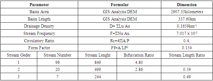
- In line with the purpose of this study, ASTER-DEM was used in GIS platform to characterize the morphometric attribute of Delta River Niger basin. Figure 2 is the drainage network of the basin and fig 3 is drainage order map of the basin. Figure 4 is sub-catchment map of the Basin and figure 5 is the Aspect map of the basin. Figure 6 is the slope map of the basin. Figure 7 is overlay analysis of flow vectors on 3-D surface model of the study area, Fig 8 A stack of hydro-terrain on 3-D surface of the study area. Table 1 is the morphometric attributes of the basin.
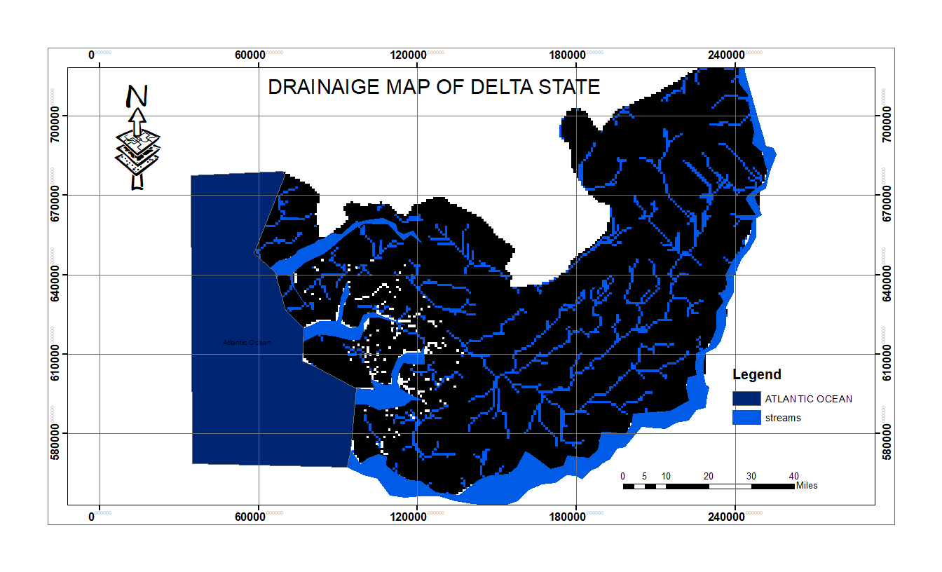 | Figure 2. Drainage map of the study area |
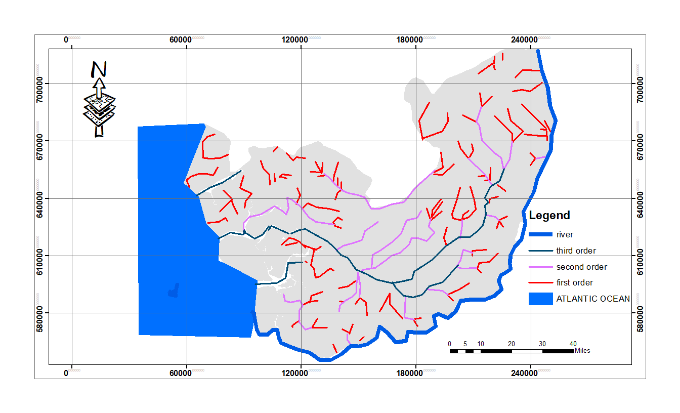 | Figure 3. Stream order map of the study area |
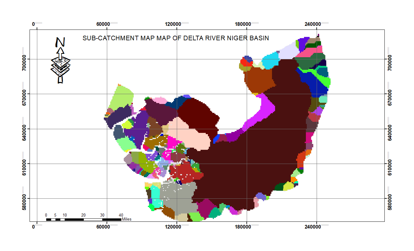 | Figure 4. Sub-catchment map of the study area |
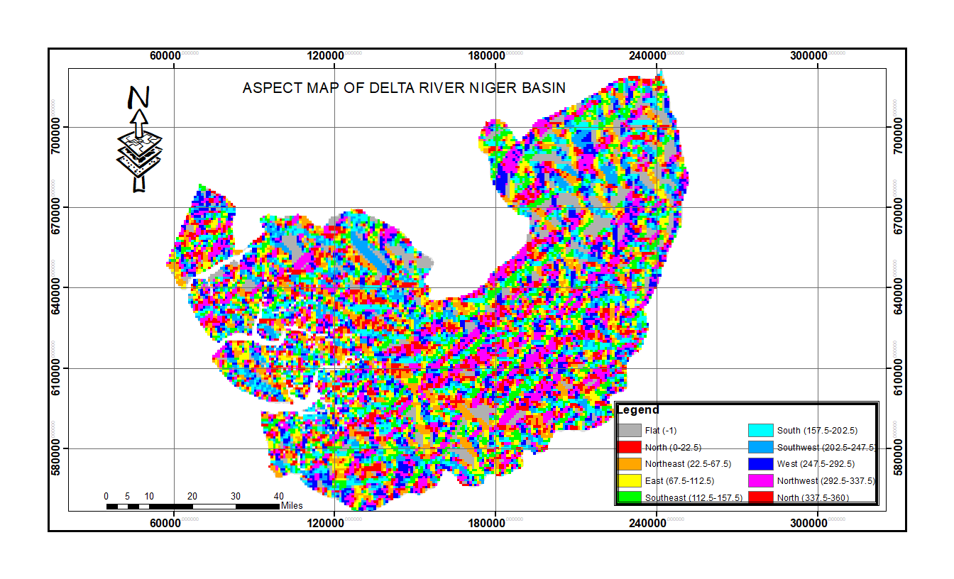 | Figure 5. Aspect map of the study area |
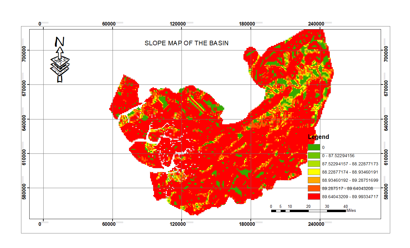 | Figure 6. Slope map of the study area |
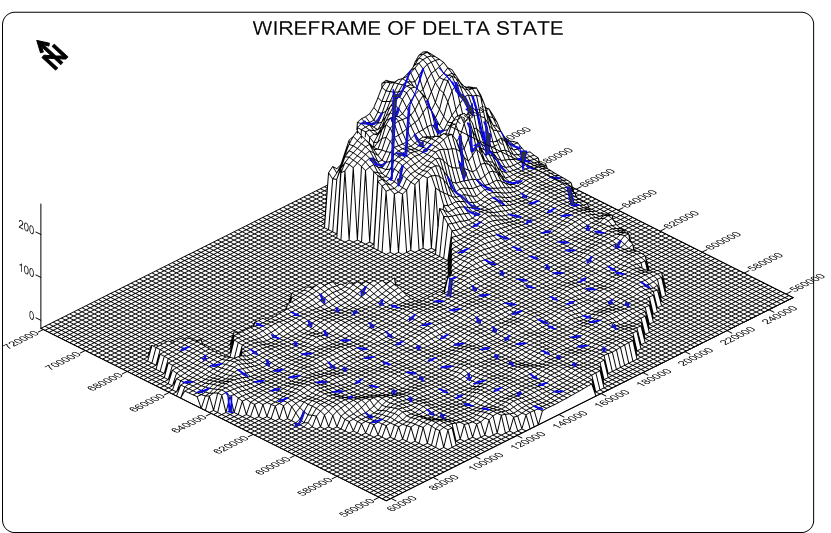 | Figure 7. Over Lay Analysis of Flow Vector And 3-D Surface Map Of The Study Area |
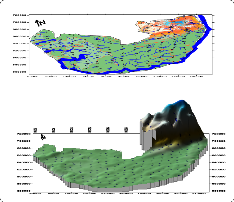 | Figure 8. A stack of hydro-terrain on 3-D surface of the study area |
|
3.1. Discussion of Results
- The drainage map (fig 2) and stream order map (fig 3) of the basin revealed dendritic pattern. Based on Strahler’s method of stream ordering, the river basin is designated as 4th order basin, with 1st order streams mostly dominating. The overall stream network revealed a hierarchy of 1st, 2nd, 3rd order streams with river Niger positioned as 4th order streams in the hierarchy. This study reveals a total number of 123 streams draining an area of 17530 square kilometers of land. The total sum of the lengths of the streams and rivers measured 2907.33kilometers giving rises to a drainage density of 0.1659km-1. It further revealed that there are ninety-six (96) first order streams, nineteen (20) second order streams and four (7) third order streams within the basin. Sub-catchment map (fig 4) is invaluable for investigation of source of stream pollution, this study reveals a total of 157 sub-catchment within the basin. The largest and smallest basin measures approximately 1 square kilometer and 7997 square kilometers respective.
3.2. Aspect and Slope
- Aspect (Fig 5) depicts the slope direction and is measured clockwise from 0° to 360°. This is a crucial step in hydrological modeling as the direction of flow will determine the ultimate destination of the water flowing across the surface of the land. The aspect of a slope is a very significant influential factor of its local climate because the sun’s rays are in the west at the hottest time of day in the afternoon, and so in most cases a west-facing slope will be warmer than sheltered east-facing slope. This can have major effects on the distribution of vegetation in the watershed (Praveen et al 2014). Slope at a point is calculated as the gradient of the plane formed by the vector connecting the left and right neighbors (run) and the vector connecting the upper and lower neighbors of the pixel (rise). The DEM data has been processed to slope map of the study area (fig 6b) using spatial analysis tool. Higher slope degree results in rapid runoff and increased erosion rate (potential soil loss) with less ground water recharge Potential. The degree of slope in delta river Niger basin varies from 0° to 90°.
3.3. 3-D Surface Analysis
- Fig 7 revealed 3-D surface model of the basin. The surface analysis revealed undulating high land on the northern part of the basin with the elevation decreasing sharply towards the southern part of the basin. It also shows surface runoff vectors moving towards the southern part following the landscape pattern. A stack of the hydro-terrain on 3-D surface (Fig 8) revealed that streams are more concentrated at the lower (southern part) and flat region of the basin. These attributes assist the hydro-analyst in identifying areas prone to flood and erosion, assessment of discharge potential of the basin, estimation of areas of good surface and underground water potentials. These are invaluable for watershed management. In other words, the attributes of the basin under investigation indicates that the lower part of the basin is of good surface and underground water potential. It is also exposed to extensive flooding during extreme climatic condition.
3.4. Drainage Density and Stream Frequency
- These parameters show how well a basin is drained by streams and can be used to assess the topographical and hydrological condition of the watershed. The drainage density and stream frequency of the basin are 0.1659km-1 and 7.017 x 10⁻³ respectively. These attributes indicate coarse drainage texture. This shows that the basin is made of permeable subsurface materials. These qualities coupled with circulatory ratio of 0,4 and form factor of 0.154 revealed that the basin is of low run off and erosion potential. Other attributes such as basin area, basin perimeter, basin length, stream number, stream length, stream length ratio and bifurcation ratio are summarized in table 1 above. These morphometric attributes are invaluable for watershed management in the study area.
4. Conclusions
- In contemporary times, the pace of climatic changes is increasing in alarming rate therefore the need to adopt the most reliable technologies to monitor and sustain our environments. Morphometric analysis of drainage system is prerequisite to watershed management. Morphometric descriptors represent the relatively simple approaches to describe the drainage basin processes. It is used to compare basin characteristics and enable understanding of geological geomorphic and hydrological history of the drainage basin. In this study, geospatial approach has been employed to evaluate quantitative attributes of Delta River Niger basin. It is inferred that the basin falls under 4th order basin and is dominated by lower order streams. Other morphometric attributes of the basin (table 1) suggest that it is made of permeable subsurface materials with low runoff and erosion potential. However, the lower part of the basin is exposed to short duration flooding during extreme weather condition due to good permeability of the soil. The quality of results and digital morphological derivatives from this study attests the reliability of GIS and remote sensing data in morphometric assessment of a river basin.