E. C. Merem1, Y. A. Twumasi2, J. Wesley1, D. Olagbegi1, M. Crisler1, C. Romorno1, M. Alsarari1, P. Isokpehi1, A. Hines3, G. S. Ochai4, E. Nwagboso5, S. Fageir6, S. Leggett7
1Department of Urban and Regional Planning, Jackson State University, 101 Capitol Center, Jackson, MS, USA
2Department of Urban Forestry and Natural Resources, Southern University, Baton Rouge, LA, USA
3Department of Public Policy and Administration, Jackson State University, 101 Capitol Center, Jackson, MS, USA
4African Development Bank, AfDB, 101 BP 1387 Avenue Joseph Anoma, Abidjan, AB 1, Ivory Coast
5Department of Political Science, Jackson State University, 1400 John R. Lynch Street, Jackson, MS, USA
6Department of Criminal Justice and Sociology, Jackson State University, 1400 John R. Lynch Street, Jackson, MS, USA
7Department of Behavioral and Environmental Health, Jackson State University, 350 Woodrow Wilson, Jackson, MS, USA
Correspondence to: E. C. Merem, Department of Urban and Regional Planning, Jackson State University, 101 Capitol Center, Jackson, MS, USA.
| Email: |  |
Copyright © 2020 The Author(s). Published by Scientific & Academic Publishing.
This work is licensed under the Creative Commons Attribution International License (CC BY).
http://creativecommons.org/licenses/by/4.0/

Abstract
Water resource access as an integral part of everyday life serves multiplicity of purposes from agriculture to the hydroelectric power needs of most areas. However, in the Nile Basin region where major water sources for nations pass through international boundaries, limited access to water and lack of it can be a source of economic, political and ecological conflicts. Accordingly, in the last several years, the complexities and processes involved in transboundary water use under the ambit of hydropolitics in the Nile Basin region, continue to stoke anxieties and tensions among the nations in their strategic relationships. Given the high stakes, occasional responses to addressing hydrological stress can sometimes involve unilateral investment in the latest advances in technology to extract water, recourse to negotiated settlements and multilateral accords. Conversely, unilateral responses to water insecurity in such a region when not properly negotiated often create uncertainties and distrust that threaten regional stability. Even in the face of such volatilities, nations that were once at odds in the past over water insecurity are resorting to negotiations instead of the drumbeats of war in the Nile Basin of Africa. This is compounded by rapid growth in population, the threats of climate change through recurrent drought amidst high propensity to instability and poverty. Having said that, very little exists in the literature on current state of water politics of the study area using a mixscale model of GIS and descriptive statistics. At the same time, there has been limited coverage on the scale of water use, the different uses, and the distribution patterns in the study area. To bridge that void, the study will focus on transboundary water use within the purview of hydropolitics along the Nile Basin with emphasis on the issues, trends, factors, impacts and efforts. While the paper used mixscale techniques of GIS and descriptive statistics to analyze the trends. The results reveal notable disparity in hydrological parameters with evidence of water stress and abundance in various areas of the study area. For that, irrigation water use was more pronounced in the Northern nations of Egypt and Sudan coupled with cases of unmet water needs in the heavily populated places (Egypt and Ethiopia). Both nations experienced more cases of unmet water needs compared to the countries in the South. Notwithstanding, the higher volumes of rainfall and more per capita fresh water in the Sub Saharan Africa portion, than the North African zone, areas classified as water bodies and wetlands declined substantially throughout the Nile Basin. This could lead to depletion and growing anxiety. Considering the role of socio-economic, political and physical elements in all these, the paper proffered solutions ranging from education, conservation, mediation and negotiated settlements as well as effective policies, and mutually binding agreements among nations in the region on water use.
Keywords:
Hydropolitics, Water stress, Transboundary issues, Conflicts, GIS, Nile basin of Africa, Factors
Cite this paper: E. C. Merem, Y. A. Twumasi, J. Wesley, D. Olagbegi, M. Crisler, C. Romorno, M. Alsarari, P. Isokpehi, A. Hines, G. S. Ochai, E. Nwagboso, S. Fageir, S. Leggett, Issues in Transboundary Water Use in the River Nile Basin Area of Africa, World Environment, Vol. 10 No. 2, 2020, pp. 27-44. doi: 10.5923/j.env.20201002.01.
1. Introduction
Water resource access as an integral part of everyday life serves multiplicity of purposes from agriculture to the hydroelectric power needs of most areas [1,2,3,4,5]. No regional goals of water security are feasible in the absence of jointly negotiated water agreements to improve access and quality in a transboundary setting where users share common sources [6,7,9,8,9,10,11,12,13]. In the Nile Basin [14], the major problems related to water security are scarcity and temporal variability of rainfall [15,16,17,18,19, 20,21,22]. Water scarcity obstructs proper hygiene and sanitation, limits irrigation, impedes production of food crops, cash crops, livestock development as well as hydropower production. In fact, the water security situation in the Horn of Africa side remains far bigger than several areas in Africa [18,23]. With agriculture as the primary economic activity in all riparian nations of the Nile Basin, in Egypt and Sudan, irrigated farming is the dominant subsector and, in both areas, over 5.5 million hectares of land are under irrigation, with future intent to add more 4.9 million ha [24]. The other riparian nations lack the potentials for irrigation in the basin and rely solely on rain-fed farming. This paves the way for the dominance of Egypt in that sector. Today, colonial era treaties granting absolute rights to Nile waters to Egypt at the expense of upstream nations in East Africa are leaving many in the region with limited use and contributing to water tensions in the zone [25,26]. Egypt and Ethiopia have clashed over water from the River Nile for years [27]. The river which originates in Ethiopia but ends in Egypt, creates a naturally contentious relationship [28]. Given Egypt’s current level of aridity, it can run out of water by 2025 [28,29]. Thus, in the region, the rising shortage and destruction of water assets pose extreme danger to the welfare of communities [30]. With that, the growing population in the zone rose significantly in the last five decades and remains on track to further increase with more water stress [31,32,33,23,34,35]. At the same time, farmers in the zone require extra water to grow more food for teeming consumers and this is resulting in the search for large swaths of arable land with further encroachments on forest habitats and grasslands to boost farm output. Given the steady growth in pastoral activities, the stress on grassland areas and water demands has intensified. The rising pressure on fertile soil and land suitable for irrigation in the zone appears linked to mounting global demands for farm produces and different forms of energy from financiers throughout the global marketplace interested in financing agri-business operations in Sudan, Kenya, Uganda and Ethiopia. In the face of ineffective land and water conservation action plans, these levels of stress on the ecosystem results in the decline of transboundary water resources [24]. As some of the nations in the region live on water levels below critical thresholds of 1,700 cubic meters per individual annually. In 2010, the Horn of Africa side of the Basin endured the gravest level of aridity in six decades that killed 260,000 people of which 50% of the victims were mostly kids trapped in water stressed areas prone to hydrological insecurity [36]. Such conditions in the Nile Basin must be analyzed to fully gauge the patterns of usage among the nations despite the tense regional history over water use [24]. As the biggest users of water, Egypt and Sudan are so reliant on river waters of the Nile that their daily activities hinge on it [24]. In the last decades, these neighboring nations have embarked on the design of mega dams and water projects, eager to contain the threats of famine and storms that have long shaped their past in water use in the region. During the period 1929, Egypt as key benefactor of the Anglo Egyptian treaty got the largest volume of water from the Nile river estimated at 48-50 billion cubic meters (BCM) of water, while neighboring Sudan got only 4 BCM [37]. In the process, Egypt was given the powers to veto any upstream water projects in Sub Saharan African side of the basin. From there on, both Sudan and Egypt initiated another treaty in 1959 which further augmented each nation’s hold on the water use, but still preserved the preferential status of Egypt. The other countries in the basin from Eritrea to Tanzania were no party to the treaty because they were not independent then. While the treaty also allowed for the design of Aswan High Dam in 1971. It so negatively affected the upriver states that they saw no obligation to abide by treaties signed for them by Britain. So, in 2010, six upstream countries (Ethiopia, Kenya, Uganda, Rwanda, Burundi, and Tanzania) signed a Cooperative Framework Agreement seeking more water shares which Egypt and Sudan rejected [29,12]. With time, Ethiopia began planning for dams on the Blue Nile which culminated in the $4.2 billion Grand Ethiopian Renaissance Dam (GERD) in 2015 [38]. Even though the dam is expected to generate 6,000 MW of power, it now epitomizes a novel beginning in lengthy agelong dispute pertaining to proprietorship over the waters of the Nile [38]. Egypt expressed worries that a hasty filling of the dam, can impede the water outflow the nation relies on as 60% of Egypt’s water originates from the Blue Nile. Even at that, Egypt and Ethiopia put their differences aside to allow the design of the GERD on the Nile river with a deal that strives to ensure fair water access and power supply for neighbors. The nature of such hydropolitics exemplifies the complex arenas of interactions among nations that share river basins [39,40,41,42]. While this complexity remains compounded by degradation and depletion of regional waters, population stress and climate change pressures. The absence of hydropolitical cooperation in that setting extracts socio-economic, political and ecological costs from all players [40]. See Appendix A for more on the concept of hydropolitics. Having said that, very little exists in the literature on current scale and state of water usage and the ecological effects among the nations along the River Nile Basin of Africa overtime using a mixscale model of GIS and descriptive statistics. To bridge that void in the literature, this study assesses water use trends in the Nile basin of Africa with emphasis on the issues, trends, factors, impacts and efforts. In terms of methods, the paper draws from secondary data, mixscale techniques of GIS and descriptive statistics to analyze the trends under 4 objectives. The first and second objectives involves the contribution to the literature on transboundary use of water and to examine the current issues in regional management. While the third and fourth aims are centered on the development of decision support tools for the planning of shared resources and to identify strategies for nations in transboundary hydrological settings. The organization of the research covers five parts made up of introduction, methods, results, discussions and conclusions.
2. Methods and Materials
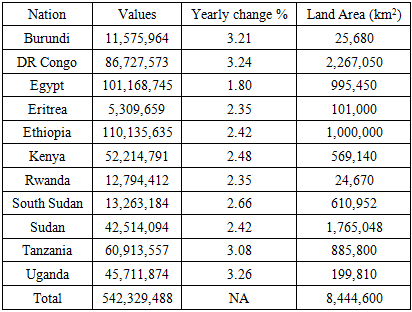
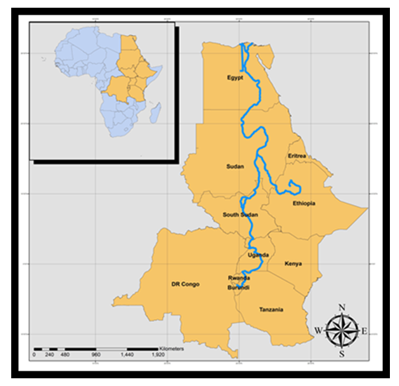
The Nile River Basin an area of over 3 million km², [4,7,11,43,24] is geographically shared by eleven countries in Africa: Burundi, Democratic Rep. of Congo, Egypt, Eritrea, Ethiopia, Kenya, Rwanda, Sudan, South Sudan, Tanzania and Uganda (Fig 1 and Table 1) [44,45,46,14]. The Nile River (Fig 1) in the zone is the longest river in the world with a length estimated at 6,825 km2 from its source in Lake Victoria to the Mediterranean Sea. The Basin has over 257-542 million people in the area; 54% of the total population of the 11 countries and it is expected to grow to 591 million by 2025 at an average rate of 2.5-3.0% (Table 1). At that rate, the Nile Basin’s population is expected to double in the next 25 years [4,7,11]. This increase will continue to deplete the region’s already scarce water supplies because of the rising demands from agriculture, industry and domestic use [24]. Thus, water is increasingly becoming a scarce commodity in that part of the world [5]. On the drainage systems of the Basin, the Nile has two main tributaries; the White Nile with its upstream catchments fed by rivers originating in Burundi and in Rwanda and the Blue Nile originating in Ethiopia, both of which have very distinct hydrologic regimes (Fig 2.2). Whereas the Nile waters come from rainfall on the Ethiopian highlands [29] and the catchment areas of the equatorial lakes. The Northern part of the basin lacks rainfall in the summer, while the Southern area has heavy rains during the summer months [24]. Over the decades, the Ethiopian highlands have had a large annual rainfall surplus, whereas all other regions (except for large parts of Uganda) faced significant annual rainfall deficits. This is largely due to the variabilities in the existing climate, environmental stress, [47,48], the lack of skills and the inability of institutional infrastructure in utilizing technological innovations in overcoming water insecurity. Table 1. The Population Distribution, Yearly Change and Land Area, 2019
 |
| |
|
 | Figure 1. The Study Area, Nile River Basin |
Just as the ecological system is unique, it contains several varied landscapes, with high mountains, tropical forests, woodlands, lakes, savannas, wetlands, arid lands and deserts. In the riparian communities therein, many people rely heavily on the exploitation of the environment and water resources for their livelihoods and agriculture ranks high as the primary economic activity among countries of the Nile Basin amidst the design of water infrastructure and tensions [48,49]. Nevertheless, most of the countries of the Nile Basin lack the basic water infrastructures and human resources that are usually needed to implement and maintain large development projects like the GERD [48]. Accordingly, Egypt has come to rely on the underutilization of water by other Nile Basin countries, such as Sudan, Ethiopia, and Uganda alongside others in the Sub-Saharan Africa side of the Basin, because of low levels of economic development in those areas in the past and a regional water treaty built on unequal distribution of the resource [24, 50]. To put Egypt’s situation into context, one must realize that, it is one of the most water-dependent countries in the world where roughly 97% of its freshwater falls as rain outside its border with very little groundwater and slight rainfall [24,48]. Besides that, Egypt is also one of the driest and sunniest countries in the world in which almost two-thirds of the water originates in the Ethiopian Highlands along the Blue Nile, one of the Nile River’s two main tributaries [48]. Said that, the Nile region is susceptible to climatic hazards and had been affected by serious droughts and violent floods like those of 1963-2007 particularly in East Africa and Ethiopia [16,48]. Accordingly, the Nile river has had a major effect on the interstate politics of the region as it is the only reliable source of renewable water supplies in the region [49,50,51,52].
2.1. Method Used
The research uses a mix scale approach involving descriptive statistics and secondary data connected to GIS to analyze the transboundary water resource issues in the River Nile Basin of Africa. The spatial information for the enquiry was obtained from several agencies consisting of the United Nations Economic Commission For Africa (UNECA), The United States Agency For International Department (USAID), the African Union (AU), The Inter-governmental Panel for Climate Change (IPCC), the World Bank and Aquastat FAO's Information System on Water and Agriculture. Other sources of spatial data originate from the UK Center for Ecology and Hydrology, the United Nations Environment Programme (UNEP), UNESCO, the Council of Ministers of Water Affairs of the Nile Basin, the Geological Society of America and Carnegie Endowment for International Peace. Additionally, the International Rivers, International Association of Hydrological Sciences, the United Nations Population Division, Water Resources Atlas for the Nile Basin, African conservation telegraph and the Uganda Ministry of Energy and Mineral Development also furnished other information needed in the research. Largely, most of water use or hydrological parameters like irrigation use, irrigated area and fresh water distribution pertinent to the region and various countries were found from the national and state government archives of the North and East Africa and Horn of Africa, along with the Okavango River Basin Water Commission as the Egyptian Ministry of Irrigation and Water Resources and the Nile Basin Initiative Secretariat supplied extra info needed in some of the periods.On the one hand, the ESA GlobCover project, Nile Basin Initiative Secretariat, Eastern Nile Technical Regional Office and the Swedish International Development Co-operation Agency (SIDA) provided the additional secondary data on the numbers, quantities, trends, deficits in water budget and the other categories. On the other, the International Water Management Institute, National Environment research Council and the Swedish International Development Cooperation Agency (SIDA) and the UNEP-DHI Centre for Water offered the assistance on historical data and other valuable information on hydrological assets on the primary surface and ground water budgets pertaining to the region. Concerning the remaining data needs, the Water Information Program (WIP), The Ethiopian Institute of Water Resources, The European Union and Institute for Environmental Security were respectively critical in the procurement of information on the number of usages, and physical data highlighting withdrawal, changes and consumption. In a similar vein, the Cooperation in International Waters in Africa, Stockholm International Water Institute, World Commission on Dams, Lake Victoria Basin Commission, Greater Horn of Africa Rainwater Partnership and the World Metrological Organization remained instrumental in the provision of other relevant information. Give that the boundaries stayed the same and unchanged with the exception of the addition of South Sudan from the original nation of Sudan, the regional and state, county and federal geographic identifier codes of the countries were used to geo-code the info contained in the data sets. This information was processed and analyzed with basic descriptive statistics, and GIS with attention paid to the temporal-spatial trends at the state, regional and watershed levels in the River Nile Basin of Africa.
2.2. Stage 1: Identification of Variables, Data Gathering and Study Design
The preliminary phase in this research started with the identification of variables needed to assess the extent of transboundary water use and trends at the regional and national levels from 1990 to 2019. The variables consists of socio-economic and environmental and hydrological data made up of areas of nations within the Nile Basin, estimated total area (km2), area in the Nile Basin (km2), % of total basin area, % of total country area, access to potable water, estimated % of urban population using improved drinking water facilities, and the estimated % of rural population using improved drinking water facilities. The others consist of MDGs targets on water, renewable international freshwater per capita, land cover classes, land cover percentage of change, land cover change by size or area, forest, shrubs, grasslands, cultivated area/agriculture, wetlands, bare areas and water bodies, sub-basin area and area of various water bodies. Added to that are the population estimates, population growth rates, rural population growth rates, urban population growth rates (%), mean monthly rainfall, average country rainfall (mm/yr.), water withdrawal for irrigation, actual irrigation water withdrawal, harvested irrigated area in Km2, proportion of irrigated areas, met and unmet water levels by nations. These variables as mentioned earlier were derived from secondary sources made up of government documents, newsletters and other documents from NGOs. This process was followed by the design of data matrices for socio-economic and land use (environmental) variables covering the census periods from 1990, 2000 to 2012, 2015 to 2019. The design of spatial data for the GIS analysis required the delineation of country boundary lines within the study area as well. Given that the official boundary lines between the 11 nations remained slightly the same, a common geographic identifier code was assigned to each of the area units for analytical coherency.
2.3. Stage 2: Data Analysis and GIS Mapping
In the second stage, descriptive statistics and spatial analysis were employed to transform the original socio-economic and ecological data into relative measures (percentages, ratios and rates). This process generated the parameters for establishing, the extent of water consumption, withdrawals, land cover change, irrigated land size, irrigation water withdrawal, rainfall volume and total basin area. The other variables covered in the analysis includes the population access to drinkable water by category served, the volume of fresh water flow, the sources of water consumed and the changes in water bodies, and wetlands precipitated by over use of water and the trends across the Nile River Basin for each of the eleven countries through measurement and comparisons overtime. Since the spatial units of analysis consist of various nations, regions, shorelines, and counties and the boundary and locations where the over extraction of water thrived, this approach allows the detection of change and the extent of usage. With that, the tabular info or index highlights the actual frequency and impacts, water depletion and the intensity of consumption and the trends as well as the ecological and economic costs. The remaining steps involve spatial analysis and output (maps-tables-text) covering the study period, using Arc GIS 10.4 and SPSS 20.0. With spatial units of analysis covered in the eleven countries (Figure 1), the study area map indicates boundary limits of the units and their geographic locations. The outputs for each country were not only mapped and compared across time, but the geographic data for the units which covered boundaries, also includes ecological data of land cover files and paper and digital maps from 2000 -2011.This process helped show the spatial evolution of location of various levels of usage, and the trends, the ensuing socio-economic and environmental impacts, ecological degradation as well as changes in other variables and factors driving the overuse of transboundary water and impacts in the study area. Having said that, efforts were also made to accommodate the insertion of the Republic of South Sudan into the regional spatial mix. This came with limited adjustment in the actual spatial data design given the obvious proximity to the Nile River Basin and various natural and geographic features that are germane to the enquiry herein.
3. The Results
This section of the paper presents temporal and spatial assessment of water use in the study area. There is an opening emphasis on the analysis of water withdrawal for irrigation in the Nile Basin and access to potable water facilities. The other portions highlight renewable international fresh water, rain fall distribution and landcover changes. This is followed by other aspects of the section comprising of an impact assessment, GIS mappings, and the identification of the factors driving water issues and use in the zone and the present initiatives.
3.1. Water Withdrawal for Irrigation in the Nile Basin
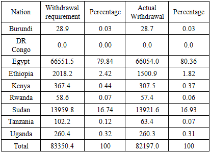
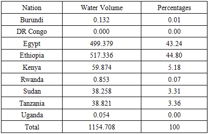
In terms of the amount of water withdrawal requirements and the actual withdrawal for irrigation in the River Nile Basin of Africa, of the listed nations, the two North African countries most notably Egypt and Sudan remain the principal actors and largest consumers of the resource. With irrigation requirement and actual withdrawal volumes of 66551.5-66551.5 MCM set aside for Egypt, note that, the percentage equivalencies stood at much higher levels 79.84 to 80.36% respectively. Further into the core Nile area, Sudan’s water withdrawal for irrigation and the actual withdrawal level of 13959.8 MCM to 13921.6 MCM accounted for over 16% of all water destined to irrigation needs in the entire basin. As the data on the Table indicates, the water demands for irrigation among the other countries in the Nile Basin not only paled in comparison to the amounts extracted by Egypt and Sudan, but they were quite below the legitimate needs of those other countries as well. Aside from Ethiopia’s water requirement and actual extraction volumes of 2018.2-1500.9 MCM being 2.42 to 1.82%, the requirements and the actual consumption for the other sovereign nations in the region from Burundi, Kenya to Uganda remained very minuscule and less than 1% (Table 2). Even at that and given the disparity in withdrawal, the bigger nations of Ethiopia and Egypt still have notable unmet water demands of 499.379 to 517.336 MCM. Accordingly, they both combined for about 88% of the total unmet water needs in the zone (Table 3). Table 2. Water Withdrawal for Irrigation in the Nile Basin (MCM)
 |
| |
|
Table 3. Unmet Water Needs By Country Unmet Demand [MCM]
 |
| |
|
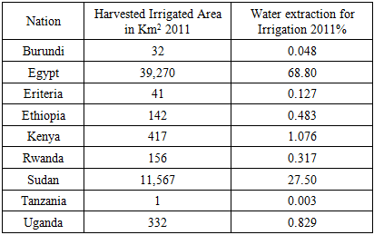
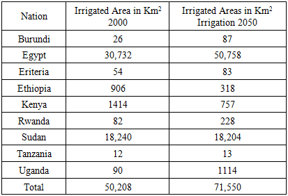
In the context of hydropolitics of irrigated areas by the nations in the Nile basin, see that the size of irrigation harvested areas and the rate of water extraction needed for water sprinkling are heavily dominated as usual by the North African nations of Egypt and Sudan. Beginning in the fiscal year 2011, Egypt and Sudan had sizable areas estimated at 39,270km2 to 11,567 km2 under irrigation that were devoted to farming. The large swaths of irrigated areas in both North African countries far exceeds those in the upstream nations of Uganda, Kenya, Ethiopia and Rwanda. In these nations where harvested irrigated land ranged from 332-417 to 142-156 km2, their sizes fall below the areas set aside for Egypt and Sudan (Table 4). In a similar vein, the water extraction rates for the same purposes in irrigation listed on the table reflects the same patterns in distribution sizes with Egypt and Sudan accounting for 68.80-27.50% of the entire levels of water for the zone far ahead of the other nations as mentioned before. Even though East Africa’s irrigation capacity remains underutilized, in the 2050 projections, both Egypt and Sudan outpace the rest of the region by 30,732-50,758 km2 to 18,240 km2-18204km2 followed by a strong surge from Uganda from 90 km2 of irrigated areas to 1114 km2 (Table 5).Table 4. Irrigated Areas by Country
 |
| |
|
Table 5. Irrigated Areas by 2050
 |
| |
|
3.1.1. Access to Potable Water
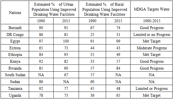
When it comes to access to potable water facilities level in the region during 1990 through 2015, Egypt held the top spot in both urban and rural categories in maximum values of (97% to 100%) 91 to 99% respectively along with Burundi which finished at 90 to 91 and 67 to 74 percentage points. Even at that, access to clean water remains an issue in large nations like the Democratic Republic of Congo where urban and rural water indicators varied by 86-81% and 25-31% compared to other countries. Among these nations, Ethiopia’s initial values of 84-93% on the urban sphere appeared somewhat encouraging in the periods 1990-2015, but it faded gradually as one steps into the rural areas in the same period. Between the other quartet of nations most notably Kenya, Rwanda, Tanzania, and Uganda, access to drinking water facilities did stabilize at the rate of 92-82, 85-90 percentage points in the first two nations coupled with 92-77% and 78 -73 for the remaining two other countries in the zone. Among these nations overall, the rural areas and the rural population still lag in terms of the percentage of people with access to potable water amenities between 1990-2015. When put in the context of MDGs, three nations Egypt, Uganda, and Burundi were classified as having met the targets while another three Burundi, Kenya and Rwanda were classified under the good progress category. Elsewhere, two other nations in East Africa; the Democratic Republic of Congo and Tanzania finished last in terms of limited or no progress pertaining to access to drinking water amenities from 1990 through 2015 (Table 6). Table 6. Access to Portable Water Use In the Nile River Basin Region
 |
| |
|
3.1.2. Renewable International Freshwater and Subbasin Areas
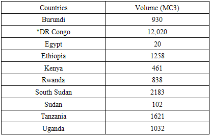
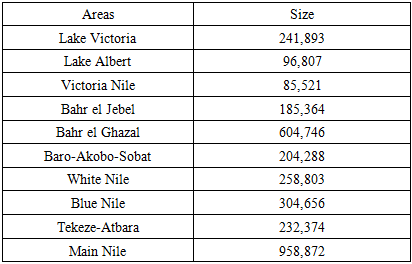
Of the countries in the region, the amount of renewable international fresh water per capita was more in the Democratic Republic of Congo with 12,020 MC3 than the other countries. For Egypt, renewable international fresh water of 20 MC3 appears lower compared to the abundance in a quartet of countries (Ethiopia, South Sudan, Tanzania and Uganda). The available international freshwater resource volume in these nations measured in the thousands stood at 1,258-2,183 to 1,621-1,032 MC3 respectively. Those other countries in the Horn of Africa where the international freshwater deposits per capita finished in the high and low hundreds (930-461, 838-102) includes Burundi, Kenya, Rwanda and Sudan (Table 7). Knowing fully well the significance of the volume of water assets in the area, the sub-basin areas as distributed in various regions offers some interesting perspectives. The first three subbasins cover an estimated area of 241,893km2, 96,807km2 to 85,521 km2. Worthy of note in that category of basins are Lakes Victoria and Albert and Victoria Nile located outside of the core North African zone. Further into North and North East Africa around South Sudan, Sudan and Ethiopia are additional group of sub basins with much larger sizes estimated in the hundreds of thousands (185,364 km2, 604,746km2 to 204,288 km2). These basins are Bahr el Jebel, Bahr el Ghazal and Baro-Akobo-Sobat and Tekeze-Atbara. The last three subbasins encompass the White, Blue and main Nile with basin areas in the order of 258,803km2, 304,656 km2 to 958,872 km2 (Table 8). Table 7. Renewable International Freshwater Per Capita
 |
| |
|
Table 8. Sub-basin Water Areas (Km2)
 |
| |
|
3.1.3. Rainfall Distribution and Changes in Water Areas
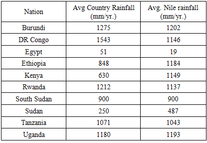
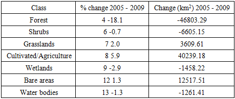
In the face of changing climatic variability, the rain fall distribution volumes among the countries in the Horn of Africa and Nile Basin also buttresses the extent of the water situation facing these areas sometimes in terms of deficits and abundance or surplus. Looking at the monthly water distribution patterns, both Burundi and the Democratic Republic appear to have the highest average levels. This consists of 1275 -1543 mm which is above the Nile average during the periods 2000-2012.This is higher than the precipitation levels of 51 to 19mm/yr for Egypt in the same period. While the duo of neighboring nations (Ethiopia and Kenya) had rainfall levels of 848 to 630 mm/yr below the average Nile rain. Another trio of East African nations (Rwanda, Tanzania, Uganda) experienced rainfall events with the volumes estimated in the thousands (1,212, 1,071, 1,180 mm/yr) that are somewhat identical to the Nile average. Considering that elsewhere, both South Sudan and Sudan saw different monthly rainfall distribution levels of 900 to 250 mm/yr). The South Sudan’s levels were same as the Nile average as Sudan fell below that threshold (Table 9). Regarding land cover changes in the region from 2005-2009, water bodies ‘percentage change ranged from 13 to 1.3 representing about -1,261.41 km in lost water areas. Even though the same patterns hold for wetlands and forest land areas. Land devoted to agriculture surged in the same periods (Table 10). See the Table in Appendix B for more.Table 9. Mean Monthly Rainfall Distribution by Country 2000-2012
 |
| |
|
3.2. Impact Assessment
There are widespread effects of shared waters in the Nile River Basin. These impacts come with socio-economic, health and ecological implications that are evaluated sequentially in the paragraphs below
3.2.1. Economic, Political Disputes and Regional Tensions
Looking at the fiscal impacts of transboundary water sharing issues, in the study area, it seems clear that, across the Horn of Africa side of the zone, where millions have been hit by the severe El Niño-related drought. The region is among those areas projected to take a big hit to Gross Domestic Product (GDP) by 2050 because of the threats of water scarcity [53]. In light of that, as we step further in the later part of the century, by 2050, the growing needs that are crucial for the development of cities and the agricultural sector with put further strain on water access by shortening the supplies in the River Nile Basin. This could worsen shortages across the zone by prompting further conflict and migration of people to other areas. Potential disputes over shared rivers do arise when neighboring nations fear that the damages from huge water diversions come at their expense. Certainly, the unilateral use of common water assets often viewed with suspicion for generations, fuels the drumbeats of war and threatens regional stability as witnessed in the 1960s, 1970s, 1980s and 2000s in the region. There is the danger of unwanted competition over the misuse of scarce water to settle cheap regional scores. In such settings, the demands of water thirsty agricultural practices in North of the Nile Basin in Africa has for decades overlooked the rights to access and sovereignty of upstream nations in the Sub Saharan portion of the zone. Such endless recourse to ambitious water infrastructure through huge dams to boost development using hydro power can entrap nations like Egypt and Sudan into far bigger issues like population explosions and unmanaged growth. The public demand for new amenities heavily reliant on water under such circumstances can threaten the grip on power by the political regimes in those nations.
3.2.2. Health Costs
The alarming rise of malaria in the Horn of Africa has direct links to the numerous dams and reservoirs built to ward off water scarcity. The Koka reservoir built in 1961 in Ethiopia and the biggest mega dam in the nation remains a case in point that spurred the outbreak of health epidemics in one of the countries in the region. In the country, there is often a spike in malaria cases from mid-September to mid-November, after the heavy rainy season in the Koka dam region. While in the Horn of Africa side of the study area, increasing scarcity and degradation of water sources by diversions seriously threatens public health. There exists a much larger danger in the occurrence of plasmodium falciparum diseases within the localities residing around 3km distance within the dam. Many known cases of cerebral malaria begin with high fever, seizures, coma and related neural warning signs requiring accelerated and precise action to avoid the loss of life. Seeing that Koka reservoir is situated within 100 km from Addis Ababa around the Rift Valley. The residents who typically leave in deplorable conditions with inadequate shelters made of shacks are vulnerable to the spread of mosquito induced sicknesses in the absence of protective napping shields like bed nettings. Based on the costs, the dam management does not assume any faults regarding control over the containment of malaria epidemic. This coincides with the absence of any protective water level handling measures in the dam. In its place, the power lies in the hands of public hygiene bodies under which the malaria eradication approach rests solely on the applications of DDT/malathion on farms as part of the treatment measures.
3.2.3. Ecological Effects
There are also the problems of evaporation, sedimentation and cases of limited fish catches in adjacent rivers based on experiences from the Aswan Dam in Egypt. In other places, collapsed dams and flooding from them have inflicted serious damages on ecosystems. Aside from the high level of salinity from soil, rocks and surrounding areas often transported across adjoining rivers. Egypt overuses its allotted water and suffers from insufficiency in water supply due to the rising demands. Even at that, the population of Egypt has been increasing and it is anticipated to jump up to 140 million by 2050. As the population increases, demands for water needed to sustain the hydrological security of the country will accelerate with notable impacts. In the face of those challenges, Ethiopia’s construction of the Grand Ethiopian Renaissance Dam (GERD) which is expected to produce electricity for Ethiopia and others has been greeted with deep reservations from Egypt. Egypt objects to the project by noting that the construction of the dam might lead to the loss of 3 billion cubic meters of the Nile water annually via evaporation and Ethiopia counters reminding all, that the evaporation of water from GERD amounts to barely 25% of the 12 billion cubic meters of water lost through Egypt’s Aswan dam yearly.
3.3. GIS Mapping and Spatial Analysis
Considering the changing hydrology in the Nile River basin area, the GIS mapping showcases the evolution of critical indicators that are crucial in the continuous access to water over time. It does provide a road map for delineating the spatial patterns of usage, availability and scarcity, the amenity that are vital in the distribution and the type of uses and others therein. Calibrating these indices in space comes with the symbols contained in the legends through different colors and scales. Being a measure of their attributes, presence and occurrences, the geo-spatial visuals epitomize many activities pertaining to the hydrology of the region under various rubrics. These includes the great divide as highlighted by the regional dichotomy of transboundary water sharing/agreement and host of other parameters like irrigation use and needs among the countries. For that, Figure 2 on water treaties buttresses the level of spatial divergence and convergence among the countries in the rejectionist camp and those that are supportive and receptive under different zones represented in blue and purple, light green and yellow colors in the map legend. From the info as conveyed in the map, note that the outlook of opposing nations to the cooperative framework for sharing water equitably outside of the provisions embedded in the defunct colonial treaty comprises of Egypt and Sudan. They are concentrated in blue areas in the Northern portion of study area coupled with Eritrea along the Horn of Africa. Further below on the Sub Saharan area, emerges the group of nations in the southern zone spread around central, North East, and East Africa receptive to and likely to sign the cooperative equitable water sharing agreements. While the first group depicted in light green on the left-hand, cover South Sudan, and the Democratic Republic of Congo, they share common inclinations towards an agreement. The other countries in yellow mostly East African neighbors of Uganda, Kenya, Tanzania, Burundi and Rwanda in solidarity with Ethiopia in the North East are all signatories to the water accord. Aside from the great divide among nations on the opposing camps of water politics in the region. The objections to the cooperative framework held firm in the North in blue, while clusters of areas receptive to the accord and the signatories remained in the Sub Saharan side (Figure 2).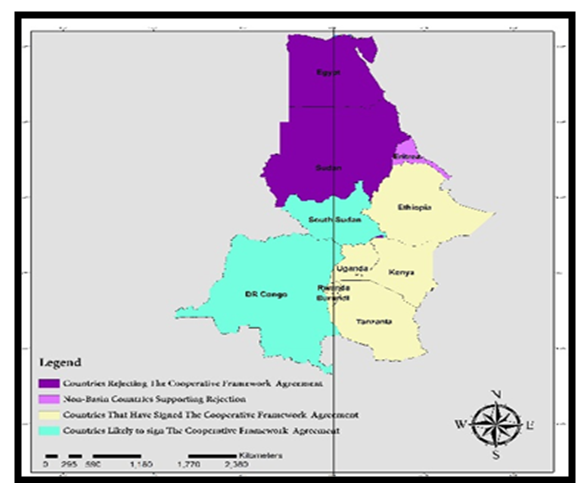 | Figure 2. Spatial Distribution of Water Agreements |
The spatial patterns of the flows in the tributaries beginning from southern zone of the map reflects the presence of large water bodies overly concentrated on the southern tip of the region. This reflects a gradual dispersal of transboundary water sharing indicators in various magnitudes coming out of East and Central Africa, the North East and the Horn of Africa. Since further flows pass up North with the activities in the Nile Basin side of the map dependent on the water movement out of South to the North. From the map, the gradual movement of the same body of water onto the white and Blue Nile and Nile River in the North epitomizes the rapid force of upstream hydrology in the zone (Figure 3).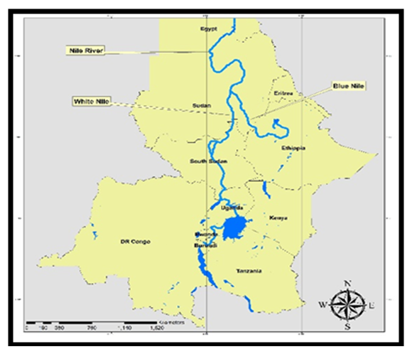 | Figure 3. Tributaries of The Nile River From South to North |
The spatial distribution of wealth and water infrastructure reflects the presence of a complex network of dams adjacent to major capitals and watersheds amidst the disparity in per capita wealth with Egypt ahead of the others even though it is not the source of the hydrological assets (Figure 4-6). Along the North East African region as the map shows, see the ongoing construction of the Grand Ethiopian Renaissance dam represented in red dot. Considering the significance and viability of the strategic water assets emanating from the Ethiopian Highlands and the amount that drains into the Nile River yearly. The sudden appearance in space of such a mega reservoir of immense proportion deemed the largest in Africa near to the borderlines with Sudan and South Sudan, adds to the list of dams in the region. Thus, it reaffirms the commitment of nations like Ethiopia in the basin to aggressively pursue investments aimed at the acquisition of the state-of-the-art infrastructure. This is essential in controlling and diverting Nile water towards regional and domestic use for agriculture, households and hydroelectricity amidst growing tensions with neighboring Egypt (Figure 5). Aside from being a flash point of hydro political tensions and an arc of crisis among the neighbors, these areas under the map bear the large presence of images of lakes in green color mostly along the Southern part in East and Central Africa with the dams denoted in red fully spread across the countries in the study area. Being fully concentrated along the North African side and the North East African part of the map especially the areas in Egypt, Sudan and Ethiopia along the Nile basin over time. The same spatial patterns that emerged in the distribution of Jebel and Aswan dams in the North African side also holds in the Central and East African part deep into the Sub-Saharan zone given the activities of dams like Koka in Ethiopia as well as Masinga and Hombolo in Kenya and Tanzania respectively (Figure 6). 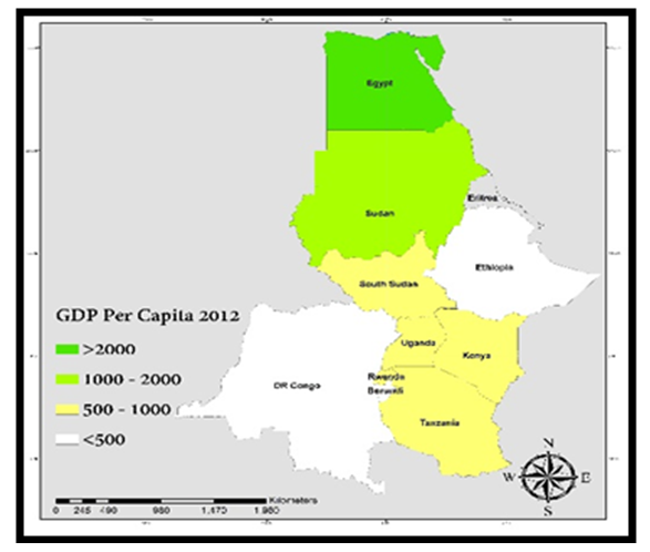 | Figure 4. Wealth Distribution and Fiscal Infrastructure |
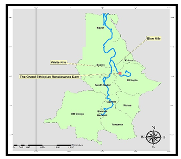 | Figure 5. The Grand Ethiopian Renaissance Dam |
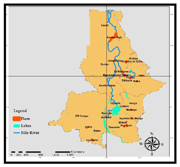 | Figure 6. The Locations of Water Infrastructure (Dams) |
In a water stressed region known for the seemingly gross disparity in the availability of irrigation capacity between the Northern and South states, the geography of the huge superiority enjoyed by Egypt and Sudan which is obvious, has widened over the years at a very significant pace. The evolving scales of irrigation activities over the areas as observed from 2011 and 2000 covered different hydrological indicators. This consists of the percentage of water extraction for irrigation, irrigated land areas and future projections in the length of irrigated areas in nine of the 11 nations in the study area. Aside from the anticipated changes in the size of irrigated areas likely to emerge across the Sub Saharan Africa lower South side to the North African zone by 2050 as manifested in a variety of colors under display (from high to low) (Figure 7,8,9). The assigned values of 27.7-68.8% to 18,240-30,732 km2 for 2011 and 2002 to the initial set of hydrological indicators shows the highest values in yellow and green held firm in the North African countries of Sudan and Egypt with the later accounting for the largest percentage points in the volume of water pumpage for irrigation and more land under sprinkled water. Because the level of disparity between North and South nations in irrigation in the study area was in full display in the maps. The Sub Saharan Africa side saw the lowest forms in irrigation capacity based on proportions of water usage and the presence of smaller swaths of irrigated land areas. These were dispersed throughout nations in the South from Ethiopia to Tanzania in the North East and East Africa. In the same areas, the projected size of irrigated areas in the upcoming three decades in 2050 among the countries again points to greater concentration estimated at 18,204-50,758 km2 up North in Egypt and Sudan in red and blue with most of the southern nations lagging in that category as Uganda and Kenya are expected to devote 757-1114 km2 areas to irrigation during that period. 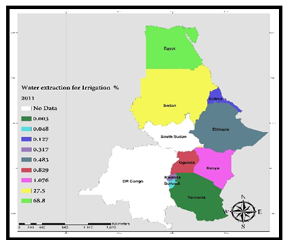 | Figure 7. Percent of Water extraction for Irrigation, 2011 |
 | Figure 8. Irrigated Area in Km2, 2000 |
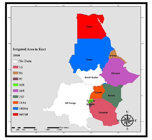 | Figure 9. Irrigated Areas in Km2, 2050 |
3.4. The Factors Fuelling Shared Water Use Crisis and Regional Efforts
The ongoing transboundary water issues among nations in the Nile Basin area of Africa does not operate in isolation. They are predicated on socio-economic and environmental factors. These limiting elements range from population and urbanization, institutional capacity to climate, physical environment and pollution risks. To mitigate these problems in the zone, the stakeholders have been actively involved in a series of initiatives to ease hydrological stress and the transboundary water issues.
3.4.1. Population, Urban Development, and Institutional Capacity
In a region where growing population puts unprecedented pressure on available natural resources, water insecurity continues to overwhelm the communities at risk. Thus, the rapid increments in population in the Horn of Africa region has been partly blamed for the extent of water stress in the zone at a scale not seen before among some of the countries. With Eastern Africa’s population and those in the Nile Basin growing rapidly, the demand for freshwater therein to meet daily demands of citizens remains a steady problem. Besides, the Nile basin is currently home to some 300-542 million people, or about a third of Africa’s total population, that is putting pressure on water. In the next 40 years, based on UN projections, the current population will double to over 860 million. For that, the breakdown for the individual nations indicates that Uganda, which has one of the highest growth rates in the world, will see its population triple by 2050 like Rwanda and Burundi. At the same time, the scale of urbanization in the basin varies greatly, from as low as 11% in Burundi to as high as 43%-45% in Egypt and Sudan. Also, the demand for freshwater in the domestic sector of rapidly urbanizing areas has surged due to increasing per capita water usage amidst the weakening of institutions and limited infrastructure in various fields that are germane to water access. In these settings, the recourse to effective capacity building initiatives, skills acquisition, new techniques and institutional infrastructure and the lack of, play a large role in maintaining or overcoming water insecurity. For instance, the potential of rainwater harvesting, and irrigation is significant in the zone, but greatly underutilized in some areas where they are needed. Considering that, it is not surprising that in Ethiopia and Kenya, only 6.5% and 9.6% of the potentially irrigable land is under irrigation. In such places, citizens can enhance water security by adopting innovative adaptive measures likely to boost access depending on the efficient allocation of resources. Even at that, whenever early warning systems indicate extreme drought or weather is on the horizon, nations lacking the knowhow and infrastructure are often caught unprepared and unable to respond. While all these limitations are partly associated with the region’s water stress. The alarming rise of malaria in the Horn of Africa has direct links to the numerous dams and reservoirs built to ward off water scarcity.
3.4.2. Physical Environment and Pollution Hazards
The Horn of Africa has been identified as being the most vulnerable to the impact of climate change, particularly droughts. As water is increasingly emerging as a scarce commodity in that area of the globe. Climate change is further depleting the already scarce water resources as continual threat of drought hits the region with greater frequency. The unpredictable and multi-faceted climate parameters in the area are classified as among the most variable in the globe on seasonal and decadal time scales. Given that the region has limited water resources, the scale and duration of rainfall is the main climatic factor shaping land and water usage. In that way, Kenya saw three successive seasons of poor rains, while Ethiopia experienced four different periods of extreme aridity. Even at that, the possibilities of rainwater collection, and irrigation is substantial, but significantly underused. More so, there were more recurrence of damaging floods, particularly in East Africa and Ethiopia in 2006/2007. From all these, extreme floods have caused substantial socio-economic disruption in East Africa in the past years (1961, 1978, 1997) together with the pollution of surface water. In various regions within the Horn of Africa, severe pollution-related problems often threaten the quality of water. In these places, major rivers degraded by pollution are leading to a total decline in biodiversity and water quality by limiting access among the citizens. While various kinds of pollution threaten surface water, many urban rivers and surface water bodies are laced with contaminants. On the one hand, in the Nairobi and Njoro rivers in Kenya, the Akaki and Mojo rivers in Ethiopia and the White Nile in Sudan are examples. On the other, the industrial zones in the south and west of Addis Ababa are seriously polluting the nearby rivers. In some of these places, the contamination of coastal waters from leaking oil barrels and hazardous substance containers have stayed on the rise. In fact, there are also now an extensive amount of floating industrial and bio-medical wastes from hospitals full of hazardous substances. In the process, the surface water and urban rivers mainly serving as outlets for industrial/domestic wastes have exceeded their carrying capacities. Added to that, several Nile countries rely on hydropower for their energy production that puts more pressure on scarce water budget. This creates the problems of evaporation, sedimentation and cases of limited fish catches in adjacent rivers based on experiences from the Aswan Dam in Egypt. In other places, collapsed dams and flooding from them have inflicted serious damages on the ecosystem.
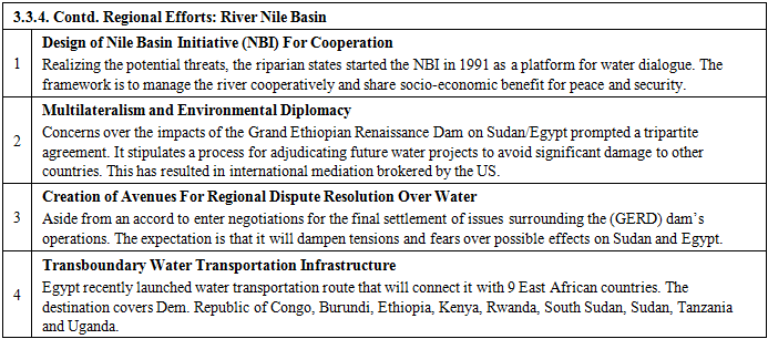
3.4.3. Regional Efforts
In the last several years, series of regional initiatives have been put into place by the nations in the Nile Basin to quell the recurrent water crises. Consistent with the ongoing initiatives are four principal themes germane to regional water access and security in the study area. This involves a) the design of Nile Basin Initiative (NBI) for Cooperation; b) the recourse to multilateral negotiations and environmental diplomacy; c) the creation of avenues for regional dispute resolution over water use; and d) the establishment of transboundary water transportation infrastructure linking the nations in the region. For more on the regional initiatives, see Appendix C.
4. Discussion
The enquiry focused on the assessment of transboundary water resource use with ample emphasis on the underlying trends, factors, impacts and efforts with revelations that identified common challenges of scarcity, water stress and the actual sectors using water, stock levels and consumption among the nations and major hydrological sources. The study also centered on the extent to which the shared water crisis in the River Nile Basin of Africa were rooted in a host of socio-economic forces of population and urbanization, institutional weaknesses together with physical and environmental factors. Of great importance in the enquiry is the disparity in water availability between the Sub-Saharan side of the region and the North African part. Even though the nations of Egypt and Sudan in North Africa appear to maintain a seemingly huge dominance in irrigation water use and the proportion of water consumption. They still emerged as the most vulnerable to hydrological stress particularly scarcity than some of their counterparts in East and Central Africa. All these notwithstanding, the region experiences periodic flashpoints of water insecurity and tensions among the nations due to the level of hydrological stress inherent in the area. In executing the task, the study applied mixscale model of descriptive statistics and geographic information systems (GIS) with data on various socio-economic and ecological indicators made up of population, rainfall, irrigation water and others.In the context of the study, transboundary water resource use based on hydropolitics tie up multiple nations sharing a river basin into a web of interdependencies even though they may have competing individual objectives on arriving at a common purpose of water access and security as shown in the River Nile Basin of the continent of Africa. Aside from the efforts to address the region’s transnational water issues through the Nile Basin Initiatives and mediations via environmental diplomacy in view of the threats of limited access and insecurity. The nations in the Nile Basin zone face also formidable tasks in mitigating water pollution threats and many limiting constraints. Accordingly, the Nile Basin nations of Egypt, Ethiopia and Sudan saw some major variability and stability in shared water indicators that are somewhat mixed and germane to the welfare of citizens. Interestingly, from 1990-2015,when Egypt, Burundi and Ethiopia, Uganda and others fared better in terms of access to potable water use, the same trio of nations in the zone Uganda, Ethiopia, and Egypt met their respective Millennium Development Goals (MDGs) agenda on water with some making progress as well. Yet, there is still disparity in access with Egypt’s consumption levels outpacing other nations regarding irrigation water usage. However, the Democratic Republic Congo and the other upstream nations have more fresh water and rainfall while North African states of Egypt and Sudan remain worse off when it comes to stress in that category of hydrological indicators. With Egypt and Ethiopia facing more unmet water demands in the zone, the results point to declines in several land cover indicators. This includes waterbodies, forests, and shrubs followed by the increases in cultivated land areas heavily reliant on the applications of chemicals. In the process, riparian systems like wetlands and water bodies vital for the hydrology and water security of the Nile Basin are not only degraded, but the situation seems compounded by the resultant environmental, economic and health impacts given the region’s fragile ecosystem. The GIS mapping of the patterns pinpointed a gradual dispersal of transboundary water sharing indicators and points in space with clusters of sources, the concentration of regional dichotomy over agreements in various scales throughout the basin coupled with a tapestry of infrastructure crucial for water security in the Nile River Basin over time.Just as the Nile basin nations still operate under a colonial era water sharing framework which originally, excluded the East African side in Sub Saharan Africa in favor of the Egypt/Sudan axis, transnboundary cooperation could be elusive if the signatories from North Africa do not respect the rights of independent East African states who have the same desires over shared waters in voiding the colonial treaty. Said that, let it be known that the anticipated population growth will create more problems in terms of access to quality water and jeopardize hydrological security. This will not only threaten the carrying capacity of an already fragile ecosystem, but it poses massive challenges for managers and policy makers in the region. Consequently, with the currency of the disputes and its insertion into the orbit of global community. The situation remains real with more attention than ever, given the geopolitical implications of the tensions ignited between the regional powers,Ethiopia and Egypt. Both nations are now engulfed in open dissentions regarding the proposed water diversions from the Blue Nile through Grand Ethiopian Renaissance Dam. Raising the stakes further over the issue is the involvement of the international community and world powers who share common interests in ongoing meetings towards a negotiated settlement over the impasse. Accordingly, there are several other interesting inferences worthy of mention from this study. To begin with, the intricacies of hydropolitics and the grid of interdependencies regularly linked with it among the various countries are evident in the Nile Basin region where parties involved juggle often with the challenges of access and water security in a changing environment under many factors located within the larger hydrological structure over the years. Considering the current diplomatic turnaround, the issues in shared waters in the Nile Basin are still negotiable under current circumstances seeing the array of global sensitivity to discords among the regional actors and the need for water security. For solutions to the water problems in the zone, the paper offered several recommendations ranging from support for collaborations to the need for the mapping of hydrological trends with spatial information systems. See Appendix D for details of the suggestions. Surely, the enquiry showed the proficiency of mix model in detecting the critical indicators essential in transboundary water management while pinpointing the common issues.
5. Conclusions
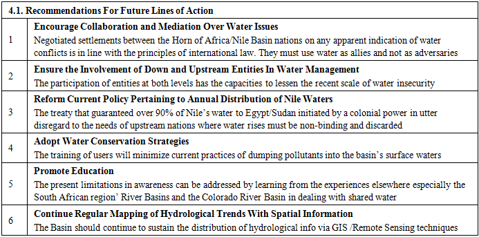
The study highlighted the prevailing water challenges in a transboundary setting amidst recurring stress with valuable closures captured in the ensuing headings: a) water stress on the rise; b) sharing formula lopsided; c) impacts evident; d) stress triggered by many factors; e) mix-scale approach quite feasible. 1). Water Stress On the Rise In the Nile Basin, part of the challenges associated with water security seem rooted to the degree in which communities in the region are exposed to scarcity especially in stressed areas of the zone amidst pressures from human activities. Seeing how the disparity in rainwater harvest limits access in some of the countries. In water stressed areas, shortfalls of the resource not only impede community access to quality sanitation, it undermines the capacity of farmers to cultivate and irrigate cash crops amidst limited distribution of hydro power. Thus, in those circumstances, the level of water insecurity in the Nile region seems more critical in the zone than other places in the African continent as 5.5 million hectares of land have been set aside for agriculture. From the continued uptick in animal husbandry operations, the strain on rangelands and the quest for hydrological resources has risen.Because of unsustainable land management programs in such settings, the intensity of stress on the ecology stifles availability of water assets as is the case among countries in the zone like Egypt where the drought levels have risen to extreme forms likely to dry out water reserves in the next 5 years. Thus, in the region, the mounting scarcity and degradation of hydrological assets do raise the stress levels threatening the wellbeing of citizens. In the process, several nations live on water quantities deemed below the officially designated levels per person. Accordingly, in 2010, along the Horn of Africa part of the Nile Basin, many nations experienced the most serious forms of drought that resulted in the death of over 200,000 individuals in which most of the deceased languished in communities deemed under water stress emergencies. In highlighting the surge in water stress and scarcity, the enquiry offers a template for the countries trapped in recurrent water anxiety in developing remedies for mitigating acute exposures to such problems in transboundary waters.2) Water Sharing Formula Lopsided and UnfairJudging from the findings of the enquiry pertaining to Nile Basin water issues. The most contentious thing in the region seems deeply rooted in the past, with ample divisiveness that permeated public discourse in the North and Southern parts of the zone. This fully involves the lopsided nature of the colonial era water allocation formula. Being a region where the largest beneficiaries of the transboundary water sharing treaty of the past century are the most water thirsty areas in the North. The arid nature of the environment in the Northern part of the Nile Basin accentuates the heavy dependence on water among the nations in that part of the study area. This occurs in the face of meagre possibilities in rainfall and the recurrent risks of lengthy drought therein. As a policy initiated by an outside imperial power during that sad era with the sole purpose of serving its own economic interests of agricultural productivity along the Nile Valley in order to secure a foothold into markets in the orient under the orbit of international capital. In authorizing the treaties of 1929 and 1959, the imperial order benefited Egypt and Sudan with vested guarantees of over 90% of the water in Nile Basin for the two North African nations. This occurred with ample disregard for the needs of the SSA nations and their sovereignty. Such deliberate misallocation of regional assets of others by a foreign power under the guise of colonial rule should not be used as an excuse to “rob Peter to pay Paul” at that material time or now, since it defies the spirit of Pan Africanism. Come to think of that, since Egypt and Sudan account for only 26.49% of the region’s population. There is seemingly no credible basis under international law that justifies the unilateral allotment of much of the common water rights in the basin to North Africa by an outside power. All it did was instil serious doubts in the minds of many given the lack of sincerity of purpose and equitable distribution. Since those SSA nations were no signatories to the agreements that traded away their water rights with no consultations. They are not legally bound to honor any past water treaties which could be interpreted as an infringement on their sovereignty unless they voluntarily waive their rights under a new deal that authorizes water transfer to their neighbors in the North. Considering that significant proportions of the water that accrues to Egypt comes via the Highlands in Ethiopia near the Blue Nile, the recourse to dialogue among these nations is the way out, so long as it serves permanent interests of the parties involved without imposing it on them. The acknowledgement of such uneven water treaty in the research under a draconian colonial premise that is at the root of the crisis while suing for dialogue among the nations in hydropolitics of the zone sets the enquiry apart in the search for a mutually agreeable treaty fair to all in the spirit of Pan Africanism free from the clutches of a neo-colonial agenda. 3) Impacts EvidentFrom the findings of the enquiry, the transboundary water issues in the Nile River Basin left in its wake numerous socio-economic, ecological and health impacts being felt in the countries of the zone. As a result, the frequency of severe drought devastations suffered by citizens in the area often translates into huge economic and social burdens with political consequences. With the anticipated costs in damages from droughts expected to dampen growth, the countries of the region are now braising for major declines in their respective national accounts by the mid-2020s due to the fallout from water scarcity. In lieu of these and the common obsession for development activities built on urbanization of cities and water intense agriculture involving unilateral diversions from common sources. The resultant spill overs from that and the imminent shortfalls in available water and stress in water security prompts forced migrations and the possibilities of conflicts in the region over access. Aside from the ecological effects of evaporation, sedimentation and cases of limited fish catches in adjacent rivers and water declines emanating from the design of dams across the region, the risks remain quite an unforgiving experience.Also, the shocking spike in malaria epidemics across the Horn of Africa side over the years, stems from the large number of dams and lakes designed to contain water shortage. The experience of the inhabitants of Koka reservoir, the largest mega dam in Ethiopia through exposures to plasmodium falciparum disease, is an indication of the extent to which the desire for water infrastructure intended to boost access in the region impacts the built environment and public health. Revealing these dangers in the face of the inherent stress, the water deficits, and the propensity to environmental health hazards herein, stands out as the pathway to water security and wellness of citizens and quality. 4) Water Crisis Triggered by Many FactorsAnother key finding touched on the underlying role of many factors most notably socio-economic (demography, growth and institutional) and environmental elements responsible for the water crisis in the Nile River Basin. Basically, the region’s teeming population growth rate which is among the highest in the world, cuts across the various countries, and it appears to have unleashed notable pressures to the hydrology. This not only accentuates water insecurity in a region that is already threatened by scarcity but meeting sectorial needs for communities stands as a recurrent challenge. Added to that, is the rapid pace of urbanization currently creeping into cities across the study area beginning from the East African side in the SSA to the North African countries of the Nile Basin classified at high and low double-digit rates. In all these, potable water usage among new households in burgeoning urban areas has grown as a result of rising demands in the face of fading state structures and the lack of modern amenities that are crucial in the provision of water to communities. At the same time, the study area and its adjoining localities exhibit a high propensity to extreme climate hazards like droughts precipitated by environmental change. In that way, changing climatic parameters continue to degrade the limited hydrological assets therein coupled with the spate of heavy floods in East Africa in 2006 to 2007 and those in the past decades. Also, the generation of large volumes of wastes threatens access to urban freshwater quality as contaminated rivers and lakes are stretched beyond their limits in the zone. In detecting these elements, this study ushered in a new focus for planners in assessing limiting forces to hydrological access in transboundary water use.5) Mixscale Model FeasibleIn highlighting the issues of transboundary water resource use among nations in the Nile Basin area of Africa between 1990 and 2019, mix-scale model injected novel scenarios involving hydrological indicators not seen previously by planners in the political hot bed. Accordingly, the applications of descriptive statistics in that mode showcased sparkles of innovation in the capability of the technique to identify the extent of consumption within the individual nations in the zone with potentials and liabilities in terms of availability, surpluses, access and scarcities amidst the exposures to hydrological stress. From the scales at which GIS mappings pinpointed the spatial patterns of modern-day water agreements and the cooperative framework on sharing and the disagreements among the nations. The tool was quite effective in delineating in space, clusters of transboundary water sources and infrastructure symbolizing network of dams. The implications based on the evolving forms in water resource use in the region enhances the capacity required in the efficient distribution of shared water by managers. Correspondingly, the broad GIS visualization added effective touch in mapping the concentration of per capita wealth among the nations and their irrigation activities and projected levels and other hydrological indicators spread across the zone. Building on the makeup of that method, and array of indices as presented, planners will be better equipped in crafting the right approaches that recognize regional distribution based on cooperation and the design of amenities cognizant of water resource issues and the hydrological mine fields likely to avoid. Given the availability of the model, researchers and managers and regional stake holders and users, now have info on temporal-spatial dimensions of hydrological assets in a contentious transboundary setting that is vulnerable to water insecurity and tensions.Considering the mounting challenges and consumption levels and the distribution formats associated with transboundary water resources over the years, together with the recurrent flash points of water stress, regional disputes and sectoral allocations and the pursuit of hydrological infrastructure as manifested in this enquiry. Planners and researchers will all be hard pressed to elicit immediate answers to several queries that are pertinent to hydrological security in turbulent environments. The queries are as follows: How will future use influence water access in the Nile Basin? How will environmental change affect transboundary water flow across the region? What is the relationship between sectoral demands and the water policy in the Nile Basin? What are the essential ingredients for ending transboundary water crisis in the study area? What are the needed steps towards the attainment of water security in the zone? Based on these queries, ample possibilities exist for more studies and planning intervention to refocus the policy priorities on transboundary water access.
Appendix A
Appendix B
Table 10. Land Cover Changes Horn of Africa
 |
| |
|
Appendix C
Appendix D
References
| [1] | Delli Priscoli, (1998). Water and civilization: Conflict, cooperation and the Roots of a New Eco-Realism. Stockholm, Sweden. 17 pp. |
| [2] | Biswas, Asit, K. (1996). Water Resources Management: Environmental Planning, Management, and Development. McGraw-Hill. p.18. |
| [3] | USAID. (December 2011). Water Security in The Horn of Africa. From https://blog.usaid.gov/2011/12/water-security-in-the-horn-of-africa/ on June 20 2018. |
| [4] | Abdullahi Elmi Mohamed (2002). Need For Transboundary River Cooperation; The Case of the Juba & Shabelle River Basins in the Horn of Africa. In Proceedings of the Horn of African Country Rivers Conference, Lund Sweden 10 - 12 May 2002. |
| [5] | World Water Council (2011). Marseille, France. Water For Growth and Development In Africa A Framework For An Effective Mosaic Of Investments. http://www.worldwatercouncil.org/fileadmin/wwc/Library/Publications_and_reports/Africa_Report.pdf. |
| [6] | USAID (2014). Water and Conflict. A Toolkit For Programming. Taken From https://www.usaid.gov/sites/default/files/documents/1866/WaterConflictToolkit.pdf. On June 2018. |
| [7] | Abdullahi,. Elmi (2010). Hydropolitics in the Horn of Africa – Conflict and Required Cooperation in The Jubba andShabelle Rivers. In: Shared waters, shared opportunities: Hydropolitics inEast Africa (eds.) Bernard Calas and C. A. Mumma Martinon. Nairobi, Kenya. p. 37–52. |
| [8] | Fatovich, Laura (2017 June). Drying Up: Kenya-Ethiopia Cross-Border Agreements Will Not Fix Water Crisis. Indian Ocean Research Program. |
| [9] | Elhance, Arun, (1999). Hydropolitics in the Third World: Conflict and Cooperation in International River Basin’. United States Institute of Peace, Washington, D.C. p. 13, 233. |
| [10] | World Bank, (1998). International Watercourses: Enhancing Cooperation and Managing Conflict. Salman M. A. Salman and Laurence Boisson deChazournes. |
| [11] | Abdullahi, Elmi, (2013). Managing Shared River Basins In the Horn of Africa: Ethiopian Planned Water Projects On The Juba and Shabelle Rivers and effects on Downstream Uses In Somalia. WIT Transactions on Ecology and The Environment, 172: 139-151. |
| [12] | Chandler, David L. (2015 April). International Experts Analyze Impacts of Ethiopian Dam. Report From Conference At MIT Addresses Potential Effects of Huge Construction Project. Boston, MA. MIT News Office. |
| [13] | Korwa G. (2007). The Riparian States of the Nile River, Their National Interests and Regional Stability. African sociological Review. 11: 1. |
| [14] | United Nations Population Division (2010). Water Resources Atlas for the Nile Basin. USAID, ESA Glob Cover. |
| [15] | Tierney, Jessica. (2015 October). Past and Future RainFall In The Horn of Africa. Science Advances. 1:9. |
| [16] | Noah, Arre. (2006). Infrastructure and Water Development. Horn of Africa Peace and Development Center. Taken On 20 June 2018. From http://hafrica.org/docs/Infrastructure%20and%20Water%20Development%20paper.pdf. |
| [17] | Mao, Hassan. (2013 October). Water insecurity in the Horn of Africa: scarcity or institutional failure? Hiiraan Taken on June 20 2018 From https://soso.bz/ZPo23vKKe. |
| [18] | Amin, Noah (2007). Water Scarcity In The Horn Of Africa And Its Deadly Consequences. |
| [19] | Marcel Rutten. (2017). Water in Africa. African Studies Center Liden. library of the African Studies Centre. Leiden The Netherlands. |
| [20] | African Yearbook of International Law: (2008). Water resources in the Sudan North-South Peace Process: Past Experience and Future Trends .African Yearbook of International Law. 16. 299-328. |
| [21] | Shore, Rebecca. (2019). Water In Crisis – Ethiopia. Concord, NH. The Water Project international water charity. https://thewaterproject.org/water-crisis/water-in-crisis-ethiopia. |
| [22] | Sebhat, Mesenbet Y. (2014 June). Water Balance of the Juba and Shabelle River Basins the Horn of Africa. International Journal of Agricultural Policy and Research. 2 (6), 238-255, 2014 Available online at http://www.journalissues.org/ijapr/. |
| [23] | Van de Giessen, Eric. (2011 January). Horn of Africa Environmental Security Assessment. The Hague, The Netherlands, Institute for Environmental Security. 7-141 pp. |
| [24] | Merem, E. C. and Twumasi, Y. A. (2019, March). Analyzing Current Transboundary Water Issues and Hydro Politics of the Horn of Africa Region”. 93rd Annual Meeting of the Louisiana Academy of Sciences, Baton Rouge, LA. |
| [25] | Okoth-Owiro, Arthur (2004). The Nile Treaty: State succession and International Treaty Commitments: A Case Study of The Nile Water Treaties/. Nairobi: Kenya, Konrad Adenauer Foundation, (Occasional papers. East Africa, ISSN 1681-5890; 9. |
| [26] | KagwanjaIn, Peter. (2007). Calming the Waters: The East African Community and Conflict Over The Nile Resources. Journal of Eastern African Studies. 1: 3: 321-337. |
| [27] | Korybko, Andrew (2017 April). Africa, China and Egypt: New Rumblings Horn of Africa: Over Ethiopia’s Grand Renaissance Dam. Oriental Review. https://orientalreview.org/2017/12/04/new-rumblings-horn-africa-ethiopias-grand-renaissance-dam/. |
| [28] | Murali, Pai (2014). Water Issues In the Horn of Africa. African Conservation Telegraph Ethiopia, Somalia, Eritrea, and Djibouti. |
| [29] | Adam, Allington. (2018 January). Is a Water War About to Break Out Along the Nile? Environment and Energy Report. Bloomberg. |
| [30] | Manu, Sarpong Kwabena. (2009). Africa Regional Paper: Bridging Divides In Africa's Water Security, An Agenda To Implement Existing Political Commitments. African Development Bank, Abidjan. |
| [31] | Dahilon Yassin Mohamoda (2003). Nile Basin Cooperation: A Review of The Literature. - Uppsala: Nordiska Afrikainstitutet. |
| [32] | The Heinrich Böll Foundation. (2008 September). East Africa / Horn of Africa – Environment, Nairobi Keyna, Heinrich Böll Foundation. |
| [33] | Walsh, Benjamin (2017 April) Crisis In the Horn of Africa: Are We Seeing The Normalisation of Food and Water Insecurity. Dalkeith WA, Australia. Future Directions International. |
| [34] | Makpenon, Michel (2011 Jun) Home, Land and Environment: The Water Crisis In African Cities. NBP http://www.pambazuka.org/images/articles/533/cotonou_access_to_water.jpg. |
| [35] | Mazur, Laurie. (2012ebruary). Water and Population: Limits to Growth. DC: Washington. Environmental Change and Security Program. Woodrow Wilson International Center for Scholars. https://www.newsecuritybeat.org/2012/02/water-and-population-limits-to-growth/. |
| [36] | Knudsen, Devon (2014). Water Security No Longer a “Future Threat” for Sahelian. African Arguments, Royal African society. |
| [37] | Carlson, Andrew. (2013 march). Who Owns the Nile? Egypt, Sudan, and Ethiopia’s History-Changing Dam. Origins: Current Events in Historical Perspective. 38: 6:6. |
| [38] | The Africa Report. (2013 October). Water Solutions: Power For Ethiopia, Water for Egypt. |
| [39] | United Nations. (2005). Hydropolitical Vulnerability and Resilience Along International Waters. Nairobi: Kenya: United Nations Environment Programme, Africa/. |
| [40] | Merem, E. C. and Twumasi, Y. A. (2006). Hydropolitics: Case of the Niger River Basin. GIS Development: Africa, 24-28. |
| [41] | Loots, Lliane. (2011). The Politics of Water. Durban: Agenda; Feminist Media. 88. |
| [42] | Turton, Anthony (2002). Hydropolitics In The Developing World: A Southern African Perspective. Pretoria: African Water Issues Research Unit, Centre for International Political Studies, University of Pretoria. |
| [43] | Seleshi Bekele Awulachew (2007).Water resources and irrigation development in Ethiopia.Colombo: International Water Management Institute. (IWMI working paper 123. |
| [44] | Collins, Robert O. (2002). The Nile - New Haven: Yale University Press. |
| [45] | Waterbury, John. (2002). The Nile Basin: National Determinants of Collective Action. New Haven, CT: Yale University Press, 2002. |
| [46] | Sampson, Ian. (2011 April). Transboundary Water Disputes In Africa. South Africa Environmental and Clean Energy Law Department. |
| [47] | IPCC (2007) Climate Change: Synthesis Report, IPCC. |
| [48] | Michel, David. (2013 June). Opinion: Egypt, Ethiopia Water Dispute Threatens Nations. International Business Times. http://www.ibtimes.com/egypt-ethiopia-water-dispute-threatens-nations-1324189. |
| [49] | Abdullahi, Elmi. (2014) Comparing Africa’s Shared River Basins-The Limpopo, Orange, Juba and Shabelle Basins. Universal Journal of Geoscience. 2:7: 200-211. |
| [50] | Merem, E. C. (2006). GIS and Remote Sensing Applications in the Hydropolitics of Sub-Saharan Africa: The Case of Multinational Management of the River Niger Water Basin. Paper Presented At the National Water Monitoring Conference, San Jose, CA. |
| [51] | Erlich, Haggai. (2002). The Cross and The River: Ethiopia, Egypt, and the Nile. Boulder and London: Lynn Rienner Publishers. |
| [52] | United Nations. (2013). Water Security: Experts Propose a UN Definition on Which Much Depends. https://unu.edu/media-relations/releases/water-security-a-proposed-un-definition.html#info. |
| [53] | Goldenberg, Suzanne. (2018 February). Global Water Shortages To Deliver Severe Hit To Economies, World Bank Warns. The Guardian. |

 Abstract
 Reference
 Full-Text PDF
 Full-text HTML