-
Paper Information
- Next Paper
- Paper Submission
-
Journal Information
- About This Journal
- Editorial Board
- Current Issue
- Archive
- Author Guidelines
- Contact Us
World Environment
p-ISSN: 2163-1573 e-ISSN: 2163-1581
2019; 9(2): 29-37
doi:10.5923/j.env.20190902.01

Geotechnical Evaluation of Gravels Quarries Exposed Along Eastern Nile Valley Bank, Qena Region, Egypt
 Abstract
 Reference
 Full-Text PDF
 Full-text HTML
Hesham A. H. Ismaiel
Department of Geology, Faculty of Science, South Valley University, Qena, Egypt
Correspondence to: Hesham A. H. Ismaiel, Department of Geology, Faculty of Science, South Valley University, Qena, Egypt.
| Email: |  |
Copyright © 2019 The Author(s). Published by Scientific & Academic Publishing.
This work is licensed under the Creative Commons Attribution International License (CC BY).
http://creativecommons.org/licenses/by/4.0/

Geotechnical behavior of Quaternary gravels exposed along the eastern Nile valley bank at Qena region was investigated to evaluate their proportion for using as quarries. To achieve this aim, thirty six specimens of the studied Quaternary gravels were collected from different six sites represented six gravels quarries distributed along the eastern Nile valley bank at Qena region. Chemical and mineralogical analyses of the studied gravels were carried out. A percent of soluble sulfates and chlorides of the studied gravels were measured. Physical and geotechnical parameters including specific gravity, water absorption, degradation in water, particle size analysis, adhering clay lumps percent, elongate/flatness percent, Les Angeles percent, California bearing ratio, potential alkaline reactivity as well as proportion of the loss of the studied gravel were tested. The results showed that the studied gravels distributed at the studied area were belonging to Quaternary alluvial fans and stream sediments and the main source rocks were Upper Cretaceous/Lower Tertiary succession and basement complexes (Red Sea Mountains). The results showed also that the studied gravels were convenient for quarrying. They could be applied in road constructions, asphalt mixtures, and cement concretes except the gravels at Qena-Safaga quarry which were not fit for using in cement concretes. That due to the studied gravels at Qena–Safaga quarry contained a high percent of soluble chlorides. The proportion of the loss of the investigated gravels at the studied quarries was ranging from 41.50 to 48.27%. All the studied gravels quarries passed in the potential alkaline reactivity test.
Keywords: The proportion of the loss of the gravels deposits, Potential alkaline reactivity, Quaternary gravels, Les Angeles percent, Water absorption and degradation, Dissolved sulfates and chlorides
Cite this paper: Hesham A. H. Ismaiel, Geotechnical Evaluation of Gravels Quarries Exposed Along Eastern Nile Valley Bank, Qena Region, Egypt, World Environment, Vol. 9 No. 2, 2019, pp. 29-37. doi: 10.5923/j.env.20190902.01.
Article Outline
1. Introduction
- In Egypt, especially in the eastern desert, there is a huge amount of natural aggregates which consider an economic deposit. They can be used in different engineering applications such as road constructions, cement concretes, and asphalts mixtures. These natural aggregates need to evaluate their geotechnical behavior to determine their fitting for quarrying and for using in different engineering applications [1]. The gravels quarries exposed along the Eastern Nile valley bank are representing very important sources of construction materials at Qena region which help in the urban extension and construction of the new cities like new Qena city. The geotechnical behavior and the potential alkaline reactivity as well as the proportion of the loss of the gravels deposits are very important factors to assess the quality and the economic importance of the gravels deposits.
1.1. Previous Works
- The investigated area was geologically studied by several authors. Some sedimentlogical and mineralogical studies were carried out by [2-17]. Structural and tectonics investigations were conducted by [18-24]. Geological hazards investigation was carried out by [25]. Few geotechnical studies were done by [26-34].
1.2. Location of the Study Area
- The study area locates in the eastern Nile valley bank at Qena region. It extends along the eastern Nile valley bank from Qus (South) to Dishna (North). It lies between latitudes 25° 47¯ and 26° 17¯ N and longitudes 32° 26¯ and 32° 53¯E. Six quarry faces at different locations are selected along the eastern Nile valley bank to evaluate the studied Quaternary gravels (Table 1 and Figure 1 & 2).
|
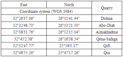
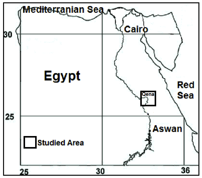 | Figure 1. Location map of the studied area |
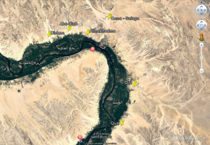 | Figure 2. Satellite image illustrates the distribution of the studied gravels quarries |
1.3. Scopes of the Present Work
- The present work dealt with an investigation of the geotechnical behavior of the Quaternary gravels exposed along the studied area to evaluate their proportion for using as gravels quarries. The main scope of this study was an evaluation of the studied gravels for using in different engineering applications especially road constructions, cement concretes, and asphalt mixtures.
1.4. Geological Setting
- The Nile valley is bounded by two extensive plateaus at the study Qena region. These plateaus are composed of Upper Cretaceous-Lower Tertiary rocks. They are drained by a great number of structural controlled Wadis. The studied Quaternary sediments, at Qena region, are bounded by the Upper Cretaceous-Lower Tertiary successions from the east and west in addition to the basement complexes in the east [30]. The studied quarries include a variety of sediments which differ in mineral composition and texture reflecting the environmental sedimentary nature of the Quaternary sediments. The distribution of the studied sediments is mapped in some details in a geological map (Figure 3). The quaternary sediments, at the study area, include the Prenile sediments (Qena sands and Kom Ombo gravels) and Bank sediments (Nile silt). Prenile sediments represent a thick and easily recognizable unit made up mainly of sands which seem to have been deposited by a competent river having E-W trend [18]. These sediments are divided into two units namely Qena sands at the base and Kom Ombo gravels at the top [11]. The quaternary gravels at the study quarries are belonging to Prenile Kom Ombo gravels.
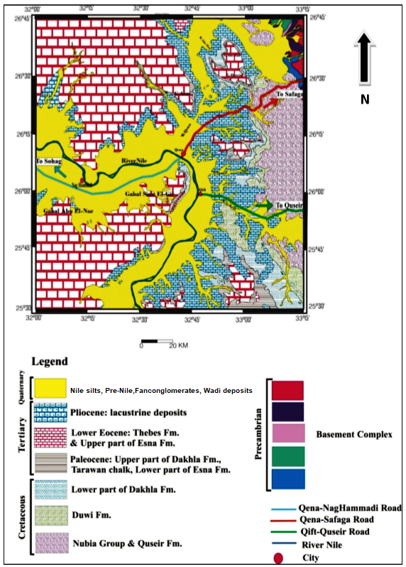 | Figure 3. Geological map of the studied area modified after [30] |
2. Materials and Methods
2.1. Materials
- Thirty six specimens of the studied gravels were collected from six quarry faces distributed along the Eastern Nile valley bank at Qena region. The weight of each sample was equal to 30.00 kg. The studied gravels are Fan-conglomerates and Wadi deposits and belong to Quaternary age (Pleistocene). The length of the studied quarry faces is 100 m except Qift quarry face is 200 m long. The thickness of the quarry faces are ranging from 3 to 6 m (Figure 4 & 5). The fine materials relatively increased at the surface of all the studied quarries gravels deposits. Qus quarry gravels deposits are covered with thin layer of fills (fine grained soils) ranging in thickness from 0.30 to 1.00 m. The petrographical examination of several representative gravel grains of the studied samples under the polarized light microscope showed that the studied gravel grains of Qena-Safaga, Almakhadma, Abo-Diab, and Dishna quarries were mainly composed of very hard crystalline limestone, hard marly limestone and partially recrystallized chalky limestone. Some gravels grains were composed of very hard partially silicified limestone. Some examined grains were very hard flint and composed of quartz. The studied gravels grains collected from Qift and Qus quarries were mainly composed of limestones and basement rocks like granites, gabbros, diorites, basalts, and rhyolites.
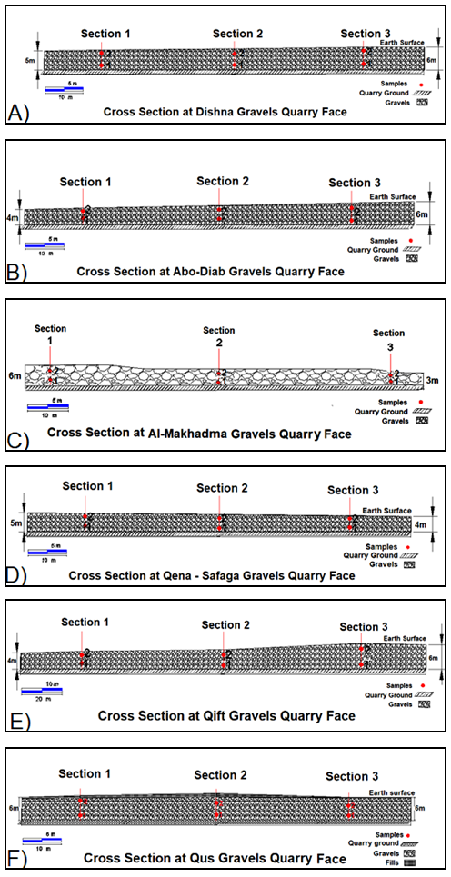 | Figure 4. Six cross sections at the studied gravels quarries faces |
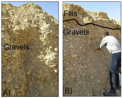 | Figure 5. Photos of the studied gravels quarry faces at A) Qena-Safaga and B) Qus |
2.2. Methods
- Chemical and mineralogical analysis (X-ray fluorescence, XRF and X-ray diffraction, XRD) of the studied gravels were conducted. Dissolved sulfates [35] and chlorides [36] were measured. Physical parameters including specific gravity, water absorption and degradation [37], particle size analysis [38], adhering clay lumps percent [39], and elongate/flatness percent [40] were tested. Geotechnical parameters like Les Angeles percent [41] and California bearing ratio [42] were measured. Additional tests were carried out including proportion of loss [43] and potential alkaline reactivity [44] of the studied Quaternary gravels (Figure 6).
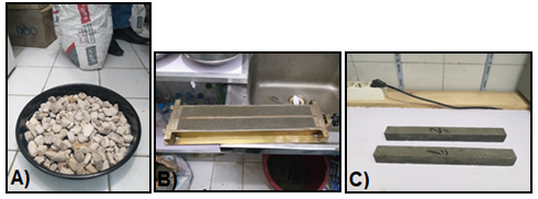 | Figure 6. A) Dishna gravels samples, B) Two prism molds, and C) Two prepared prism samples for testing |
3. Results
3.1. Chemical and Mineralogical Results
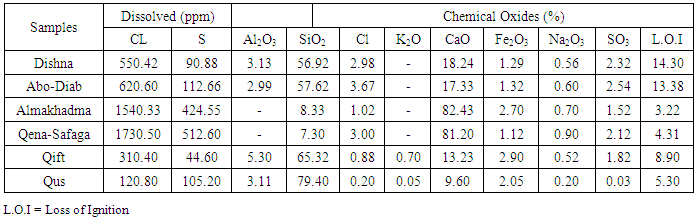
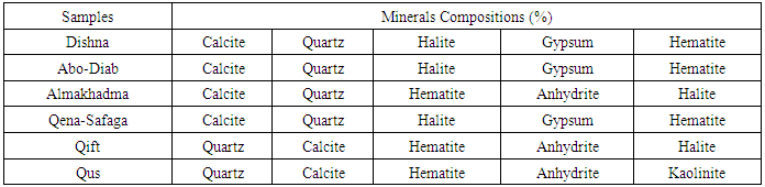
- The chemical analysis results illustrated that the studied Dishna and Abo-Diab gravels were mainly composed of silica (56.92 to 57.62%), calcium (17.33 to 18.24%), and aluminum (2.99 to 3.13%). The studied Almakhadma and Qena-Safaga gravels were mainly composed of calcium (81.20 to 82.43%), silica (7.30 to 8.33%), and iron (1.12 to 2.70%). The studied Qift and Qus gravels were mainly composed of silica (65.32 to 79.40%), calcium (9.60 to 13.23%), and aluminum (3.11 to 5.30%). The sample of Dishna, Abo-Diab, and Qena-Safaga gravels were contained higher chlorides (2.98 to 3.67%) and sulfates (2.12 to 2.54%). The results showed also that the soluble salts including sulfates and chlorides of the studied samples were ranging from 44.60 to 512.60 ppm and from 120.80 to 1730.50 ppm respectively. The soluble sulfates and chlorides of the sample at Almakhadma and Qena-Safaga were the highest. The mineralogical analysis results illustrated that the studied gravels were mainly composed of calcite, quartz, halite, gypsum, and hematite (Table 2 & 3).
|
|
3.2. Physical and Geotechnical Results
3.2.1. Specific Gravity, Water Absorption, and Degradation in Water
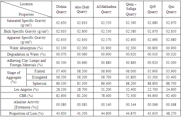
- The results showed that the specific gravity values of the studied gravels samples were ranging from 2.57 to 2.69 g/cm3. The water absorption values of the tested samples were ranging from 0.80 to 2.30%. The results illustrated also that the degradation in water values of the investigated gravels were ranging from 0.01 to 0.92% (Table 4).
|
3.2.2. Adhering Clay Lumps and Foreign Materials
- Table 4 illustrated the percent of the adhering clay lumps and the friable particles of the testes gravels. The values were ranging from 0.50 to 1.00.%
3.2.3. Sieve Grain Size Analysis
- The results pointed to that the studied samples were composed of gravel size (75 to 82%) and sand size (18 to 25%), as shown in Figure 7. The studied samples were classified according to unified soil classification system (USCS) as GP, poorly graded gravel, and as A1-a to A1-b, group one, according to American association of state highway and transportation official (AASHTO).
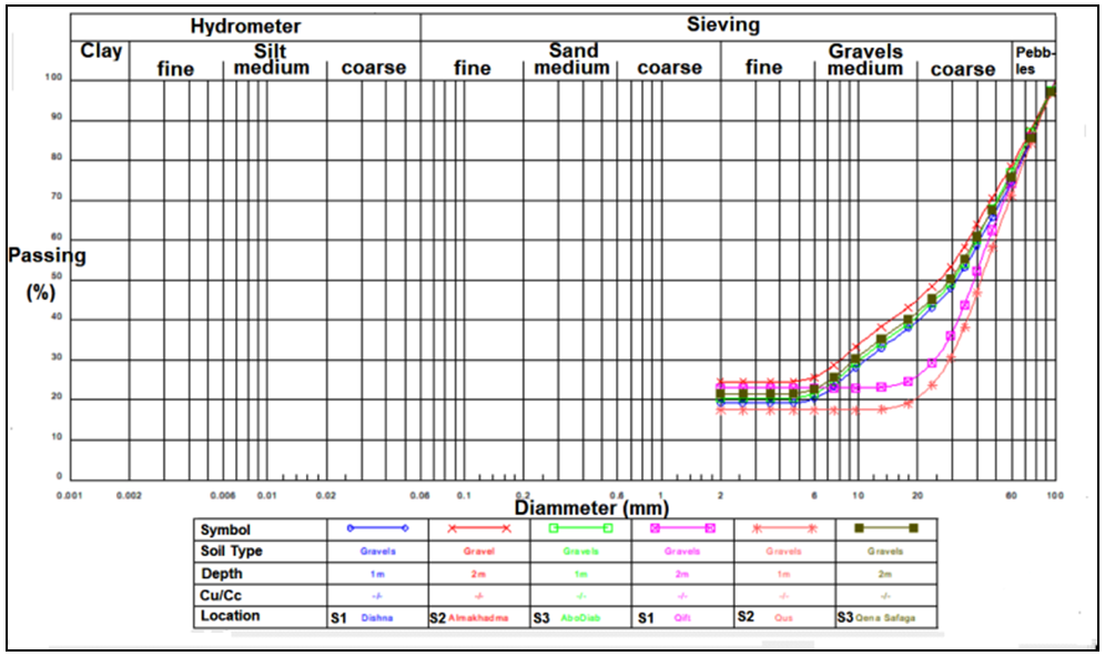 | Figure 7. Grain size distribution curves of the studies gravels samples |
3.2.4. Shape of Aggregates
- Table 4 illustrated the percent of the different grain shapes of the studied gravels samples including spherical, elongated, and flatted shapes. The percent of the spherical shape was ranging from 85.30 to 88.80%. The percent of elongated shape was ranging from 5.30 to 6.70%. The flatted shape percent of the tested samples was ranging from 5.90 to 8.50%.
3.2.5. Les Angeles Percent and California Bearing Ratio
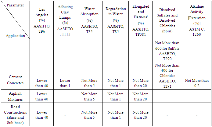
- Table 4 showed the les Angeles percent and the California bearing ratio values of the investigated gravels. The percent of Les Angeles of the tested samples was ranging from 22.70 to 32.40%. The result illustrated that the California bearing ratio of the studied gravels samples was ranging from 72.30 to 94.60%. Table 5 showed specification limits of the gravels used in different engineering applications according to AASHTO and ASTM (Figures 8 and 9).
|
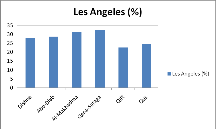 | Figure 8. Les Angeles values of the studied quarry gravels |
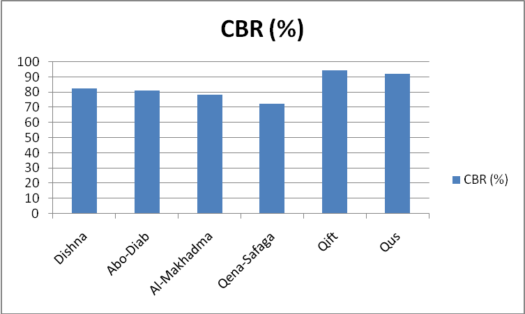 | Figure 9. CBR values of the studied quarry gravels |
3.3. Proportion of the Loss of the Gravels
- According to the Egyptian standard specification (ESS), the proportion of the loss of the gravels is equal to the percent of the grains size having more than 63 mm plus the percent of the grain size having less than 4.75 mm. Based on ESS, the gravels having grain size between 19 to 37.5 mm used in concrete mixtures and between 50 to 63 mm used in asphalt mixtures. After examination of the studied quarry faces and the grain size analysis, the results pointed to that the proportion of the loss of the gravels deposits at the studied quarries was ranging from 41.50 to 48.27% (Figure 10).
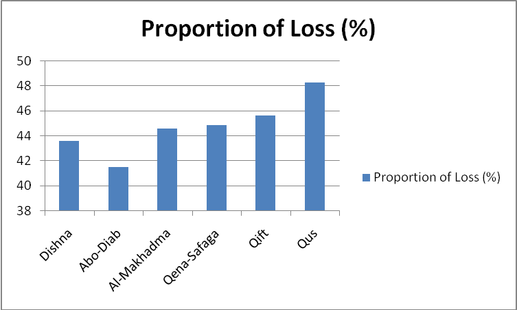 | Figure 10. Proportion of Loss values of the studied quarry gravels |
3.4. Potential Alkali Reactivity
- This test method provides a means of detecting the potential of an aggregate intended for use in concrete for undergoing alkali – silica reaction resulting in potentially deleterious internal expansion [44]. The results illustrated that the expansion values of the studied gravels at the study area were ranging from 0.066 to 0.144% (Figure 11).
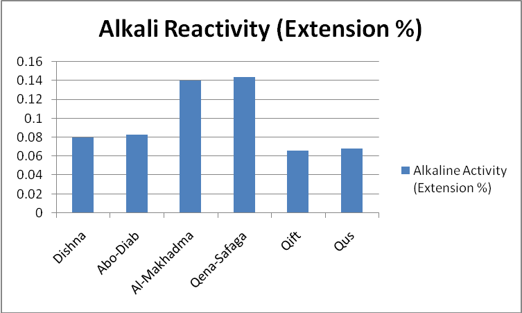 | Figure 11. Alkali Reactivity, Extension values of the studied quarry gravels |
4. Discussions, Conclusions, and Recommendations
4.1. Discussions and Conclusions
- The chemical analysis results pointed to that the studied Dishna and Abo-Diab gravels were mainly composed of silica (56.92 to 57.62%), calcium (17.33 to 18.24%), and aluminum (2.99 to 3.13%). The tested Almakhadma and Qena-Safaga gravels were mainly composed of calcium (81.20 to 82.43%), silica (7.30 to 8.33%), and iron (1.12 to 2.70%). The investigated Qift and Qus gravels were mainly composed of silica (65.32 to 79.40%), calcium (9.60 to 13.23%), and aluminum (3.11 to 5.30%). The gravels samples of Dishna, Abo-Diab, and Qena-Safaga gravels were contained higher chlorides (2.98 to 3.67%) and sulfate (2.12 to 2.54%). The results illustrated also that the soluble salts including sulfates and chlorides of the studied samples were ranging from 44.60 to 512.60 ppm and from 120.80 to 1730.50 ppm respectively. The soluble chlorides of the gravels samples at Dishna, Abo-Diab, Almakhadma, and Qena-Safaga were the highest. Accordingly, the gravels at these quarries were not suitable for using in cement concretes [35] and [36]. The mineralogical analysis results illustrated that the tested gravels were mainly composed of calcite, quartz, halite, gypsum, and hematite. The specific gravity values of the studied gravels samples were ranging from 2.57 to 2.69 g/cm3. The specific gravity of the gravels is considered to be a strong indicator of the strength or the quality of the gravel type [37]. The results pointed to that the studied gravels were dense and hard. The water absorption values were ranging from 0.80 to 2.30% (Not more than 5%). The degradation in water values were ranging from 0.01 to 0.92% (Not more than 1%). These values pointed to that the studied gravels were suitable for cement concretes, asphalt mixtures, and road constructions (as base and sub-base) based on [37]. One of the main factors for cement concrete to achieve a good strength is the bond between gravel and both sand and cement. This bond is greatly affected by the presence of dust on the aggregates particles or any other materials adhering to them such as clay and friable particles [39]. The percent of the adhering lumps and the foreign materials of the investigated gravels samples were ranging from 0.50 to 1.00%. These foreign materials should be less than 1% by weight based on [39]. That meant the foreign materials of the studied gravels were suitable for the cement concretes. The tested gravels samples at the study area were contained about 75 to 82% gravel size and about 18 to 25 % sand size. They were classified based on unified soil classification system (USCS) as GP, poorly graded gravel, and as A1-a to A1-b, group one, based on American association of state highway and transportation official (AAHSTO). The recommended sizes of the gravels are 38.1 - 4.75 mm, 19.5 - 4.75 mm, and 12.6 - 4.75 mm [38]. The grain size of the investigated gravels at the six studied quarries had the standard grain size range. The gravel grains should be generally spherical or cubic in shape. The percentage of flatted and elongated grains in any size group should not exceed 20% [38]. The percent of the spherical shape of the studied gravels was ranging from 85.30 to 88.80%. The percent of the elongated shape was ranging from 5.30 to 6.70%. The flatted shape percent was ranging from 5.90 to 8.50%. The elongate and flatness of the tested gravels at the investigated area were suitable for quarrying and for using in the road constructions, the cement concretes, and the asphalt mixtures [40]. The percent of Les Angeles of the studied gravels was ranging from 22.70 to 32.40%. The les Angeles percent should not exceed 50 % for the base and sub-base aggregates in road construction and not exceed 40% for the aggregates of cement concretes and asphalt mixtures. That meant the tested gravels were suitable for the road construction as base and sub-base and for the cement concretes and the asphalt mixtures [41]. The California bearing ratio of the studied gravels was ranging from 72.30 to 94.60%. The lowest values of the studied gravels samples were at Qena-Safaga, Almakhadma, Abo-Diab, and Dishna, that may be due to these gravels composed mainly of carbonates rocks. The highest values were at Qift and Qus quarries that may be due to these gravels composed mainly of mixture of basement and carbonates rocks. The typical CBR-values of the studied graded gravels are ranging from 60 to 80% based on [42]. All the studied gravels had CBR-values more than 50%. The studied gravels occurred along the investigated area were suitable for the road constructions where they were hard enough to withstand abrasion from tires, strong enough to support the load of vehicles, and sound enough to withstand wetting and drying conditions. The chemical and mineralogical composition of the studied gravels as well as the petrographical examination indicated that they were belonging to Quaternary alluvial fans and stream sediments, the main source rocks of the Qena-Safaga, Almakhadma, Abo-Diab, and Dishna quarries might be the Serai limestone plateau (Lower Eocene) which composed of different carbonate facieses (crystalline, partially recrystallized chalky limestone, and partially silicified limestone) and flints at the base. The main source rocks of the Qift and Qus quarries might be the Serai limestone plateau (Lower Eocene) and basement rocks including granites, gabbros, diorites, basalts, and rhyolites. The proportion of the loss of the gravels deposits at the studied quarries was ranging from 41.50 to 48.27%. Qus gravels quarry had the highest loss value that due to occurrence of fills layer covered the gravel deposits ranging in thickness between 0.30 to 1.00 m. All the tested gravels quarries passed in the potential alkali reactivity test, where the extension percent of all the studied prisms, after 14 days submersion in a sodium hydroxide solution, was ranging from 0.066 to 0.144 and less than 0.2% according to [44], that meant all the tested gravels prisms at the study area passed in the potential alkali reactivity test. Finally, the gravels deposits at the eastern Nile valley bank at Qena region are in a huge amount and have a good quality and can be used in different engineering applications.
4.2. Recommendations
- Geotechnical evaluation of the gravels quarries at the western Nile bank at Qena region is recommended. Comparison between the gravel quarries at both eastern and western Nile bank is suggested.
ACKNOWLEDGEMENTS
- Greatly thanks to staff members of quarries administration, Qena governorate for valuable cooperation. Special thanks for the geologist: Hosam Hasan for valuable help.