-
Paper Information
- Paper Submission
-
Journal Information
- About This Journal
- Editorial Board
- Current Issue
- Archive
- Author Guidelines
- Contact Us
World Environment
p-ISSN: 2163-1573 e-ISSN: 2163-1581
2018; 8(3): 63-70
doi:10.5923/j.env.20180803.01

Geotechnical Investigations and Assessment of Earthquakes Factors at Hurghada City, Red Sea, Egypt
 Abstract
 Reference
 Full-Text PDF
 Full-text HTML
Hesham A. H. Ismaiel
Department of Geology, Faculty of Science, South Valley University, Qena, Egypt
Correspondence to: Hesham A. H. Ismaiel, Department of Geology, Faculty of Science, South Valley University, Qena, Egypt.
| Email: |  |
Copyright © 2018 The Author(s). Published by Scientific & Academic Publishing.
This work is licensed under the Creative Commons Attribution International License (CC BY).
http://creativecommons.org/licenses/by/4.0/

There is a lack of the geotechnical investigations, at the study area, which contribute to deep understand the site effect which may be lead to amplification of earthquake ground motion especially in the presence of problematic soils and to estimate the earthquake factors. The present work is a contribution to bind the geotechnical investigations and earthquakes studies together at the study area. The present study focuses on the assessment of geotechnical parameters and earthquakes factors of a large occasion's halls project constructing at Hurghada city, Red Sea, Egypt. The geotechnical parameters are including gradation parameters, shear velocity (Vs), shear parameters (frictional angle and cohesion), young modulus (Es), and allowable bearing capacity. The earthquakes factors including soil coefficient (S), limits of constant value for elastic response spectrum (TB and TC), and specified value for begin of the constant displacement spectrum (TD) as well as assessment of design ground acceleration (ag). To fulfillment these objectives, six mechanical wash boreholes were conducted. Sixty disturbed samples were collected. Several geotechnical tests like grain size analyses, shear velocity (Vs), tri-axial shear, and standard penetration tests (SPT) were carried out. The results illustrated that the ag-value of the investigated area was 0.25 g. Depending on Egyptian code for vibration and dynamic load foundations, the investigated project area was classified as high potential seismic (zone no. 5A). The earthquakes factors including S, TB, TC, and TD were 1.80, 0.10, 0.30, and 1.20 respectively. Based on Egyptian code for shallow foundation, the allowable bearing capacity of the investigated soils was ranging from 1.5 to 2.5 kg/cm2. Structural mat shallow foundations with increasing the weight and the thickness of the reinforced concrete or deep pile foundations were recommended.
Keywords: Seismic Hazard, Earthquakes Factors, High potential seismic zone
Cite this paper: Hesham A. H. Ismaiel, Geotechnical Investigations and Assessment of Earthquakes Factors at Hurghada City, Red Sea, Egypt, World Environment, Vol. 8 No. 3, 2018, pp. 63-70. doi: 10.5923/j.env.20180803.01.
Article Outline
1. Introduction
- Hurghada city is located along the coast of Red Sea. It is tourism city and plays an important role in the development of investment in Egypt (Figure 1). Many of young Egyptians are living and working in this city. The governorate is constructing many of large projects to develop the city and to encourage the investment environment. Most of the previous investigations of the study area dealt with the geology, structures, tectonics, stratigraphy, and sedimentology, there is a lack of the engineering geological and seismic hazards investigations, where the construction of the large projects needs to assessment the geotechnical behavior of the soils as well as needs to determine the seismic hazard including design ground acceleration and the earthquakes factors to calculate the basal shear force due to earthquakes (if happened) to estimate the buildings safety factor. The local geological conditions and shallow shear wave velocity structure of a site have a significant effect on earthquake ground motion. This effect is known as the site effect and may cause amplification of earthquake ground motion in frequency ranges unfavorable for buildings and structures especially in the presence of soft sedimentary covers overlying the bedrock [1]. Hurghada is exposed to the maximum credible earthquake event of magnitude m max = 7.1 ± 0.31, at hypocentral distance of 31.6 ± 10 km. The possibility of the maximum Peak Ground Acceleration (PGA), which occurred in relation to this event at Hurghada site, is equal to 0.29 g. The mean return periods with the selected accelerations for Hurghada, a horizontal acceleration of 0.1 g, is expected to occur once every 74–106 years, with an average of one every 90 years [2]. The present study was carried out to know the seismic proportionality of the investigated site and the studied soils to construct a large occasion's halls project at Hurghada city. The project was constructed on a large area equal to 2000 m2 (50*40 m) and designed of basement floor, ground floor, and four high floors as well as the live loads (the weight of people in the building); it is described as heavily loaded building (Figure 2).
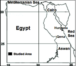 | Figure 1. Location map of the studied area |
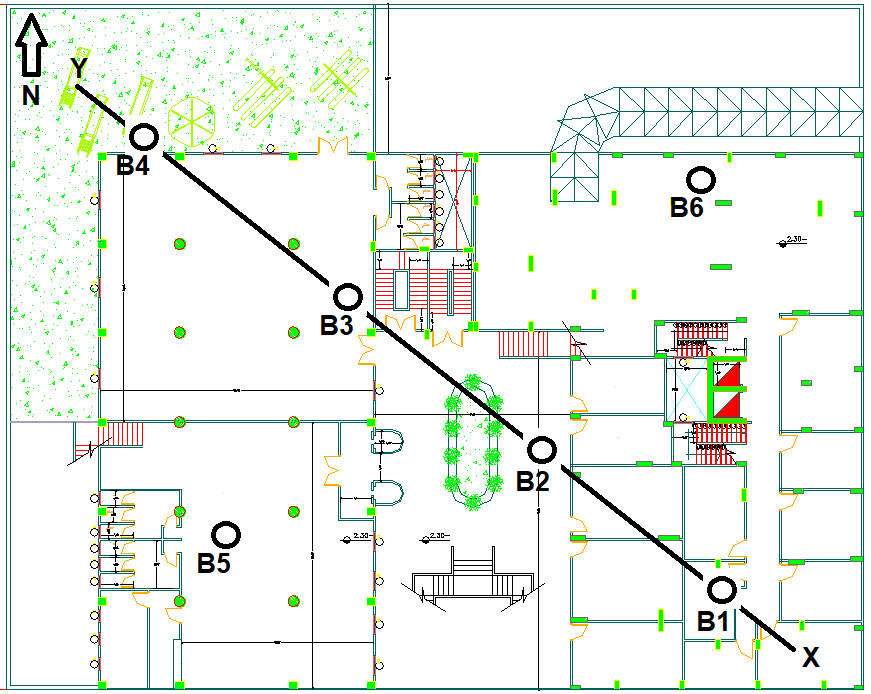 | Figure 2. Layout of the studied project illustrated the studied boreholes (B1 to B6) |
1.1. Previous Works
- The investigated area was geologically studied by several authors. Some sedimentlogical and stratigraphical studies were carried out by [3], [4], and [5]. Structural and tectonics investigations were conducted by [6] and [7]. Some ecological and environmental works were done by [8], [9], [10], [11], [12], and [13]. Earthquakes assessment and geological hazards researches were carried out by [1], [2], [14], [15], and [16]. Few geotechnical studies were done by [17], [18], and [19].
1.2. Scopes of the Present Work
- The above mentioned previous works illustrated that the studied area needs to more geotechnical investigations to evaluate the site soils which contributes to deep understand of the site effect as mentioned in the introduction part and to estimate the earthquakes factors. The present work emphasizes on the assessment of the geotechnical parameters of the investigated soils like gradation parameters, shear parameters (ϕ & Cu), and shear velocity (Vs) to estimate the earthquakes factors of the studied soils and the design ground acceleration (ag) to detect the seismic suitability of the investigated site to construct a large occasions halls building, at Hurghada city, Red Sea, Egypt. The earthquakes factors are including soil coefficient (S), limits of constant value for elastic response spectrum (TB and TC), and specified value for begin of the constant displacement spectrum (TD). The earthquakes factors play an important and basic role in the construction process. These values will be applied by the civil engineer to calculate the total base shear due to earthquakes (if happened) to determine the type and the characteristics of the project foundations and to prevent the possible seismic hazards. The study also interests to calculate an allowable bearing capacity of the studied soils.
1.3. Geological Setting
- The studied area is located along the Red Sea coast at Hurghada city. The area has variety of sediments belonging to the Miocene-Pliocene succession as well as the Quaternary deposits. The area is covered by Quaternary deposits like Wadi deposits, raised beaches sands, and alluvial fan deposits [20]. Shagra Formation (Sandstones) belonging to Miocen-Pliocen age, Um Mahara Formation (Reefal and Carbonate rock with bioclastics) belonging to Miocene age, and basement complexes belonging to Pre-Cambrian age are exposed at the studied area. The basement complexes are including older and younger granites as well as Hammamate clastics (Sandstones and Siltstones) occurred in the southeast direction of the studied area. The investigated soils are representative of Quaternary raised beaches sands and alluvial fan deposits. The distribution of the studied sediments is illustrated in Figure 3. The studied area is characterized by a simple topography. It is dissected by many wadies (valleys) like Wadi Faliq el Sahl which runs from southwest to northeast direction depending on the direction of fault strikes. These wadis are structurally controlled. The current study area is located in the recently unstable tectonic zone which parallel to the Red Sea coast.
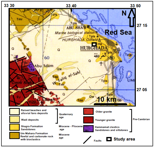 | Figure 3. Geological map of the studied area modified after [20] |
2. Materials and Methods
2.1. Materials
- Sixty disturbed samples were collected from six wash mechanical drilling boreholes (B1 to B6); the maximum depth of the studied borehole is ten meter, one sample was collected in each one meter depth (Figure 2 & 4). The investigated soils were belonging to the Quaternary raised beaches sands and alluvial fan deposits.
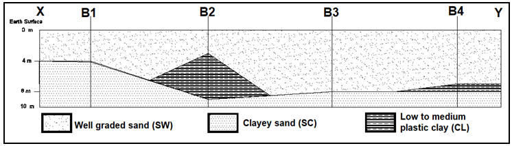 | Figure 4. Cross section in the studied project area along XY-direction |
2.2. Methods
- Subsurface exploration wash mechanical drilling based on [21] was done to achieve six boreholes (10 m depth) and to collect the studied samples. Standard penetration test (SPT) was conducted depending on [21] to measure the frictional angle (ϕ) and the cohesion (Cu) value (in the field) and to calculate the young modulus (Es) of the studied sand samples. Other geotechnical tests including grain size analysis (to classify the studied soils), tri-axial shear test [21] (to measure the frictional angle (ϕ) and the cohesion (Cu) value (in the laboratory), and shear velocity (Vs) using JAMES instrument [22] (to measure the shear velocity (Vs) value) were carried out on the studied samples.
3. Results
3.1. Wash Mechanical Drilling Results
- After the end of the drilling process, identification and description of the studied samples were done and correlation between four boreholes data (B1, B2, B3, and B4) was carried out to achieve a vertical cross section of the studied area in XY-direction. The lithology of B5 and B6 was similar to B3. The data illustrated that the area under investigation composed of two soils layers. The upper layer composed of well graded sands (SW), its thickness ranging from 3 to 7 m, and the lower soils layer composed of clayey sands (SC), its thickness ranging from 1 to 6 m. The cross section contains clays (CL) lens at the borehole no. 2 (5 m thickness) and clays (CL) tongue at the borehole no. 4 (1 m thickness) (Figure 4). The underground water level was recorded at two meters depth in all the studied boreholes.
3.2. Grain Size Analyses Results
- Figure 5 illustrated the grain size distribution curves of the studied soils samples. There were three soil types, the first type was well graded sands (SW) and represented by the upper soil layer where the gradation parameters of the studied sands including coefficient of uniformity were more than 6 according to unified soil classification system (USCS). The second soil type was clayey sands (SC) based on USCS and represented by the lower soil layer. The third soils type was low plastic clays (CL) after USCS and represented by the lens (at B2) and the tongue (at B4). The studied SW-samples composed mainly of sand size (mixed of fine to medium sands as well as coarse sands) ranging from 85 to 87% and trace of silt size ranging from 3 to 5% as well as some of fine gravels equal to 10%. The clayey sands composed mainly of 55% sand size, 25% clay and silt size, and 20% fine gravel size. The low plastic clay composed mainly of 63% clay size and 37% silt size.
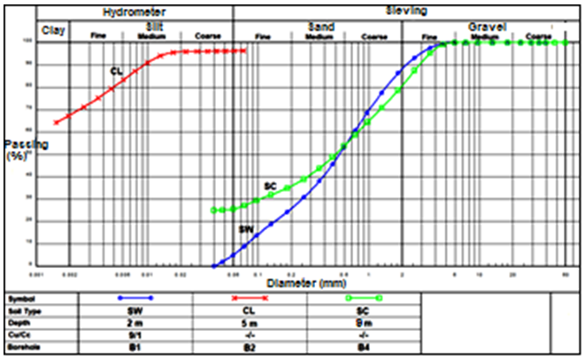 | Figure 5. Grain size distribution curves of the studies soils samples |
3.3. Shear Wave Velocity Test (Vs) Results
- The velocity test results indicated that the shear wave velocities (Vs) of the studied sand samples molded in cylinder (5 cm diameter * 10 cm length) at the natural dry density were relatively low and ranging from 130 to 148 m/s.
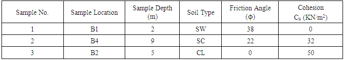
3.4. Tri-axial Shear Test (ϕ & Cu) Results
- The tri-axial shear test was carried out in the laboratory to measure the frictional angle (ϕ) and the cohesion (Cu) of the soils samples under investigation. Three different samples including well graded sands, clayey sands, and low plastic clays were collected from borehole no. 1, 4, and 2. The samples were molded at the natural dry density in cylinder (5 cm diameter * 10 cm length) and tested based on [21]. The results were listed below in Table 1. The results showed that the frictional angle values of the studied well graded sands, clayey sands, and low plastic clays samples were 38, 22, and 0° respectively. The results showed also that the cohesion values (Cu) of the studied well graded sands, clayey sands, and low plastic clays samples were 0, 32, and 50 KN/m2 respectively.
|
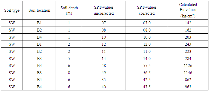
3.5. Standard Penetration Test (SPT) Results
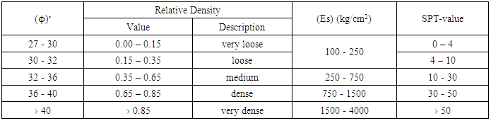
- Standard penetration tests (SPT) were conducted (in the field), associated to the borehole wash mechanical drilling, on the studied sands beds based on [21] using blow weight equal to 62.5 kg and drop height equal to 76 cm, the blow numbers (Nspt) measured each 30 cm penetration. SPT-values were ranged from 7 to 49 blow number each 30 cm penetration. The surface loose well graded sands (at the first meter depth) have the lowest values ranging from 7 to 10. The greatest values were ranging from 35 to 49 at 6 to 8 meters depth and described as dense sands. Intermediate SPT-values were recording and ranging from 11 to 14 and described as medium dense sands (at depth ranging from 2 to 5 meters). The relationship between the SPT-values, the relative densities, the frictional angles, and the young modulus of soils based on the Egyptian code was illustrated in Table 2. Depend on the corrected SPT-values, the young modulus (Es-values) of the studied sand samples can be calculated. The results showed that the Es-value of the studied sands samples occurred at the first meter depth was ranging from 142 to 203 kg/cm2. The Es-value of the investigated sands samples occurred at two to five meters depth was ranging from 223 to 284 kg/cm2. The Es-value of the samples occurred at six to eight meters depth was ranging from 862 to 1146 kg/cm2.
|
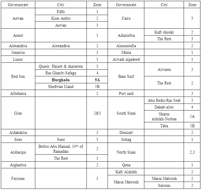
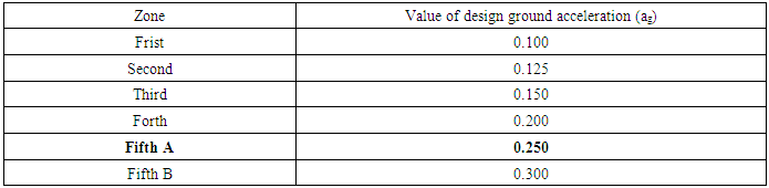
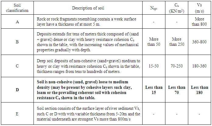
4. Assessment of Earthquakes Factors
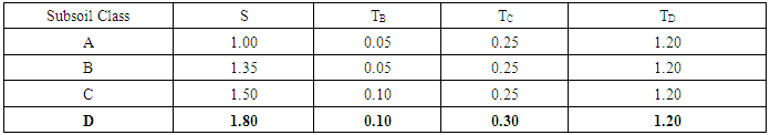
- Earthquakes factors were assessment after [23]. The area under investigation at Hurghada city is located in the seismic zone no. 5A (Figure 6 & Table 4). The value of design ground acceleration (ag) at seismic zone no. 5A is 0.25 g (Table 5). The results pointed to that the investigated soil layer type was class D, where the number of blow each 30 cm was less than 15 (ranging from 11 to 14) at the drill depth of the shallow foundation equal to 4.5 m (as in the recommendation) according [21] and the cohesion values of the sand soil was less than 70 KN/m2 (equal to zero for sands layer) as well as Vs-value was less than 180 m/s (ranging from 130 to 148 m/s), see Table 6. According to the soil layer type (class D), the earthquakes factors including S, TB, TC, and TD were 1.80, 0.10, 0.30, and 1.20 respectively (Table 7). Based on Egyptian code for vibration and dynamic load foundations, the project area under investigated was classified as high potential seismic.
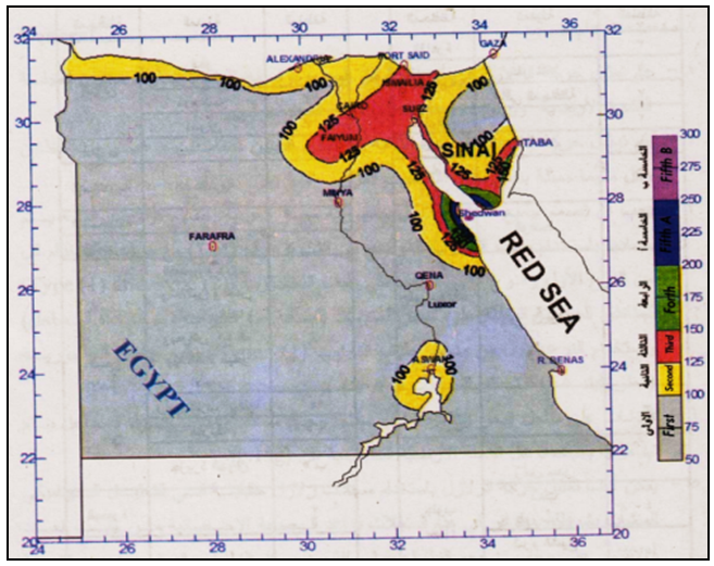 | Figure 6. Seismic activity zones in Egypt |
|
|
|
|
|
5. Assessment of Allowable Bearing Capacity of the Studied Sand Soils
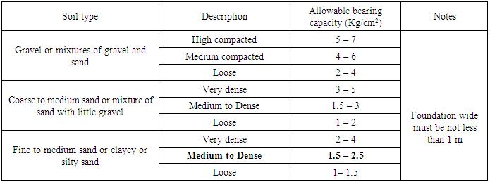
- Based on the Egyptian code of shallow foundations, (in case of dry soil where pore water pressure equal to zero, that means the study area must be carefully dewatered), the allowable bearing capacity of the studied medium to dense sands at the designed drill depth (4.5 m) of the shallow foundations was ranging from 1 to 1.5 kg/cm2 (At shallow foundation wide must not be less than 1 m). Table 8 illustrated the allowable bearing capacity after [24] in dry conditions for soils.
|
6. Discussions, Conclusions and Recommendations
6.1. Discussions and Conclusions
- The investigated soils at the study area are composed of Quaternary raised beaches sands and alluvial fan deposits. The assessment of the geotechnical parameters of the investigated soils like gradation parameters, shear parameters (ϕ & Cu), and shear velocity (Vs) was to estimate the earthquakes factors of the studied soils and the design ground acceleration (ag) to detect the seismic suitability of the investigated site to construct a large occasions halls building, at Hurghada city, Red Sea, Egypt. The earthquakes factors are including soil coefficient (S), limits of constant value for elastic response spectrum (TB and TC), and specified value for begin of the constant displacement spectrum (TD). The earthquakes factors play an important and basic role in the construction process especially at the area having high potential seismic activity. These values will be applied by the civil engineer to calculate the total base shear due to earthquakes (if happened) to determine the type and the characteristics of the project foundations and to prevent the possible seismic damages. The current study also interested in calculation the allowable bearing capacity of the studied soils. To achieve these objectives, sixty disturbed samples were collected from six wash mechanical drilling boreholes (10 m depth). Grain size analyses, shear wave velocity, tri-axial shear, and standard penetration tests were carried out on the soils samples under investigation. There were three soil types, the first type was well graded sands (SW) and represented by the upper soil layer where the gradation parameters of the studied sands including coefficient of uniformity were more than 6 after unified soil classification system (USCS). The second soil type was clayey sands (SC) based on USCS and represented by the lower soil layer. The third soils type was low plastic clays (CL) after USCS and represented by the lens (at B2) and the tongue (at B4). The studied SW-samples composed mainly of sand size ranging from 85 to 87% and trace of silt size ranging from 3 to 5% as well as some of fine gravels equal to 10%. The clayey sands composed mainly of 55% sand size, 25% clay and silt size, and 20% fine gravel size. The low plastic clays composed mainly of 63% clay size and 37% silt size. SPT-test results showed that the surface loose well graded sands (at the first meter depth) have the lowest values ranging from 7 to 10. The greatest values were ranging from 35 to 49 at 6 to 8 meters depth and described as dense sands. Intermediate SPT-values were recording and ranging from 11 to 14 and described as medium dense sands (at depth ranging from 2 to 5 meters). The shear wave velocity values were ranging from 130 to 148 m/s. The friction angle values of the studied well graded sands, clayey sands, and low plastic clays samples were 38, 22, and 0◦ respectively. The results showed also that the cohesion values (Cu) of the studied well graded sands, clayey sands, and low plastic clays samples were 0, 32, and 50 KN/m2 respectively.Based on the Egyptian code for vibration and dynamic load foundations, the area under investigation is located in seismic zone no. 5A. The ag-value was 0.25 and the earthquakes factors including S, TB, TC, and TD were 1.80, 0.10, 0.30, and 1.20 respectively. The project area under investigation was described as high potential seismic and that leads to that the potential for liquefaction of the studied sands is great during seismic shaking (if happened). According to the Egyptian code of shallow foundations, (in case of the dry soil and the pore water pressure equal to zero), the allowable bearing capacity of the studied medium to dense sands was ranging from 1.5 to 2.5 kg/cm2. The underground water level was at two meter depth at the study area that means the study area must carefully be dewatered using safety method to reduce the pore water pressure to zero. The Es-value of the studied sands samples collected from the first meter depth was ranging from 142 to 203 kg/cm2 and described as loose sands. The Es-value of the investigated sands samples occurred at two to five meters depth was ranging from 223 to 284 kg/cm2 and described as medium dense. The Es-value of the sands samples occurred at six to eight meters depth was ranging from 862 to 1146 kg/cm2 and described as dense sands. The Es-values are important and essential values for the civil engineer to calculate the allowable settlement of studied soils under the foundations.Finally this work is just a contribution and trying to bind between the geotechnical investigations and the earthquakes studies to deep understand the site effect including the soil type and its geotechnical behavior and its role in the seismic hazards assessment of the building construction at the study area.
6.2. Recommendations
- In case of shallow foundations application: 1- Structural mat shallow foundations with increasing the weight and the thickness of reinforced concrete were recommended. 2- Dewatering the area under construction using safety method. 3- Based on the Egyptian code for shallow foundations, it was recommended that, the minimum drill depth of shallow foundations must not be less than 4.5 m. 4- Replacement the clayey sands at borehole no. 1 and the clays at borehole no. 2 with imported well graded gravels. The thickness of the imported well graded gravels must be not less than 100 cm. 5- Compaction of the imported well graded gravels, in four layers each layer having 25 cm thick; to obtain at least 97% of the maximum modified proctor density.In case of deep foundations application: Deep (pile) foundations were recommended, with high resistance for the total base shear forces which due to earthquakes (if happened).
ACKNOWLEDGEMENTS
- Special thanks for the owner of the project for valuable cooperation.