-
Paper Information
- Paper Submission
-
Journal Information
- About This Journal
- Editorial Board
- Current Issue
- Archive
- Author Guidelines
- Contact Us
World Environment
p-ISSN: 2163-1573 e-ISSN: 2163-1581
2015; 5(3): 121-133
doi:10.5923/j.env.20150503.04
Characteristics and Vulnerability of Houses under Overhead High-Tension Powerline in Akure, Nigeria
 Abstract
 Reference
 Full-Text PDF
 Full-text HTML
Isaac Oluwadare Olamiju, Michael Ajide Oyinloye
Department of Urban and Regional Planning, School of Environmental Technology, Federal University of Technology, Akure, Nigeria
Correspondence to: Michael Ajide Oyinloye, Department of Urban and Regional Planning, School of Environmental Technology, Federal University of Technology, Akure, Nigeria.
| Email: |  |
Copyright © 2015 Scientific & Academic Publishing. All Rights Reserved.
This study combines the social survey research method with GIS analysis, using remotely sensed data, to assess the characteristics of residents and vulnerability of houses under the 330KV overhead powerline in Akure, Nigeria. The powerline runs across Akure from North-East through the South-East over a distance of about 10km. The ArcView GIS software was used to create 30m and 60m buffers on both sides of the facility, which identified 126 buildings encroaching on the setback. Empirical analysis shows that: 68 and 58 buildings in the corridor are vulnerable and highly vulnerable to health hazards of electromagnetic radiation respectively; over 60% of buildings in the corridor are of the face-to-face/roomy type, which is usually associated with low income earners; the average age of respondents is 37 while the mean household size is 5. Over 60% of respondents are traders and artisans; while only 16.0% of them have no formal education. This paper recommends: an awareness and re-orientation program for residents of powerline corridors and other marginal lands in Akure; a total clearance of all the encroaching buildings in the corridor and resettlement of all affected households is canvassed for sustainable urban development.
Keywords: High-tension, Powerline, GIS, Remote Sensing, Sustainable Development
Cite this paper: Isaac Oluwadare Olamiju, Michael Ajide Oyinloye, Characteristics and Vulnerability of Houses under Overhead High-Tension Powerline in Akure, Nigeria, World Environment, Vol. 5 No. 3, 2015, pp. 121-133. doi: 10.5923/j.env.20150503.04.
Article Outline
1. Introduction
- The world is increasingly becoming urbanized and the rate at which city populations grow and countries urbanize is indicative of the pace of social and economic change [4]. In the year 1800, London was the only city in the world with a population of a million people, while the 100 largest cities altogether had a population of only 20 million. By 1990 the world’s largest 100 cities had a combined population of 540 million with 220 million of these living in the twenty largest cities [26]. In 2006, the world urbanization figure rose beyond 3.3 billion constituting about half of the entire humankind; and by the target year for the Millennium Development Goals (MDGs); cities in the world are estimated to grow to two-third or 6 billion people by 2050 with most of such taking place in developing countries [29].Thus, the importance of cities has increased significantly over the centuries, and the current dramatic growth of urban populations is seen as critical to the future of Earth by some. The development from village and rural life to urban civilization has had both social and environmental impacts; the growth of urban populations and associated industrialization has resulted in a range of detrimental and often de-humanizing outcomes [4]. The population explosion brought about by massive institutional, industrial, commercial and infrastructural development in Akure led to a wide range of urban problems which include acute housing shortage, poor street layout with little or no consideration for setbacks and open spaces, traffic congestion, disease outbreaks, infrastructural break-down and widespread environmental deterioration and pollution as well as encroachment on marginal lands [4], [8], [15].The population of Akure was put at 38,852 in 1952. In 1961, the population of Akure was 71,000; 109,000 in 1980; 112,000 in 1981; 114,000 in 1982, 117,000 in 1983; 120,000 in 1984; and 123,000 in 1985 [20]. The population of Akure at 1991 was 239,712 people. The National Population Projection for the year 1996 and 2000 put the Akure population at 269,207 and 298,712 respectively [20]. A sharp increase was recorded in 2006 with a population of 353,211 [20]. From the above statistics, it is evident that Akure has been witnessing steady increase in population since 1952. This phenomenal increase in population had hitherto increased land value and demand for land at the suburb and rural-urban fringes of the city [21]. In addition, marginal lands such as river floodplains, mountain tops and set back to electric powerline had been encroached upon due to increase in population and land value [22]. This paper is set to delineate the 330KV overhead powerline corridor in Akure using GIS method; investigate the characteristics of houses and residents in the corridor; and their vulnerability to hazard of electromagnetic radiation with a view to protecting health of residents and ensuring sustainable urban development in the study area.
2. Data and Methods
- The Study Site: The study area is Akure, the administrative capital of Ondo State since 1976. Akure is situated on latitude 7°17’ N and longitude 5° 4’ E of the Greenwich Meridian. It is about 370m above the mean sea level. Akure is situated within a 48 kilometre radius to major towns in Ondo State which are Ondo to the South, Owo to the East and Iju/ItaOgbolu to the North. The area towards Ado – Ekiti and Idanre are hilly and studded with large granite formation, rising to 410 metres and 496 metres above sea level respectively. The easy access and geographical centrality of Akure to nearby towns such as Ondo, Owo, Ilesa and Ado-Ekiti., have enhanced the growth prospects of the city. Okoko (2002) asserted that, the influx of people into the town was necessitated by the development attracted to Akure as a state capital. With the presence of government seat in Akure, job opportunities, provision of community and social facilities enhanced the migration of youths from the surrounding towns/settlements for job opportunities resulting in rapid population increase.According to the 1991 census count, the population of Akure was 239,124 which was projected by the National Census Board to 269,207 in 1996. In 2006, the population had increased to 3,441,024 with 1,761,263 male and 1,679,761 female, which represent 2.46% of the total population of Nigeria. The current estimated population of Akure at the annual growth rate of 3.18 is 413,060 [20]. Improvements in transport facilities were given prominence in Akure shortly after 1976 when the city became the seat of government. The multifarious activities, performed by Akure, influence the desire to construct new roads and rehabilitate the old ones to take care of the envisaged new roles and status of the city. Thus, houses were demolished along major roads, to accommodate dual carriage ways.Akure is made up of two Local Government Areas (LGAs), namely: Akure North and Akure South with corresponding land area coverage of 676.7 km2 and 318.0 km2 respectively. Each of these Local Government Areas constitutes a sub-region that forms the Akure region. This region is an integral part of a larger political region called Ondo State of Nigeria [24]. Figures 1-3 shows the study area in its national, regional and local settings.
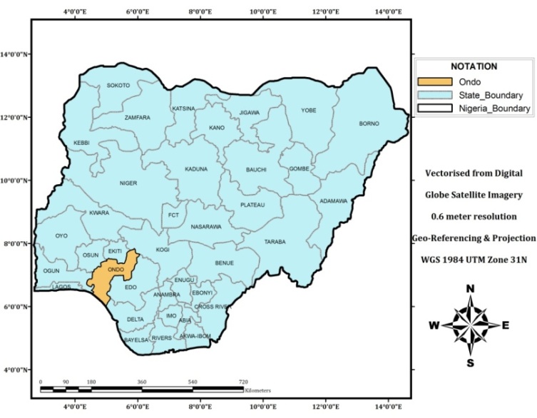 | Figure 1. Map of Nigeria showing Ondo State. Source: Google Satellite Imagery, digitized by Authors using ArcGIS (2014) |
 | Figure 2. Map of Ondo State showing Akure-South Local Government Area. Source: Google Satellite Imagery, digitized by Authors using ArcGIS. (2014) |
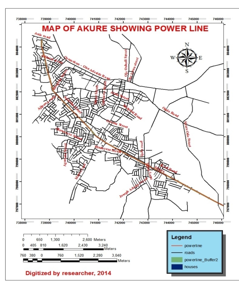 | Figure 3. Map of Akure Showing the 330KV Powerline. Source: Google Satellite Imagery digitized by Authors using ArcGIS. (2014) |
3. Literature Review
- Landuse change occurs when the use of which land is put is different from what it was in the past. For instance, an open space or forested area could turn into a built-up area. Therefore, landuse and land cover changes play an important role in local and regional environmental condition of a particular territory and they are linked to global environmental change. Cities in most developing countries like Nigeria have been undergoing unprecedented changes both in population and spatial extent and as a result are faced with a variety of problems such as uncoordinated land development, conflicting land uses, high densities in certain parts of the urban area and the absence of adequate road network which could ensure intra-urban mobility within the city [1].There is frequent displacement of residents of contemporary prime areas which hitherto at the fringe of the cities without alternative accommodation or land in Nigeria [26]. He further notes that Land Use Act and concept of public interest should be forward looking and based on factors of public interest such as health, safety, convenience, efficiency, energy conservation, environmental quality, social equity, social choice and amenity.The intrusion of new land use into existing use of land [21]. He observed that the history of American cities is the story of invasion of one land use by another. The resultant taking-over of the existing land use by the new one is called “succession”. He argued that as cities grow, areas that were once characterized by single-family houses were converted to apartment, and that a viable city is always in the process of change and cities that do not change become historical tourist attractions or stagnant backwaters. Intrusion is the penetration of one population group or land use by another owing to economic, social and cultural deviance between the old and new [21]. He posited that succession occurs after invasion, asserting that succession is the peak of invasion and it arises when the new group or land use eventually overruns the old use of the area. The consequences of invasion, according to him are shifts in land use and consequently break-up of existing order.Land resources tend to move to those operators who bid the most for their control and to those uses that offer the highest return for their utilization. Succession process is a dynamic process that calls for adjustment to changing demands and changing technology. As cities develop houses and stores are built in cow pastures and cornfield of yester years, new streets are built and as these cities prosper and expand, costly development become desirable. Streets that were suitable for house and buggy traffic must be widened and re-laid sewers and dry up and enlarged stores are rebuilt and houses are torn down to make way for new commercial developments. The above assertions suggest that invasion and succession, a common feature of change-in-use, is synonymous with the growth of urban centers. Thus, it may be a measure of growth and may not be inevitable, only calling for control and management. Also succession may be a feature of the practice of free-enterprise as land is allocated in the free market [5].Land use conflict in a way limit what the private owners of land could do. Conversions of land use has resulted in rapid emergence of slum areas housing many urban dwellers, poor planning and inefficiently managed urban and rural infrastructure and public services. Indeed, these affect the physical blight and appearance of cities and of course the quality of life of the inhabitants [26].
3.1. Vulnerability and Electromagnetic Radiation
- Vulnerability refers to the inability to withstand the effects of a hostile environment. A window of vulnerability (WoV) is a time frame within which defensive measures are reduced, compromised or lacking. In relation to hazards and disasters, vulnerability is a concept that links the relationship that people have with their environment to social forces and institutions and the cultural values that sustain and contest them. “The concept of vulnerability expresses the multi-dimensionality of disasters by focusing attention on the totality of relationships in a given social situation which constitute a condition that, in combination with environmental forces, produces a disaster”[7]. Vulnerability research covers a complex, multidisciplinary field including development and poverty studies, public health, climate studies, security studies, engineering, geography, political ecology, and disaster and risk management. This research is of importance and interest for government and organizations trying to reduce vulnerability – especially as related to poverty and other Millennium Development Goals. For instance, Goal 7 of the MDG seeks to ensure environmental sustainability. Nigeria’s rich environmental resource base is being undermined by deforestation (3.5% per annum), erosion, desertification, gas flare and oil production (MDG Advocacy Group). Encroachment on hazard zones is unsustainable hence the need for this study. Many institutions are conducting interdisciplinary research on vulnerability. A forum that brings many of the current researchers on vulnerability together is the Expert Working Group (EWG). Researchers are currently working to refine definitions of “vulnerability”, measurement and assessment methods, and effective communication of research to decision makers [8].In military terminology, vulnerability is a subset of survivability, the others being susceptibility and recoverability. Vulnerability is defined in various ways depending on the nation and service arm concerned, but in general it refers to the near-instantaneous effects of a weapon attack. In aviation it is defined as the inability of an aircraft to withstand the damage caused by the man-made hostile environment [6]. There is no doubt that electrical devices create electrical or magnetic fields, often called EMFs. Human exposure to EMFs has increased dramatically in modern times; and many people have worried that this is a bad thing. A correlation between high-voltage power lines and childhood leukemia in the area around Denver, Colorado. “Static electric and magnetic fields and extremely low-frequency electric fields are not classifiable as to their carcinogenicity to humans” [30]. In other words there is no any positive evidence that EMFs cause cancer. About 50% of the public exposed to EMR would be sensitive to the radiation effects by 2017 [28]. The manifestation of this hypersensitivity would be health complains such as headaches, giddiness, nausea, skin rashes, feeling warm, depression, night sweats, memory loss, disturbances in menstruation and insomnia [28]. Studies show that people living in the vicinity of electric powerlines develop adverse health conditions especially the non-specific health symptoms and cancer [9], [10], [15], [27]. In a recent study conducted on over 50,000 cases of cancer, including leukemia, brain cancer, breast cancer, skin cancer, and others found no increased risk for any of these cancer types and concluded that there is no epidemiologic association of adult cancers with residential magnetic fields in proximity to high-voltage overhead power lines [13].The scientific literature and the reports of reviews by other panels show no consistent, significant link between cancer and the powerline fields. This literature includes epidemiological studies, research on biological systems, and analyses of theoretical interaction mechanism. No plausible biophysical mechanisms for systematic initiation or promotion of cancer by this powerline fields have been identified. Furthermore, the preponderance of the epidemiological and biophysical/biological research findings have failed to substantiate those studies which have reported specific adverse effects from exposure of such fields [2]. Based on a comprehensive evaluation of published studies relating to the effect of power frequency, electric and magnetic fields on cells, tissues, and organisms (including humans), the conclusion of the committee it that the current body of evidence does not show that exposure to these fields presents a human-health hazard. Specifically, no conclusive and consistent evidence shows that exposures to residential electric and magnetic fields produce cancer, adverse neurobehavioral effects, or reproductive and developmental effects [17].In 1997, the National Cancer Institute produced the largest epidemiological study to date, which found no association between childhood leukemia and either wiring codes or measured magnetic fields [16].The New England Journal of Medicine published the results together with an editorial calling for an end to wasting money on EMF research [12]. Despite these findings, the World Health Organisation have published a fact sheet maintaining that there is limited for childhood leukemia (insufficient for casualty). However, it is also important that causality is not required for precautionary action, so this statement should not affect government decision to apply more precautionary public policy where they deem appropriate.
4. Findings
- The GIS analysis results are as presented in the following sections:
4.1. Buffering Analysis on the Powerline Corridor
- A 30m and 60m buffer on both sides of the powerline corridor was carried out. Within the 30m buffer, 58 buildings were identified while additional 68 buildings fall within the 60m buffer of the powerline corridor. Summarily, one hundred and twenty-six (126) buildings fall within the buffers. The analysis of buildings within the buffered corridor is as shown in Table 1.
|
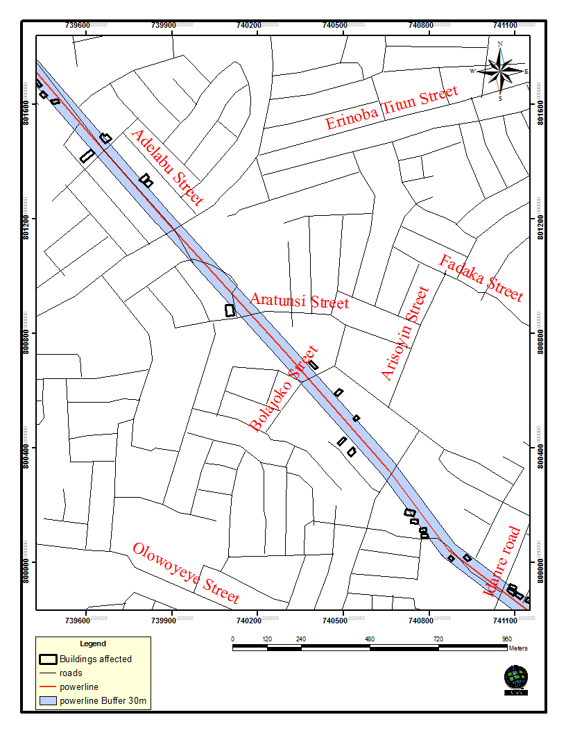 | Figure 4. A Section of the 30m Buffer along the 330KVA Powerline Corridor in Akure, Nigeria |
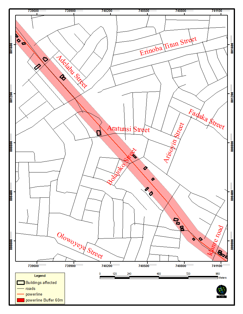 | Figure 5. A Section of the 60m Buffer along the 330KVA Powerline Corridor in Akure, Nigeria |
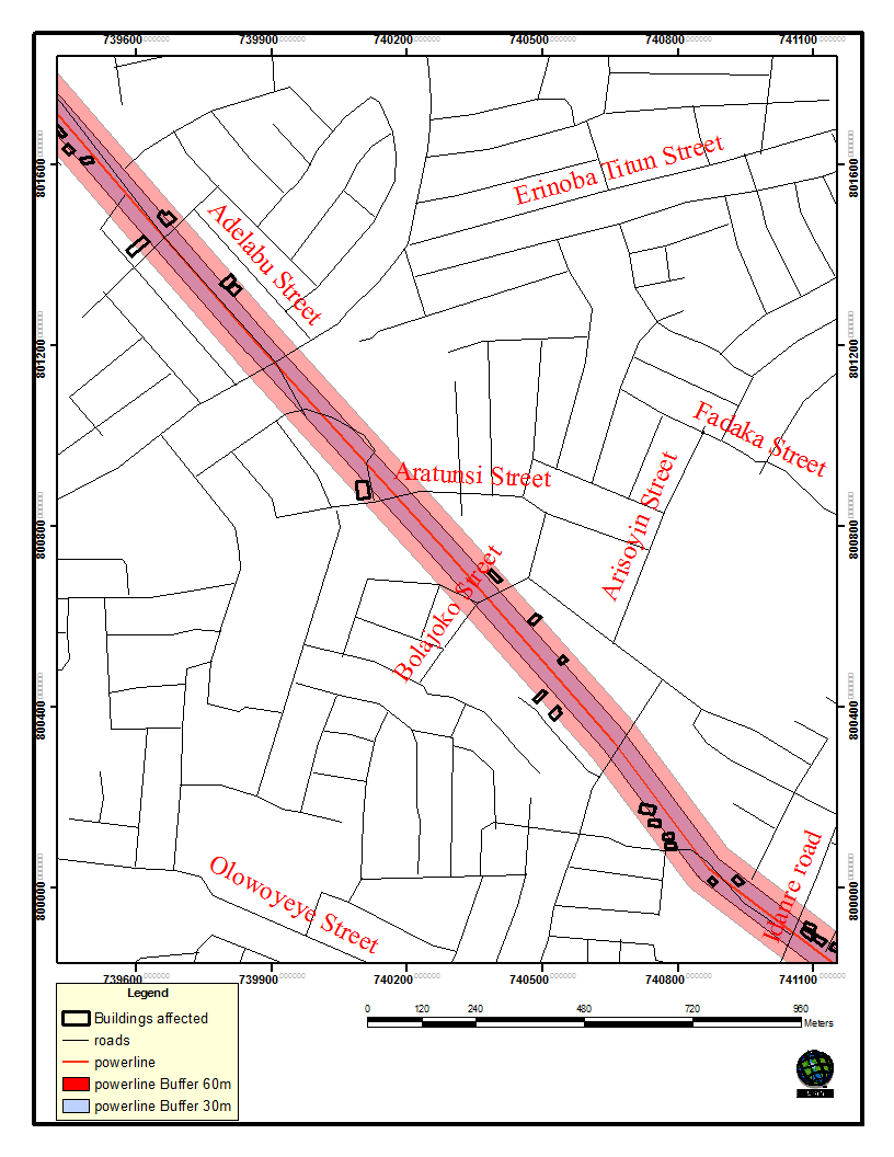 | Figure 6. A Section of the Combined 30m and 60m Buffers along the 330KVA Powerline Corridor in Akure, Nigeria |
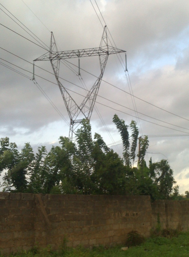 | Plate 1. Powerline Mast inside a Residential Building. Source: Authors’ Fieldwork, 2014 |
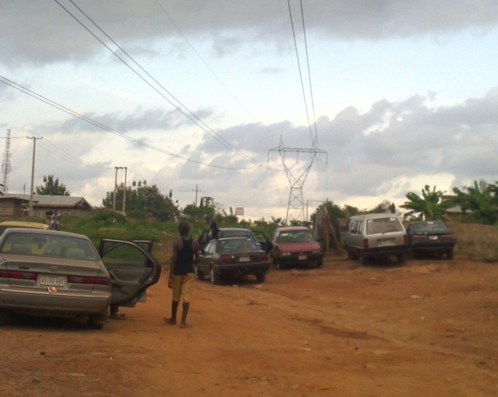 | Plate 2. A Mechanic Workshop Directly under 330 KVA Electric Powerline. Source: Authors’ Fieldwork, 2014 |
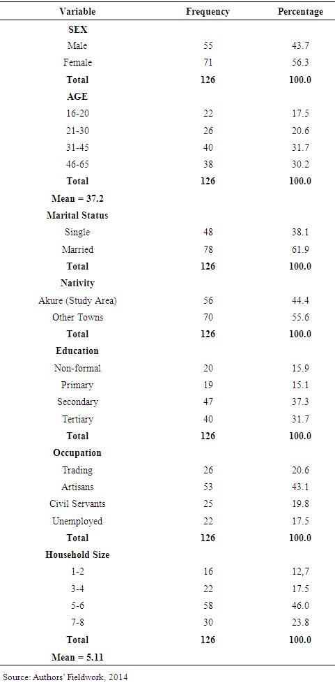
4.2. Socio-economic Characteristics of Respondents
- From Table 2, it is obvious that female household heads (53.6%) are more than male household heads (43.7%) in the study area. This finding agrees that stated women are more than men in Nigeria [20]. In addition, the preponderance of the female folk over their male counterpart inhabiting marginal land in Akure is a reflection of female marginalization in access to legal land in the study area [5]. This phenomenon, as opined by UNCHS is a violation of human right and contributes significantly to women’s increasing poverty [29]. The author also noted that women (including poor female household heads that are divorced, widowed, single working mothers and separated) are vulnerable group particularly in the area of land and housing resources. Furthermore, About 60% of respondents are above the age of 30 years. The average age stood at 37. The implication is that a greater proportion of the active population who are migrants in Akure are not properly accommodated.
|
|
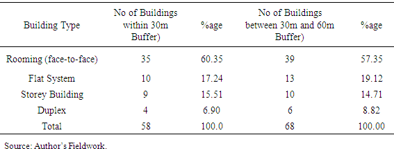
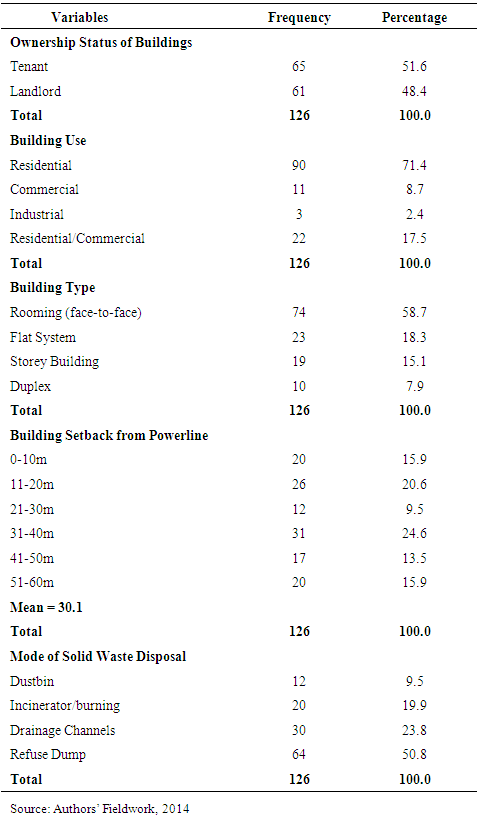
4.3. Characteristics of Buildings in the Study Area
- Housing as one of the most important basic necessities of mankind is known to tremendously affect human health and wellbeing [11]. On this note, the building characteristics in the study area were examined and the result is as summarized in Table 4.
|
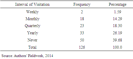
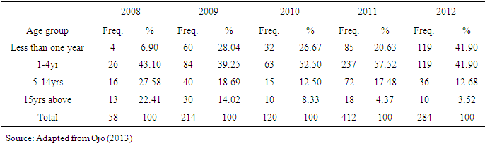
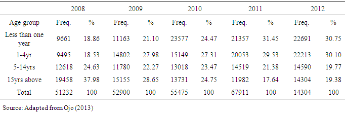
4.4. Health Assessment of Respondents
- The Health condition of respondents along the powerline was analysed. Specifically, the rate and frequency of their visitation to hospitals/clinics for treatment was looked into. The table below shows respondents rate of visitation to Health Centres.
|
|
|
5. Conclusions and Recommendations
- From this study, it is apparent that: there is inadequate monitoring of physical development along the powerline corridor; the powerline corridor is mostly occupied by the poor due to their inability to secure land conveniently and legally; residents are also ignorant of the actual setback from the powerline and the risk associated with living very close to it. Based on the findings, this paper recommends that the Development Control Department (DCD) should embrace the use of Global Positioning System (GPS) and Geographic Information System (GIS) technologies, as applied in this study, for accurate monitoring of development in the study area. The powerline corridor within the city landscape should be properly fenced using special trees/walls as applicable in order to prevent further encroachment. It is also in the opinion of this paper that the general public be enlightened through Environmental Education (EE) to seek plan approval from the appropriate planning authority before erecting any development; and plan approval charges should be made friendlier so that people can easily afford it. The DCD should be provided with adequate logistics to properly carry out its functions. To cap it all, the governments of Ondo State and Akure South Local Council should provide affordable low cost housing estates for low income earners in the city using the Shagari Low Cost Housing Model of 1979.