Adegoke Kayode Martins1, Bulus Luka Gadiga2
1Department of Surveying and Geomatics, Federal Polytechnic, Mubi, Nigeria
2Department of Geography, Adamawa State University, Mubi, Nigeria
Correspondence to: Adegoke Kayode Martins, Department of Surveying and Geomatics, Federal Polytechnic, Mubi, Nigeria.
| Email: |  |
Copyright © 2015 Scientific & Academic Publishing. All Rights Reserved.
Abstract
The morphometric analysis of the upper Yedzaram catchment is evaluated using the drainage system. This research focuses on the hydrological and geometrical analysis with emphasis on the morphometric characteristics of the catchment such as the Watershed Analysis, Bifurcation Ratio which forms the linear properties, Stream Order (Nu), Stream Length (Lu), Drainage Density (D), Stream Frequency (Fs), Texture Ratio (T), Elongation Ratio (Re), Basin Relief and Basin Ratio. A total number of 61streams were determined in which 17 are 1st Order, 19 are 2nd Order, 18 are 3rd Order, 6 are 4th Order and 1 is 5th Order streams. The bifurcation Ratio value of the catchment is 2.74 while the total stream length is 161.97 km with total area coverage of 191.17 sq. km. The Drainage Density (D) of the study area is 0.85. This tends to associate the low density with high permeable top subsoil and tick vegetation cover. The value indicates that in every square kilometer of the basin, there is 0.85 Kilometer of drainage channel.
Keywords:
Morphometric analysis, Geographic Information System, Watershed, Stream length, Drainage density, Bifurcation ratio, Deforestation
Cite this paper: Adegoke Kayode Martins, Bulus Luka Gadiga, Hydrological and Morphometric Analysis of Upper Yedzaram Catchment of Mubi in Adamawa State, Nigeria. Using Geographic Information System (GIS), World Environment, Vol. 5 No. 2, 2015, pp. 63-69. doi: 10.5923/j.env.20150502.03.
1. Introduction
Morphometric is the mathematical analysis of the earth surface configuration, dimension, shape, and landforms [2]. Geomophology has developed over many year with quantitative physiographic means of depicting the characteristics of drainage network [7].Watershed drainages were made active by surface fluvial runoff which has important biologic, climatic, and geologic effects. The morphometric analysis of watershed gives quantitative description of the system which is of great importance on the hydrological analysis of the system [13] and [3].The drainage basin is the part of the earth surface which is drained by main stream and its tributaries, the geomorphic unit flow of land surface is governed by its properties and it is an open system in which energy flows [9]. Prior to this time, morphometric parameters were measured using mathematical concepts but GIS modules provide flexible environment and powerful tools for integrating, manipulating and analyzing spatial information.Without the morphometric analysis of this catchment, the challenges of environmental management, underground water analysis, engineering project, water pollution and health of the populace will be at risk of environmental mismanagement.Study Area:River Yedzeram is one of the rivers that drain into Lake Chad. It has a total length of about 330 kilometer (Uba Topographic sheet 156, Edition 1., 1974). It takes it source from the Hudu Hills south-east of Mubi and flows northward into the Chad, [1].The study area cut across Mubi North and Mubi South Local Government Area in the Northeastern part of Adamawa State, Nigeria and located between latitudes 10° 11 '30” and 10° 22' 30”N and between longitudes 13° 13' 00’’ and 13° 30’ 00” 'E (figure 1). The drainage basin covers an area of 35.1 kilometer square. However, the section of the channel’s middle course studied covered a length of 30 km2 from Va’atita in Mubi South to Mayo Bani in Mubi North Local government areas.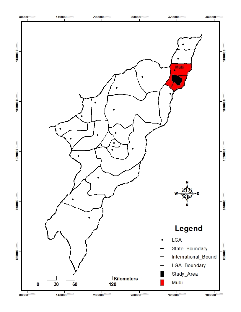 | Figure 1. Map of Adamawa State Showing the Study Area |
Watershed of the catchment:A catchment is defined as the land area that contributes runoff to a given Hydro Edge. Catchments and watersheds are land areas that drain to a Hydro Network. The determination of their boundaries is necessary when modeling a hydrologic system.The relief of the watershed is developed on hard crystalline cratonic basement complex of Nigeria. The hard crystalline form series of orogenic cycles within the mobile belt of Africa [10], and most rock within the catchment are Gneisses, migmatities and quarzites, but laterobliterated by the late proterozoic and pan-Africa events.The predominant geological structures in the area are quartz veins, folds, dykes and sheer zones. The dominanttectonic directions in the area are NW-SE making pre-africa deformation and NE-SW making the thermotectonic event [1]. The soil of the study area falls into the hydromophic and ferruginous tropical soil of granitic material which is made up of Entisols and Inceptisols base on USDA soil order [8].
2. Methodology
The hard copy of topographic map of the study area (UBA topographic map sheet 156 edition 1, 1969) was scanned and saved in TIF format; it was later transfered to the ArcGIS 10.0 user interface where the map was georeferenced and stream networks in their orders were digitized. The streams were classified into fiver (5) ordering technique, the digitized contours was used to produce the Digital Terrain Model (DTM) using the spatial analysis tool through hydrology and the watershed sub tool. The database of the drainage layers of the river basin was created with respect to attribute data of the stream network. The stream order (U), Stream number (Nu), Stream length (Lu), Bifurcation ratio, Drainage density (D), Stream frequency (Fs), Basin relief, Elongation ratio (Re), Circulatory ratio (Rc), Relief ratio and Ruggedness number, Texture ratio were produced using GIS techniques as the basis for the basin analysis.
3. Results and Discussions
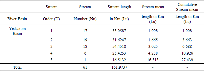
The morphometric parameter analysed for the Yedzaram drainage basin catchment using ArcGIS 10 software are highlighted in Table 1, 2 and 3.Table 1. Linear Aspect of the Drainage Network of the Yedzaram Basin
 |
| |
|
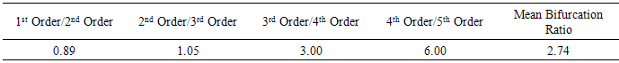
Table 2. Bifurcation Ratio
 |
| |
|
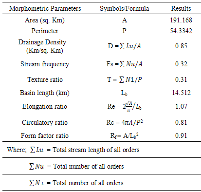
Table 3. Aerial Aspect of the Yedzaram Basin
 |
| |
|
The linear network properties:The linear drainage network aspect of the Yedzaram basin such as the stream order (Nu), Stream length (Lu), Bifurcation ratio (Rb) are highlighted in Table 1 above.Stream Order (Nu):The stream order refers to the hierarchy of streams within an area. Two systems are commonly used, the Strahler and the Shreve but for the purpose of this research, the Strahler system was used which describe stream without tributaries (a finger-tip stream) a first order stream. When two first order streams meet, they form a second order stream and when two second order stream meet, they form a third order stream and so on to form the next higher order of stream [5]. The drainage basin has been ranked into five (5) stream ordering system using ArcGIS 10 as shown in figure 3. The total number of 61streams were identified, 17 first order streams, 19 second order streams, 18 third order streams, 6 fourth order streams and one fifth order stream respectively.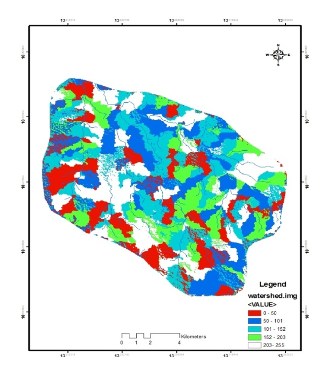 | Figure 2. The watershed of the Upper Yedzaram catchment Basin |
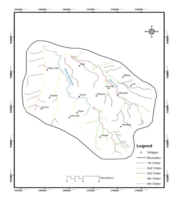 | Figure 3. The Stream order map of the catchment Area |
Bifurcation Ratio (Rb):The word bifurcation ratio is explained as the ratio of streams of a given order to numbers of streams in the next order; the first order is rationalized with the second order, the second order with the third order, these continue till the end of the order [11]. The bifurcation ratio of this research ranges between 0.89 and 6.0. The bifurcation ratio depicts small range of variation for different environmental conditions that dominates and the mean bifurcation ratio value of the studied area is 2.74 as shown in table 2.Stream Length (Lu):Stream length reveals surface runoff characteristics of relatively small areas with larger slopes and finer textures. Streams with long length are generally of flatter gradients. The stream order was queried and stream length was calculated and summed using arcGIS 10 through the measure tool. The geometry progression relationship between the stream order and the cumulative stream length was considered and to have agreed with the Horton’s Law which states that “The cumulative length of stream segment of successive orders tend to form a geometric series beginning with the mean length of the first order segment and increasing according to a constant length ratio” except for the 4th and 5th order which indicate the terrain variation in lithology and topology (Table 1).Aerial Aspects of the Drainage Basin:The aerial aspect of the basin is the area coverage of the extent at which the basin analysis is carried out.Drainage Density:Drainage density is the amount of stream channel length per unit area. Drainage density includes underground water which is important to urban and regions of carboniferous limestone, it is considered to be an important index which measure the texture of the network, and indicates the balance between the erosive power of overland flow and the resistance of surface soils and rocks. Also, a good estimate of gullies development can be determined in any similar lithologic formation using daily rainfall data in any period of time starting from a known drainage network length. Gully erosion contributes to various problems including: the extension of badlands area, the loss of the topsoil, the increase of the drainage network length, and the accelerated decrease of the cropped lands. In this research, the density of the basin ranges between 0.82 and 4.08. The density is highlighted in the figure 4.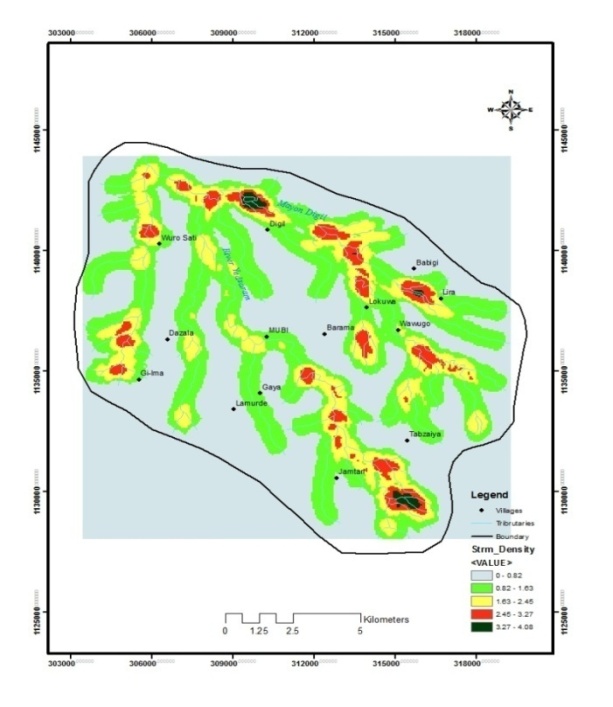 | Figure 4. Drainage Density map of the Yedzaram catchment |
Stream Frequency (FS):The stream frequency or channel frequency (FS) is the total number of stream of the orders per unit area [6] and [5]. The stream frequency for the basin is calculated to be 0.32, this value depict a positive correlation with the drainage density value cumulating into stream population in reference to the drainage density.Texture ratio (T):It is the mophometric drainage factor analysis which depends on the lithology, infiltration capacity of the basin, the texture ratio of the catchment basin is 0.31 which is moderate in respect to the size of the basin and the clay contents of the soil because clay soils hold more water and are slower to drain than the course textured soil. The particle can closely pack together and block space between particles to prevent water from passing through. Sand particles are larger and therefore, have larger pore spaces for water to pass through.Elongation ratio (Re):The circled diameter of the same area as the drainage basin divided by the maximum length of the basin measured from its mouth. It enhances the analysis of hydrological character of a drainage basin. The elongation value for this studied basin is 1.07 which assumes high degree of integration and it is always identified with region of low relief.Basin ratio:It is the ratio between the basin relief and the maximum length of the drainage basin. The basin ratios of the study area depict 1.96 meters.Ruggedness number:The ruggedness number of any basin is the basin relief multiplied by the drainage density of the basin which gives the final result as 3.65.Basin relief:The basin relief of any point is the difference in elevation between the highest and the lowest point in a drainage basin, the highest point of the studied basin is 941 and the lowest point is 511meters above sea level (ASL) as shown in figure 5 below. Thus the basin relief interval for the studied area is 430 meters.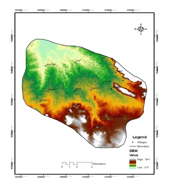 | Figure 5. Map showing the Highest and the lowest relief of the catchment |
4. Conclusions
The morphometric parameters is an immense tools used in evaluating river basin and the watershed preference for soil, conservation of water and resource management at micro level. The analysis carried out for the Yedzaram catchment basin depicts that the basin is tending towards elongated shape. The morphometric analysis is of great importance in hydrological behavior of basin for water quality project, engineering works, public policies applications and flood forecasting, erosion control and environmental management, it is also essential for accurate modeling analysis. The neglect of this will endangers the success of managing the environment. Thus; the texture ratio of 0.3 is moderate because large infiltration into the catchment may require many outlet control device to effectively manage the overflow water during large storm.
References
| [1] | Adebayo and Dayya 2004, Geology, Relief and drainage. In Adebayo A.A. (ed). Mubi region A Geographic Synthesis. Yola: Paraclete Publisher. |
| [2] | Agalwa, C.S (1988) Hydrological Investigation in Bundelkhand Region using Remote Sensing Techniques. |
| [3] | Baker, J.P.; Hulse, D.W.; Gregory, S.V.; White, D.; Van Sickle, J.; Berger, P.A.; Dole, D.; Schumaker, N.H. 2004. Alternative futures for the Willamette River basin, Oregon. Ecological Applications. 14(2): 313–324. |
| [4] | Bassey N.E (2004), Personal Communication Based on an ongoing research on the Geololgy of the Hauwal Basin. |
| [5] | Garret Nagale 2000, 2004. Advanced Geography. New York Oxford. |
| [6] | Horton, H.E. (1932), drainage basin characteristics. Trans. Amer. Geophys. Union 13, 350-61. |
| [7] | Leopold, L.B. and Maddock, T. (1953). The hydrologic Geometry of Streem Channels and some physiographic Implications. |
| [8] | Nwaka G.K. (2004), Soil Resources of Adamawa State and Potentials for Crop production: |
| [9] | Ofomata, M. and J.E. Umeuduji, 2000. New York. Topological Indices of Morphological Transformation in the Aboine Basin. Nigeria Environ. Revolution J., Vol. 1. |
| [10] | Opeloye S.A. and Dio, C.J. (1999), Geology and Mineral Ressources: In Adebayo A.A. and Tukur, A.L (ed). Adamawa State in Maps. Yola Paraclete publishers. |
| [11] | Schumaker, N.H. 2004. Alternative futures for the Willamette River basin, Oregon. Ecological Applications. 14(2): 313–324. |
| [12] | Singh, S., 1998. Physical Geography, Prayag Pustak Transformation in the Aboine Basin. Nigeria Environ. Bhawan, Allahabad, India. Revolution J., Vol. 1. |
| [13] | Strahler, A.H., 1964. Quantitative Geomophology of Drainage Basins and Channel Ntworks In Handbook of Applied Hydrology, McGraw Hill Book Company, New york, Section 4. |
 Abstract
 Reference
 Full-Text PDF
 Full-text HTML