World Environment

p-ISSN: 2163-1573    e-ISSN: 2163-1581

2015;  5(1): 1-11

doi:10.5923/j.env.20150501.01

The Assessment of Ambient Air Pollution Trend in Klang Valley, Malaysia

Siti Rahmah A. Rahman1, Sharifah Norkhadijah S. Ismail1, Muhammad F. Ramli2, Mohd T. Latif3, Emilia Z. Abidin1, Sarva M. Praveena1

1Department of Environmental and Occupational Health, Faculty of Medicine and Health Sciences, Universiti Putra Malaysia, UPM Serdang, Malaysia

2Department of Environmental Science, Faculty of Environment Studies, Universiti Putra Malaysia, UPM Serdang, Malaysia

3School of Environmental and Natural Resource Sciences, Faculty of Science and Technology, Universiti Kebangsaan Malaysia, Bangi, Malaysia

Correspondence to: Sharifah Norkhadijah S. Ismail, Department of Environmental and Occupational Health, Faculty of Medicine and Health Sciences, Universiti Putra Malaysia, UPM Serdang, Malaysia.

Email:

Copyright © 2015 Scientific & Academic Publishing. All Rights Reserved.

Abstract

This study aims to explore the trend of ambient air pollution (i.e. PM10, CO, NO2, O3) within the eight selected Malaysian air monitoring stations in Klang valley of five years database (from 2007 to 2011). It integrated statistical analysis to compare the air pollution database with the recommended Malaysian Ambient Air Quality Guidelines (MAAQG) standard and to determine the association between pollutants and meteorological factors. The geographical information system (GIS) softwarewas used to assess the spatial trend of air pollutants across the north-east and south-west monsoons and the Principal Component Analysis (PCA) to determine the major sources of the air pollution. The statistical analysis showed the hourly trends (1-hour averaging time) of PM10, CO, O3 and NO2 in the Klang Valley were below the MAAQG standard. Klang recorded the highest concentration of PM10, while Petaling Jaya recorded the highest concentrations of CO and NO2 and Shah Alam recorded the highest O3. The 24-hour data for PM10 was found to exceed the MAAQG throughout the five-year period. All pollutants were positively correlated with each other with the exception of CO and O3. Meteorological factors, i.e. ambient temperature, wind speed and humidity were alsosignificantly associated with the pollutants. The spatial distribution map indicated that the PM10 levels remain highly concentrated during the south-west monsoon (hot and dry season), while the CO levels were highly concentrated during the north-east monsoon (wet season). NO2 and O3 were highly determined during the first inter-monsoon.

Keywords: Ambient air pollution, Spatial, Principal component analysis, Monsoon, Klang valley

Cite this paper: Siti Rahmah A. Rahman, Sharifah Norkhadijah S. Ismail, Muhammad F. Raml, Mohd T. Latif, Emilia Z. Abidin, Sarva M. Praveena, The Assessment of Ambient Air Pollution Trend in Klang Valley, Malaysia, World Environment, Vol. 5 No. 1, 2015, pp. 1-11. doi: 10.5923/j.env.20150501.01.

1. Introduction

Klang Valley is the mainstream economic region in Malaysia with extensive physical development of the infrastructure, industrialisation, and urbanisation [1] which have considerably deteriorated the air quality [2-5]. This area has recorded with high number of unhealthy days in 2010 (59 days), 2011 (48 days) and 2012 (37 days) [6]. The air pollution in Klang Valley was related to the increase rate of respiratory diseases which are among the 10 principal causes of death in the Malaysia in 2009 [7-9]. The sources of pollutants in this region are highly varied, from commercial and industrial development [2], motor vehicles [10] to trans boundary haze [11-15].
Motor vehicles are the major mobile source of air pollution in urban areas in most developing countries [4, 10, 16]. Dust fall-out, suspended particularmatter and lead are among elements detected in the ambient air along congested roads which mainly attributed to motor vehicles [5]. Other sources of air pollution include power plants, industrial waste incinerators, the emission of dust from urban construction works and quarries, along with openburning [17]. Klang Valley also was among the worst hit areas in Malaysia from the widespread forest fires in Kalimantan and Sumatra in 1997 [11-13, 18].
The air pollutant distributions also strongly affected by atmospheric circulations. For example, in China, the East Asian summer monsoon is a major atmospheric system affecting air mass transport, convection, and precipitation [19, 20]. Malaysia is located near to the equator with a hot and humid climate throughout the year, bring two types of monsoon to the country – the north-east monsoon and the south-west monsoon [21]. The north-east monsoon, originates from China and the North Pacific, brings heavy rainfall to the country between November and March; while the south-west monsoon, originates from the deserts of Australia bring mainly hot and dry weather from June to September. There are two transition periods between these two monsoons, i.e. in April and October. During the north-east monsoon, the precipitation of rain will carry the pollutants to the earth; hence, reducing the level of pollutants in the atmosphere [22]. However, during the south-west monsoon, the warmer air near the surface area rises to higher latitude, which causes the pollutants to become unstable; thus resulting in a high level of pollutants in the atmosphere [23]. This factor has impacted on the distribution of pollutants in the atmosphere in the country.
This study aims to explore the hourly trend of ambient air pollution (i.e. PM10, CO, NO2, O3) within the eight selected Malaysian air monitoring stations in Klang valley of five years database, from 2007 to 2011. The air pollution databases were compared to the recommended Malaysian Ambient Air Quality Guidelines (MAAQG) and the association between air pollutants and meteorological factors also assessed. In addition, this study interpolates the pollutant distribution pattern across Klang valley during the north-east and south-west monsoons to determine influence of these monsoons on the trend.
Integrating spatial analysis in GIS and statistical modelling can help the researcher to expand the understanding concerning the distribution of the pollutants in some locations or areas and to understand the factors that influence the trends and significance. The spatial map can provide an initial overview of the potential health risks experienced by people who are exposed to high air pollutants in certain areas.

2. Materials and Methods

2.1. Description of Study Area

The Klang Valley, located at N 3.139003 and E 101.686855, is an urbanized region in Peninsular Malaysia. This area, with a size of 29,11.5 km2, consists of Rawang, Gombak, Selayang, Kuala Lumpur, Ampang, Petaling Jaya, Subang Jaya, Shah Alam, Klang, Serdang, Kajang, Puchong, Cyberjaya, and Sepang (Figure 1) [24]. There were 6.9 million inhabitants in Klang valley (in 2013). Klang Valley is the mainstream economic region in Malaysia as it contributed 23.5% of the Growth Domestic Product of Malaysia in 2012 [25].
Figure 1. The areas and air quality stations in the Klang Valley

2.2. Air Quality Sampling Stations

Table 1 lists the details of the air quality monitoring stations. The stations were categorized as urban, suburban and industrial area (Table 1). The station in Batu Muda is located in central Kuala Lumpur, a highly congested area with a total population of 1.6 million (2010) [1]. The stations in Shah Alam, Cheras, Petaling Jaya and Klang are located on the main roads of the industrial and high density residential areas, which are frequently affected by traffic-related pollution [26]. The Putrajaya and Kuala Selangor stations are located in less populated areas. The Banting station is located near the roadside of a highway and is an area that is less populated and surrounded by trees and oil palm plantations [1].
Table 1. The air quality monitoring stations
     

2.3. The Air Quality and Meteorological Data

The air quality level was monitored 24 hours a day from the automatic air quality control remote station [27]. In line with other countries and the World Health Organization, the selected pollutants that were monitored were ground level ozone (O3), carbon monoxide (CO), nitrogen dioxide (NO2), sulphur dioxide (SO2) and particulate matter with an aerodynamic diameter of less than 10 microns (PM10) [28]. These pollutants are also known as air quality indicators and expressed as an index known as the Air Pollution Index (API). The API is calculated based on the average daily concentrations of air pollutants SO2, NO2, CO, O3 and PM10. The dominant air pollutant with the highest concentration determines the API reading. Normally, the concentration of fine dust (PM10) is the highest compared to the other pollutants and determines the API reading. An API reading of more than 300 is considered as hazardous, 200 to 300 as very unhealthy, 100 to 200 as unhealthy, 51 to 100 as moderate, and 0 to 50 as good [29]. Meteorological parameters, such as ambient temperature (℃), wind speed (m/sec), and humidity (%), were also monitored from this air quality station [28].
For this study, the 24-hour and 1-hour averaging time of PM10 (µg/m3) and 1-hour averaging time of O3, CO, and NO2 (in parts per million, ppm) were sourced from the automatic air quality monitoring stations of the Department of Environment (DOE). Air quality and meteorological datafor five years (i.e. 2007 to 2011) were selected for the analysis.

2.4. Data Analysis

2.4.1. Comparison to Malaysian Ambient Air Quality Guidelines (MAAQG)
Data were analysed using IBM SPSS statistical software version 21 for descriptive statistics. The hourly trends (1-hour averaging time) of PM10, CO, O3 and NO2 in the Klang Valley from 2007 to 2011 were compared to the Malaysian Ambient Air Quality Guidelines (MAAQG) by the DOE [6] in Table 2. The MAAQG values are the minimum requirements for outdoor air quality to protect human health and the environment [27]. Total suspended particulates (TSP), sulphur dioxide (SO2) and lead (Pb) were not analysed in this study as these variables are constantly low throughout the year.
Table 2. Recommended Malaysian Ambient Air Quality Guidelines
     
The number of days recorded with the highest and most dominant pollutant in determining the API readings – i.e. fine dust (PM10) concentration of more than 100µg/m3 and 150µg/m3– were tabulated in this study. The concentration at 100 µg/m3 is considered to be moderate for sensitive sub-groups, such as children, the elderly and pregnant women, while the exposure level exceeding 150 µg/m3 is considered as unhealthy for everyone in the population, particularly the sensitive groups who may experience serious health effects [6].
2.4.2. The Correlation to Meteorological Data
The Pearson correlation test was used to determine the correlation between the air pollutants and the meteorological factors, as the data were normally distributed. In this study, the correlation of the subgroups was based on Guildford’s principle correlation coefficient [30] where the r-value between 0.0 to 0.49 is considered as low correlation, 0.5 to 0.69 as moderate correlation, and 0.7 to1.00as high correlation.
2.4.3. Principal Component Analysis (PCA)
Principal component analysis (PCA)was used to combine subgroups together based on the correlation patterns between two or more air pollutants and the meteorological factors [31] to determine the major pollutants in this study that are the most dominant. Less significant variables were excluded during the analysis from the whole data set with very minimum loss of original information. The factors are calculated by ordering the variables in such a way that the first factor explains the largest proportion of variability within the original data. The second factor explains the largest proportion of the variability which has not been explained by the first factor and subsequently [32]. The Kaiser Meyer Olkinmeasure of sampling adequacy (MSA) was used to test the adequacy of the samples before extracting the factors in the PCA. The MSA is acceptable if the value is above 0.5 [33]. The PCA extracts the factors for several components for which the eigenvalues, percentage (%) of variance, percentage (%) of cumulative variance and eigenvalues of more than 1 are selected [33]. The factor loadings after rotation are important because they reflect how much the variable contributes to that particular factor and to what extent one variable is similar to the other. Those that are greater than 0.75 are considered strong; 0.75 to 0.50 as moderate and 0.49 to 0.30 as weak [35]. The higher the factor loading of that variable, the more the variable contributes to the variation accounted for the particular factor [34].
2.4.4. Interpolation with Geographical Information System (GIS)
The interpolation technique with geographical information system (GIS) software was applied to interpolate the air quality data to determine the distribution of the pollutants. The integration of GIS as a tool in this study is useful to visualise the dispersion of air pollution and to evaluate the association between the high concentration level and potential pollution sources. A deterministic method of spatial interpolation provides the estimated values that could not be measured in real life. The inverse distance weight (IDW) was applied in this study as it provides the low root mean square error (RMSE) value compared to other techniques, such as kriging and spline [36]. The general concept of IDW is to estimate the unknown value of Y(Xo) in location Xo, given the observed Y value at sampled locations Xi according to the formula in equation 1.
(1)
The IDW application assumes that the estimated value of concentration at Y(Xo) will have more weight if it is located near the sampled locations compared to its location at farther points [36].

3. Results and Discussion

3.1. The Comparison of Ambient Air Pollutants with the Malaysian Ambient Air Quality Guidelines (MAAQG)

Figure 2 illustrates the hourly trends (1-hour averaging time) of PM10, CO, O3and NO2 in the Klang Valley from 2007 to 2011. The hourly average concentrations of all pollutants in this study were below the MAAQG standard. Even though the pollutant level did not exceed the standard, the highest concentration of PM10 was recorded in Klang, which is the centre of Selangor and the hub of many industrial activities and businesses. It is also home to the busiest and biggest port in Malaysia, Port Klang, which possibly contributes to the heavy traffic congestion from the Port [37, 38].
Figure 2. Hourly trends of PM10 (µg/m3), CO, NO2, and O3 (ppm) in the Klang Valley from 2007 to 2011
The highest concentration of CO and NO2 was recorded in Petaling Jaya. This is related to its location in that it is surrounded by many industries, residential and commercial areas [4]. The high levels of CO and NO2 in Petaling Jaya are probably related to motor vehicle emissions, as was highlighted by Abdullah et al. (2012) [13]. In 2010, there were 4.6 million motor vehicles registered in Kuala Lumpur and 2.2 million motor vehicles in Selangor, which are mainly concentrated in the main cities, such as Petaling Jaya [39]. Fuel combustion with a high temperature and pressure oxidizes the nitrogen in the fuel to produce NO2with sufficient oxygen [40]. Another main source of NO2 in air comes from industrial processes [40]. Open burning, long-range transport of air pollutants and domestic fuel sources also contribute to the NO2 level [41]. For example, the worst episode of agricultural and open burning in Malaysia was reported in 2002 in Sepang and Kuala Selangor, which involved 500 hectares of agricultural waste and led to an unhealthy level of API in the Klang Valley [42].
Shah Alam is a semi-urban area and recorded a high concentration of O3, which is possibly related to the high production of its precursor pollutant NOx from vehicle emissions. O3 is a type of gas that is formed through photochemical reactions involving sunlight and heat from its precursor pollutants – NOx and volatile organic compounds (VOC) [40, 43].
The findings in this study indicate that PM10, CO, and NO2 in the Klang Valley were at their peak value from 7 a.m. to 9 a.m. (Figure 2). This is the morning peak hour for people who are going to work and sending their children to school; thus, causing traffic congestion in particular areas and increasing the pollutant levels [4]. The pollutant levels declined towards the afternoon from 11 a.m. to 2 p.m. and started to increase from 5 p.m. onwards when people were returning from work [4, 44]. However, the results for O3 illustrated a different situation in that the concentration of the pollutants started to increase from 9 a.m. to 3 p.m. and, thereafter, decreased up until 9 p.m. The highest O3 concentration at the peak time was observed at the Shah Alam station while the lowest concentration was found at the Petaling Jaya station.
Figure 3 illustrates the daily 24-hour averaging time of PM10 from 2007 to 2011. PM10 exceeded the MAAQG standard (150µg/m3) in certain months of the year –February 2007; February, May, and August 2008; June, July and August2009; and February and May2011. Table 3 shows the number of days in which PM10 exceeded the air pollution index (API) value of 100 µg/m3 and 150 µg/m3 in the data for the 5 years. Klang was the city with the highest number of days with the PM10 value > 100 µg/m3; 14 days in 2007, 37 days in 2008, 39 days in 2009, and 41 days in 2011. For almost half of a month a year, the city recorded PM10> 150µg/m3 (12 days in 2009). In addition, PM10 was mostly recorded as > 100µg/m3 and 150µg/m3 for most of the days in 2009 and 2011 at all stations in the Klang Valley. This was related to the haze episodes between June and August 2009 [45], and May and September 2011 [27]. During the haze episodes, the south-west monsoon wind transported the suspended particulate PM10 from Sumatra to the west coast of Peninsular Malaysia, which resulted in severe haze conditions in Klang and Kuala Selangor [27, 46]. It is likely that the distribution of pollutants was influenced by these monsoons [47]. In addition, the high traffic congestion in Klang also contributed to the high pollution level [14, 27]. However, the high PM10 in 2008 was not due to the haze episode, but rather to the hot and dry weather [48]. Interestingly, PM10 was not high for most of the days in 2010 (only 8 days > 100µg/m3 in Klang).
Figure 3. Daily 24-hour averaging time of PM10 concentration in the Klang Valley from 2007 to 2011 (µg/m3)
Table 3. Total number of days between 2007 and 2011 when the PM10 standards exceeded MAAQG
     

3.2. The Correlation between air Pollutants and Meteorological Data

Table 4 reports the correlation between single air pollutants by controlling the influence of other variables. All pollutants have a significant positive correlation with each other except for O3.PM10 in this study has a positive moderate correlation with CO (r = 0.514, p < 0.01) and a low correlation with NO2 (r = 0.190, p = 0.14), while CO has a positive moderate correlation with NO2(r = 0.685, p < 0.01). This finding is consistent with Mansouri et al. (2011) and Varadarajan (2004) who reported a high correlation of PM10 and CO [49, 50]. However, although Atkinson et al. (2012) determined a negative correlation between PM10 and O3 in cold weather, the correlation became positive in hot conditions because the high temperature induced the formation of the pollutants [51].
Table 4. Correlation between air pollutant parameters in all cities
     
The formation of O3 in this study has a significant negative low relationship with its main precursor pollutant, NO2 (r = -0.373, p < 0.01), as well as with PM10 (r = -0.409, p < 0.01), and a moderate relationship with CO (-0.567, p < 0.01). NO2, and CO plays a major role in producing O3 in the environment [43]. Although all combustion in air might produce this chemical compound, it does rely on the composition of the nitrogen in the combustion emissions [40]. Furthermore, other researchers, such as Zhang et al. (2006); Han et al. (2011); Saini et al. (2008); and Mao and Talbot (2004), indicated the same finding [52-55]. However, Real et al. (2008) found a negative relationship between CO and O3, which indicates that hydrocarbon oxidation uses O3 and produces CO [56].
Conversely, all the pollutants in this study have a significant correlation with the meteorological data, i.e. relative humidity, ambient temperature and wind velocity except for CO (no correlation with relative humidity, r = 0.009, p = 0.405) and ambient temperature (r = 0.171, p = 0.269) (Table 4). Only PM10 shows a negative low correlation with relative humidity (r = -0.130, p<0.001), while O3 and NO2 have a significantly positive low correlation with relative humidity (r = 0.111, p<0.001 and r = 0.026, p<0.001 particularly). All pollutants have a significantly positive low correlation with ambient temperature (PM10 r = 0.264, p<0.001), O3 (r = 0.074, p<0.001), and NO2 (r = 0.026, p<0.001)), including CO although the result was not significant (r = 0.171, p = 0.269). In addition, all pollutants have a significantly negative low correlation with wind velocity (PM10 (r = -0.055, p<0.001), CO (r = -0.049, p<0.001), O3 (r = -0.157, p<0.001), and NO2 (r = -0.147, p<0.001).

3.3. Spatial Temporal Dynamics of Air Pollutants by Monsoon

Figure 4 to Figure 7 illustrates the spatial distribution maps of air pollutants across monsoons. PM10 was persistently present in the Klang Valley during the south-west monsoon – the hot and dry season and at low concentration during the north-east monsoon (wet season). This is possibly because of the large volume of warmer air near the surface area, which rises to higher latitude and results in turbulence, which mixes the PM10 in the surrounding air during the hot and dry seasons [23]. Kuala Selangor and Shah Alam (the western part of the state) were areas that were highly affected by PM10 during the south-west monsoon. Nevertheless, PM10 appeared to be highly concentrated in Klang during both the monsoons.
Figure 4. PM10 concentrations during (a) the northeast monsoon (µg/m3), (b) first intermonsoon (µg/m3), (c) southwest monsoon (µg/m3), and (d) second intermonsoon (µg/m3)
Figure 5. CO concentrations during (a) northeast monsoon (ppm), (b) first intermonsoon (ppm), (c) southwest monsoon (ppm), (d) second intermonsoon (ppm)
Figure 6. NO2 concentrations during (a) northeast monsoon (µg/m3), (b) first intermonsoon (µg/m3), (c) southwest monsoon (µg/m3), (d) second intermonsoon (µg/m3)
Figure 7. O3 concentrations during (a) northeast monsoon (µg/m3), (b) first intermonsoon (µg/m3), (c) southwest monsoon (µg/m3), (d) second intermonsoon (µg/m3)
In contrast, CO was highly concentrated in Klang and Petaling Jaya during the north-east monsoon and the first inter-monsoon period from April to May; wet season compared to dry season. NO2 was highly concentrated in the first inter-monsoon in Petaling Jaya. O3 has a similar trend to NO2, in that Cheras and Shah Alam were the areas that were highly affected during the first inter-monsoon. During these monsoons, the precipitation of rain will carry the pollutants to the earth and reduce the level of pollutants in the atmosphere [22]. This causes all pollutants to remain at a low concentration. However, high level of pollutants in the air during these monsoons may not be related to meteorological factors but it is more related to environmental factors such as pollution from industries, vehicles and urbanisation.

3.4. Principal Component Analysis (PCA)

The PCA results produced three main component factors that explained a total variance of 55.94% of the data, as explained in Table 5 with the component factors. The PCA results summarized the component factors in this study in which CO and NO2 were grouped together as Factor 1, which explained 25.88% of the data variance. This indicates that CO and NO2 were the major outdoor air pollutants in the Klang Valley. CO is mainly produced from the incomplete combustion of vehicle fuel engines [57]. According to USEPA (2012), 77% of the world CO emissions come from the transportation sector [40]. A trace of nitrogen impurities in fuel oxidizes into NO2 and increases with the load and speed of the vehicles [58]; thus suggesting that the heavy traffic congestion in this area is a possible contributory factor to the increase in air pollutants.
Table 5. Correlation between air parameters and environmental parameters in all cities
     
PM10, humidity, and ambient temperature were grouped as Factor 2, which explained 17.15% of the data. This suggests that PM10 was also one of the major air pollutants in the Klang Valley after CO and NO2.The meteorological data is the factor that influences PM10 in this area, which is consistent with Barmpadimos et al. (2011) who highlighted that PM10 tends to increase in concentration in low humidity and high temperature, and can be determined from the different directions of the monsoon [23]. The water vapour in humid conditions (high relative humidity) holds the particulate matter from suspended in the air, thus producing a low concentration of PM10 [23]. In addition, Verma and Desai (2008) indicated that a high temperature contributes to a high level of dispersion of air pollutants [59].
Moreover, O3 and wind velocity were grouped as Factor 3, which explained 12.91% of the data variance. This result highlights that O3 is the third pollutant of concern in the Klangvalley, and that this was negatively influenced by the velocity of the wind. High wind speed was found to have a significant precipitation effect to clear the air pollutants from the cities [60]. This indicates that a high wind velocity decreases the tendency of pollutants to accumulate, and, instead, they disperse in the air.

4. Conclusions

The Klang valley recorded a fluctuating rate of outdoor air pollution from 2007 to 2011. All pollutants were below the recommended standard. Humidity, ambient temperature and wind speed were significantly correlated to the concentration of air pollutants in these areas.CO and NO2 were the major sources of outdoor air pollution in the Klang valley followed by PM10and O3.The hot weather is another possible factor to explain the high concentration of PM10 in the Klang valley. In addition, the formation of O3 from the chemical reactions involving sunlight and heat as well as from the precursor oxides of nitrogen (NOx) explained the concentration of pollutants in the Klang valley. The PM10 levels remain highly concentrated during the south-west monsoon (hot and dry season) while the CO levels were highly concentrated during the north-east monsoon (wet season). NO2 and O3 were highly determined during the first inter-monsoon. The adoption of GIS in this study is a practical method to visualize the trend of air pollution in the city.

ACKNOWLEDGEMENTS

The authors would like to express their utmost gratitude to Universiti Putra Malaysia for the Research University Grant (04-02-12-1803RU) and the Malaysian Department of Environment for providing the air monitoring data.

References

[1]  Department of Statistics Malaysia, 2011, Economic Census 2011, Malaysia: Department of Statistics.
[2]  Ling, O.H.L., Ting, K.H., Shaharuddin, A., Kadaruddin, A., Yaakob, M.J., (2010). Urban growth and air quality in Kuala Lumpur city, Malaysia. Environ Asia 3(2): 123-8.
[3]  Ling, O. H., Ting, K. H., Shaharuddin, A., Kadaruddin, A., & Yaakob, M. J., 2012, Urban Air Environmental Helath Indicators for Kuala Lumpur City, Sains Malays, 41, 179-191.
[4]  Azmi, S. Z., Latif, M. T., Ismail, A. S., & Juneng, L., 2010, Trend and status of air quality at three different monitoring stations in the Klang Valley, Malaysia. Air Quality Atmosphere and Health, 3, 53-64.
[5]  Awang, M.B., Jaafar, A.B., Abdullah A.M., et al., 2000. Air quality in Malaysia: impacts, management issues and future challenges. Respirology 2000; 5: 183-96.
[6]  Department of Environment Malaysia, 2012. Malaysia Environmental Quality Report, 2011. Ministry of Science, Technology and Environment, Kuala Lumpur.
[7]  Jalaludin, B. B., O'Toole, B. I., Leeder, S. R., 2004, Acute effects of urban ambient air pollution on respiratory symptoms, asthma medication use, and doctor visits for astma in a cohort of Australian children, Environmental Research, 95, 32-42.
[8]  Ling, O.H.L., Shaharuddin, A., Kadaruddin, A., Yaakob, M.J., 2011. Urban air environmental health indicators: A preliminary set for city of Kuala Lumpur. Planning Malaysia 9: 77-96.
[9]  Ministry of Science and Technology and Innovation (MOSTI). (1 January, 2013). General Climate of Malaysia. Retrieved 31 December, 2013, from Ministry of Science, Technology, and Innovation:http://www.met.gov.my/index.php?option=com_content&task=view&id=75&Itemid=1089&limit=1&limitstart=0.
[10]  Zakaria, J., Lye, M. S., Hashim, J. H., & Hashim, Z., 2010, Allergy to Air Pollution and Frequency of Asthmatic Attacks among Asthmatic Primary School Children. American-Eurasian Journal Toxicological Science, 2, 83-92.
[11]  Sahani, M., Jalaludin, B, Mohamaed, A., Ambu, S., 2001. Particulate air pollution (haze) due to the 1997 forest fires and effect on deaths in Malaysia. International Medical Journal 5 (2), 75e85.
[12]  Afroz, R., Hassan, M. N., & Ibrahim, N. A., 2003, Review of air pollution and health impacts in Malaysia, Environmental Research, 92, 71-77.
[13]  Abdullah, A. M., Samah, M. A., & Jun, T. Y., 2012, An Overview of the Air Pollution Trend in Klang Valley, Malaysia. Open Environmental Sciences, 6, 13-19.
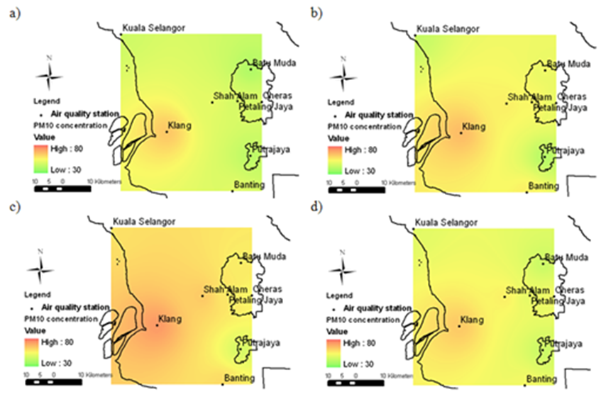
[14]  Shaadan, N., Deni, S. M., & Jemain, A. A., 2012, Comparing the severity of PM10 using functional descriptive statistics: A case study in Klang Valley,Journal of Statistical Model Analysis, 3, 1-10.
[15]  MdYusof, N. F., Ramli, N. A., Yahaya, A. S., Sansuddin, N., Ghazali, N. A., & al Madhoun, W., 2009, Monsoonal differences and probability distribution of PM10 concentration. Environmental Monitoring Assessment, 163, 655-667.
[16]  Ishii, S., Bell, J. N. B., & Marshall, F. M., 2007, Phytotoxic risk assessment of ambient airpollution on agricultural crops in Selangor State, Malaysia. Environmental Pollution, 150, 267-279.
[17]  Dominick, D., Juahir, H., Latif, M. T. C., Zain, S. M., &Aris, A. Z., 2012, Spatial assessment of air quality patterns in Malaysia using multivariate analysis, Atmospheric Environment, 60.
[18]  Jamal, H. H., Pillay, M. S., Zailina, H., Shamsul, B. S., Sinha, K., Zaman Huri, Z., Khew, S.L., Mazrura, S., Ambu, S., Rahimah, A., & Ruzita, M.S., 2004, A Study of Health Impact & Risk Assessment of Urban Air Pollution in Klang Valley, UKM Pakarunding Sdn Bhd, Malaysia, Kuala Lumpur.
[19]  Ding, Y., & J. Chan., 2005, The East Asian summer monsoon: An overview. Meteorology and Atmospheric Physics, 89, 117–142.
[20]  Zhao, C., Wang, Y., Yang, Q., Fu, R., Cunnold, D., & Choi, Y., 2010, Impact of East Asian summer monsoon on the airquality over China: View from space. Journal of Geophysical Research, 115.
[21]  Malaysian Meteorological Department(MMD), 2013, Monsoon, Retrieved 31 August, 2013, from Official Portal Malaysian Meteorological Department:http://www.met.gov.my/index.php?option=com_content&task=view&id=69&Itemid=160
[22]  Syazwani, Z., 2010, Application of GIS in Air Quality Monitoring of a Road Construction Project. Malaysia: Universiti Teknologi Malaysia.
[23]  Barmpadimos, I., Hueglin, C., Keller, J., Henne, S., & Prevot, A. S., 2011, Influence of meteorology on PM10 trends and variability in Switzerland from 1991 to 2008, Atmospheric Chemistry and Physic, 11, 1813-1835
[24]  Rostam, K., 2006, Migration to Klang Valley Metropolitan Peripheral Areas. Akademika, 68, 3-27.
[25]  Department of Statistics Malaysia, 2009. Basic Population Characteristics by Administrative Districts 2009 Report.
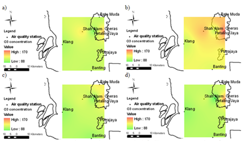
[26]  Ahamad, F., Latif M. T., Dominick, D., & Tang, R., 2012, Daily Maximum Ozone Variability at Selected Urban and Semi-Urban Areas in Peninsular Malaysia. UMT 11th International Annual Symposium on Sustainability Science and Management. Terengganu, Malaysia.
[27]  Department of Environment (DOE)., 2011, Malaysia Environmental Quality Report 2011. Malaysia: Department of Environment.
[28]  Department of Environment Malaysia (DOE), 1997. A Guide to Air Pollutant in Malaysia, (API). Ministry of Science, Technology and Environment, Kuala Lumpur.
[29]  Department of Environment Malaysia, 2013. Malaysia Environmental Quality Report, 2012. Ministry of Science, Technology and Environment, Kuala Lumpur.
[30]  Guilford, J.P., Fruchter, B., 1973. Fundamental statistics in psychology and education. Tokyo: McGraw-Hill Kogakusha, LTD.
[31]  Jolliffe, I.T., 2005, Principal Component Analysis in Encyclopedia statistics in behavioural science. John Wiley & Sons, Ltd. DOI: 10.1002/0470013192.bsa501.
[32]  Jolliffe, I.T., 2002, Principal Component Analysis, second ed. Springer-Verlag, New York.
[33]  Beaumont, R., 2012, An introduction to Principal Component Analysis & Factor Analysis Using SPSS 19 and R (psych package).
[34]  Jolliffe, I.T., 1986, Principal Component Analysis. Springer, New York
[35]  Liu, C.W., Lin, K.H., Kuo, Y.M., 2003. Application of factor analysis in the assessment of groundwater quality in a Blackfoot disease area in Taiwan. Science of the Total Environment 313, 77e89.
[36]  Lu, G. Y. and Wong, D. W., 2008. An adaptive inverse-distance weighting spatial interpolation technique. Computers & Geosciences34: 1044-1055.
[37]  Shah, R. N., Abdullah, J., & Ahmad, Z., 2010, The Physical Development of Port City, Malaysian Universities Transportation Research Forum and Conference 2010 (pp. 269-278), Putrajaya: Universiti Tenaga Nasional.
[38]  Department of Environment (DOE), 2010, Malaysia Environmental Quality Report 2010, Malaysia: Department of Environment.
[39]  Department of Statistic Malaysia, 2010,Population Distribution and Basic Demographic Characteristics 2010. Malaysia: Department of Statistics
[40]  United States Environmental Protection Agency, 2010. Methane and Nitrous Oxide Emissions from Natural Sources. U.S. Environmental Protection Agency, Washington, DC,USA.http://webcache.googleusercontent.com/search?q=cache:FNds6m5eAIwJ:epa.gov/climatechange/ghgemissions/gases/n2o.html+&cd=1&hl=en&ct=clnk.
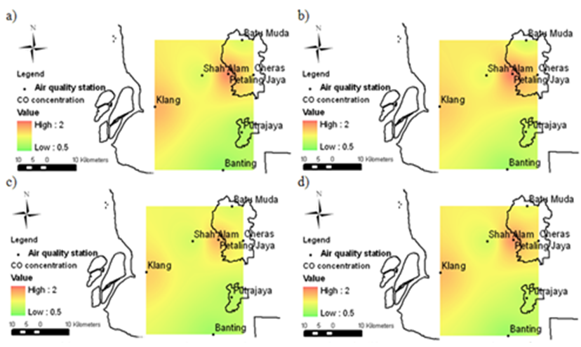
[41]  Rajab, J. M., Tan, K. C., & Jafri, M. Z., 2011, Investigation on the Carbon Monoxide Pollution over Peninsular Malaysia Caused by Indonesia Forest Fires from AIRS Daily Measurement, In F. Nejadkoorki, Advanced Air Pollution (pp. 115-136). InTech.
[42]  Mahmud, M., 2005, Active Fire and Hotspot Emissions in Peninsular Malaysia during 2002 Burning Season, Malaysian Journal of Society and Space, 1, 32-45.
[43]  Chelani, A. B., 2013, Study of Extreme CO, NO2 and O3 Concentrations at a Traffic Site in Delhi: Statistical Persistence Analysis and Source Identification, Aerosol Air Quality Research, 13, 377-384.
[44]  Tey, N. P., 2012, Internal Migration in the Klang Valley of Malaysia: Issues and Implications,Malaysian Journal of China Studies, 1, 40-59.
[45]  Department of Environment (DOE), 2009, Malaysia Environmental Quality Report 2009, Malaysia: Department of Environment.
[46]  Amanollahi, J., Abdullah, A. M., Pirasteh, S., Ramli, & M. F., Rashidi, P., 2011, PM10 monitoring using MODIS AOT and GIS, Kuala Lumpur, Malaysia, Research Journal of Chemistry and Environment, 15, 1-5.
[47]  Chin, M., 2012, Atmospheric science: Dirtier air from a weaker monsoon, Nature Geoscience, 5, 449-450.
[48]  Department of Environment (DOE), 2008, Malaysia Environmental Quality Report 2008, Malaysia: Department of Environment.
[49]  Mansouri, B., Hoshyari, E., & Mansouri, A., 2011, Study on ambient concentrations of air quality parameters (O3, SO2, CO and PM10) in different months in Shiraz city, Iranian International Journal of Environmental Science, 1, 1440-1447.
[50]  Varadarajan, C., 2004. Explore the Link of PM10 with Meteorological Factors and Ambient Air Concentrations of Ozone, CO and NO2 using Time Series for Cleveland, Ohio. Doctoral dissertation, University of Toledo.
[51]  Atkinson, R. W., Yu, D. H., Armstrong, B. G., Pattenden, S., Wilkinson, P., Doherty, R. M., Heal, M. R., & Anderson, H. R., 2012, Concentration–Response Function for Ozone and Daily Mortality: Results from Five Urban and Five Rural U.K. Populations, Environmental Health Perspective, 120, 1411-1417.
[52]  Zhang, L. E., 2006, Ozone-CO correlations determined by the TES satellite instrument in continental outflow regions. Geophysical Research Letters, 33.
[53]  Han, S., Bian, H., Feng, Y., Liu, A., Li, X., Zeng, F., & Zhang, X., 2011, Analysis of the Relationship between O3, NO and NO2 in Tianjin, China, Aerosol Air Quality Research, 11, 128-139.
[54]  Saini, R., Satsangi, G. S., & Taneja, A., 2008, Concentrations of Surface O3, NO2, NO during winter seasons at a semi-arid region - Agra, India, Indian Journal of Radio and Space Physics, 121-130.
[55]  Mao, H., & Talbot, R., 2004, O3 and CO in New England: Temporal variations and relationships,Journal of Geophysical Research, 109, 21304.
[56]  Real, E. E., 2008, Lagrangian analysis of low altitude anthropogenic plume processing across the Nort Athlantic. Atmospheric Chemistry and Physics, 8, 7737-7754.
[57]  Ayres, R. U., & Ayres, E. H., 2009, Crossing the Energy Divide: Moving from Fossil Fuel Dependence to a Clear-Energy Future, Wharton School Publishing.
[58]  Hare, S., Cresswell, L., Twigg, R., & Buchdal, J., 2002, Air Pollution. 2002: Atmosphere, Climate and Environment Information Programme.
[59]  Verma, S. S, & Desa, B., 2008, Effect of Meteorological Conditions on Air Pollutions of Surat City,Journal of International Environmental Application Science, 3, 358-367.
[60]  Schlenker, W., & Walker, W. R., 2012, Airports, Air Pollution, and Contemporaneus Health. Robert Wood Johnsoon Foundation.